Items Similar to Map of Avenches Region Switzerland by Mercator, Original 1585 Engraving


Want more images or videos?
Request additional images or videos from the seller
1 of 10
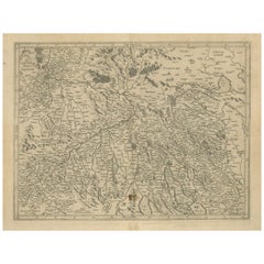
Map of Avenches Region Switzerland by Mercator, Original 1585 Engraving
$646.78
£479.30
€540
CA$882.98
A$982.28
CHF 514.92
MX$12,003.17
NOK 6,556.88
SEK 6,172.39
DKK 4,111.51
Shipping
Retrieving quote...The 1stDibs Promise:
Authenticity Guarantee,
Money-Back Guarantee,
24-Hour Cancellation
About the Item
Map of Wiflispurgergov by Gerardus Mercator, Avenches Region, 1585
This rare and finely engraved map, titled *Das Wiflispurgergov*, was produced by Gerardus Mercator and published in Duisburg in 1585. It offers a detailed representation of the historical Wiflispurger region, located around Avenches in western Switzerland, bordering Lake Geneva. The map is engraved in Mercator’s meticulous style and features rich topographical detail, including mountains, rivers, cities, and towns, all labeled in early modern Latin or German script.
The map reflects the region as it was known in the late 16th century, with particular focus on political and ecclesiastical territories. Mountain ranges are represented pictorially with stylized hachures, and water bodies such as the Lacus Lemanus (Lake Geneva) are beautifully shaded and populated with sailing ships, including a galleon depicted just offshore.
The title cartouche in the upper left is presented in elaborate strapwork, typical of the period, reading *Das Wiflispurgergov per Gerardum Mercatore. Cum Privilegio*. The “privilege” refers to the publishing rights granted to Mercator, indicating this was part of his authorized atlas production. This map originally appeared in Mercator’s Atlas, the first work to bear the title “atlas” and a milestone in European cartographic history.
Mercator (1512–1594) was a Flemish geographer and cartographer, best known for the Mercator projection, a method of mapmaking that became foundational for nautical navigation. His 1585 map series of various European regions, including parts of Switzerland, was an early step toward the complete publication of his world atlas, later expanded by his son Rumold and reissued by Jodocus Hondius after Mercator’s death.
This particular map is a wonderful example of early modern cartographic precision, reflecting both Mercator’s scholarly training and his artistic sensibility. The rendering of place names and geographical forms captures a uniquely Renaissance view of the Swiss landscape and its administrative divisions.
Condition Report:
Uncolored copperplate engraving on laid paper. Light toning and several small marginal stains. Centerfold as issued. No tears or restoration. A strong impression with sharp linework throughout.
Tips for Framing:
Frame with walnut or ebony molding and a light cream or parchment-tone mat to complement the antique paper. Consider a wide mat border and UV-protective glass to enhance visual presence and long-term preservation.
- Dimensions:Height: 17.52 in (44.5 cm)Width: 21.66 in (55 cm)Depth: 0.01 in (0.2 mm)
- Materials and Techniques:Paper,Engraved
- Place of Origin:
- Period:
- Date of Manufacture:1585
- Condition:Uncolored copperplate engraving on laid paper. Light toning and several small marginal stains. Centerfold as issued. No tears or restoration. A strong impression with sharp linework throughout.
- Seller Location:Langweer, NL
- Reference Number:Seller: BG-13667-31stDibs: LU3054345324112
About the Seller
5.0
Recognized Seller
These prestigious sellers are industry leaders and represent the highest echelon for item quality and design.
Platinum Seller
Premium sellers with a 4.7+ rating and 24-hour response times
Established in 2009
1stDibs seller since 2017
2,494 sales on 1stDibs
Typical response time: 1 hour
- ShippingRetrieving quote...Shipping from: Langweer, Netherlands
- Return Policy
Authenticity Guarantee
In the unlikely event there’s an issue with an item’s authenticity, contact us within 1 year for a full refund. DetailsMoney-Back Guarantee
If your item is not as described, is damaged in transit, or does not arrive, contact us within 7 days for a full refund. Details24-Hour Cancellation
You have a 24-hour grace period in which to reconsider your purchase, with no questions asked.Vetted Professional Sellers
Our world-class sellers must adhere to strict standards for service and quality, maintaining the integrity of our listings.Price-Match Guarantee
If you find that a seller listed the same item for a lower price elsewhere, we’ll match it.Trusted Global Delivery
Our best-in-class carrier network provides specialized shipping options worldwide, including custom delivery.More From This Seller
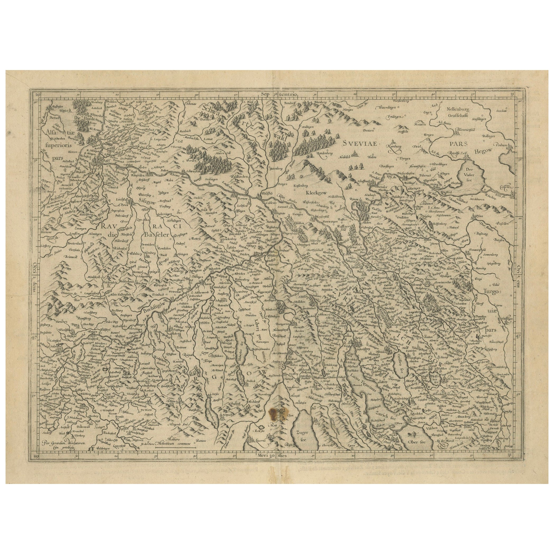
View AllMap of Zurich and Basel Region by Mercator, Uncolored Engraving c.1600
Located in Langweer, NL
Map of Zurich and Basel Region by Mercator, Uncolored Engraving c.1600
This original uncolored copperplate engraving, titled *Zurichgow et Basiliensis Provincia*, was created by the...
Category
Antique Early 17th Century Maps
Materials
Paper
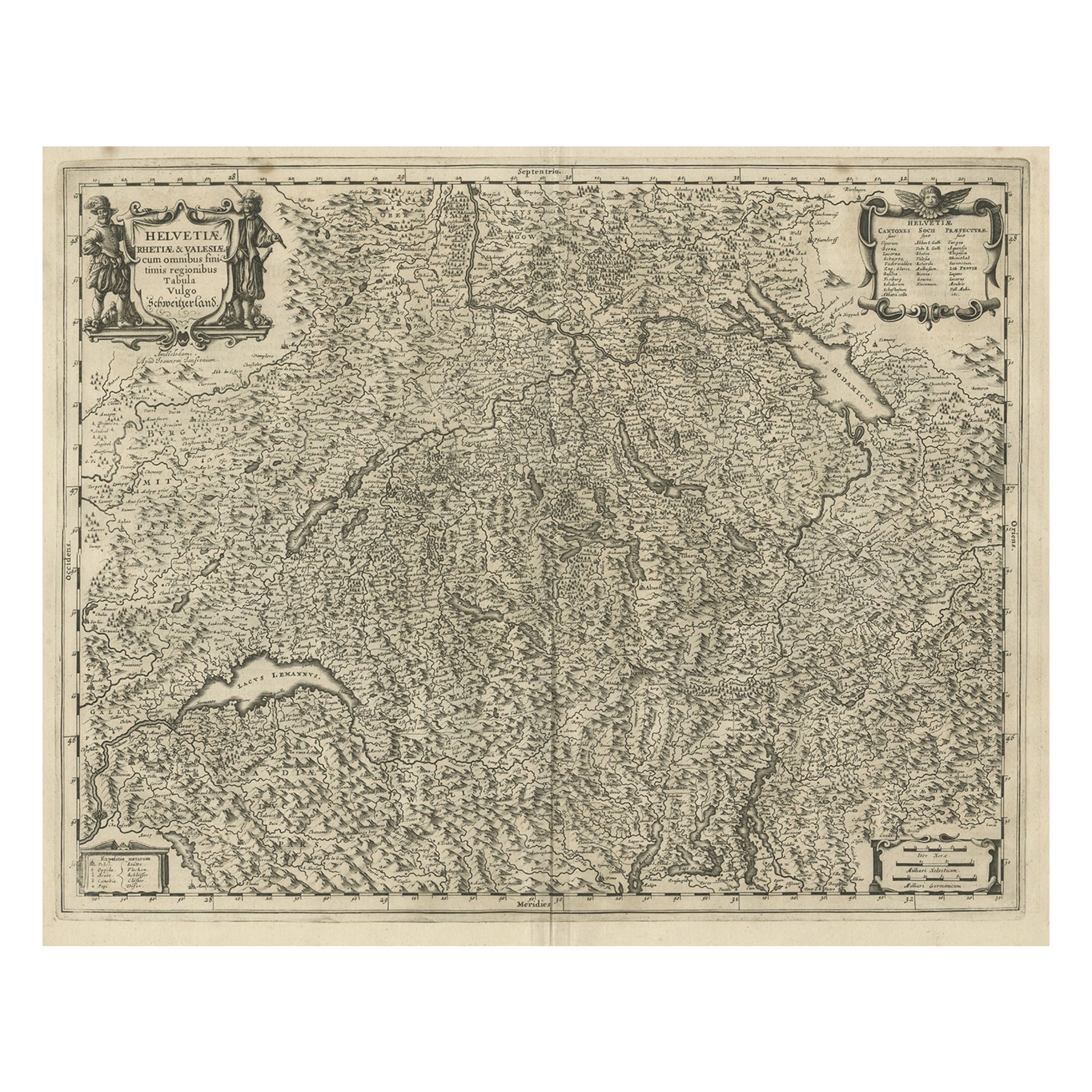
Decorative and Detailed Original Antique Map of Switzerland, 1657
Located in Langweer, NL
Antique map of Switzerland titled 'Helvetiae Rhetiae & Valesiae'.
Decorative and detailed map of Switzerland. This map originates from 'Atlas Novus, Sive Theatrum Orbis Orbis Ter...
Category
Antique 1650s Maps
Materials
Paper
$824 Sale Price
20% Off
Antique Map of Switzerland by Janssonius, 1657
Located in Langweer, NL
Antique map of Switzerland titled 'Helvetiae Rhetiae & Valesiae'. Decorative and detailed map of Switzerland. This map originates from 'Atla...
Category
Antique 17th Century Maps
Materials
Paper

$502 Sale Price
20% Off
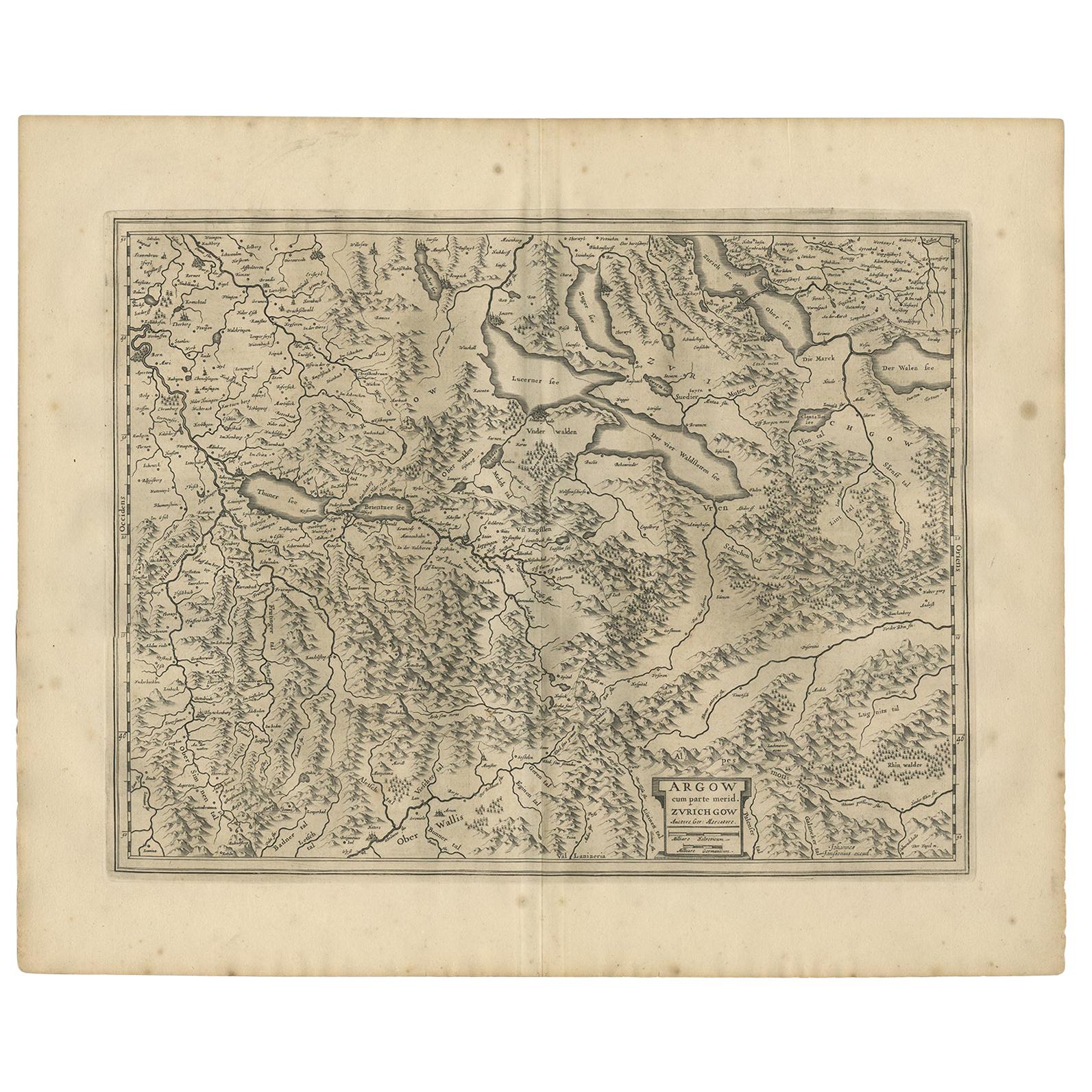
Antique Map of the Region of Aargau by Janssonius, '1657'
By Johannes Janssonius
Located in Langweer, NL
Antique map 'Argow cum parte merid. Zurichgow'. Detailed map of Switzerland showing Aargau with the southern part of Zürich. This map originates from 'Atlas Novus, Sive Theatrum Orbi...
Category
Antique Mid-17th Century Maps
Materials
Paper
$574 Sale Price
20% Off
Antique Map of Northern Switzerland by Janssonius '1657'
By Johannes Janssonius
Located in Langweer, NL
Antique map 'Zurichgow et Basiliensis provincia'. Detailed map of northern Switzerland, including Zurich and Basel. This map originates from 'Atlas Novus, Sive Theatrum Orbis Orbis T...
Category
Antique Mid-17th Century Maps
Materials
Paper

$527 Sale Price
20% Off
Antique Map of Bavaria ‘Bayern, Germany’ by N. Visscher, circa 1700
Located in Langweer, NL
Antique map titled 'Bavariae pars inferior cum insertis et adjacentibus regionibus (..)'. Published circa 1700 in N. Visscher's World Atlas.
The map "Bavariae pars inferior cum inse...
Category
Antique Early 18th Century Dutch Maps
Materials
Paper
$584 Sale Price
20% Off
You May Also Like
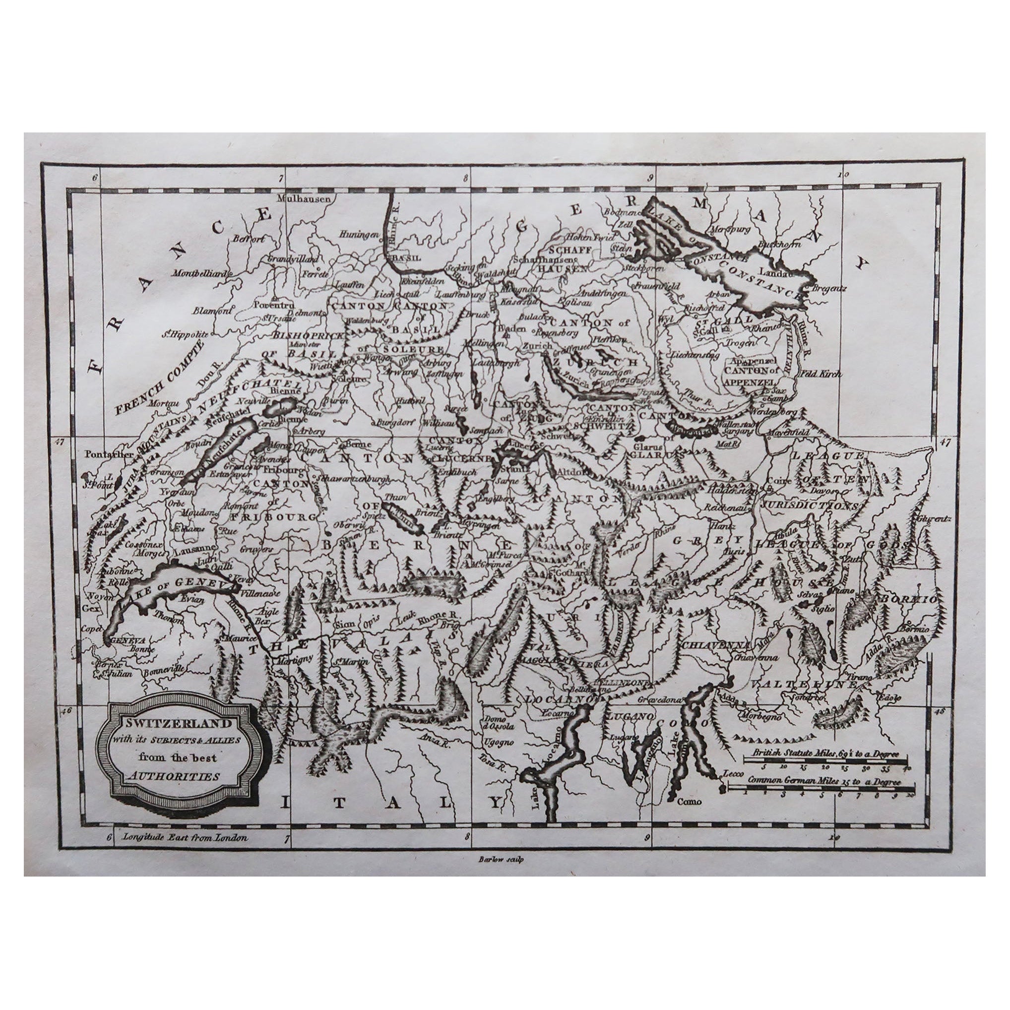
Original Antique Map of Switzerland, Engraved By Barlow, Dated 1807
Located in St Annes, Lancashire
Great map of Switzerland
Copper-plate engraving by Barlow
Published by Brightly & Kinnersly, Bungay, Suffolk.
Dated 1807
Unframed.
Category
Antique Early 1800s English Maps
Materials
Paper

1657 Janssonius Map of Vermandois and Cappelle, Ric. A-004
Located in Norton, MA
1657 Janssonius map of
Vermandois and Cappelle
Ric.a004
Description: Antique map of France titled 'Descriptio Veromanduorum - Gouvernement de la Cappelle'. Two detailed maps o...
Category
Antique 17th Century Unknown Maps
Materials
Paper

Engraving Depicting 16th Century Map of Terra Sancta
Located in Buchanan, MI
Abraham Ortelius (Flemish, 1527-1598) Terra Sancta.
Engraving depicting 16th century map of Terra Sancta. Site 15" x 19.5.
Category
Antique 18th Century and Earlier Maps
Materials
Paper

1640 Joan Bleau Map Entitled"Diocecese de rheims et le pais de rethel, " Eic.a011
Located in Norton, MA
1640 Joan Bleau map entitled
"Diocecese de rheims et le pais de rethel,"
Ric.a011
OAN BLAEU
Diocecese de Rheims, et le pais de Rethel.
Handcolored engraving, c.1640.
...
Category
Antique 17th Century Dutch Maps
Materials
Paper

1656 Jansson Map Metz Region of France Entitled "Territorium Metense" Ric0014
Located in Norton, MA
1656 Jansson map Metz Region of France entitled "Territorium Metense."
Ric0014
" Authentic" - Map of the historical region surrounding Metz, in Lorraine, France.
Oriented with ...
Category
Antique 17th Century Dutch Maps
Materials
Paper

1592 Abraham Ortelius Map "Lorraine: Lotharingiae Nova Descripti, Ric.A005
Located in Norton, MA
1592 Abraham Ortelius map entitled
"Lorraine: Lotharingiae Nova Descripti
Ric.a005
Description: Ortelius is best known for producing the atlas from which this map comes from, "...
Category
Antique 16th Century Dutch Maps
Materials
Paper

More Ways To Browse
Antique Script
Swiss Mountain Furniture
6x10 Rug
Styles Of Antique Desks
Black And White Coffee Table
Metal Relief
Curved Velvet Couch
Velvet Curved Sofa
Wood Round Coffee Tables
Antique Paper Flowers
Oak Brutalist
Used College Furniture
Wood Minimalist Chair
2002 Lamp
Antique Imperial Furniture
Gold Modern Coffee Table
Large Side Tables
18th Century Gilded Furniture