Items Similar to 1640 Joan Bleau Map Entitled"Diocecese de rheims et le pais de rethel, " Eic.a011

Want more images or videos?
Request additional images or videos from the seller
1 of 5
1640 Joan Bleau Map Entitled"Diocecese de rheims et le pais de rethel, " Eic.a011
About the Item
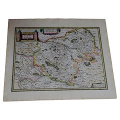
1640 Joan Bleau map entitled
"Diocecese de rheims et le pais de rethel,"
Ric.a011
OAN BLAEU
Diocecese de Rheims, et le pais de Rethel.
Handcolored engraving, c.1640.
A fine map of the Reims and Rethel region of France from a Latin text edition of Blaeu's Atlas Novus. A nicely colored impression.
Dimension: Paper Size: 23 5/8" W x 19 1/4" H (60 cm W x 49 cm H)
Date: 17th century
Condition: Good Condition with age, please see photos.
; Image Size: 20 3/4" W x 16 1/8" H (52.7 cm W x 41 cm H).
- Dimensions:Height: 19.3 in (49 cm)Width: 23.63 in (60 cm)Depth: 0.4 in (1 cm)
- Materials and Techniques:
- Place of Origin:
- Period:
- Date of Manufacture:1640
- Condition:
- Seller Location:Norton, MA
- Reference Number:1stDibs: LU5848230191052
About the Seller
5.0
Platinum Seller
These expertly vetted sellers are 1stDibs' most experienced sellers and are rated highest by our customers.
Established in 2000
1stDibs seller since 2021
85 sales on 1stDibs
Typical response time: <1 hour
- ShippingRetrieving quote...Ships From: Norton, MA
- Return PolicyA return for this item may be initiated within 3 days of delivery.
More From This SellerView All
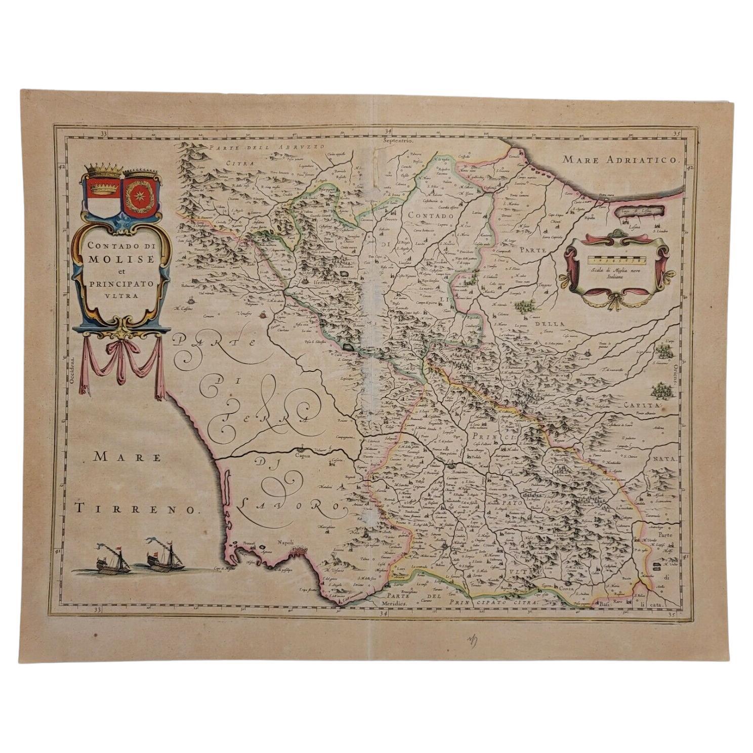
- 1640 Willem Blaeu Map Entitled "Contado di molise et principato vltra, " Ric.a003By Willem BlaeuLocated in Norton, MA1640 Willem Blaeu map entitled "Contado di molise et principato vltra," Colored Ric. a003 Measures: 38 x 49.6 cm and wide margins DBLAEU. Cou...Category
Antique 17th Century Dutch Maps
MaterialsPaper
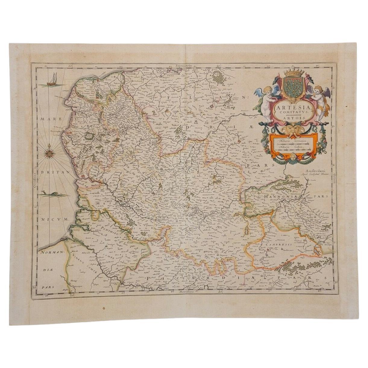
- 1620 Map of Artois Entitled "Artesia Comitatvs Artois, " by Bleau, Ric.a012Located in Norton, MA1640 map of Artois entitled "Artesia Comitatvs Artois," by Bleau Colored A-012. Detailed map of the northern province of Artois, France on the border with Belgium. Feature...Category
Antique 17th Century Dutch Maps
MaterialsPaper
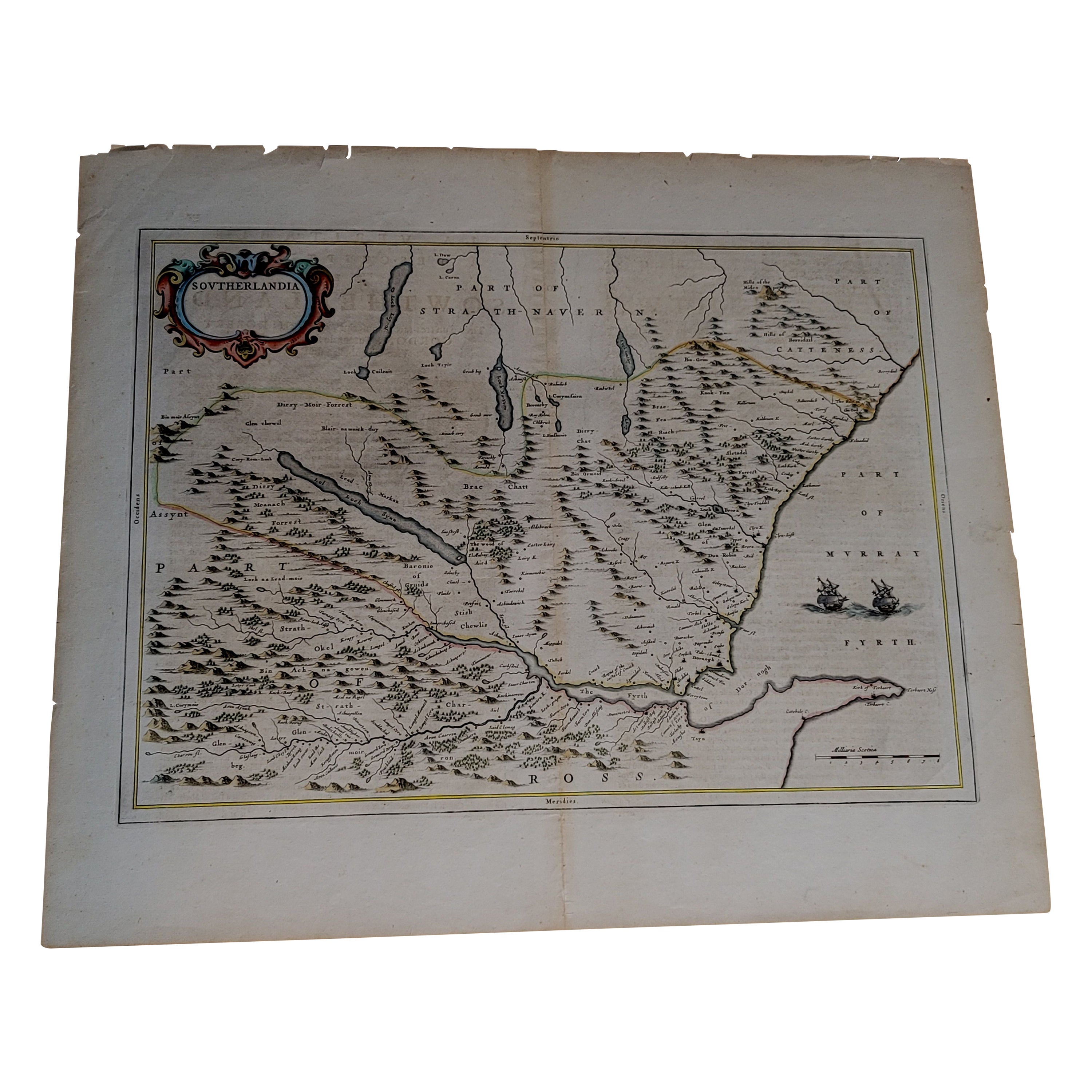
- 1654 Joan Blaeu Map the Sutherland, Scotland, Entitled "Southerlandia, "Ric0007Located in Norton, MA1654 Joan Blaeu map of the Sutherland, Scotland, entitled "Southerlandia," Hand Colored Ric0007 Description: Lovely map centered on Sedan and D...Category
Antique 17th Century Dutch Maps
MaterialsPaper
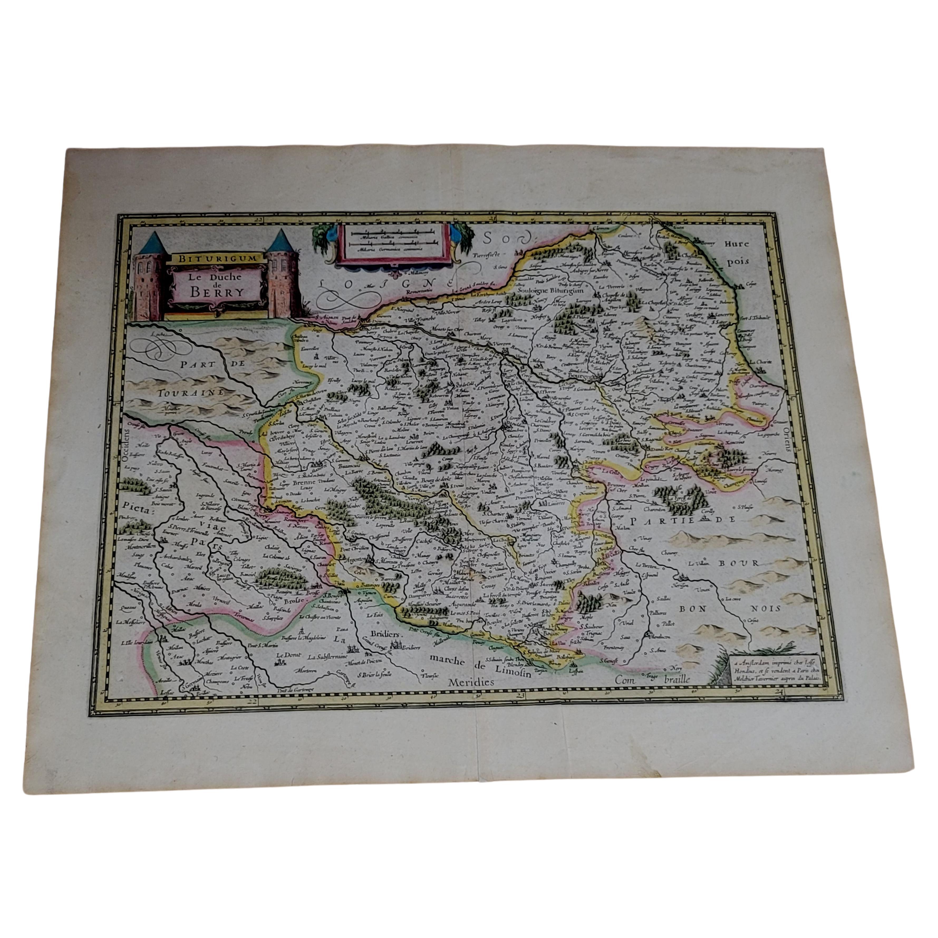
- 1633 Map, Entitled "La Douche De Berry, " Ric.0005Located in Norton, MA1633 map, entitled "La douche de Berry," Hand Colored Ric.0005 Description: 1633 map, entitled "La douche de Berry," Dimension: Paper: 23.3" W x 20.3" H (59 cm W x 51.7 c...Category
Antique 17th Century Unknown Maps
MaterialsPaper
- 1633 Map "La Souverainete De Sedan Et De Raucourt, Et La Prevoste Ric0011Located in Norton, MA1653 map entitled "La Souverainete de Sedan et de Raucourt, et la Prevoste de Doncheri," Ric0011 Description: Lovely map centered on Sedan and Doncheri and the Meuze River fr...Category
Antique 17th Century Dutch Maps
MaterialsPaper
- 1633 map, entitled "La douche de Berry, " Original Hand Colored Ric.0005Located in Norton, MA1633 map, entitled "La douche de Berry," Hand Colored Ric.0005 Description: 1633 map, entitled "La douche de Berry," Dimension: Paper: 23.3" W x 20.3" H (59 cm W x 51.7 cm H) ; ...Category
Antique 17th Century Dutch Maps
MaterialsPaper


You May Also Like
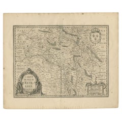
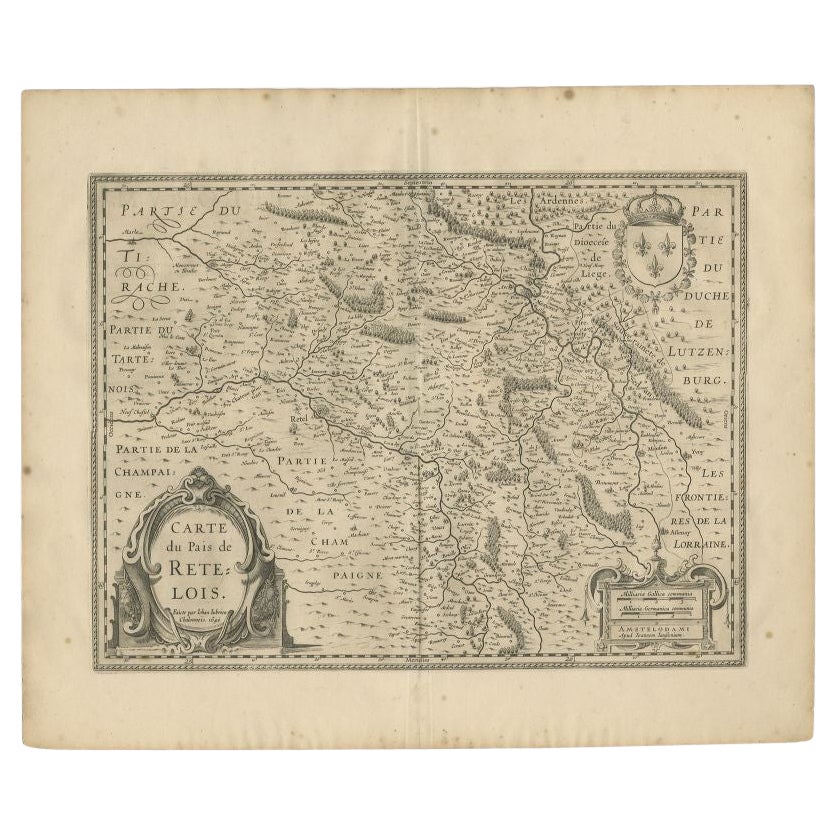
- Antique Map of the Region of Rethel by Janssonius, 1657By Johannes JanssoniusLocated in Langweer, NLAntique map of France titled 'Carte du Pais de Retelois'. Detailed map of the region of Rethel in the north east of France. Showing the city of Rethel, Moncornet en Tirache, Beaumont...Category
Antique 17th Century Maps
MaterialsPaper
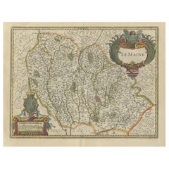
- Antique Map of the Region of Le Mans 'France' by Blaeu, circa 1640By Willem BlaeuLocated in Langweer, NLAntique map titled 'Cenomanorum Galliae regionis typus vulgo le Mans'. This lovely map of the historical province of Maine is centered on the famous city of Le Mans. This region witn...Category
Antique Mid-17th Century Maps
MaterialsPaper
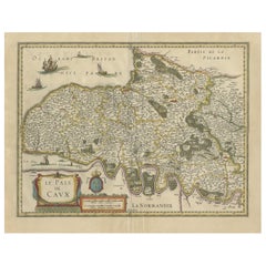
- Old Handcolored Antique Map of Pays De Caux in Normandy, France, ca.1640Located in Langweer, NLAntique map titled 'Le Pais de Caux'. Old map of Pays de Caux, France. Pays de Caux is an area in Normandy occupying the greater part of the French département of Seine Maritime ...Category
Antique 1640s Maps
MaterialsPaper
- Antique Map of the French Province Maine, Showing Le Mans, Alencon Etc., Ca1640Located in Langweer, NLAntique map titled 'Le Maine'. Old map of the province of Maine, France. It shows the cities of Le Mans, Alencon and others. This map originates from a composite atlas. Artis...Category
Antique 1640s Maps
MaterialsPaper
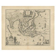
- Antique Map of Southeast Asia by Blaeu, c.1640Located in Langweer, NL"Antique map titled 'India quae Orientalis dicitur et Insulae adiacentes'. Map of Southeast Asia, extending from India to Tibet to Japan to New Guinea. This map is one of the first t...Category
Antique 17th Century Maps
MaterialsPaper
- Antique Map of the Maluku Islands by Blaeu, c.1640Located in Langweer, NLAntique map titled 'Moluccae Insulae Celeberrimae'. Decorative map of the Maluku Islands, also known as the Moluccas or the Spice Islands. Inset of the island of Bachian (Batjan) in ...Category
Antique 17th Century Maps
MaterialsPaper