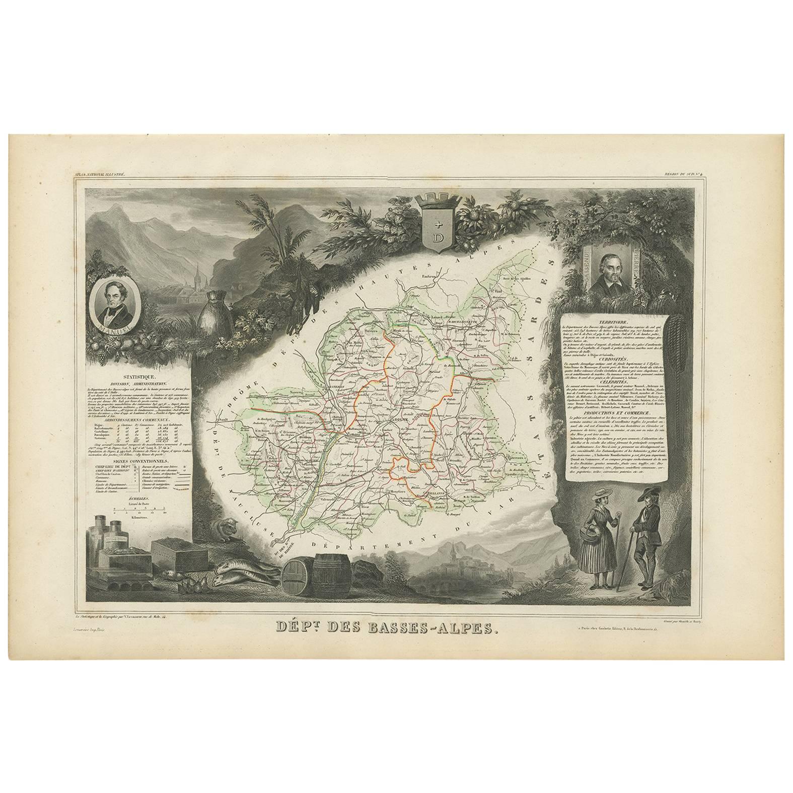
Items Similar to Map of Basses-Alpes France with Digne and Lavender Region by Vuillemin, c.1850


Want more images or videos?
Request additional images or videos from the seller
1 of 10
Map of Basses-Alpes France with Digne and Lavender Region by Vuillemin, c.1850
$143.90
£107.05
€120
CA$197.05
A$219.09
CHF 114.40
MX$2,666.90
NOK 1,459.67
SEK 1,367.64
DKK 913.49
Shipping
Retrieving quote...The 1stDibs Promise:
Authenticity Guarantee,
Money-Back Guarantee,
24-Hour Cancellation
About the Item
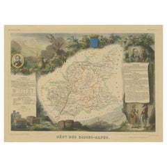
Map of Basses-Alpes France with Digne and Lavender Region by Vuillemin, 19th c
This finely engraved 19th-century map of the Basses-Alpes department of France (known today as Alpes-de-Haute-Provence) is from the renowned Nouvel Atlas Illustré by Alexandre Vuillemin, published by Migeon in Paris. It features delicate hand coloring, regional detail, and elegant vignettes that highlight the cultural and natural identity of the area.
The map outlines the department of Basses-Alpes with clear detail, showcasing towns, rivers, and roads, bordered in soft pastel colors. The mountains, passes, and valleys are rendered with precision, reflecting the department's alpine geography. In the upper left corner, a vignette depicts the town of Digne (now Digne-les-Bains), the administrative center of the department, with the Alps rising in the distance. The bottom left corner features a mountain goat resting on the rocks—an allusion to the region’s wildlife and rugged landscape. To the right, a portrait of Jean-Baptiste Gassendi, philosopher, astronomer, and native of the region, brings historical depth to the composition. Birds flying along the right edge further emphasize the natural richness of the region.
Basses-Alpes is particularly renowned for its stunning lavender fields, which blanket the landscape in purple during summer months. This region, especially the areas around Digne, Forcalquier, and Valensole, is one of the key sources of French lavender, used in perfumes, soaps, and essential oils. In addition to lavender, the region also produces honey, olives, and wines from the Vin de Pays des Alpes-de-Haute-Provence designation.
Alexandre Vuillemin, the cartographer, was a noted 19th-century French mapmaker whose decorative atlases combined geography with culture and art. His publisher, Migeon, specialized in beautifully illustrated educational works. Together, they produced maps that were both informative and visually compelling, popular among scholars and collectors alike.
Condition summary:
Very good condition with slight toning to the margins and a few faint foxing spots, mostly in outer areas. The engraved details are sharp and the original hand-coloring remains clean and attractive.
Framing tips:
This map pairs beautifully with a medium or dark wood frame, or an antique gold moulding to highlight the historic charm. A soft cream or light lavender-toned mat can complement the regional theme. UV-protective glass is recommended to ensure long-term preservation.
- Dimensions:Height: 10.28 in (26.1 cm)Width: 12.8 in (32.5 cm)Depth: 0.01 in (0.2 mm)
- Materials and Techniques:Paper,Engraved
- Place of Origin:
- Period:
- Date of Manufacture:circa 1850
- Condition:Very good condition with slight toning to the margins and a few faint foxing spots, mostly in outer areas. The engraved details are sharp and the original hand-coloring remains clean and attractive.
- Seller Location:Langweer, NL
- Reference Number:Seller: BG-13331-41stDibs: LU3054345359142
About the Seller
5.0
Recognized Seller
These prestigious sellers are industry leaders and represent the highest echelon for item quality and design.
Platinum Seller
Premium sellers with a 4.7+ rating and 24-hour response times
Established in 2009
1stDibs seller since 2017
2,511 sales on 1stDibs
Typical response time: <1 hour
- ShippingRetrieving quote...Shipping from: Langweer, Netherlands
- Return Policy
Authenticity Guarantee
In the unlikely event there’s an issue with an item’s authenticity, contact us within 1 year for a full refund. DetailsMoney-Back Guarantee
If your item is not as described, is damaged in transit, or does not arrive, contact us within 7 days for a full refund. Details24-Hour Cancellation
You have a 24-hour grace period in which to reconsider your purchase, with no questions asked.Vetted Professional Sellers
Our world-class sellers must adhere to strict standards for service and quality, maintaining the integrity of our listings.Price-Match Guarantee
If you find that a seller listed the same item for a lower price elsewhere, we’ll match it.Trusted Global Delivery
Our best-in-class carrier network provides specialized shipping options worldwide, including custom delivery.More From This Seller
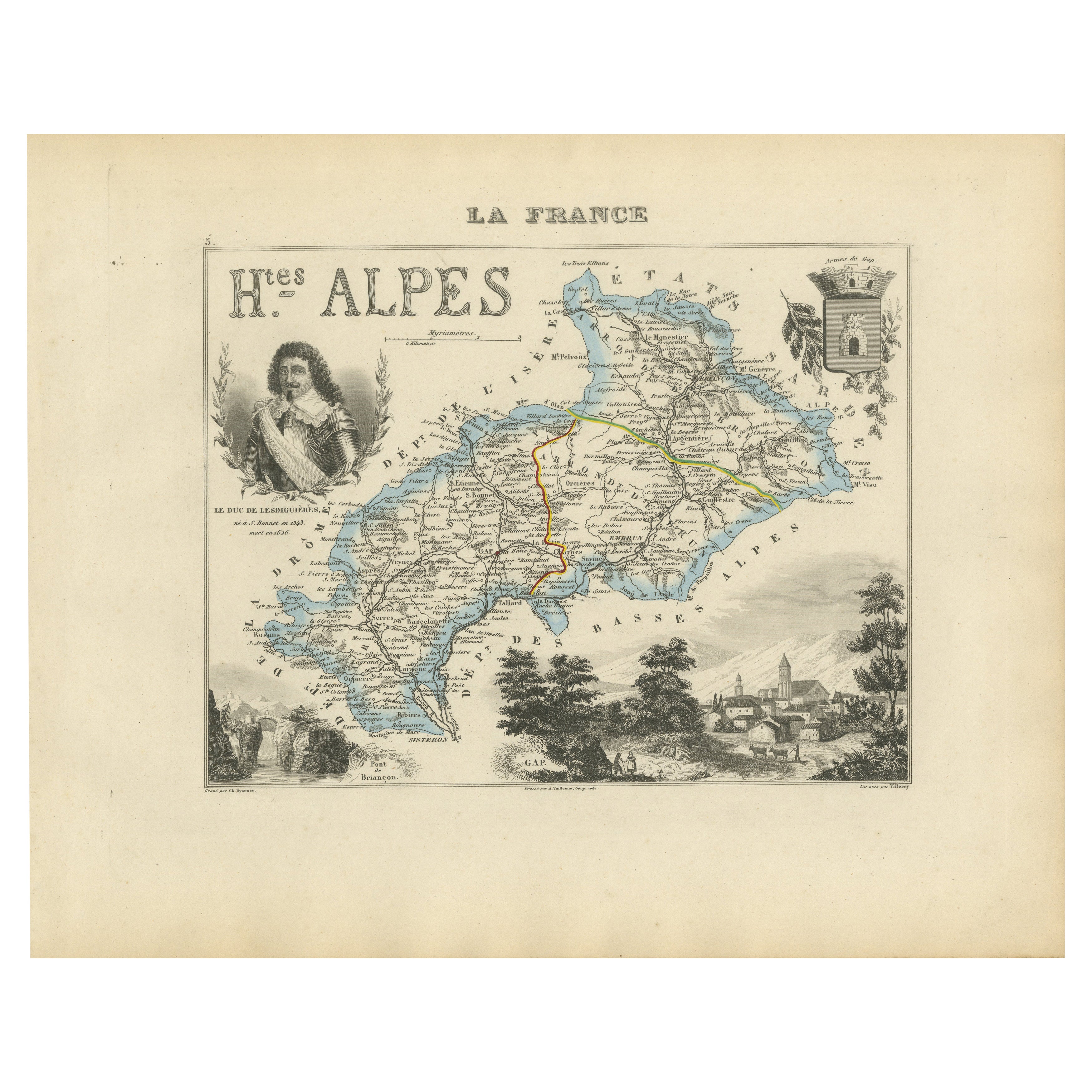
View AllMap of Hautes-Alpes France with Gap and Alpine Scenery by Vuillemin, c.1850
Located in Langweer, NL
Map of Hautes-Alpes France with Gap and Alpine Scenery by Vuillemin
Description:
This elegant 19th-century map of the Hautes-Alpes department in southeastern France was created by A...
Category
Antique Mid-19th Century French Maps
Materials
Paper

Map of Ain France with Vineyards of Bugey and Notable Portraits, c.1850
Located in Langweer, NL
Map of Ain France with Portraits of Bichat and Joubert by Vuillemin, 19th c
This highly decorative 19th-century map of the French department of Ain is taken from the celebrated Nouv...
Category
Antique Mid-19th Century French Maps
Materials
Paper

Antique Map of Basses-Alpes ‘France’ by V. Levasseur, 1854
By Victor Levasseur
Located in Langweer, NL
Antique map titled 'Dépt. des Basses-Alpes'. Map of the French department of Basses-Alpes, France. The whole is surrounded by elaborate decorative engravings designed to illustrate b...
Category
Antique Mid-19th Century Maps
Materials
Paper
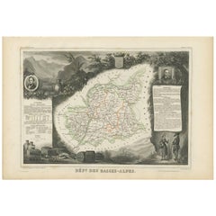
$191 Sale Price
20% Off
Map of Ariège France with Foix and Pyrenees Landscape by Vuillemin, 19th c
Located in Langweer, NL
Map of Ariège France with Foix and Pyrenees Landscape by Vuillemin, 19th c
Description:
This beautifully detailed 19th-century map of the Ariège department in southwestern France wa...
Category
Antique Mid-19th Century French Maps
Materials
Paper

Map of Allier France with Saint-Pourçain Wine Region by Vuillemin, 19th c
Located in Langweer, NL
Map of Allier France with Saint-Pourçain Wine Region by Vuillemin, 19th c
This decorative 19th-century map of Allier, a central department of France, comes from the celebrated Nouve...
Category
Antique Mid-19th Century French Maps
Materials
Paper

Hand Colored Antique Map of the Department of Basses-Alpes, France
By Victor Levasseur
Located in Langweer, NL
Antique map titled 'Dépt. de l'Aube'. Map of the French department of Basses-Alpes, France. The whole is surrounded by elaborate decorative engravings designed to illustrate both the...
Category
Antique Mid-19th Century Maps
Materials
Paper
$326 Sale Price
20% Off
You May Also Like
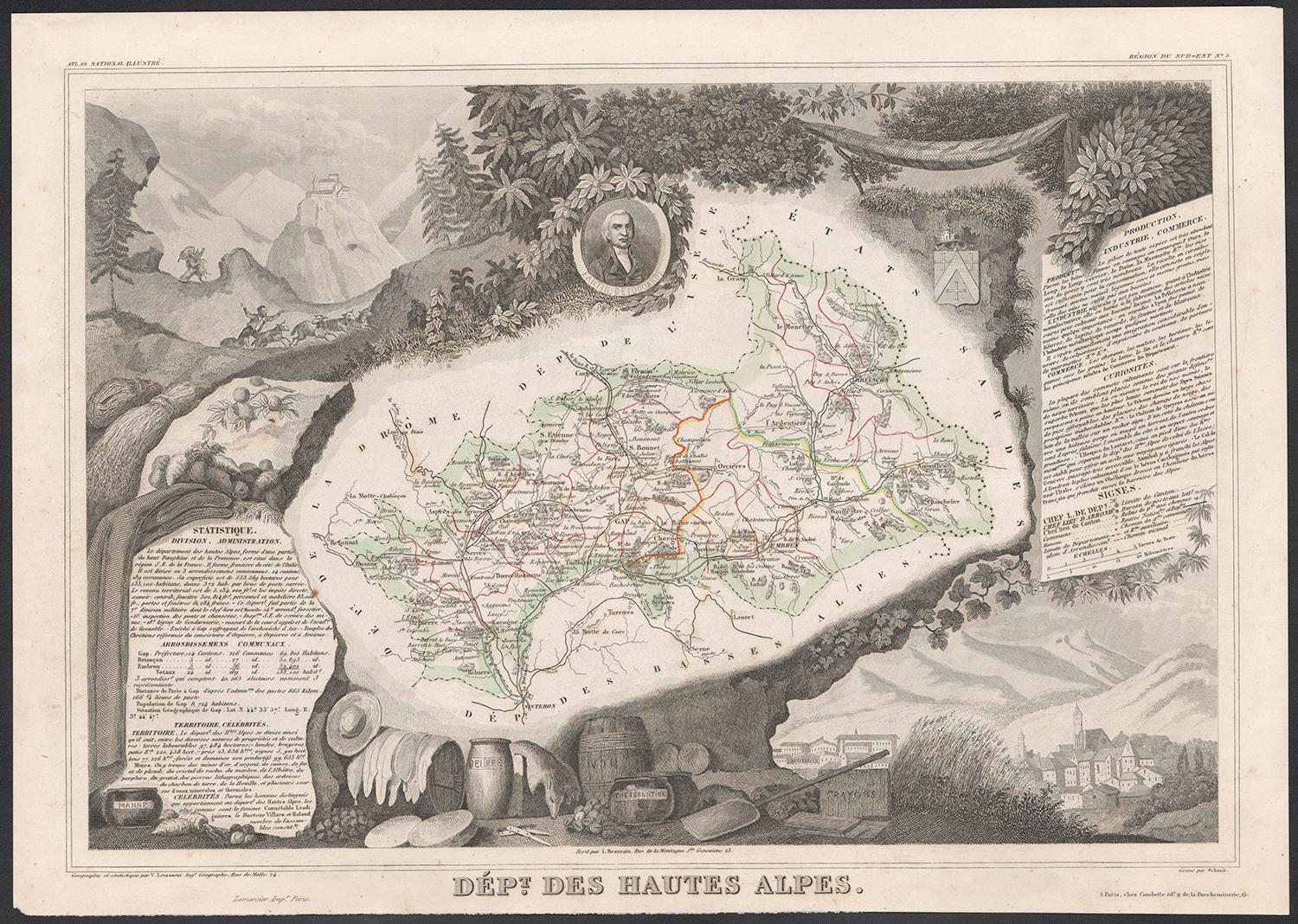
Hautes Alpes, France. Antique map of a French department, 1856
By Victor Levasseur
Located in Melbourne, Victoria
'Dept. des Hautes Alpes', steel engraving with original outline hand-colouring., 1856, from Levasseur's 'Atlas National Illustre'.
This area of France i...
Category
19th Century Naturalistic Landscape Prints
Materials
Engraving

Hautes Pyrenees, France. Antique map of a French department, 1856
By Victor Levasseur
Located in Melbourne, Victoria
'Dept. des Hautes Pyrenees', steel engraving with original outline hand-colouring., 1856, from Levasseur's Atlas National Illustre.
This area is home to the wine producing region, ...
Category
19th Century Naturalistic Landscape Prints
Materials
Engraving
Pyrenees Orientales, France. Antique map of a French department, 1856
By Victor Levasseur
Located in Melbourne, Victoria
'Dept. des Pyrenees Orientales', steel engraving with original outline hand-colouring., 1856, from Levasseur's 'Atlas National Illustre'.
This area is well-known wine producing reg...
Category
19th Century Naturalistic Landscape Prints
Materials
Engraving

Hautes-Pyrénées Map - Original Lithograph - 19th Century
Located in Roma, IT
Hautes-Pyrénées Map is an original lithograph realized by an Anonymous engraver of the 19th Century.
Printed in series of "France Pittoresque" at the top center.
The state of prese...
Category
19th Century Modern Figurative Prints
Materials
Paper, Lithograph

Fine Antique 1856 Hand Watercolour Map of Dept Des Hautes Alpes by Levasseur's
Located in West Sussex, Pulborough
We are delighted to offer for sale this stunning 1856 hand watercolour map of the Austrian Alps titled Dept Des Hautes Alpes taken from the Atlas National...
Category
Antique 1850s French Early Victorian Maps
Materials
Paper

Lozere, France. Antique map of a French department, 1856
By Victor Levasseur
Located in Melbourne, Victoria
'Dept. de La Lozere', steel engraving with original outline hand-colouring., 1856, from Levasseur's 'Atlas National Illustre'.
This remote mountainous part of Languedoc is rural, s...
Category
19th Century Naturalistic Landscape Prints
Materials
Engraving

More Ways To Browse
Lavender Fields
Antique Cream Can
Antique Cream Cans
Perfume Charms
French Wine Map
Alpes Furniture
Purple Wine Glass
Nouvel Glass
Antique Purple Wine Glasses
Fox Blanket
6x10 Rug
Styles Of Antique Desks
Black And White Coffee Table
Metal Relief
Curved Velvet Couch
Velvet Curved Sofa
Wood Round Coffee Tables
Antique Paper Flowers