Items Similar to Map of Côtes-du-Nord France with Saint-Brieuc and Brittany Coastline, c.1850


Want more images or videos?
Request additional images or videos from the seller
1 of 10
Map of Côtes-du-Nord France with Saint-Brieuc and Brittany Coastline, c.1850
$143.90
£107.05
€120
CA$197.05
A$219.09
CHF 114.40
MX$2,666.90
NOK 1,459.67
SEK 1,367.64
DKK 913.49
Shipping
Retrieving quote...The 1stDibs Promise:
Authenticity Guarantee,
Money-Back Guarantee,
24-Hour Cancellation
About the Item
Map of Côtes-du-Nord France with Saint-Brieuc and Brittany Coastline, 19th c
Description:
This elegant 19th-century map of Côtes-du-Nord, the historic name for what is now known as Côtes-d’Armor in Brittany, was created by Alexandre Vuillemin and published by Migeon in Paris for the *Nouvel Atlas Illustré*. Blending precise cartographic detail with finely engraved embellishments, the map presents the coastal and inland features of this northwestern French department.
The map outlines Côtes-du-Nord in soft pink hand-coloring and carefully labels towns, rivers, and roadways. Saint-Brieuc, the prefecture, is centrally located along the northern coast, while other important towns such as Dinan, Lannion, Guingamp, and Loudéac are also marked. The geography reflects the area’s rugged coastlines, with peninsulas, small bays, and offshore islands rendered with care. The northern boundary is bordered by the English Channel, historically vital for trade and maritime activity.
A charming vignette at the top right depicts the Breton countryside with a wayside cross and a rural village in the distance—an homage to the region’s deep Catholic and pastoral traditions. In the lower right corner is a portrait of Jean-Marie de Lamennais, a prominent 19th-century priest and educational reformer from the region. The coat of arms, accompanied by a decorative banner, appears at bottom left, adding a heraldic touch.
Côtes-du-Nord, now Côtes-d’Armor, is part of historic Brittany and known for its strong cultural identity, Celtic heritage, and rich agricultural landscape. While not famous for wine, the region is renowned for apple orchards and traditional Breton cider production. It is also known for dairy, salt production, fishing, and religious architecture, including numerous chapels and calvaries.
This map captures the essence of 19th-century Brittany—spiritual, rural, and maritime—offering a decorative yet informative view of the region. It is a compelling piece for collectors of antique maps or those interested in the history and culture of northwestern France.
Condition summary:
Very good condition with slight toning to the edges and light foxing in the margins. The engraving is crisp and the hand coloring remains clear and vibrant.
Framing tips:
A rustic wood or black frame complements the coastal and cultural theme. A cream or pale grey mat will enhance the visual contrast with the soft pink border and engraved details. Use UV-protective glass for long-term preservation.
- Dimensions:Height: 10.28 in (26.1 cm)Width: 12.8 in (32.5 cm)Depth: 0.01 in (0.2 mm)
- Materials and Techniques:Paper,Engraved
- Place of Origin:
- Period:
- Date of Manufacture:circa 1850
- Condition:Very good condition with slight toning to the edges and light foxing in the margins. The engraving is crisp and the hand coloring remains clear and vibrant.
- Seller Location:Langweer, NL
- Reference Number:Seller: BG-13331-211stDibs: LU3054345363662
About the Seller
5.0
Recognized Seller
These prestigious sellers are industry leaders and represent the highest echelon for item quality and design.
Platinum Seller
Premium sellers with a 4.7+ rating and 24-hour response times
Established in 2009
1stDibs seller since 2017
2,510 sales on 1stDibs
Typical response time: <1 hour
- ShippingRetrieving quote...Shipping from: Langweer, Netherlands
- Return Policy
Authenticity Guarantee
In the unlikely event there’s an issue with an item’s authenticity, contact us within 1 year for a full refund. DetailsMoney-Back Guarantee
If your item is not as described, is damaged in transit, or does not arrive, contact us within 7 days for a full refund. Details24-Hour Cancellation
You have a 24-hour grace period in which to reconsider your purchase, with no questions asked.Vetted Professional Sellers
Our world-class sellers must adhere to strict standards for service and quality, maintaining the integrity of our listings.Price-Match Guarantee
If you find that a seller listed the same item for a lower price elsewhere, we’ll match it.Trusted Global Delivery
Our best-in-class carrier network provides specialized shipping options worldwide, including custom delivery.More From This Seller
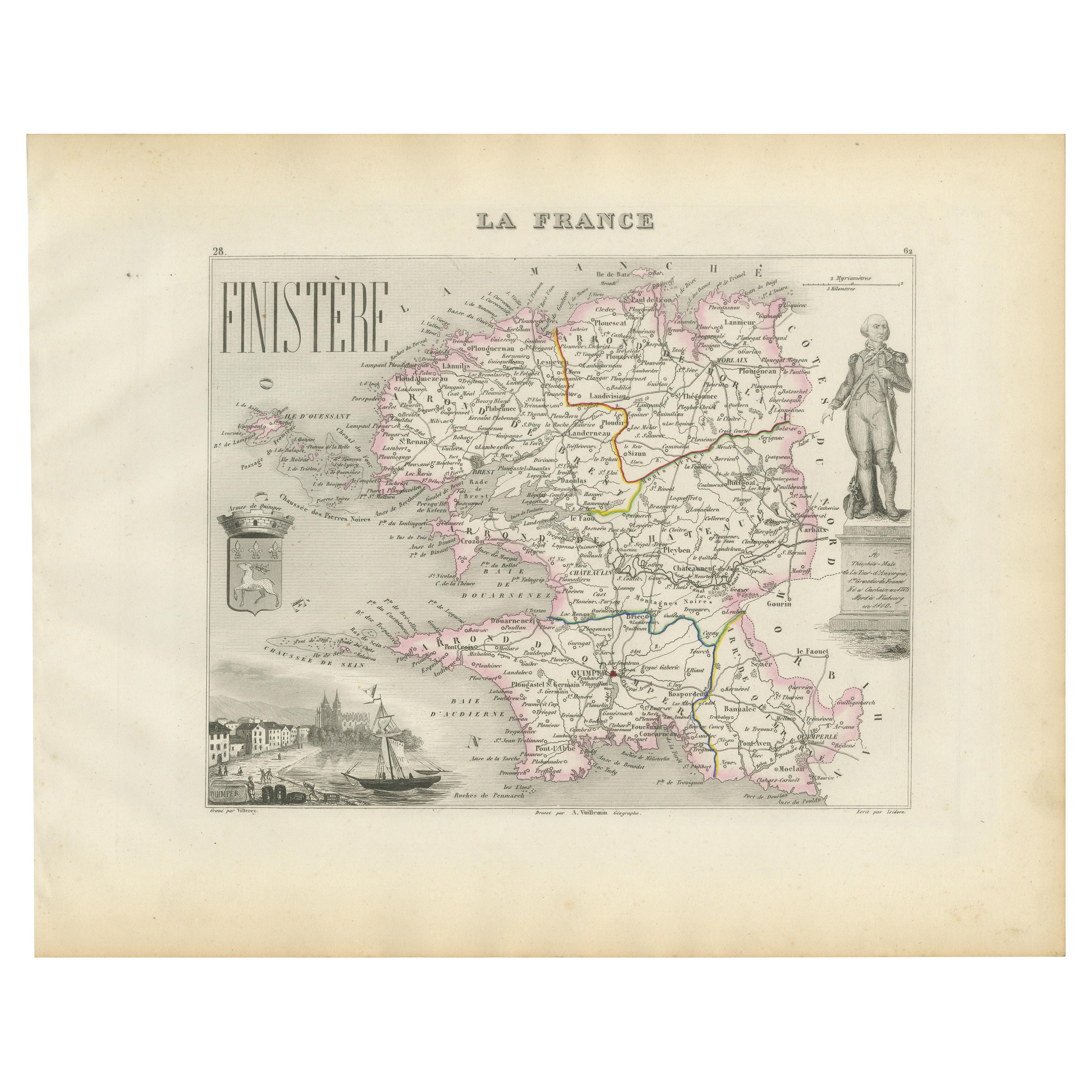
View AllMap of Finistère France with Brest, Quimper and Brittany Coastline, 19th Century
Located in Langweer, NL
Map of Finistère France with Brest, Quimper and Brittany Coastline, 19th Century
Description:
This richly engraved 19th-century map of Finistère, the westernmost department of mainl...
Category
Antique Mid-19th Century French Maps
Materials
Paper
Map of Allier France with Saint-Pourçain Wine Region by Vuillemin, 19th c
Located in Langweer, NL
Map of Allier France with Saint-Pourçain Wine Region by Vuillemin, 19th c
This decorative 19th-century map of Allier, a central department of France, comes from the celebrated Nouve...
Category
Antique Mid-19th Century French Maps
Materials
Paper

Map of Côte-d'Or France with Dijon and Burgundy Wine Region, 19th Century
Located in Langweer, NL
Map of Côte-d'Or France with Dijon and Burgundy Wine Region, 19th Century
Description:
This beautifully engraved 19th-century map of Côte-d'Or, located in the historic region of Bur...
Category
Antique Mid-19th Century French Maps
Materials
Paper

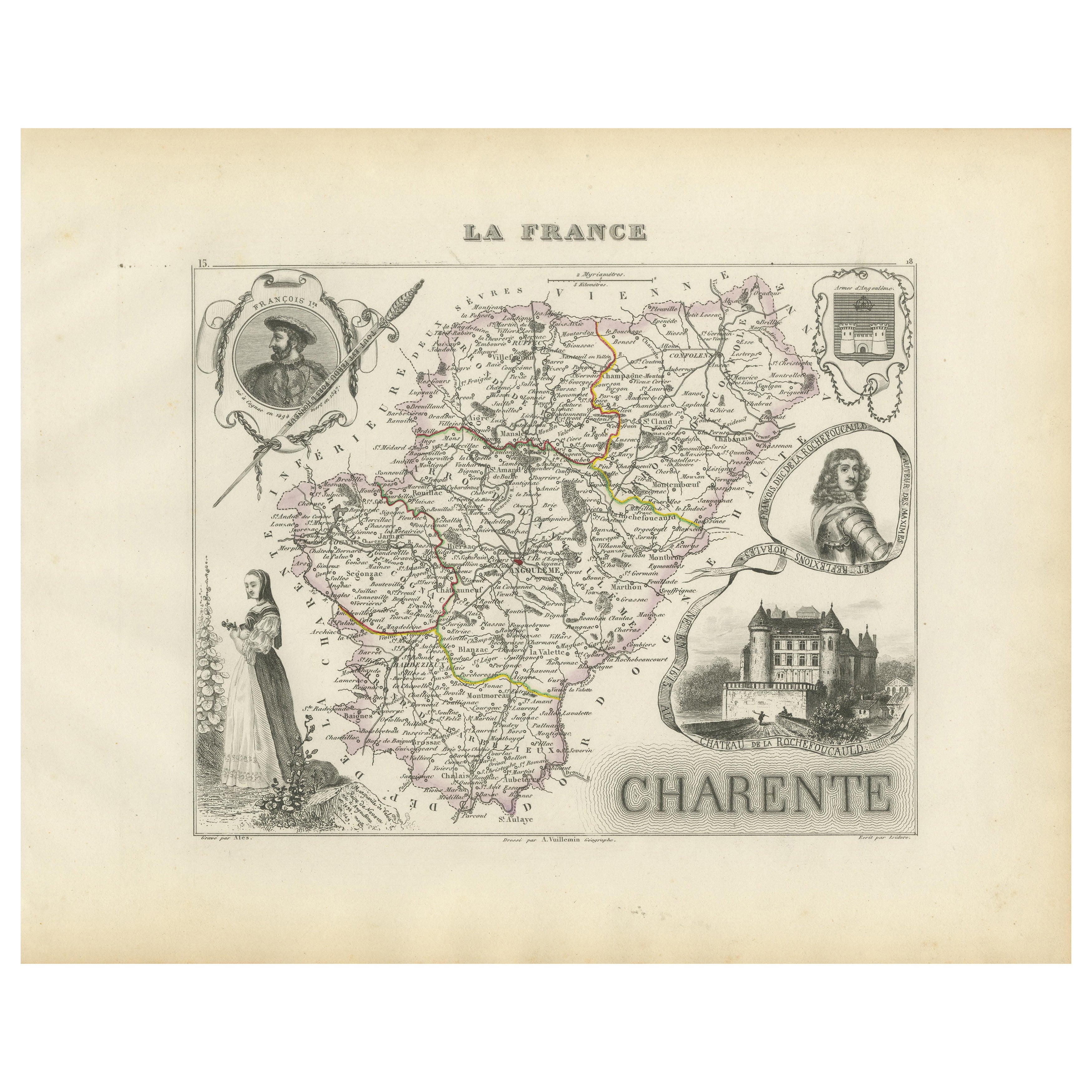
Map of Charente France with Cognac Region and Château de La Rochefoucauld, 1850
Located in Langweer, NL
Map of Charente France with Cognac Region and Château de La Rochefoucauld, 19th c
Description:
This richly illustrated 19th-century map of the Charente department in southwestern Fr...
Category
Antique Mid-19th Century French Maps
Materials
Paper

Map of Ain France with Vineyards of Bugey and Notable Portraits, c.1850
Located in Langweer, NL
Map of Ain France with Portraits of Bichat and Joubert by Vuillemin, 19th c
This highly decorative 19th-century map of the French department of Ain is taken from the celebrated Nouv...
Category
Antique Mid-19th Century French Maps
Materials
Paper

Map of Ariège France with Foix and Pyrenees Landscape by Vuillemin, 19th c
Located in Langweer, NL
Map of Ariège France with Foix and Pyrenees Landscape by Vuillemin, 19th c
Description:
This beautifully detailed 19th-century map of the Ariège department in southwestern France wa...
Category
Antique Mid-19th Century French Maps
Materials
Paper

You May Also Like
Indre and Loire, France. Antique map of a French department, 1856
By Victor Levasseur
Located in Melbourne, Victoria
'Dept. d'Indre et Loire', steel engraving with original outline hand-colouring., 1856, from Levasseur's 'Atlas National Illustre'.
This area is known for its production of Chenin b...
Category
19th Century Naturalistic Landscape Prints
Materials
Engraving

Large 19th Century Map of France
Located in Pease pottage, West Sussex
Large 19th Century Map of France.
Remarkable condition, with a pleasing age worn patina.
Recently framed.
France Circa 1874.
Category
Antique Late 19th Century French Maps
Materials
Linen, Paper

Lozere, France. Antique map of a French department, 1856
By Victor Levasseur
Located in Melbourne, Victoria
'Dept. de La Lozere', steel engraving with original outline hand-colouring., 1856, from Levasseur's 'Atlas National Illustre'.
This remote mountainous part of Languedoc is rural, s...
Category
19th Century Naturalistic Landscape Prints
Materials
Engraving

Var, France. Antique map of a French department, 1856
By Victor Levasseur
Located in Melbourne, Victoria
'Dept. du Var', steel engraving with original outline hand-colouring., 1856, from Levasseur's Atlas National Illustre.
Var covers the heart of the French Riviera or Cote d'Azur., and includes the resort cities of Cannes, Nice and San Tropez...
Category
19th Century Naturalistic Landscape Prints
Materials
Engraving

Saone and Loire, France. Antique map of a French department, 1856
By Victor Levasseur
Located in Melbourne, Victoria
'Dept. de Saone et Loire', steel engraving with original outline hand-colouring., 1856, from Levasseur's Atlas National Illustre.
The French department of Saone et Loire is at the ...
Category
19th Century Naturalistic Landscape Prints
Materials
Engraving

1771 Bonne Map of Poitou, Touraine and Anjou, France, Ric.a015
Located in Norton, MA
1771 Bonne Map of Poitou,
Touraine and Anjou, France
Ric.a015
1771 Bonne map of Potiou, Touraine and Anjou entitled "Carte des Gouvernements D'Anjou et du Saumurois, de la Touraine, du Poitou,du Pays d'aunis, Saintonge?Angoumois,"
Carte des gouvernements d'Anjou et du Saumurois, de la Touraine, du Poitou, du Pays d'Aunis, Saintonge-Angoumois. Projettee et assujettie au ciel par M. Bonne, Hyd. du Roi. A Paris, Chez Lattre, rue St. Jacques a la Ville de Bord(ea)ux. Avec priv. du Roi. 1771. Arrivet inv. & sculp., Atlas moderne ou collection de cartes sur toutes...
Category
Antique 17th Century Unknown Maps
Materials
Paper

More Ways To Browse
Cote France
Antique Brittany
French Brittany Furniture
Brittany Furniture
Antique Village Soft
Brittany Antique Furniture
French Wine Map
Antique Breton Furniture
Antique Furniture From Brittany France
Antique Wine Labels
Antique Fishing Collectables
Pink Wine Glass
Catholic Priest
Celtic Cross
Nouvel Glass
Antique Religious Banner
Religious Banner
Antique Celtic Cross