Items Similar to Map of Finistère France with Brest, Quimper and Brittany Coastline, 19th Century


Want more images or videos?
Request additional images or videos from the seller
1 of 10
Map of Finistère France with Brest, Quimper and Brittany Coastline, 19th Century
$167.89
£124.89
€140
CA$229.89
A$255.61
CHF 133.46
MX$3,111.38
NOK 1,702.95
SEK 1,595.58
DKK 1,065.74
Shipping
Retrieving quote...The 1stDibs Promise:
Authenticity Guarantee,
Money-Back Guarantee,
24-Hour Cancellation
About the Item
Map of Finistère France with Brest, Quimper and Brittany Coastline, 19th Century
Description:
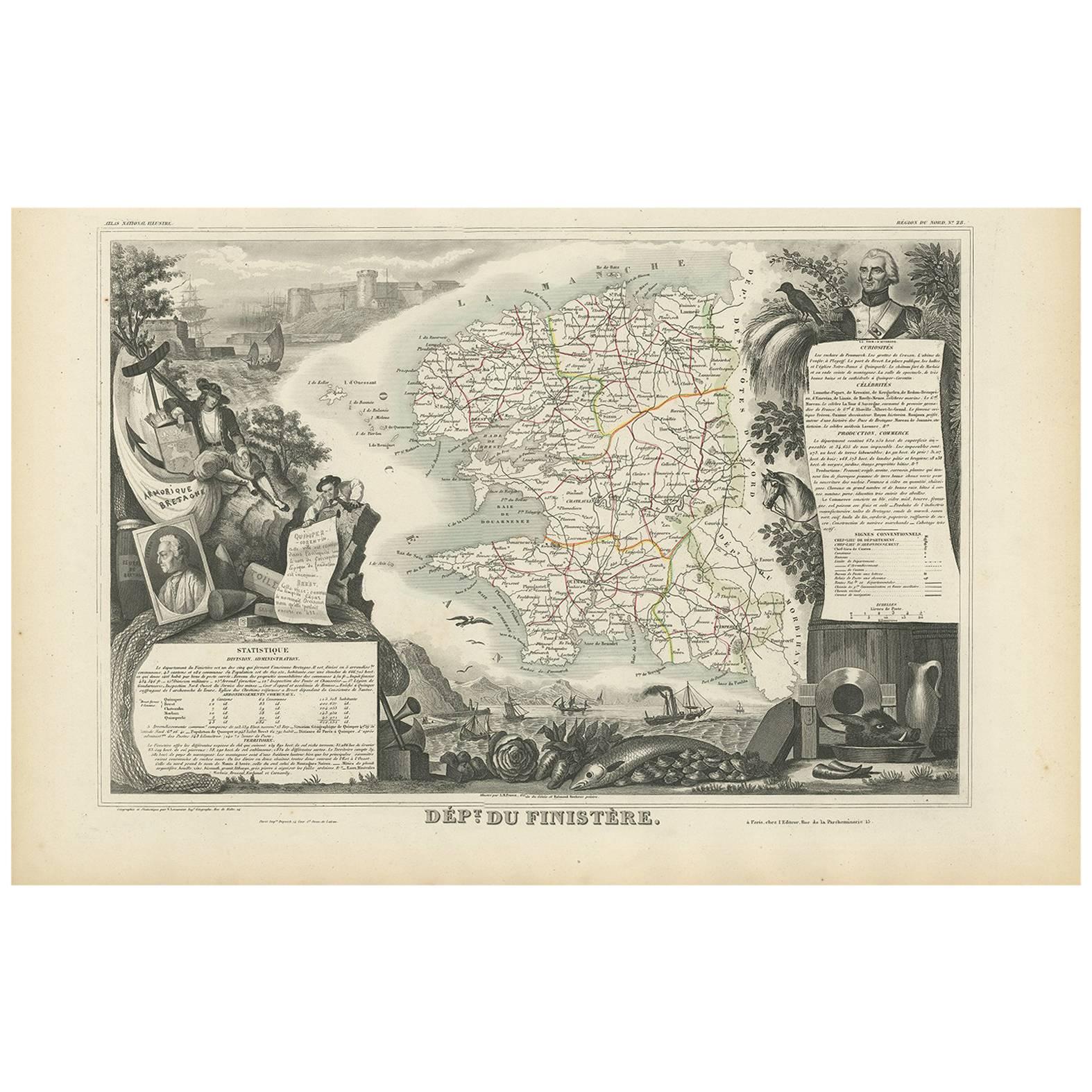
This richly engraved 19th-century map of Finistère, the westernmost department of mainland France, was drawn by Alexandre Vuillemin and published by Migeon in Paris for the *Nouvel Atlas Illustré*. The map offers a finely detailed view of this culturally distinct and geographically dramatic region, renowned for its rugged coastline, maritime heritage, and Celtic traditions.
Finistère, meaning "end of the land" in Latin, is presented here with its departmental boundaries hand-colored in soft pink. The map clearly delineates towns, roads, rivers, and coastal features, including the Crozon Peninsula and islands such as Ouessant and Sein. Quimper, the prefecture, and Brest, a strategic naval base, are prominently marked along with other key towns like Morlaix, Douarnenez, and Concarneau.
In the lower left corner is an engraved vignette of the harbor at Quimper, depicting a sailing vessel, waterfront buildings, and a view of the Gothic cathedral. On the right stands a full-length statue of a revolutionary figure, General Hoche, who led troops in Brittany during the counter-revolutionary uprisings. The top left features the coat of arms of Finistère, bearing a ship and marine imagery appropriate to this seafaring region.
Finistère forms part of Brittany (Bretagne), a region steeped in Celtic culture, Breton language, and maritime history. While not a major wine-producing area, the department is famous for its cider, seafood (especially oysters and scallops), buckwheat galettes, and dairy products. Its coastal geography and strong winds have made it a critical location for lighthouses, fishing ports, and naval defenses for centuries.
This antique map is both decorative and historically informative, ideal for collectors interested in Brittany, French maritime history, or regional ethnography. It reflects the cultural independence and dramatic geography of France’s far western frontier.
Condition summary:
Very good condition with minor age toning and light foxing near the edges. Engraved lines are crisp and the original hand coloring remains clean and consistent.
Framing tips:
A rustic oak or driftwood frame complements the coastal and Breton character of the map. A cream or light gray mat enhances the engraving and soft pink tones. UV-protective glass is recommended for preservation and clarity.
- Dimensions:Height: 12.8 in (32.5 cm)Width: 10.28 in (26.1 cm)Depth: 0.01 in (0.2 mm)
- Materials and Techniques:Paper,Engraved
- Place of Origin:
- Period:
- Date of Manufacture:circa 1850
- Condition:Very good condition with minor age toning and light foxing near the edges. Engraved lines are crisp and the original hand coloring remains clean and consistent.
- Seller Location:Langweer, NL
- Reference Number:Seller: BG-13331-281stDibs: LU3054345363902
About the Seller
5.0
Recognized Seller
These prestigious sellers are industry leaders and represent the highest echelon for item quality and design.
Platinum Seller
Premium sellers with a 4.7+ rating and 24-hour response times
Established in 2009
1stDibs seller since 2017
2,510 sales on 1stDibs
Typical response time: <1 hour
- ShippingRetrieving quote...Shipping from: Langweer, Netherlands
- Return Policy
Authenticity Guarantee
In the unlikely event there’s an issue with an item’s authenticity, contact us within 1 year for a full refund. DetailsMoney-Back Guarantee
If your item is not as described, is damaged in transit, or does not arrive, contact us within 7 days for a full refund. Details24-Hour Cancellation
You have a 24-hour grace period in which to reconsider your purchase, with no questions asked.Vetted Professional Sellers
Our world-class sellers must adhere to strict standards for service and quality, maintaining the integrity of our listings.Price-Match Guarantee
If you find that a seller listed the same item for a lower price elsewhere, we’ll match it.Trusted Global Delivery
Our best-in-class carrier network provides specialized shipping options worldwide, including custom delivery.More From This Seller
View AllMap of Côtes-du-Nord France with Saint-Brieuc and Brittany Coastline, c.1850
Located in Langweer, NL
Map of Côtes-du-Nord France with Saint-Brieuc and Brittany Coastline, 19th c
Description:
This elegant 19th-century map of Côtes-du-Nord, the historic name for what is now known as ...
Category
Antique Mid-19th Century French Maps
Materials
Paper

Antique Map of Finistère ‘France’ by V. Levasseur, 1854
By Victor Levasseur
Located in Langweer, NL
Antique map titled 'Dépt. du Finistère'. Map of the French department of Finistère, Brittany, France. This area of France is known for its cider production and excellent boar hunting...
Category
Antique Mid-19th Century Maps
Materials
Paper
$172 Sale Price
20% Off
Map of Allier France with Saint-Pourçain Wine Region by Vuillemin, 19th c
Located in Langweer, NL
Map of Allier France with Saint-Pourçain Wine Region by Vuillemin, 19th c
This decorative 19th-century map of Allier, a central department of France, comes from the celebrated Nouve...
Category
Antique Mid-19th Century French Maps
Materials
Paper

Map of Aisne France with Soissons and Champagne Vineyards by Vuillemin, 19th c
Located in Langweer, NL
Map of Aisne France with Soissons and Champagne Vineyards by Vuillemin, 19th c
Description:
This richly detailed 19th-century engraved and hand-colored map of the department of Aisn...
Category
Antique Mid-19th Century French Maps
Materials
Paper

Map of Gard France with Pont du Gard and Wine Regions by Vuillemin, 19th c
Located in Langweer, NL
Title: Map of Gard France with Pont du Gard and Wine Regions by Vuillemin, 19th c
Description:
This finely engraved 19th-century map of the department of Gard in southern France was...
Category
Antique Mid-19th Century French Maps
Materials
Paper

Antique Map of France, 1903, with Inset of Paris and Corsica
Located in Langweer, NL
Title: Antique Map of France, 1903, with Inset of Paris and Corsica
Description:
This antique map, titled "France," was engraved and published in 1903 by the renowned W. & A.K. John...
Category
Early 20th Century Maps
Materials
Paper

You May Also Like
Large 19th Century Map of France
Located in Pease pottage, West Sussex
Large 19th Century Map of France.
Remarkable condition, with a pleasing age worn patina.
Recently framed.
France Circa 1874.
Category
Antique Late 19th Century French Maps
Materials
Linen, Paper

The Normandy Region of France: A 17th C. Hand-colored Map by Sanson and Jaillot
By Nicolas Sanson
Located in Alamo, CA
This large hand-colored map entitled "Le Duché et Gouvernement de Normandie divisée en Haute et Basse Normandie en divers Pays; et par evêchez, avec le Gouvernement General du Havre ...
Category
Antique 1690s French Maps
Materials
Paper

Map of France - Etching - 1820
Located in Roma, IT
Map of France is an Original Etching realized by an unknown artist of 19th century in 1820.
Very good condition on two sheets of white paper joined at t...
Category
1820s Modern Figurative Prints
Materials
Etching

France, Northern Part. Century Atlas antique map
Located in Melbourne, Victoria
'The Century Atlas. France, Northern Part.'
Original antique map, 1903.
Inset maps of 'France in Provinces' and 'Paris and Vicinity'.
Central fold as issued. Map name and number pr...
Category
Early 20th Century Victorian More Prints
Materials
Lithograph

Indre and Loire, France. Antique map of a French department, 1856
By Victor Levasseur
Located in Melbourne, Victoria
'Dept. d'Indre et Loire', steel engraving with original outline hand-colouring., 1856, from Levasseur's 'Atlas National Illustre'.
This area is known for its production of Chenin b...
Category
19th Century Naturalistic Landscape Prints
Materials
Engraving

La Gironde, France. Antique map of a French department, 1856
By Victor Levasseur
Located in Melbourne, Victoria
'La Gironde', steel engraving with original outline hand-colouring., 1856, from Levasseur's 'Atlas National Illustre'.
This coastal department is the seat of the Bordeaux wine regi...
Category
19th Century Naturalistic Landscape Prints
Materials
Engraving

More Ways To Browse
Antique Brittany
French Brittany Furniture
Brittany Furniture
Oyster Light
Gothic Cathedral
Brittany Antique Furniture
Antique Cathedral Glass
Sailing Ship 19th Century
French Wine Map
Lighthouse Antique
Antique Breton Furniture
Antique Quimper
Island Counter
Gothic Engraving
Antique Oak Island
Colored Wine Glass
Port Wine
Antique French Counter