Items Similar to Map of Florida, Louisiana and the Bahamas – Set of Rare French Sea Charts, 1777


Want more images or videos?
Request additional images or videos from the seller
1 of 15
Map of Florida, Louisiana and the Bahamas – Set of Rare French Sea Charts, 1777
$3,418.01per set
£2,574.44per set
€2,900per set
CA$4,713.58per set
A$5,295.49per set
CHF 2,766.90per set
MX$64,633.96per set
NOK 35,131.58per set
SEK 33,068.98per set
DKK 22,073.70per set
About the Item
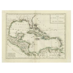
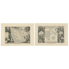
1777 Le Rouge Map of Florida, Louisiana, and the Bahamas. Lot of 2 large maps: "Carte de la Floride Occidentale et Louisiane & La Peninsule et Golfe de la Floride"
This rare and important two-sheet map by George Louis Le Rouge, titled "Carte de la Floride Occidentale et Louisiane" and "La Peninsule et Golfe de la Floride ou Canal de Bahama avec les Isles de Bahama," was originally published in 1777 as part of Le Rouge's "Pilote Americain Septentrional."
Derived from Jeffrey's "The West Indian Atlas" (1775), these charts offer one of the earliest accurate depictions of Florida, the Bahamas, and the Gulf Coast, extending west to Cabo del Norte in Louisiana.
This set of two beautifully hand-colored 18th-century nautical maps offers a fascinating glimpse into the colonial geography of the Gulf of Mexico and the Caribbean. Rich in historical and cartographic value, these prints illustrate the strategic importance of the southeastern coast of North America during the age of exploration and colonial expansion.
The first map focuses on the northern Gulf Coast, showing the regions of Louisiana and Western Florida. It includes the Mississippi Delta, Mobile Bay, Pensacola, and stretches westward along the coast into present-day Texas. The detailed hydrography, including sandbanks, inlets, islands, and soundings, reflects the map’s maritime purpose, essential for navigation. The inclusion of sailing ships and a large, colorful compass rose enhances both its visual and thematic appeal. The area was a contested zone between Spanish, French, and later British colonial powers, making this map a valuable document of early American and colonial Gulf history.
The second map highlights Eastern Florida and the Bahamas, with exceptional detail given to the coastline, reefs, and islands. It includes a remarkably detailed outline of the Florida Peninsula, the Bahamas archipelago, and part of Cuba. The naming of native territories, coastal settlements, and navigational hazards, such as shoals and banks, reflects the seafaring focus of the cartographer. This map captures the crucial importance of the Florida Channel and the Bahama Banks, areas frequently navigated by European trading fleets. The fine calligraphy, elegant engraving, and artistic flourishes such as sea monsters and sailing vessels add to its historical charm.
Together, these maps provide an extraordinary cartographic record of colonial ambitions, trade routes, and naval exploration in the New World. They would be of great interest to collectors of maritime history, antique maps, or Americana.
Condition Report:
Both prints are in fine condition with only very minor age-related toning to the edges. The hand coloring remains vibrant and well-preserved. Crisp impression with attractive hand coloring, printed on watermarked paper. A few short edge tears, none of which intrude into the image area. Overall, the sheets are well-preserved, with excellent color retention and clear, legible labeling. Plate marks are clear, and the paper is strong with ample margins.
Framing Suggestions:
To enhance their visual and historical presence, consider framing these maps in complementary antique-style wooden frames, perhaps with a gold or dark walnut finish. A neutral or slightly ivory-colored mat will help draw focus to the detailed engravings. Museum-grade UV-protective glass is recommended to preserve the colors and paper quality. Displayed side by side, they form a striking historical panorama of the southeastern seaboard and Caribbean.
- Dimensions:Height: 18.9 in (48 cm)Width: 24.22 in (61.5 cm)Depth: 0.01 in (0.2 mm)
- Sold As:Set of 2
- Materials and Techniques:Paper,Engraved
- Period:1770-1779
- Date of Manufacture:1777
- Condition:Repaired: The eastern sheet has undergone archival repairs to address a chip in the top blank margin. Crisp impression with attractive hand coloring, printed on watermarked paper. A few short edge tears, none of which intrude into the image area. Overall, the sheets are well-preserved, with excellent color retention and clear, legible labeling.
- Seller Location:Langweer, NL
- Reference Number:Seller: BHZ113781stDibs: LU3054342599852
About the Seller
5.0
Recognized Seller
These prestigious sellers are industry leaders and represent the highest echelon for item quality and design.
Platinum Seller
Premium sellers with a 4.7+ rating and 24-hour response times
Established in 2009
1stDibs seller since 2017
2,534 sales on 1stDibs
Typical response time: <1 hour
- ShippingRetrieving quote...Shipping from: Langweer, Netherlands
- Return Policy
Authenticity Guarantee
In the unlikely event there’s an issue with an item’s authenticity, contact us within 1 year for a full refund. DetailsMoney-Back Guarantee
If your item is not as described, is damaged in transit, or does not arrive, contact us within 7 days for a full refund. Details24-Hour Cancellation
You have a 24-hour grace period in which to reconsider your purchase, with no questions asked.Vetted Professional Sellers
Our world-class sellers must adhere to strict standards for service and quality, maintaining the integrity of our listings.Price-Match Guarantee
If you find that a seller listed the same item for a lower price elsewhere, we’ll match it.Trusted Global Delivery
Our best-in-class carrier network provides specialized shipping options worldwide, including custom delivery.More From This Seller
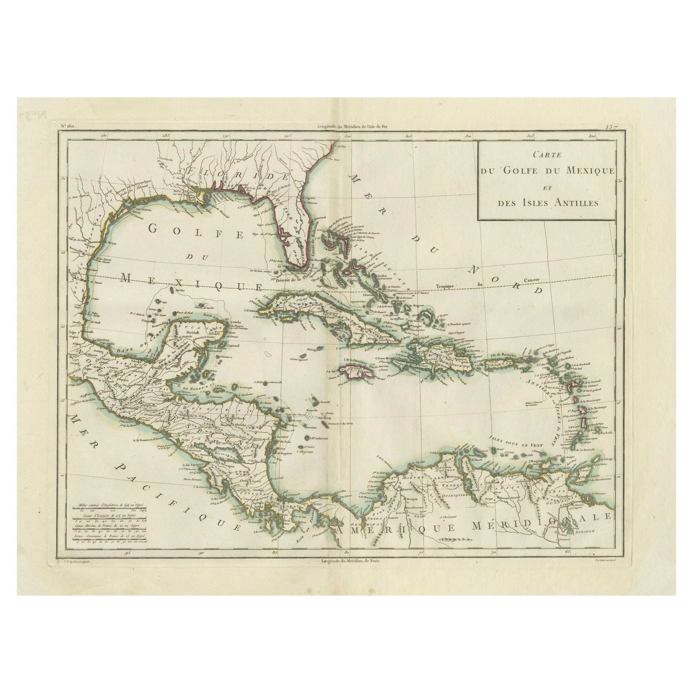
View AllAntique Map of the Gulf of Mexico and Caribbean Islands by Tardieu, 1802
Located in Langweer, NL
This is an original antique map titled "Carte du Golfe du Mexique et des Isles Antilles," depicting the Gulf of Mexico and the Caribbean islands. Created by Pierre Antoine Tardieu, t...
Category
Antique Early 1800s Maps
Materials
Paper
$528 Sale Price
20% Off
Authentic Antique Map of the Caribbean, Gulf Coast and Central America, 1787
Located in Langweer, NL
Antique map titled 'Les Isles Antilles et le Golfe du Méxique'. Original old map of the Caribbean, Gulf Coast and Central America. With inset map of Bermuda...
Category
Antique Late 18th Century Maps
Materials
Paper

$292 Sale Price
20% Off
Free Shipping
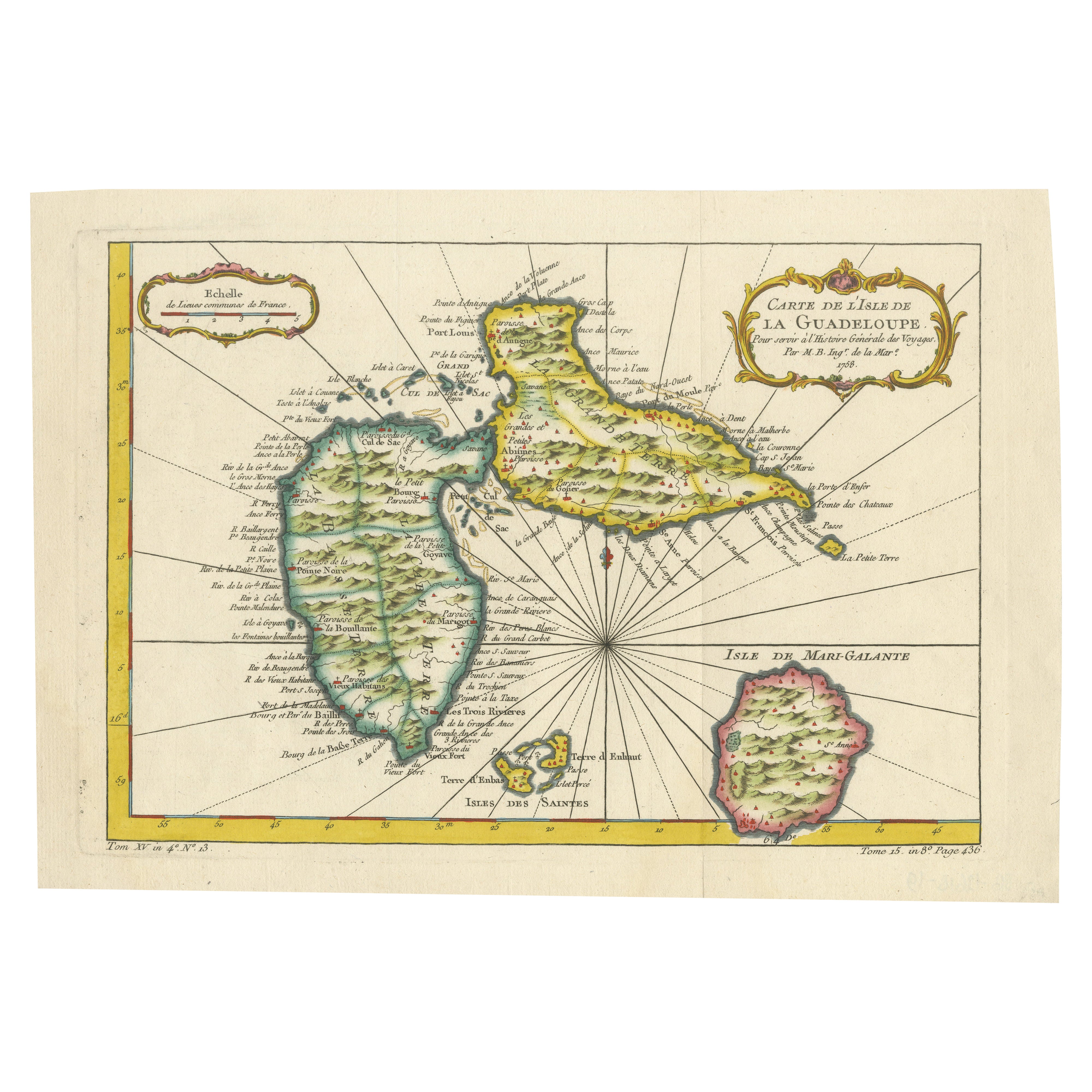
1758 Bellin Map of Guadeloupe and Marie-Galante – Caribbean Islands
Located in Langweer, NL
Thank you for noting the correct date on the map. Here is your **updated plain text catalog listing**:
---
**Title (under 80 characters):**
1758 Bellin Map of Guadeloupe and Marie-Galante – Caribbean Islands
**Description:**
Original antique map titled *Carte de l’Isle de la Guadeloupe* by Jacques Nicolas Bellin, engraved for the *Histoire Générale des Voyages*, published in Paris in 1758.
This finely engraved copperplate map depicts the French Caribbean island of Guadeloupe, showing its distinctive butterfly-shaped division into Basse-Terre and Grande-Terre. The surrounding smaller islands include Marie-Galante (bottom right) and Les Saintes. The map details numerous place names, parishes, rivers, bays, mountains, and anchorages. A decorative rococo title cartouche graces the upper right corner, complemented by a scale bar cartouche in the upper left.
Jacques Nicolas Bellin (1703-1772) served as Hydrographer to the King and was one of the most prominent French cartographers of the 18th century, producing maps noted for their accuracy, elegance, and clarity. This map was created for the influential *Histoire Générale des Voyages* by Abbé Prévost.
Condition report:
Excellent condition. Strong and clean impression on fine laid paper with wide margins. Original hand coloring in outline and wash, highlighting coastlines and cartouches. Minor age toning at edges; verso blank.
Framing suggestion:
Frame with a classic gold or dark wood moulding and a neutral cream archival mat to emphasize the fine engraving and delicate color washes. Museum glass is recommended to preserve this 18th-century Caribbean map...
Category
Antique Mid-18th Century French Maps
Materials
Paper

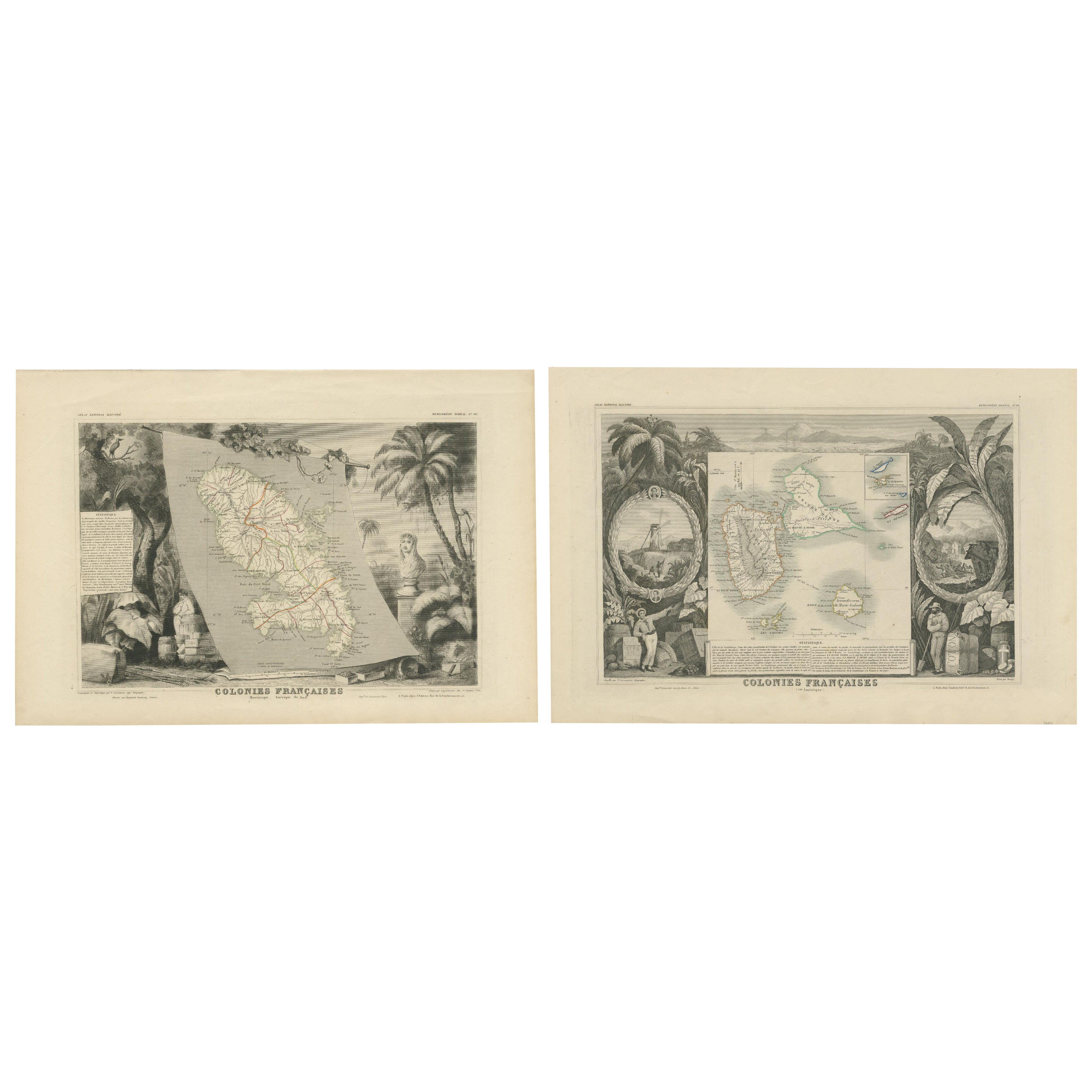
French Colonies in the Caribbean: Maps of Martinique and Guadeloupe (1852)
Located in Langweer, NL
This pair of maps, published in 1852, provides a detailed representation of the French Caribbean colonies, specifically Martinique and Guadeloupe. They were part of the *Atlas Univer...
Category
Antique 1850s Maps
Materials
Paper
$311 Sale Price / set
20% Off
Antique Map of South America by J. Cook, 1775
Located in Langweer, NL
Antique map titled 'Kaart van het Zuidlyk Eind van Amerika'. Map of the sourthern part of South America, focusing on Cook's tracks around the Cape Horn and T...
Category
Antique Mid-18th Century Maps
Materials
Paper

$801 Sale Price
20% Off
Antique Map of South America by J. Cook (1775)
Located in Langweer, NL
Antique map titled 'Kaart van het Zuidlyk Eind van Amerika'. Map of the sourthern part of South America, focusing on Cook's tracks around the Cape Horn and Tierra del Fuego in 1775. ...
Category
Antique Late 18th Century Maps
Materials
Paper

$557 Sale Price
20% Off
You May Also Like
Original Antique Map of Central America / Florida, Arrowsmith, 1820
Located in St Annes, Lancashire
Great map of Central America.
Drawn under the direction of Arrowsmith.
Copper-plate engraving.
Published by Longman, Hurst, Rees, Orme and Brown, 1820
Unframed.
Category
Antique 1820s English Maps
Materials
Paper

California: 18th Century Hand-colored Map by de Vaugondy
By Didier Robert de Vaugondy
Located in Alamo, CA
This is an 18th century hand-colored map of the western portions of North America entitled "Carte de la Californie et des Pays Nord-Ouest separés de l'Asie par le détroit d'Anian, ex...
Category
1770s Landscape Prints
Materials
Engraving

Original Antique Map of South America. C.1780
Located in St Annes, Lancashire
Great map of South America
Copper-plate engraving
Published C.1780
Two small worm holes to left side of map
Unframed.
Category
Antique Early 1800s English Georgian Maps
Materials
Paper

Original Antique Map of The World by Thomas Clerk, 1817
Located in St Annes, Lancashire
Great map of The Eastern and Western Hemispheres
On 2 sheets
Copper-plate engraving
Drawn and engraved by Thomas Clerk, Edinburgh.
Published by Mackenzie And Dent, 1817
...
Category
Antique 1810s English Maps
Materials
Paper

Antique Map of the Southern Oceans, South America and Africa
Located in New York, NY
Antique Map of the South Atlantic, c. 1800s
Engraving
20 x 28 in.
Framed: 25 3/4 x 33 3/4 in.
Category
19th Century Realist Figurative Prints
Materials
Engraving
Antique 1765 Wine Country Folding Map of France, Bordeau etc.
Located in Paonia, CO
Route du Carosse de Bordeaux, part de Paris tous les Mardis a 11 matin. a et pafse 1765 is a comprehensive map with two routes through the wine country of France starting in Paris going south...
Category
1760s Other Art Style Landscape Prints
Materials
Etching

More Ways To Browse
Used Furniture Florida
Antique Compasses
Antique Mobiles
Antique Ivory Collectables
Louisiana Furniture
Louisiana Antique Furniture
Fleet Furniture Antique
Antique Glass Bank
Louisiana Antiques
Sea Monster
Used Furniture North Bay
Wooden Compass
18th Century Naval
Antique Mexican Plates
Bahamas Furniture
British Compass
Gold Charms Nautical
Antique Gold Compass