Items Similar to Authentic Antique Map of the Caribbean, Gulf Coast and Central America, 1787


Want more images or videos?
Request additional images or videos from the seller
1 of 10
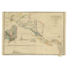
Authentic Antique Map of the Caribbean, Gulf Coast and Central America, 1787
About the Item
Antique map titled 'Les Isles Antilles et le Golfe du Méxique'. Original old map of the Caribbean, Gulf Coast and Central America. With inset map of Bermuda. Originates from 'Histoire Philosopgique et Politique des Establissements et du Commerce des Europeens (..)' by R. Bonne. Published 1787.
Rigobert Bonne (1727-1794) was an influential French cartographer of the late-eighteenth century. Born in the Lorraine region of France, Bonne came to Paris to study and practice cartography. He was a skilled cartographer and hydrographer and succeeded Jacques Nicolas Bellin as Royal Hydrographer at the Depot de la Marine in 1773. He published many charts for the Depot, including some of those for the Atlas Maritime of 1762. In addition to his work at the Depot, he is best known for his work on the maps of the Atlas Encyclopedique (1788) which he did with Nicholas Desmarest.
There are several aspects that make this antique map particularly special:
1. **Historical Significance**: The map originates from "Histoire Philosopgique et Politique des Establissements et du Commerce des Europeens" by R. Bonne, published in 1787. This means it is over two centuries old, providing a valuable glimpse into the geographical knowledge and understanding of the Caribbean, Gulf Coast, and Central America during the late 18th century.
2. **Cartographic Detail**: Rigobert Bonne was a skilled French cartographer known for his accuracy and attention to detail. His maps are renowned for their precision and clarity, making them not only aesthetically pleasing but also valuable historical documents.
3. **Scope and Coverage**: The map covers a wide geographic area, including the Caribbean islands, the Gulf Coast of North America, and parts of Central America. Such comprehensive coverage would have been particularly valuable to navigators, explorers, and traders of the time.
4. **Inset Map of Bermuda**: The inclusion of an inset map of Bermuda adds to the map's appeal and utility, providing additional detail for a specific region of interest.
5. **Association with R. Bonne**: Rigobert Bonne's contributions to cartography, including his role as Royal Hydrographer, and his collaborations with other notable cartographers like Nicolas Desmarest, add to the map's significance and collectability.
6. **Artistic and Aesthetic Value**: Beyond its practical utility, antique maps are often appreciated for their artistic qualities, including elaborate decorative elements, ornate cartouches, and vibrant coloration.
Overall, the combination of historical context, cartographic excellence, and the map's association with a renowned cartographer like R. Bonne contributes to its special status among collectors, historians, and enthusiasts of antique maps and cartography.
- Dimensions:Height: 10.52 in (26.7 cm)Width: 16.38 in (41.6 cm)Depth: 0.02 in (0.5 mm)
- Materials and Techniques:
- Period:
- Date of Manufacture:1787
- Condition:Age-related toning. Original folding line. Blank verso. Please study image carefully.
- Seller Location:Langweer, NL
- Reference Number:
About the Seller
5.0
Platinum Seller
These expertly vetted sellers are 1stDibs' most experienced sellers and are rated highest by our customers.
Established in 2009
1stDibs seller since 2017
1,919 sales on 1stDibs
Typical response time: <1 hour
- ShippingRetrieving quote...Ships From: Langweer, Netherlands
- Return PolicyA return for this item may be initiated within 14 days of delivery.
More From This SellerView All
- Engraving of a Map of Florida, the Gulf Coast, Caribbean & Central America, 1728Located in Langweer, NLThis exceptional antique map, titled "Nouvelle Carte Marine de Toute les Cotes de l´Amerique" and alternatively known as "Nieuwe groote en seer Curieuse Paskaart van Geheel-WestIndie...Category
Antique Mid-18th Century European Maps
MaterialsPaper
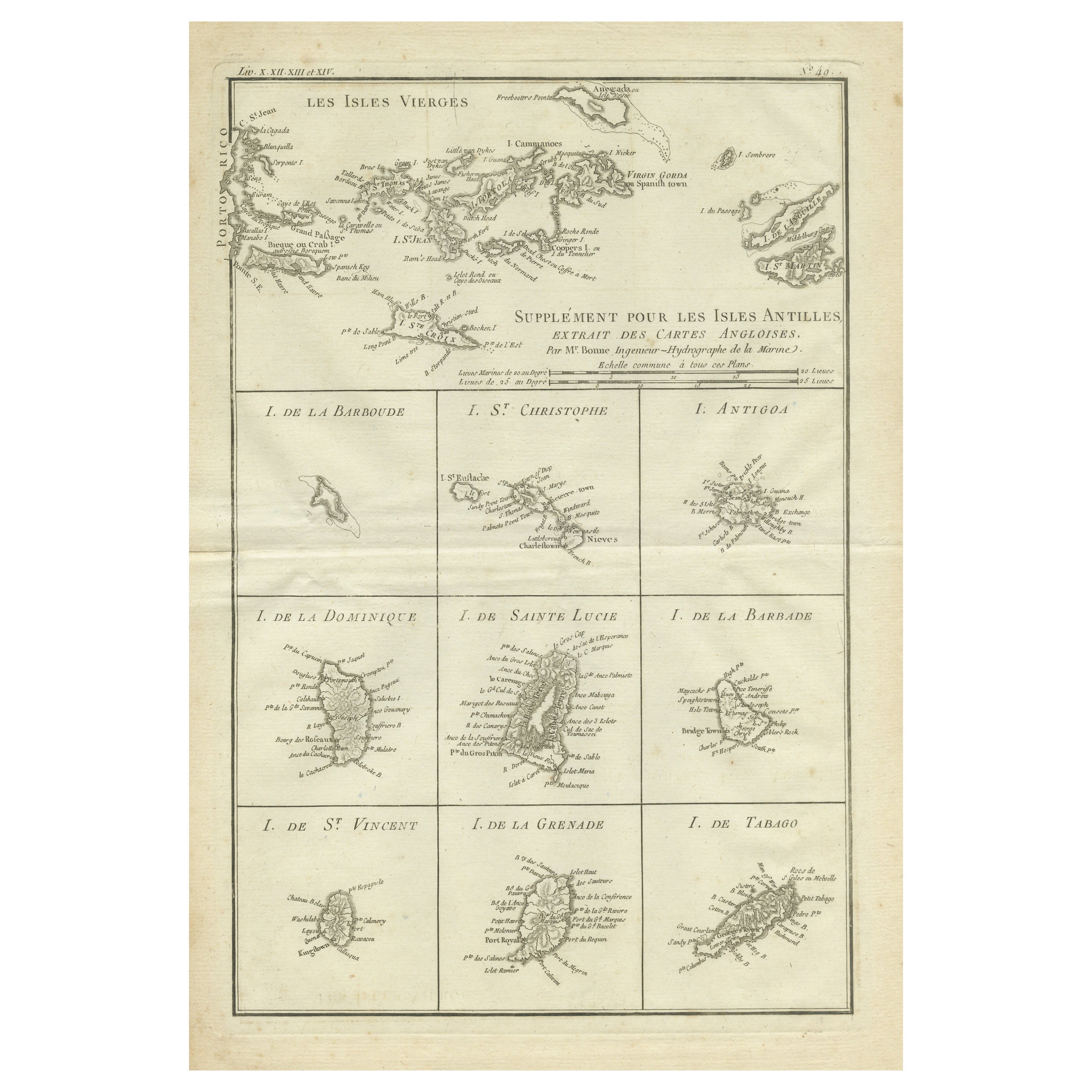
- Original Antique Map of the Virgin Islands with Insets of Caribbean Isles, 1787Located in Langweer, NLAntique map titled 'Supplément pour les Isles Antilles (..)'. Original old map of the Virgin Islands, with insets of Barbuda, St. Kits, Antigua, Dominica, St. Lucia, Barbados, St. Vi...Category
Antique Late 18th Century Maps
MaterialsPaper
- Antique Map of Central America and the West Indies, 1882Located in Langweer, NLAntique map titled 'West India Islands and Central America'. Old map of Central America and the West Indies. This map originates from 'The Royal Atlas of Modern Geography, Exhibiting...Category
Antique 19th Century Maps
MaterialsPaper
- Antique Map of the United States of America, also showing the CaribbeanLocated in Langweer, NLAntique map titled 'Verein-Staaten von Nord-America, Mexico, Yucatan u.a.'. Very detailed map of the United States of America showing the ...Category
Antique Mid-19th Century Maps
MaterialsPaper
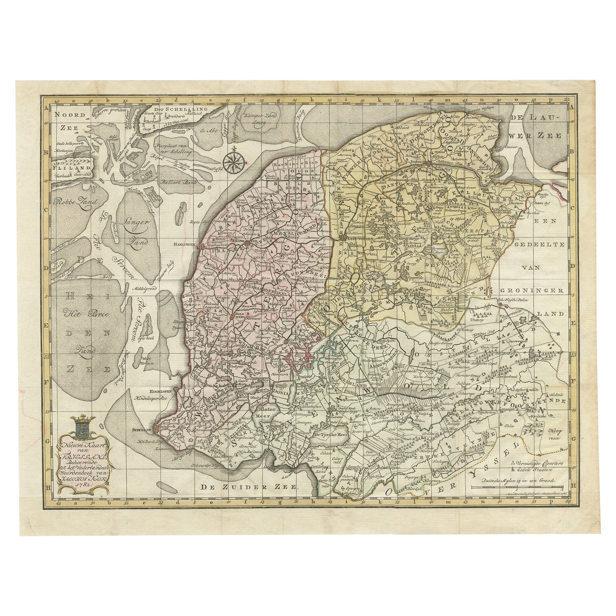
- Antique Map of Province Friesland, The Netherlands, 1787Located in Langweer, NLAntique map titled 'Nieuwe Kaart van Friesland behoorende tot het Vaderlandsch Woordenboek van Jacobus Kok'. Original antique map of the province of Friesland, the Netherlands. This ...Category
Antique 18th Century Maps
MaterialsPaper
- Antique Map of Central America Showing the Communication Lines, 1850Located in Langweer, NLAntique map titled 'Map of Central America Shewing the Different Lines of Atlantic & Pacific Communication'. A most unusual U.S. Government edition of this handsome map of Central Am...Category
Antique 19th Century Maps
MaterialsPaper


You May Also Like
- Original Antique Map of Ancient Greece, Phocis, Gulf of Corinth, 1787Located in St Annes, LancashireGreat map of Ancient Greece. Showing the region of Phocis, including the Gulf of Corinth Drawn by J.D. Barbie Du Bocage Copper plate engraving by P.F Tardieu Original hand c...Category
Antique 1780s French Other Maps
MaterialsPaper
- Original Antique Map of Central America / Florida, Arrowsmith, 1820Located in St Annes, LancashireGreat map of Central America. Drawn under the direction of Arrowsmith. Copper-plate engraving. Published by Longman, Hurst, Rees, Orme and Brown, 1820 Unframed.Category
Antique 1820s English Maps
MaterialsPaper
- Original Antique Map of Ancient Greece- Boeotia, Thebes, 1787Located in St Annes, LancashireGreat map of Ancient Greece. Showing the region of Boeotia, including Thebes Drawn by J.D. Barbie Du Bocage Copper plate engraving by P.F T...Category
Antique 1780s French Other Maps
MaterialsPaper
- Original Antique Decorative Map of South America-West Coast, Fullarton, C.1870Located in St Annes, LancashireGreat map of Chili, Peru and part of Bolivia Wonderful figural border From the celebrated Royal Illustrated Atlas Lithograph. Original color. Published by Fullarton, Edi...Category
Antique 1870s Scottish Maps
MaterialsPaper
- Framed 1838 Mexico & Gulf of Mexico MapLocated in Stamford, CTFramed 1838 Mexico & Gulf of Mexico map. Printed by Fisher, Son & Co. of London in 1838. As found framed condition. Map has not been examined outside of th...Category
Antique 1830s English American Classical Maps
MaterialsGlass, Wood, Paper
- 1899 Poole Brothers Antique Railroad Map of the Illinois Central RailroadLocated in Colorado Springs, COThis is an 1899 railroad map of the Illinois Central and Yazoo and Mississippi Valley Railroads, published by the Poole Brothers. The map focuses on the continuous United States from the Atlantic to the Pacific Oceans, the Gulf of Mexico, and the Antilles. Remarkably detailed, the rail routes of the Illinois Central RR are marked in red, which each stop labeled. Major stops are overprinted in red, bold letters, with the short rail distances to New York listed above the stop and short rail distances to New Orleans listed below the name. In addition to the Illinois Central network, numerous different rail lines are illustrated and the company running that line is noted along with many stops along each route. Sea routes from New Orleans to locations in Central America, the Caribbean, and Europe are marked and labeled with destination and distance, along with routes originating from Havana. Inset at bottom left is a map of Cuba; an inset map of Puerto Rico...Category
Antique 1890s American Maps
MaterialsPaper


