Items Similar to Antique Map of Province Friesland, The Netherlands, 1787


Want more images or videos?
Request additional images or videos from the seller
1 of 5
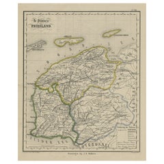
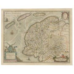
Antique Map of Province Friesland, The Netherlands, 1787
About the Item
Antique map titled 'Nieuwe Kaart van Friesland behoorende tot het Vaderlandsch Woordenboek van Jacobus Kok'. Original antique map of the province of Friesland, the Netherlands. This map originates from 'Vaderlandsch Woordenboek' by Jacobus Kok, published 1787. Artists and Engravers: Published by A. van Krevelt.
Artist: Published by A. van Krevelt.
Condition: Good, original folding lines. Minor wear and creasing. General age-related toning. Small split outside image, blank verso. Please study image carefully.
Date: 1787
Overall size: 46 x 36 cm.
Image size: 42.5 x 32.5 cm.
We sell original antique maps to collectors, historians, educators and interior decorators all over the world. Our collection includes a wide range of authentic antique maps from the 16th to the 20th centuries. Buying and collecting antique maps is a tradition that goes back hundreds of years. Antique maps have proved a richly rewarding investment over the past decade, thanks to a growing appreciation of their unique historical appeal. Today the decorative qualities of antique maps are widely recognized by interior designers who appreciate their beauty and design flexibility. Depending on the individual map, presentation, and context, a rare or antique map can be modern, traditional, abstract, figurative, serious or whimsical. We offer a wide range of authentic antique maps for any budget.
- Dimensions:Height: 14.18 in (36 cm)Width: 18.12 in (46 cm)Depth: 0 in (0.01 mm)
- Materials and Techniques:
- Period:
- Date of Manufacture:1787
- Condition:Condition: Good, original folding lines. Minor wear and creasing. General age-related toning. Small split outside image, blank verso. Please study image carefully.
- Seller Location:Langweer, NL
- Reference Number:
About the Seller
5.0
Platinum Seller
These expertly vetted sellers are 1stDibs' most experienced sellers and are rated highest by our customers.
Established in 2009
1stDibs seller since 2017
1,933 sales on 1stDibs
Typical response time: <1 hour
- ShippingRetrieving quote...Ships From: Langweer, Netherlands
- Return PolicyA return for this item may be initiated within 14 days of delivery.
More From This SellerView All
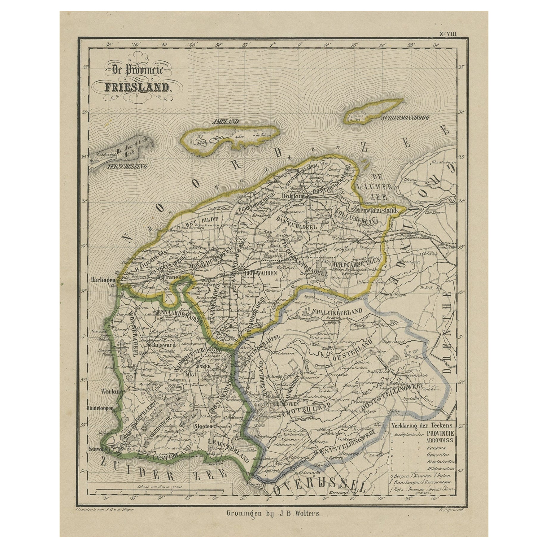
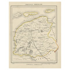
- Antique Map of Friesland, Province in The Netherlands, 1864Located in Langweer, NLAntique map titled 'De Provincie Friesland'. Map of the province of Friesland, the Netherlands. This map originates from 'F. C. Brugsma's Atlas van het Koninkrijk der Nederlanden (.....Category
Antique 19th Century Maps
MaterialsPaper
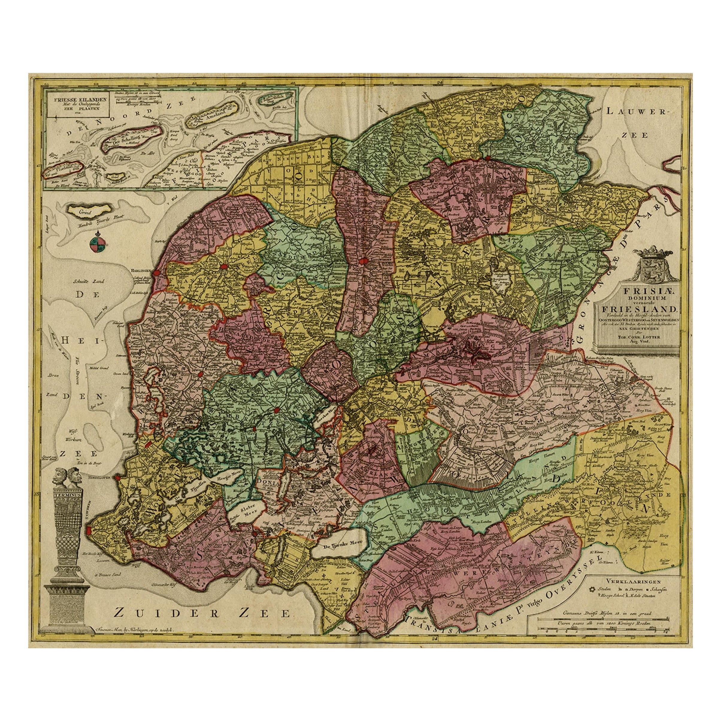
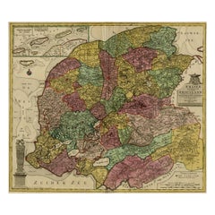
- Antique Map of the Province of Friesland, The Netherlands, c.1760Located in Langweer, NLAntique map titled 'Frisiae Dominium vernacule Friesland, verdeeld in de Hoofd-deelen van Oostergoo, Westergoo en Sevenwolden, Als ook der XI Steden Zynde noch onderscheiden in XXX G...Category
Antique 18th Century Maps
MaterialsPaper
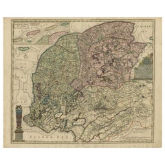
- Antique Map of the Province of Friesland in The Netherlands, 1718Located in Langweer, NLAntique map titled 'Frisiae Dominium vernacule Friesland (..)'. Original antique map of Friesland, the Netherlands. Originates from 'Uitbeelding van de Heerlijkheid van Friesland...Category
Antique 18th Century Maps
MaterialsPaper
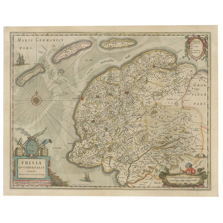
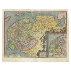
- Old Antique Map of the Province of Friesland, the Netherlands, c.1580Located in Langweer, NLAntique map titled 'Frisia Occidentalis'. Old map of the province of Friesland, the Netherlands. This map is also known as the 'Pauwenkaart' ('peacock map'), referring to the peacock next to the inset map. Based on a manuscript map...Category
Antique 16th Century Maps
MaterialsPaper
- Antique Map of Friesland, The Netherlands, 1638Located in Langweer, NLAntique map titled 'Frisia Occidentalis'. Original antique map of Friesland, the Netherlands. First state, originating from 'Atlantis novi pars secunda' published 1638. Artis...Category
Antique 17th Century Maps
MaterialsPaper
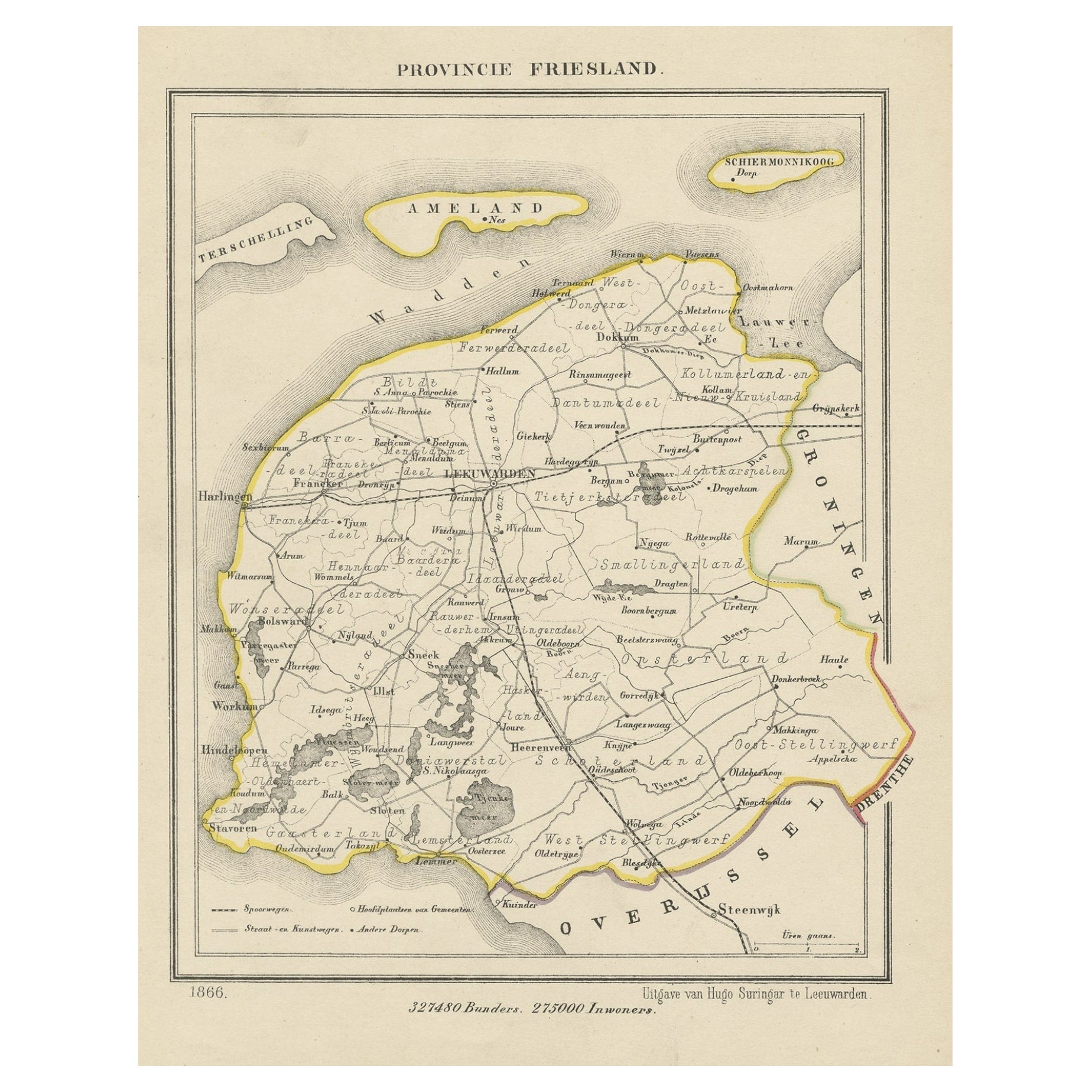
- Antique Print of the Province of Friesland, The Netherlands, 1868Located in Langweer, NLAntique map titled 'Provincie Friesland'. Map of Friesland, the Netherlands. This map originates from 'Gemeente-Atlas van Nederland' by J. Kuyper. Artists and Engravers: Publ...Category
Antique 1860s Maps
MaterialsPaper
You May Also Like
- Antique 18th Century Map of the Province of Pensilvania 'Pennsylvania State'Located in Philadelphia, PAA fine antique of the colony of Pennsylvania. Noted at the top of the sheet as a 'Map of the province of Pensilvania'. This undated and anonymous map is thought to be from the Gentleman's Magazine, London, circa 1775, although the general appearance could date it to the 1760's. The southern boundary reflects the Mason-Dixon survey (1768), the western boundary is placed just west of Pittsburgh, and the northern boundary is not marked. The map has a number of reference points that likely refer to companion text and appear to be connected to boundaries. The western and southern boundaries are marked Q, R, S, for example. A diagonal line runs from the Susquehanna R to the Lake Erie P. A broken line marked by many letters A, B, N, O, etc., appears in the east. There are no latitude or longitude markings, blank verso. Framed in a shaped contemporary gilt wooden frame and matted under a cream colored matte. Bearing an old Graham Arader Gallery...Category
Antique 18th Century British American Colonial Maps
MaterialsPaper
- Original Antique Map of Ancient Greece, Phocis, Gulf of Corinth, 1787Located in St Annes, LancashireGreat map of Ancient Greece. Showing the region of Phocis, including the Gulf of Corinth Drawn by J.D. Barbie Du Bocage Copper plate engraving by P.F Tardieu Original hand c...Category
Antique 1780s French Other Maps
MaterialsPaper
- Original Antique Map of The Netherlands, Sherwood, Neely & Jones, Dated 1809Located in St Annes, LancashireGreat map of The Netherlands Copper-plate engraving by Cooper Published by Sherwood, Neely & Jones. Dated 1809 Unframed.Category
Antique Early 1800s English Maps
MaterialsPaper
- Original Antique Map of The Netherlands, Engraved by Barlow, Dated 1807Located in St Annes, LancashireGreat map of Netherlands Copper-plate engraving by Barlow Published by Brightly & Kinnersly, Bungay, Suffolk. Dated 1807 Unframed.Category
Antique Early 1800s English Maps
MaterialsPaper
- School Chart or Pull Down Map of Geography of the Netherlands, 1950sLocated in Hemiksem, VANA beautiful old school map of the Netherlands, painted on linen. The map shows the 3 different reliefs (low, middle, high) of the Netherlands. The beau...Category
Vintage 1950s Belgian Mid-Century Modern Maps
MaterialsLinen, Paint
- 1861 Topographical Map of the District of Columbia, by Boschke, Antique MapLocated in Colorado Springs, COPresented is an original map of Albert Boschke's extremely sought-after "Topographical Map of the District of Columbia Surveyed in the Years 1856 ...Category
Antique 1860s American Historical Memorabilia
MaterialsPaper


Recently Viewed
View AllMore Ways To Browse
The Netherlands
Furniture From The Netherlands
Antique Netherlands
Antique Furniture Netherlands
Netherlands Antique
Antique The Netherlands
Antique Furniture From Netherlands
Antique Split
Netherlands Antique Map
Map Of Antique Province
Antique Province Map
Antique Province Map Of Antique
United States Map Antique
Antique United States Map
Railroad Antique
Antique Maps Of United States
Antique Collectible Bears
United States Map Vintage