Items Similar to Antique Print of the Province of Friesland, The Netherlands, 1868

Want more images or videos?
Request additional images or videos from the seller
1 of 5
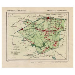
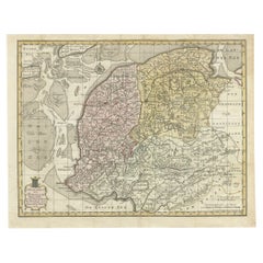
Antique Print of the Province of Friesland, The Netherlands, 1868
About the Item
Antique map titled 'Provincie Friesland'.
Map of Friesland, the Netherlands. This map originates from 'Gemeente-Atlas van Nederland' by J. Kuyper.
Artists and Engravers: Published by H. Suringar.
Condition: Good, general age-related toning. Minor wear, blank verso. Please study image carefully.
- Dimensions:Height: 10.44 in (26.5 cm)Width: 7.88 in (20 cm)Depth: 0 in (0.02 mm)
- Materials and Techniques:
- Period:
- Date of Manufacture:1868
- Condition:
- Seller Location:Langweer, NL
- Reference Number:
About the Seller
5.0
Platinum Seller
These expertly vetted sellers are 1stDibs' most experienced sellers and are rated highest by our customers.
Established in 2009
1stDibs seller since 2017
1,933 sales on 1stDibs
Typical response time: <1 hour
- ShippingRetrieving quote...Ships From: Langweer, Netherlands
- Return PolicyA return for this item may be initiated within 14 days of delivery.
More From This SellerView All
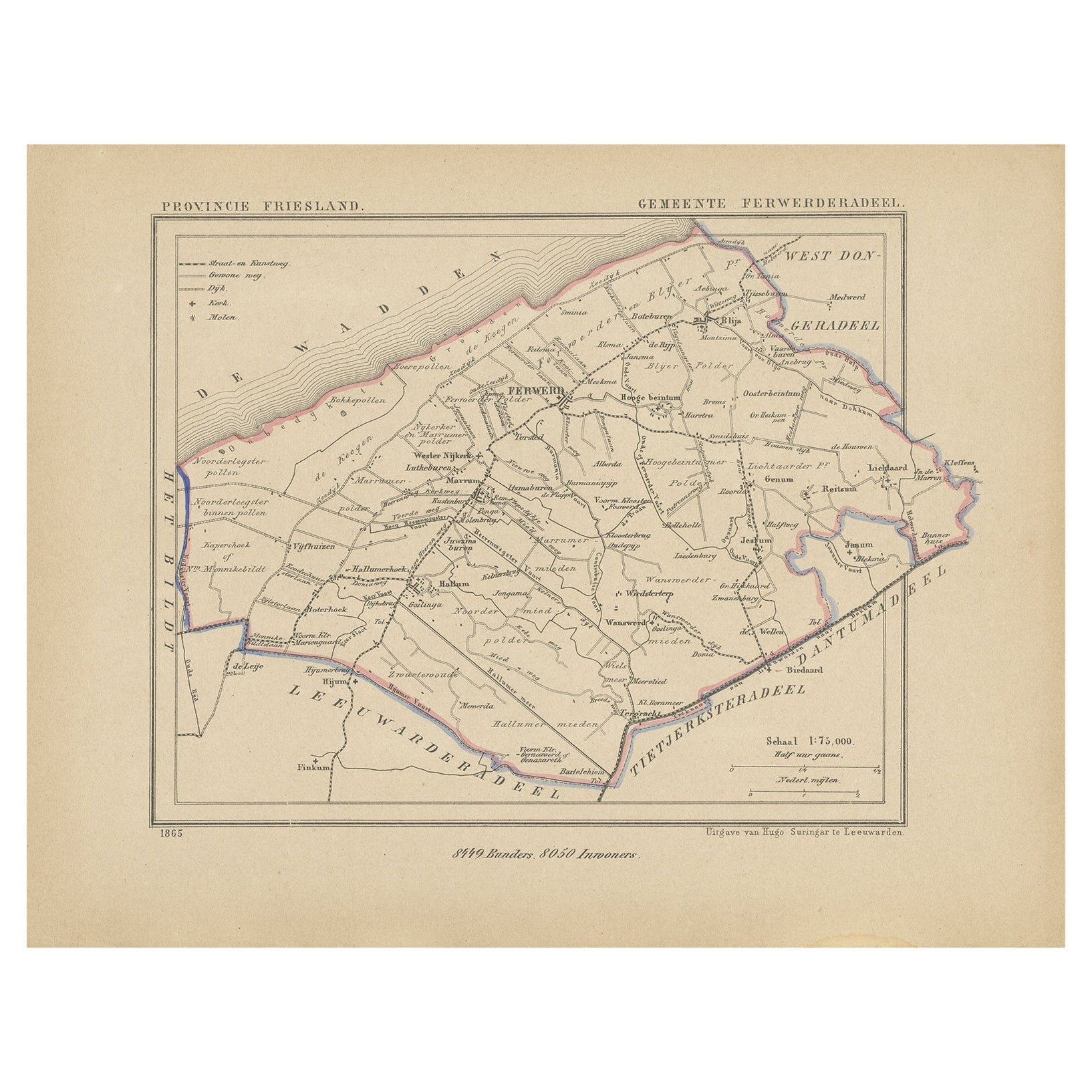
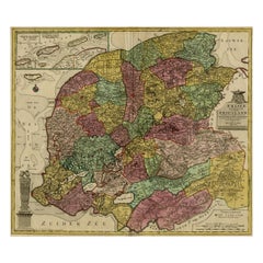
- Antique Map of Ferwerderadeel, Friesland, the Netherlands, 1868Located in Langweer, NLAntique map titled 'Provincie Friesland - Gemeente Ferwerderadeel'. Map of the township of Ferwerderadeel including Ferwerd, Blija and many other villages. This map originates from '...Category
Antique 19th Century Maps
MaterialsPaper
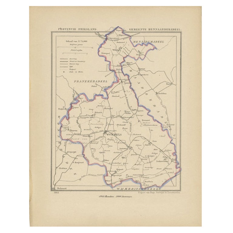
- Antique Map of Hennaarderadeel, Friesland, the Netherlands, 1868Located in Langweer, NLAntique map titled 'Provincie Friesland - Gemeente Hennaarderadeel'. Map of the township of Hennarderadeel including Oosterend, Wommels and many other villages. This map originates f...Category
Antique 19th Century Maps
MaterialsPaper
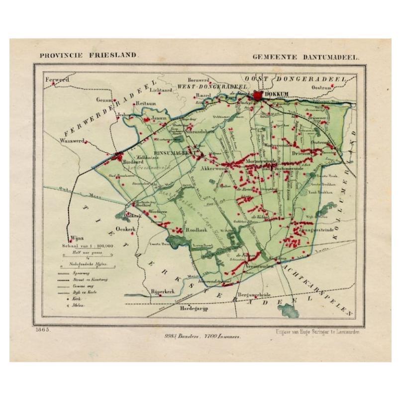
- Antique Map of Dantumadeel, Friesland, The Netherlands, 1868Located in Langweer, NLAntique map titled 'Provincie Friesland - Gemeente Dantumadeel'. Map of the township of Dantumadeel including Birdaard, Rinsumageest, Veenwouden and many other villages. This map ori...Category
Antique 19th Century Maps
MaterialsPaper
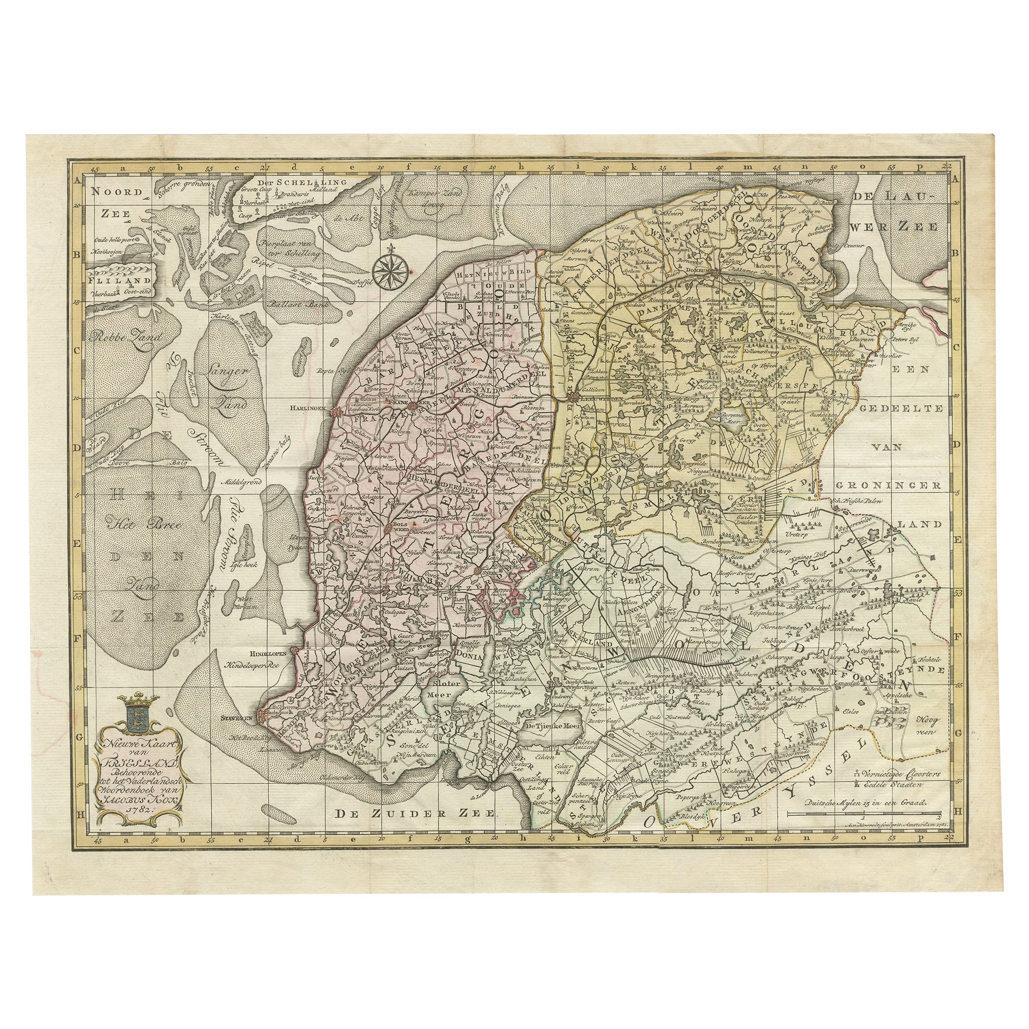
- Antique Map of Province Friesland, The Netherlands, 1787Located in Langweer, NLAntique map titled 'Nieuwe Kaart van Friesland behoorende tot het Vaderlandsch Woordenboek van Jacobus Kok'. Original antique map of the province of Friesland, the Netherlands. This ...Category
Antique 18th Century Maps
MaterialsPaper
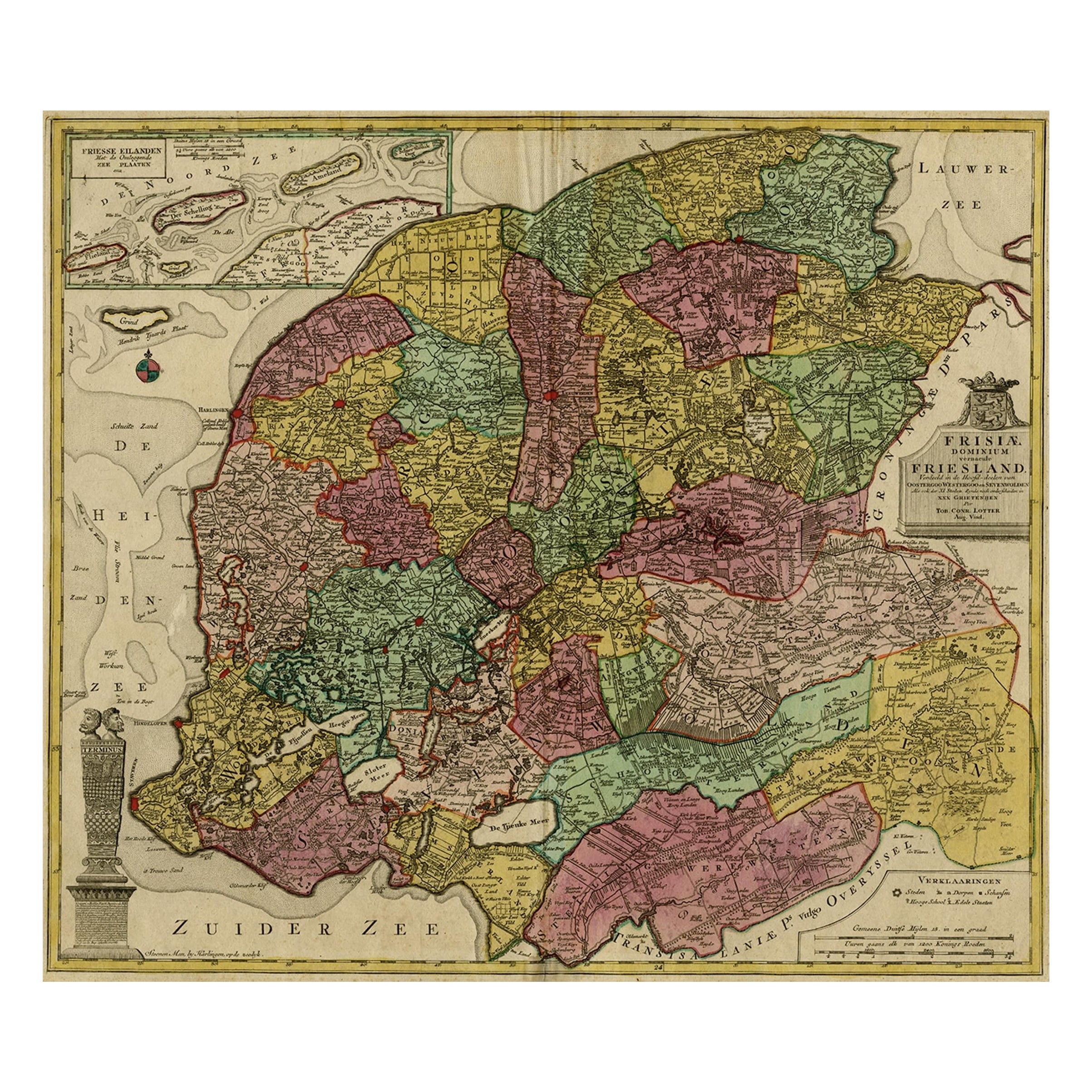
- Antique Map of the Province of Friesland, The Netherlands, c.1760Located in Langweer, NLAntique map titled 'Frisiae Dominium vernacule Friesland, verdeeld in de Hoofd-deelen van Oostergoo, Westergoo en Sevenwolden, Als ook der XI Steden Zynde noch onderscheiden in XXX G...Category
Antique 18th Century Maps
MaterialsPaper
- Antique Map of Leeuwarderadeel in Friesland, The Netherlands, 1868Located in Langweer, NLAntique map titled 'Provincie Friesland - Gemeente Leeuwarderadeel'. Map of the township of Leeuwarderadeel including Friesland's Capital Leeuwarden and furthermore: Wirdum, Wytg...Category
Antique 19th Century Maps
MaterialsPaper

You May Also Like
- Antique 18th Century Map of the Province of Pensilvania 'Pennsylvania State'Located in Philadelphia, PAA fine antique of the colony of Pennsylvania. Noted at the top of the sheet as a 'Map of the province of Pensilvania'. This undated and anonymous map is thought to be from the Gentleman's Magazine, London, circa 1775, although the general appearance could date it to the 1760's. The southern boundary reflects the Mason-Dixon survey (1768), the western boundary is placed just west of Pittsburgh, and the northern boundary is not marked. The map has a number of reference points that likely refer to companion text and appear to be connected to boundaries. The western and southern boundaries are marked Q, R, S, for example. A diagonal line runs from the Susquehanna R to the Lake Erie P. A broken line marked by many letters A, B, N, O, etc., appears in the east. There are no latitude or longitude markings, blank verso. Framed in a shaped contemporary gilt wooden frame and matted under a cream colored matte. Bearing an old Graham Arader Gallery...Category
Antique 18th Century British American Colonial Maps
MaterialsPaper
- Original Antique Map of The Netherlands, Sherwood, Neely & Jones, Dated 1809Located in St Annes, LancashireGreat map of The Netherlands Copper-plate engraving by Cooper Published by Sherwood, Neely & Jones. Dated 1809 Unframed.Category
Antique Early 1800s English Maps
MaterialsPaper
- Original Antique Map of The Netherlands, Engraved by Barlow, Dated 1807Located in St Annes, LancashireGreat map of Netherlands Copper-plate engraving by Barlow Published by Brightly & Kinnersly, Bungay, Suffolk. Dated 1807 Unframed.Category
Antique Early 1800s English Maps
MaterialsPaper
- 1868 Map of the Upper Part of the Island of Manhattan Above 86th StreetBy Wm. Rogers Mfg. Co.Located in San Francisco, CAThis wonderful piece of New York City history is over 150 years old. It depicts 86th street and above. It was lithographed by WC Rogers and company. It was made to show what was the Battle of Harlem during the Revolutionary war...Category
Antique 1860s American American Colonial Maps
MaterialsPaper
- Wilhelmina, Queen of the Netherlands, 1898 Inauguration Commemorative PlatesBy Petrus RegoutLocated in Sharon, CTOffering four hand-painted Wilhelmina, “1890-1948” Inauguration plates, manufactured in 1898 by Petrus Regout & Co., Maastricht, Holland.Category
Antique 1890s Dutch Art Nouveau Historical Memorabilia
MaterialsCeramic
- William Theed the Younger 1804-91 Marble Bust of William Ewart Gladstone 1868Located in Lowestoft, GBA very finely carved marble bust of William Ewart Gladstone dated 1868 and signed W.Theed SC William Theed was born in Staffordshire, his father, William Theed the elder being a sculptor and a craftsman at Wedgwood, known for his major work, Hercules and the Thracian Horses for one frontage of the Buckingham Palace complex. The younger Theed studied at the Royal Academy Schools, then worked for the sculptor E. H. Baily. Five years on, in 1826, he went to Rome, where he was to stay a total of 22 years, during that time working in the studios of Thorwaldson and John Gibson. Returning to London in 1848, Theed enjoyed a good reputation, being a favoured sculptor of Queen Victoria, and was commissioned to produce many portrait statues, busts, and large monuments. He showed work in the 1851 Great Exhibition, and among other high points were a group for the Albert Memorial, and five standing figures on the Inland Revenue side of Somerset House, representing Manchester, Edinburgh, Glasgow, Belfast and Dublin. Theed's statues may be seen in St Paul's (Henry Hallam), Manchester (Monument to Chetham in the Cathedral, Gladstone and Thomas Bright for the Town Hall, and James Watt in Piccadilly Gardens), Huddersfield (Robert Peel), Winchester (David Williams monument in the Cathedral), and Prince Albert statues for Grimsby, and in Australia in Macquairie Street, Sydney. He was also responsible for three of the portrait statues (Bacon, Locke, Adam Smith...Category
Antique 1860s English Victorian Busts
MaterialsMarble


Recently Viewed
View AllMore Ways To Browse
The Netherlands
Furniture From The Netherlands
Antique The Netherlands
Antique Furniture From Netherlands
J Blank
Antique Province Map
Map Of Antique Province
Antique Province Map Of Antique
Antique Map Of The United States
Antique Maps Of The United States
Antique African American
African American Antique
Antique Furniture East London
Antique Eastern European Furniture
Vintage Map Of The United States
Antique House Plans
Antique Metal Window
Antique Metal Windows