Items Similar to School Chart or Pull Down Map of Geography of the Netherlands, 1950s


Want more images or videos?
Request additional images or videos from the seller
1 of 10
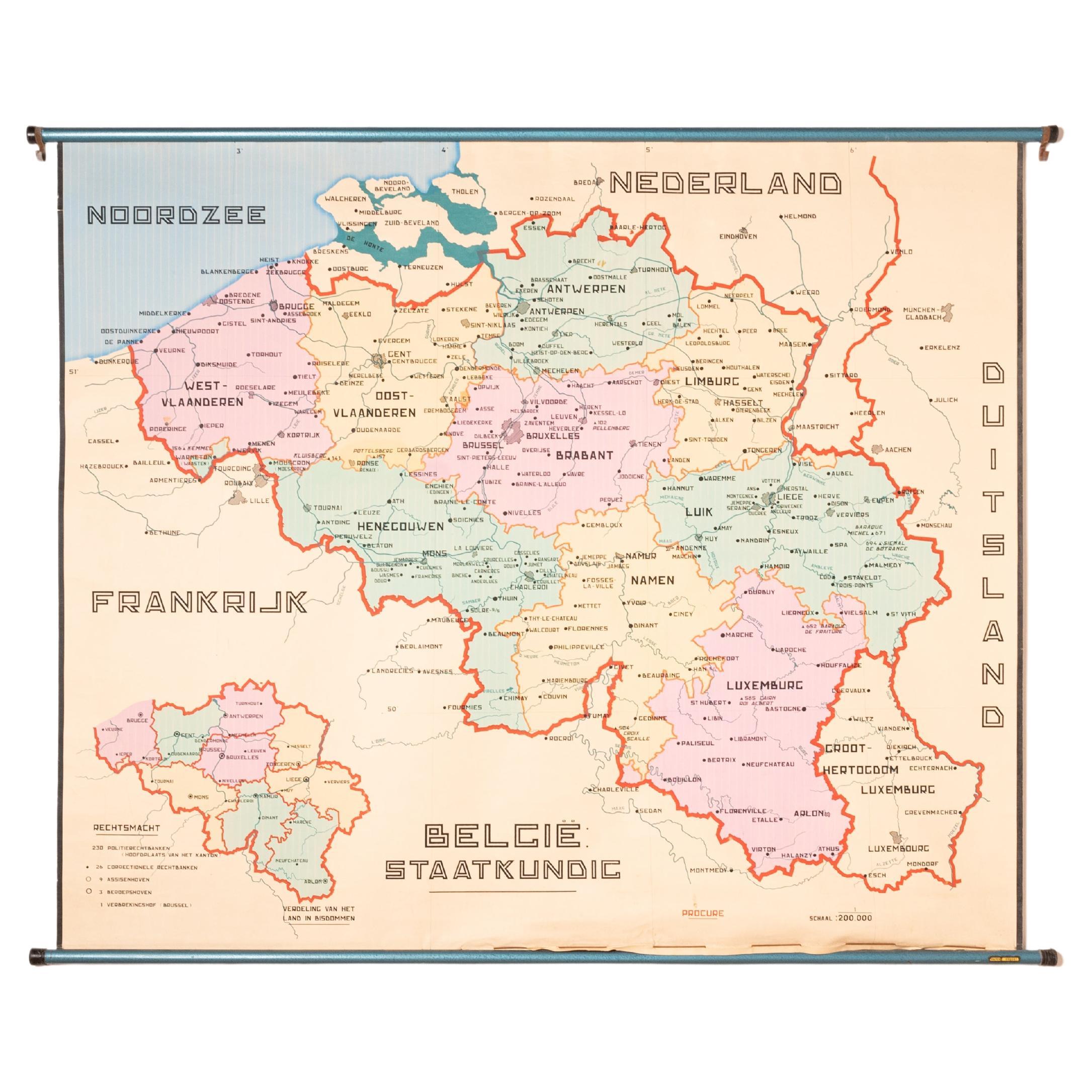
School Chart or Pull Down Map of Geography of the Netherlands, 1950s
About the Item
A beautiful old school map of the Netherlands, painted on linen. The map shows the 3 different reliefs (low, middle, high) of the Netherlands. The beautiful colors give this school map a colorful touch to your interior. The text is in Dutch. There are some small tears at the edges, but the linen is otherwise undamaged. The school map is in very nice condition.
Belgium, probably 1950s
Designer/manufacturer: Unknown for De Procure (Brussels)
In good vintage condition, with normal signs of use.
Dimensions: 99 (H) x 115 (W) cm.
- Dimensions:Height: 38.98 in (99 cm)Width: 45.28 in (115 cm)Depth: 1.97 in (5 cm)
- Style:Mid-Century Modern (Of the Period)
- Materials and Techniques:
- Place of Origin:
- Period:
- Date of Manufacture:1950
- Condition:Wear consistent with age and use. In good vintage condition, with normal signs of use.
- Seller Location:Hemiksem, BE
- Reference Number:
About the Seller
No Reviews Yet
Vetted Seller
These experienced sellers undergo a comprehensive evaluation by our team of in-house experts.
1stDibs seller since 2022
5 sales on 1stDibs
Typical response time: 5 hours
- ShippingRetrieving quote...Ships From: Hemiksem, Belgium
- Return PolicyA return for this item may be initiated within 14 days of delivery.
More From This SellerView All
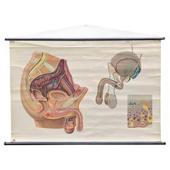
- Vintage Wall Chart or Pull-Down Map of Male Anatomy, 1950sLocated in Hemiksem, VANAn original vintage pull-down chart of the male anatomy. This poster shows the different parts of the male reproductive system. The chart has a splendid ...Category
Vintage 1950s German Mid-Century Modern Posters
MaterialsWood, Paper
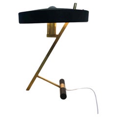
- Z-Lamp or Diplomat by Louis Kalff for Philips, Netherlands, 1950sBy Louis KalffLocated in Hemiksem, VANOriginal 1950s Z or Diplomat lamp by Louis Kalff for Philips. This well-known desk lamp has a solid brass frame in the shape of a Z. The lampshade is m...Category
Vintage 1950s Dutch Mid-Century Modern Table Lamps
MaterialsMetal, Brass
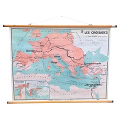
- Vintage Wall Chart 'Crusades of the Early Middle Ages'Located in Hemiksem, VANA beautiful, original vintage map of the crusades ('Les Croisades') in the early Middle Ages in Europe, North Africa, and the Middle East. This pull-down ...Category
Vintage 1960s French Mid-Century Modern Posters
MaterialsWood, Paper
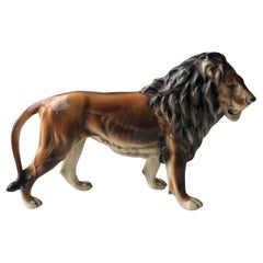
- Lion Sculpture or Statue or Figurine in Ceramic or Porcelain, 1950sLocated in Hemiksem, VANBeautiful vintage statue of a lion in porcelain. This figurine shows no damage and has a stamp at the bottom of the leg. Unknown, 1950s Designer/Manufacturer: See stamp In very go...Category
Vintage 1950s Italian Hollywood Regency Animal Sculptures
MaterialsCeramic
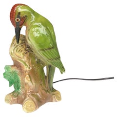
- Bird Fragrance Lamp or Perfume Lamp, Germany, 1950sLocated in Hemiksem, VANCute lamp in porcelain of a woodpecker. These lamps were produced in the past in the shape of all kinds of animals and used as a fragrance or perfume lamp to...Category
Vintage 1950s German Mid-Century Modern Table Lamps
MaterialsPorcelain
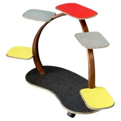
- Mid-Century Colorful Plant Stand or Flower Table, Germany, 1950sLocated in Hemiksem, VANMid-century plant stand from the 1960s. This colorful little table is made of wood and Formica in yellow, gray, red, and dark gray with a pattern. The shelves have the typical gold-c...Category
Vintage 1950s German Mid-Century Modern Side Tables
MaterialsBrass
You May Also Like
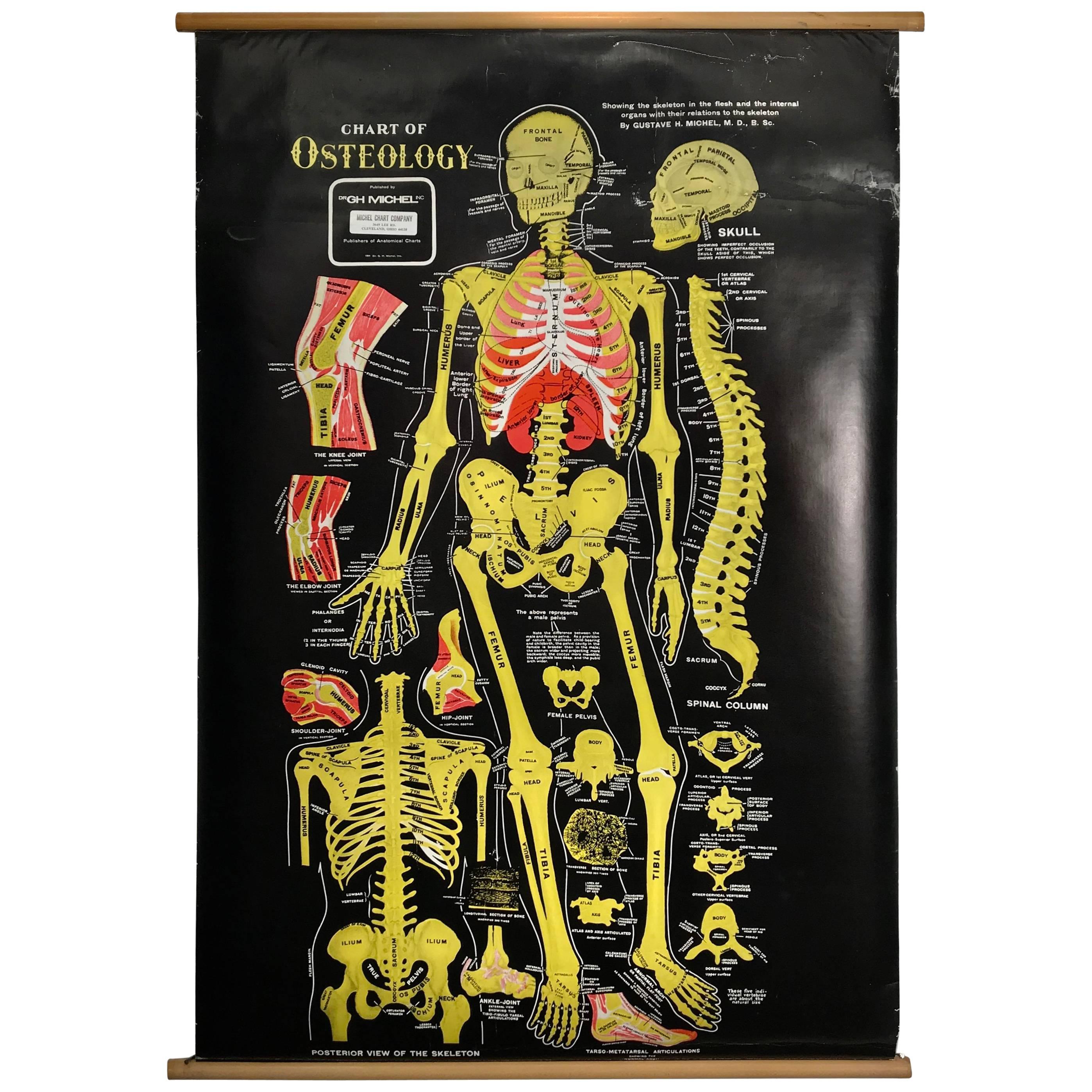
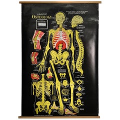
- Vintage Anatomical Pull Down Chart 'Osteology, GH Michel CompanyBy G.H. Michel CompanyLocated in Buffalo, NYVintage Anatomical Pull Down Chart 'OSTEOLOGY ,GH Michel Company,Black background,amazing color contrast.Beautifully screened printed,linen backed.S...Category
Vintage 1960s American Mid-Century Modern Posters
MaterialsLinen, Paper
- XL Old School Map of Belgium 'Printed by Procure', 1950sLocated in Oostende, BEXL Old school map of Belgium (Printed by Procure). Presumably from around 1950-1960.Category
Vintage 1950s Belgian Mid-Century Modern Maps
MaterialsMetal
- Geographical Antique Map of Principality of MonacoBy Bruno SantiniLocated in Alessandria, PiemonteST/609 - Interesting antique color map of Monaco Principality in French language : "Carte qui contient le Principauté de Piémont, le Monferrat et la comté de...Category
Antique Late 18th Century Italian Other Maps
MaterialsPaper
- Antique Map of the Province of Overijssel, the NetherlandsLocated in Langweer, NLOriginal antique map titled 'Ditio Trans-Isulana'. Original old map of the province of Overijssel, the Netherlands. With coat of arms and two decorative cartouches. Published by J. J...Category
Antique Mid-17th Century Maps
MaterialsPaper
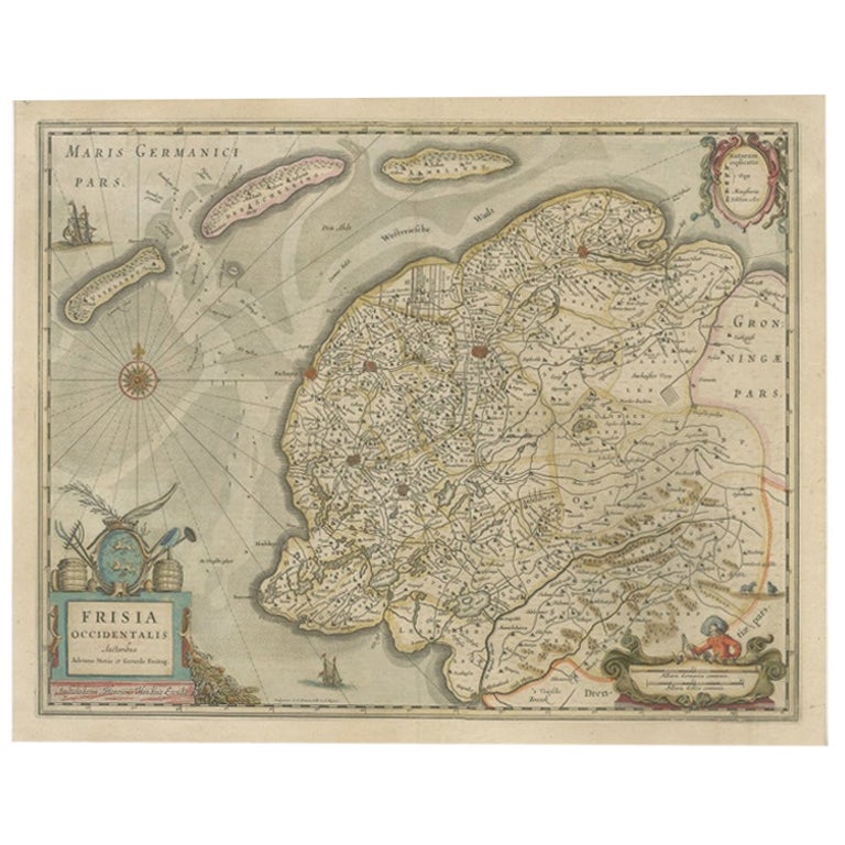
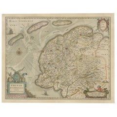
- Antique Map of Friesland, The Netherlands, 1638Located in Langweer, NLAntique map titled 'Frisia Occidentalis'. Original antique map of Friesland, the Netherlands. First state, originating from 'Atlantis novi pars secunda' published 1638. Artis...Category
Antique 17th Century Maps
MaterialsPaper
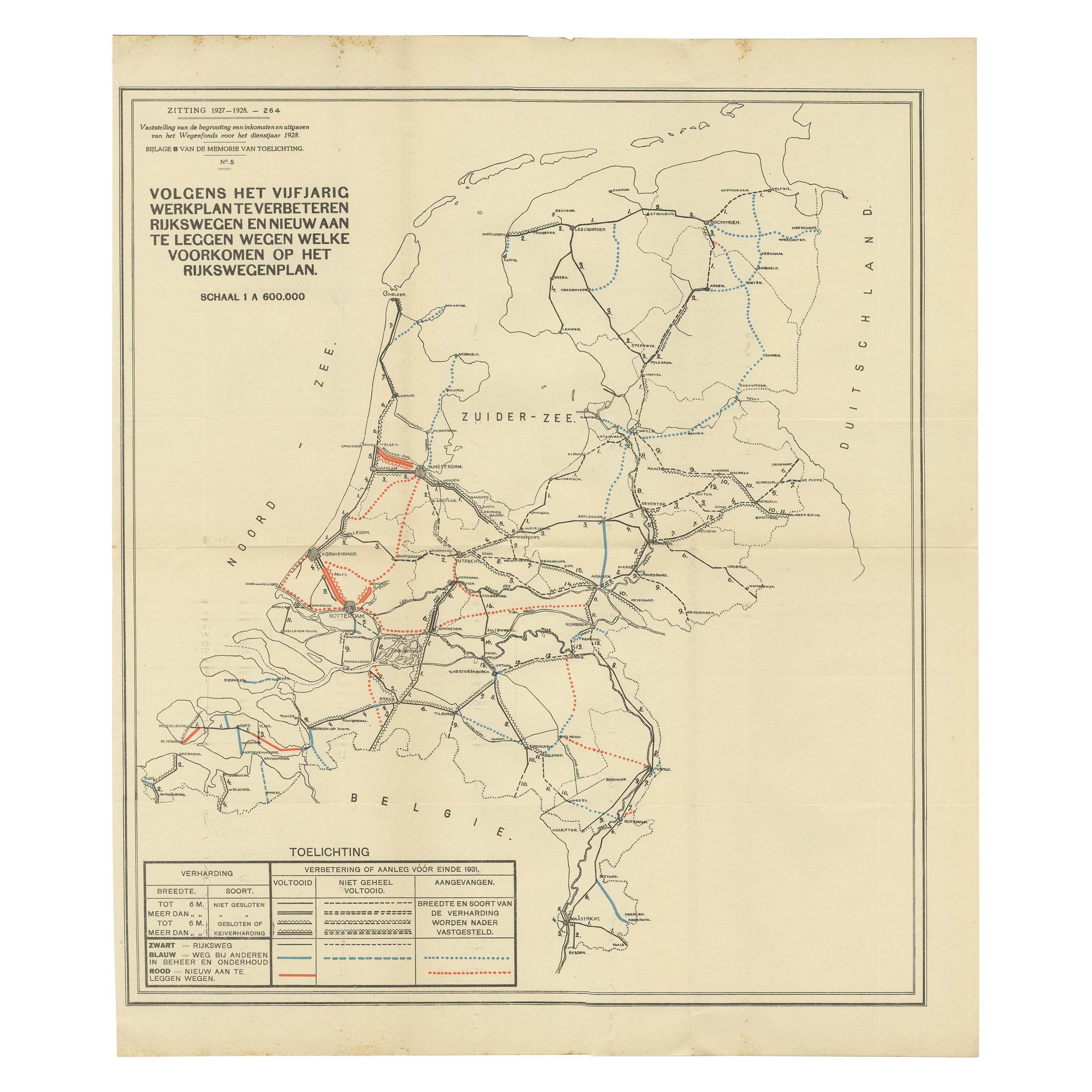
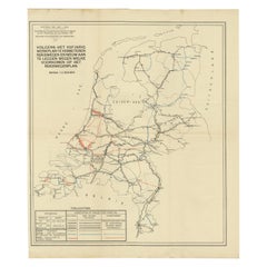
- Vintage Road Map of the Netherlands '1928'Located in Langweer, NLVintage map titled 'Volgens het vijfjarig Werkplan te verbeteren Rijkswegen en nieuw aan te leggen wegen welke voorkomen op het Rijkswegenplan'. Map of the Netherlands...Category
20th Century Maps
MaterialsPaper


Recently Viewed
View AllMore Ways To Browse
Map Of Gulf Of Mexico
Antique Map Of Sri Lanka
Pirate Map
Chinese Plague
St Thomas Cross
Map Of Liverpool
Georgetown Antique
Antique Map Mexico City
Tartar Map
Authentic Pirate
Antique Maps Of Kansas
Nova Scotia Map
Map Of Kentucky
Antique Map Delaware
Map Of Utah
Royal Picardie
Vintage Maps Of Hawaii
Vintage Road Maps Collectables