Items Similar to Map of Kingdoms of Castile, León, Galicia, Asturias, Biscay and Navarre in Spain
Want more images or videos?
Request additional images or videos from the seller
1 of 10
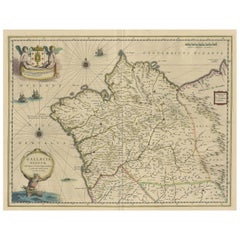
Map of Kingdoms of Castile, León, Galicia, Asturias, Biscay and Navarre in Spain
$632.62
$790.7720% Off
£470.94
£588.6820% Off
€528
€66020% Off
CA$866.53
CA$1,083.1620% Off
A$963.77
A$1,204.7120% Off
CHF 503.25
CHF 629.0620% Off
MX$11,728.08
MX$14,660.0920% Off
NOK 6,427.29
NOK 8,034.1120% Off
SEK 6,027.66
SEK 7,534.5820% Off
DKK 4,019.48
DKK 5,024.3520% Off
Shipping
Retrieving quote...The 1stDibs Promise:
Authenticity Guarantee,
Money-Back Guarantee,
24-Hour Cancellation
About the Item
Antique map titled 'Partie Septentrionale de la Couronne de Castille (..)'. Decorative and highly detailed map of Northwestern Spain, including Gallicia, Leon, Asturias, Old Castille, New Castille and Biscaya. Extends to Madrid and Toledo. Published by Vaugondy, circa 1752.
Description:
This historical map, titled "Partie Septentrionale de la Couronne de Castille*, was created in 1752 by the renowned French cartographer Robert de Vaugondy. The map illustrates the northern part of Spain, encompassing the regions known historically as the Kingdoms of Old Castile, León, Galicia, Asturias, Biscay, and Navarre. These areas were significant during the time as they formed the northern territories of the Spanish Crown, known as the "Crown of Castile."
Notable Features:
- Cartographer: Robert de Vaugondy, a distinguished French geographer, known for his detailed and accurate maps, was the official cartographer to the King of France. His works are highly regarded for their precision and artistry.
- Important Places:
- Madrid (shown towards the southern part of the map, emphasizing its importance as the capital of Spain).
- Santiago de Compostela (a historic city in Galicia, famous for the cathedral that is the destination of the Camino de Santiago pilgrimage).
- Burgos and Valladolid (key cities in Old Castile, important for their historical and cultural significance).
- Oviedo (the capital of Asturias, known for its medieval old town).
- Pamplona (capital of Navarre, famous for the Running of the Bulls).
- Santander (an important port city in the region of Cantabria).
- Bilbao and San Sebastián (significant cities in Biscay, known for their economic and cultural importance).
Map Details:
- Scale: The map includes a scale bar, which allows the user to measure distances accurately.
- Borders: The map outlines the borders of each kingdom with different colors, helping to distinguish between the various regions.
- Geographical Features: Detailed depiction of the mountainous terrain, rivers, and coastal lines along the Bay of Biscay.
This map is not only a valuable resource for historical study but also a beautiful piece of cartographic art, reflecting the geographical knowledge and political boundaries of mid-18th century Spain.
Gilles Robert de Vaugondy (1688-1766) and Didier Robert de Vaugondy (1723-1786) were influential figures in the realm of 18th-century French cartography. Originating from Paris, their contributions to mapmaking were significant during an era of expansive geographical exploration.
- Dimensions:Height: 20.48 in (52 cm)Width: 27.88 in (70.8 cm)Depth: 0.02 in (0.5 mm)
- Materials and Techniques:
- Period:
- Date of Manufacture:c.1752
- Condition:General age-related toning. Original folding line. Shows some wear, blank verso. Please study image carefully.
- Seller Location:Langweer, NL
- Reference Number:Seller: BG-13430-11stDibs: LU3054339031912
About the Seller
5.0
Recognized Seller
These prestigious sellers are industry leaders and represent the highest echelon for item quality and design.
Platinum Seller
Premium sellers with a 4.7+ rating and 24-hour response times
Established in 2009
1stDibs seller since 2017
2,510 sales on 1stDibs
Typical response time: <1 hour
- ShippingRetrieving quote...Shipping from: Langweer, Netherlands
- Return Policy
Authenticity Guarantee
In the unlikely event there’s an issue with an item’s authenticity, contact us within 1 year for a full refund. DetailsMoney-Back Guarantee
If your item is not as described, is damaged in transit, or does not arrive, contact us within 7 days for a full refund. Details24-Hour Cancellation
You have a 24-hour grace period in which to reconsider your purchase, with no questions asked.Vetted Professional Sellers
Our world-class sellers must adhere to strict standards for service and quality, maintaining the integrity of our listings.Price-Match Guarantee
If you find that a seller listed the same item for a lower price elsewhere, we’ll match it.Trusted Global Delivery
Our best-in-class carrier network provides specialized shipping options worldwide, including custom delivery.More From This Seller
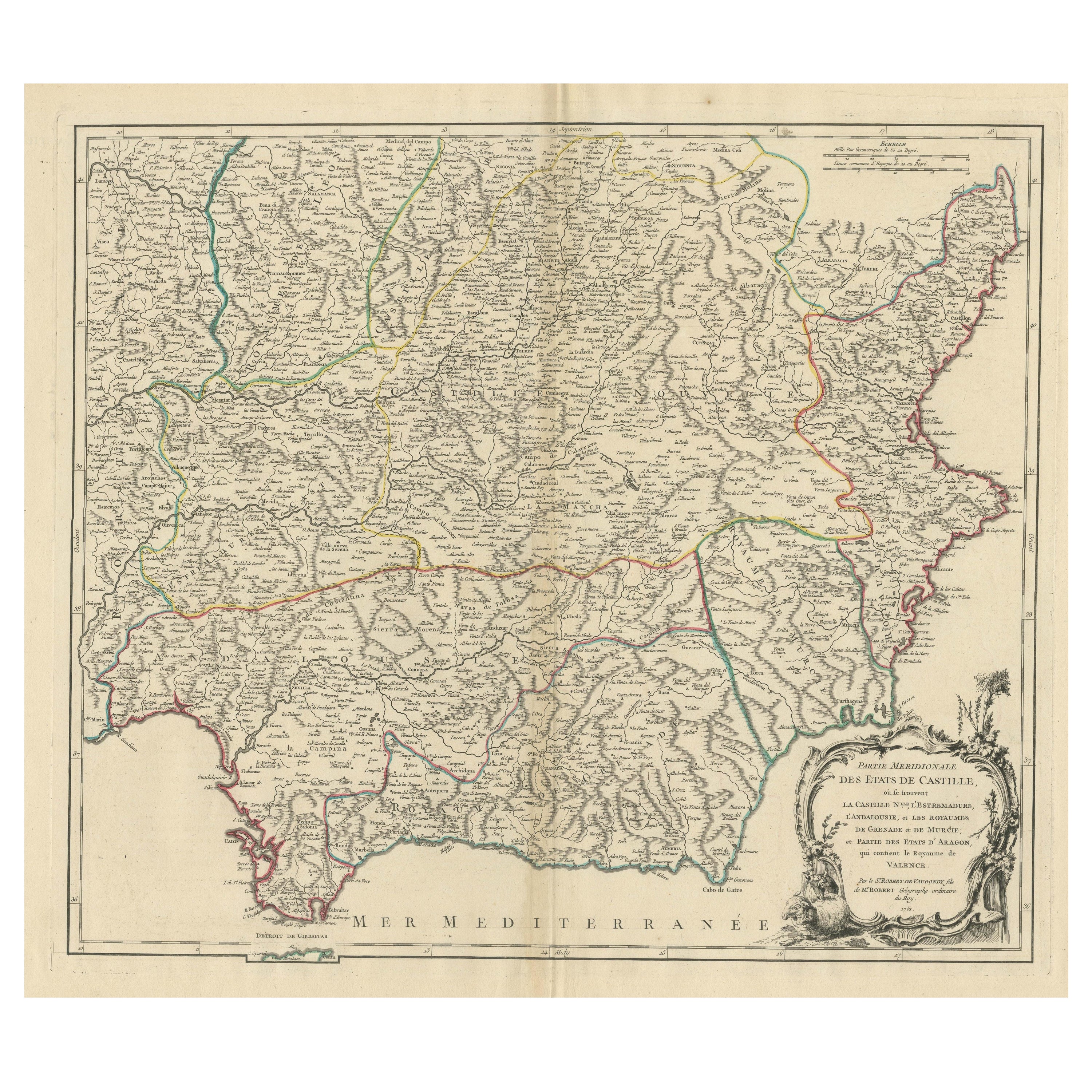
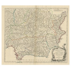
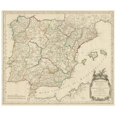
View AllMap of Southern Spain Depicting Castile, Andalusia, Granada, Murcia and Valencia
Located in Langweer, NL
Antique map titled 'Partie Meridionale Des Etats de Castille (..)'. Decorative and highly detailed map of the southern part of Castile, Spain, including a decorative cartouche. Publi...
Category
Antique Mid-18th Century Maps
Materials
Paper
$632 Sale Price
20% Off
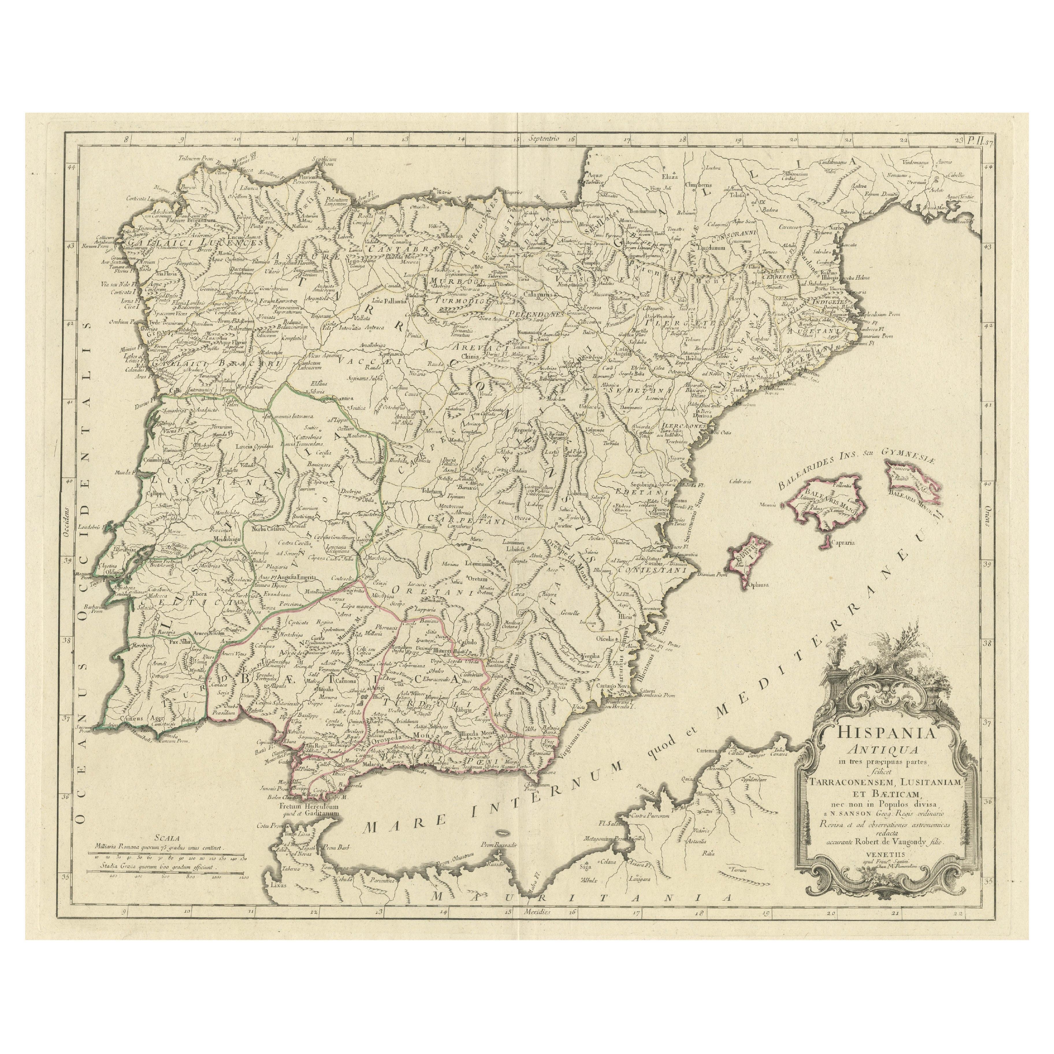
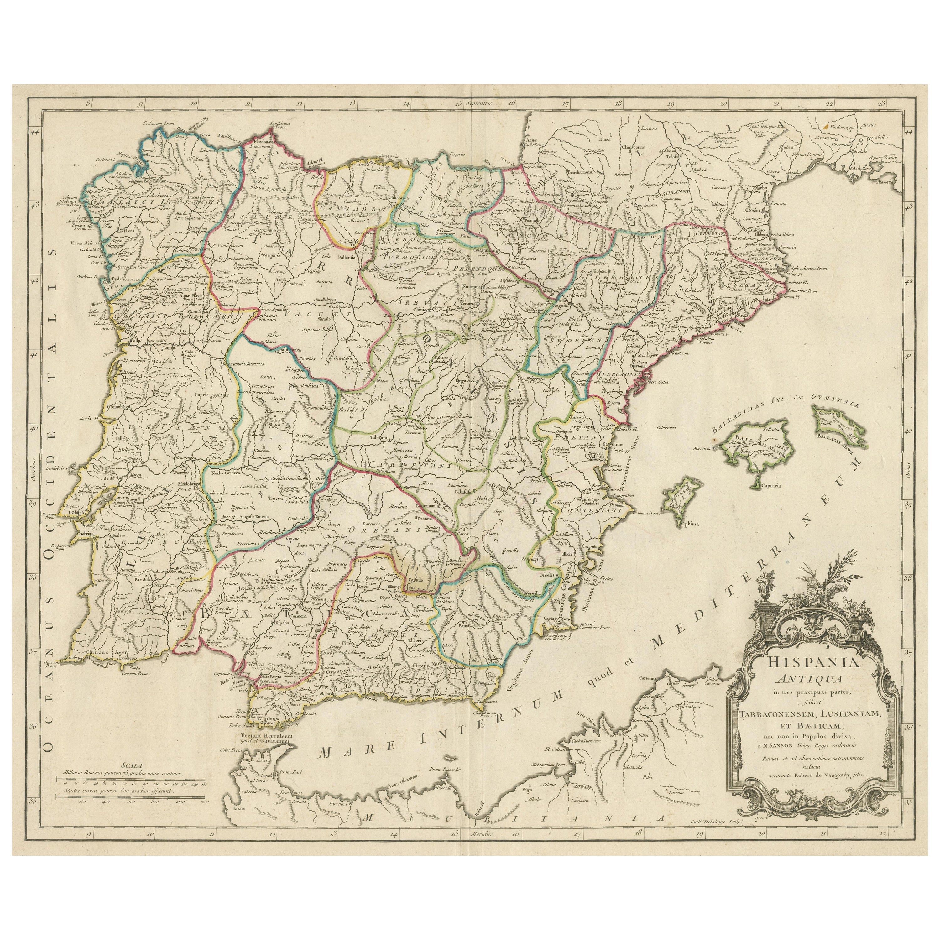
Old Map of Ancient Spain and Portugal – Hispania Antiqua Featuring Roman Cities
Located in Langweer, NL
Title: "Hispania Antiqua in Tres Praecipuas Partes Divisa: Tarraconensem, Lusitaniam, et Bæticam" by Robert de Vaugondy, 18th Century
Description:
This beautifully detailed map titl...
Category
Antique Late 18th Century Maps
Materials
Paper
$632 Sale Price
20% Off
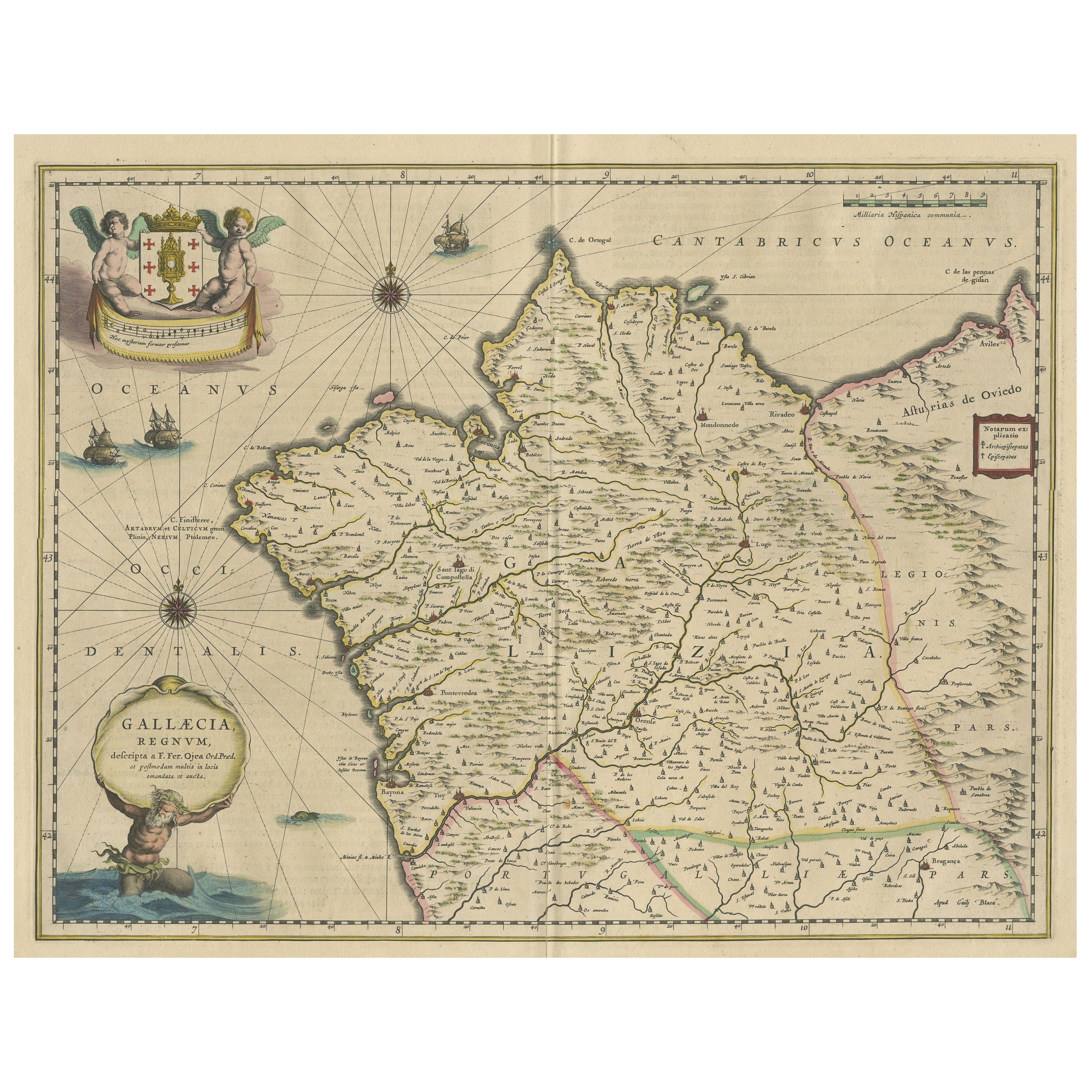
Antique Map of the Northwestern Coast of Spain
Located in Langweer, NL
Antique map titled 'Gallaecia Regnum'. Original old map of the northwestern coast of Spain, extending from the Asturias de Oviedo region and Aviles in the Northeast to Bayona and the...
Category
Antique Mid-17th Century Maps
Materials
Paper
$555 Sale Price
20% Off
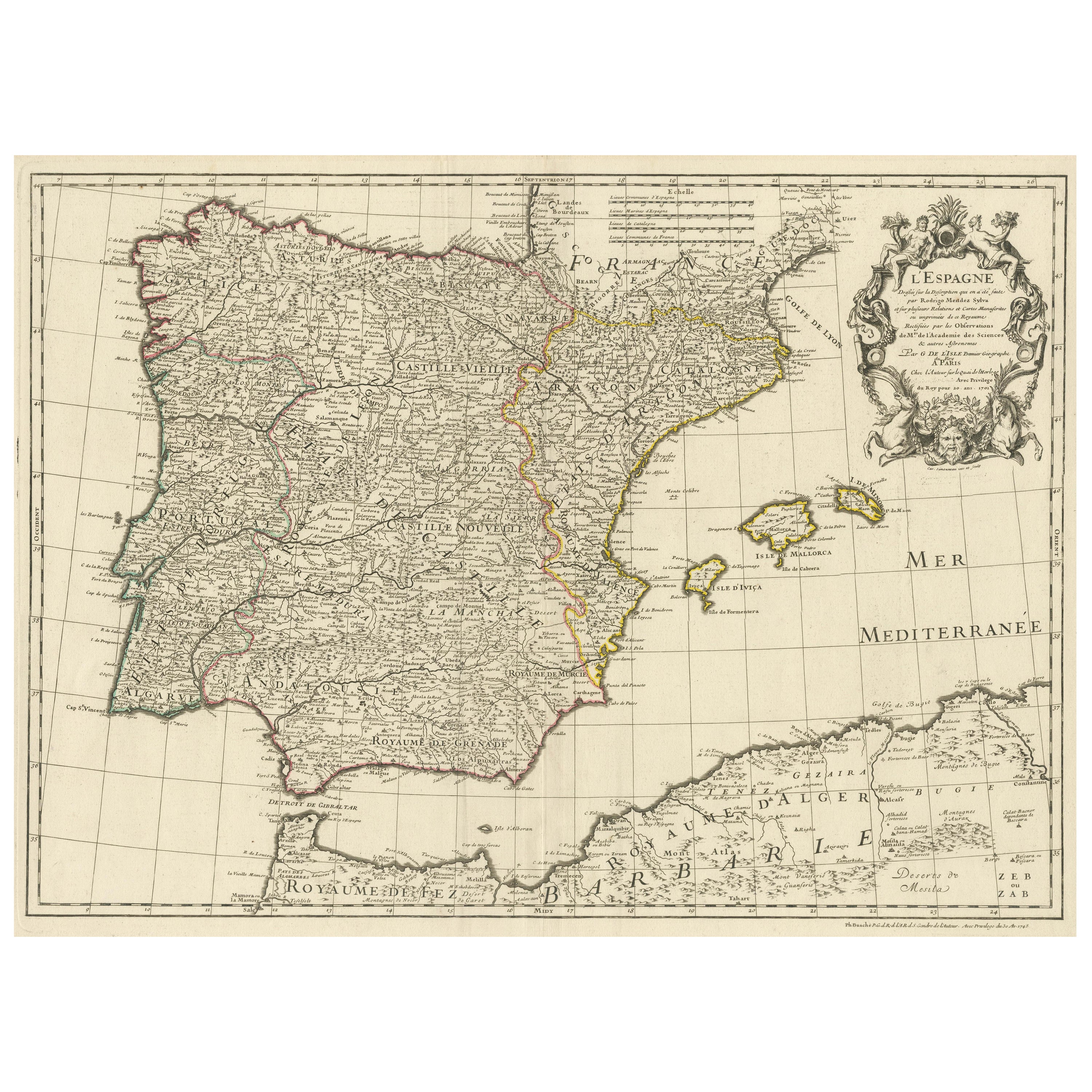
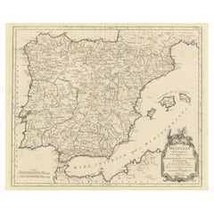
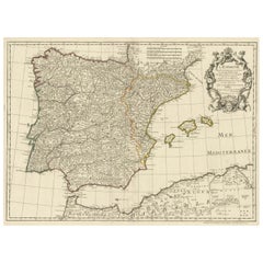
Large Decorative Map of the Iberian Peninsula
Located in Langweer, NL
Antique map titled 'L'Espagne (..)'. Large map of the Iberian Peninsula, including the Balearic Islands and part of the north coast of Africa. The map is based on the cartography of ...
Category
Antique Mid-18th Century Maps
Materials
Paper
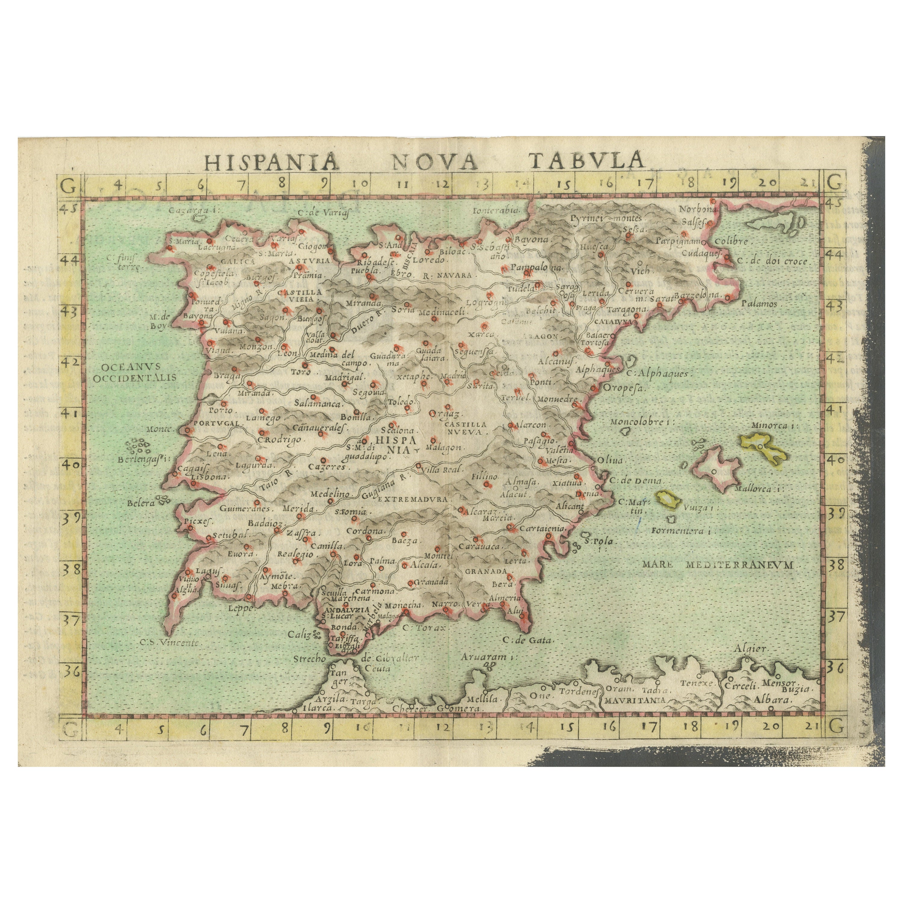
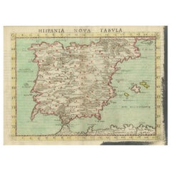
Antique Map of Spain including the Balearic Islands
Located in Langweer, NL
Antique map titled 'Hispania Nova Tabula'. Ruscelli's map of Spain, including the Balearic Islands. This map originates from 'Espositione & introduttioni universali di Gir. Ruscelli sopra tutta la Geografia di Tolomeo (..)' published by Girolamo Ruscelli, 1561.
Girolamo Ruscelli (1500-1566) was a cartographer, humanist, and scholar from Tuscany. Ruscelli was a prominent writer and editor in his time, writing about a wide variety of topics including the works of Giovanni Boccaccio and Francesco Petrarch, Italian language, Italian poetry, medicine, alchemy, and militia. One of his most notable works was a translation of Ptolemy’s Geographia...
Category
Antique 16th Century Maps
Materials
Paper
Large Antique Map of Ancient Spain and Portugal, Published in circa 1760
Located in Langweer, NL
Antique map titled 'Hispania Antiqua (..)'. Map of ancient Spain and Portugal. Engraved by G. Delahaye. Published circa 1760, by or after Sanson & Vaugondy.
Category
Antique Mid-18th Century Maps
Materials
Paper
$421 Sale Price
20% Off
You May Also Like
1751 Map of Spain Castilla Robert De Vaugondy 1st Edition, Ric.a001
Located in Norton, MA
Large Spain Castilla Robert De Vaugondy
1751 1st Edition
-Colored- Ric.a001
Coming from a family of cartographers, a descendant of the famous Nicolas Sanson and ordinary geographer of the king, Gilles Robert de Vaugondy makes himself known by his maps of the French provinces.
He published an Essay on the History of Geography (1755) from which he excluded the physical geography "too systematic". After a Small Atlas (1748), he draws a universal Atlas (1758), a portable Atlas (1762).
His Atlas of the revolutions of the globe remains unpublished. His warnings and prefaces, his book reviews reveal a Cartesian mind and solid knowledge.
Very early, he associates with his works his son Didier who publishes, since 1742, the methodical tables of Nicolas Sanson, two Globes, one terrestrial, the other celestial (1752).
He is credited with a map of Poland...
Category
Antique 18th Century Unknown Maps
Materials
Paper

Original Antique Map of Spain and Portugal, circa 1790
Located in St Annes, Lancashire
Super map of Spain and Portugal
Copper plate engraving by A. Bell
Published, circa 1790.
Unframed.
Category
Antique 1790s English Other Maps
Materials
Paper

Geographical Antique Map of Principality of Monaco
By Bruno Santini
Located in Alessandria, Piemonte
ST/609 - Interesting antique color map of Monaco Principality in French language : "Carte qui contient le Principauté de Piémont, le Monferrat et la comté de...
Category
Antique Late 18th Century Italian Other Maps
Materials
Paper

Portugal: A Large 17th Century Hand-colored Map by Sanson and Jaillot
By Nicolas Sanson
Located in Alamo, CA
This large hand-colored map entitled "Le Royaume de Portugal et des Algarves Divisee en see Archeveches, Eveches et Territoires Par le Sr Sanson" was originally created by Nicholas S...
Category
Antique 1690s French Maps
Materials
Paper

Map of the Kingdom of Sardinia and Part of the Kingdom of Genoa, Rome
By Giovanni Maria Cassini
Located in Hamilton, Ontario
18th century map by Italian engraver Giovanni Maria Cassini (Italy 1745-1824). Map of Part of the Kingdom of Sardinia and Part of the Kingdom of Genoa: Rome. This is a hand colored a...
Category
Antique 18th Century Italian Maps
Materials
Paper

$795 Sale Price
36% Off
17th Century Lithograph Framed Map of Spain
Located in Atlanta, GA
In giltwood frame, dated 1652.
Category
Antique 18th Century and Earlier Spanish Baroque Prints
Materials
Ink, Paper

More Ways To Browse
Cathedral Crown
Antique Toledo Scale Scales
Antique Toledo Scale
Used Furniture Oviedo
20th Century Spanish Table
Antonio Bellini
Antique Oushak Carpets
Blue Coffee Tables
German Bauhaus Posters
1945 Chair Juhl
Antique Three Leg Table
Folke Arstrom
Silver Over Copper
Vintage Barware Glasses
Antique Etched Glass
Antique French Shell
Coffee Table Black Italian Modern
Christofle America