Items Similar to Map of the Southeastern USA and Atlantic States – Vintage 1903 Geography

Want more images or videos?
Request additional images or videos from the seller
1 of 10
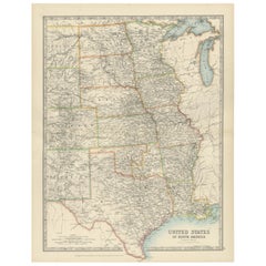
Map of the Southeastern USA and Atlantic States – Vintage 1903 Geography
$407.11
£300.95
€340
CA$553.70
A$620.42
CHF 322.95
MX$7,589.92
NOK 4,099.30
SEK 3,871.74
DKK 2,588.93
Shipping
Retrieving quote...The 1stDibs Promise:
Authenticity Guarantee,
Money-Back Guarantee,
24-Hour Cancellation
About the Item
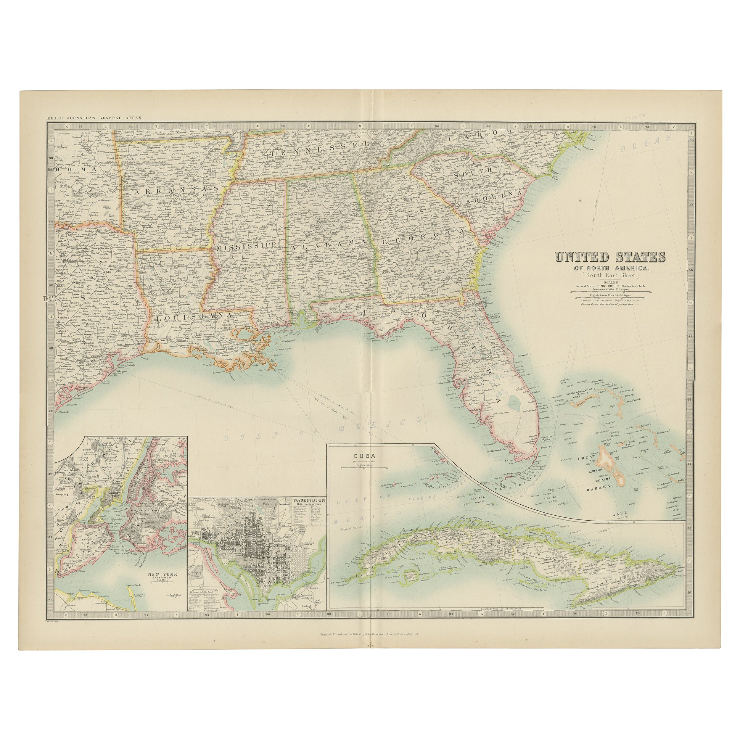
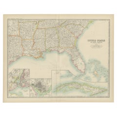
Map of the Southeastern USA and Atlantic States – Vintage 1903 Geography
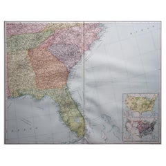
This original engraved map, titled “United States of North America (South Eastern Sheet) with the Atlantic States,” was meticulously prepared by Keith Johnston and published in the early 1900s. It offers an intricately detailed representation of the southeastern region of the United States, including the Gulf of Mexico, the southern Atlantic coast, and the states of Georgia, Alabama, Mississippi, Louisiana, Florida, South Carolina, North Carolina, Tennessee, and beyond. An inset map captures the urban areas of Boston and Philadelphia with fine clarity, providing additional historical perspective on these prominent cities during the early 20th century.
The cartographic detail is impressive, showcasing not only state boundaries but also county divisions, major railroads, rivers, and mountain ranges, all in beautifully engraved lines with color outlining the states. The typography is precise and easy to read, adding a decorative touch to the map’s historical character. With the Atlantic Ocean labeled in classic script and the inclusion of neighboring Bahama Islands, this map gives a comprehensive view of trade routes and maritime significance during that period.
Condition is excellent for its age, with only minor aging or marginal imperfections that do not detract from its presentation. The engraved lines and colored boundaries remain vivid, offering a crisp visual appeal perfect for display or collection.
This map would look splendid framed in a classic or antique-style wooden frame, perhaps with a warm, natural finish to complement the vintage aesthetic. For the mat, consider cream or off-white to highlight the fine engraving. Ideal for anyone with a passion for American history, cartography, or antique décor, this map stands as both a piece of art and a window into the past.
- Dimensions:Height: 14.49 in (36.8 cm)Width: 18.51 in (47 cm)Depth: 0.01 in (0.2 mm)
- Materials and Techniques:
- Period:
- Date of Manufacture:1903
- Condition:Condition is excellent for its age, with only minor aging or marginal imperfections that do not detract from its presentation. The engraved lines and colored boundaries remain vivid, offering a crisp visual appeal perfect for display or collection.
- Seller Location:Langweer, NL
- Reference Number:Seller: BG-13577-461stDibs: LU3054345291802
About the Seller
5.0
Recognized Seller
These prestigious sellers are industry leaders and represent the highest echelon for item quality and design.
Platinum Seller
Premium sellers with a 4.7+ rating and 24-hour response times
Established in 2009
1stDibs seller since 2017
2,493 sales on 1stDibs
Typical response time: <1 hour
- ShippingRetrieving quote...Shipping from: Langweer, Netherlands
- Return Policy
Authenticity Guarantee
In the unlikely event there’s an issue with an item’s authenticity, contact us within 1 year for a full refund. DetailsMoney-Back Guarantee
If your item is not as described, is damaged in transit, or does not arrive, contact us within 7 days for a full refund. Details24-Hour Cancellation
You have a 24-hour grace period in which to reconsider your purchase, with no questions asked.Vetted Professional Sellers
Our world-class sellers must adhere to strict standards for service and quality, maintaining the integrity of our listings.Price-Match Guarantee
If you find that a seller listed the same item for a lower price elsewhere, we’ll match it.Trusted Global Delivery
Our best-in-class carrier network provides specialized shipping options worldwide, including custom delivery.More From This Seller
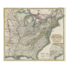
View AllAntique Map of the United States ' South East ' by Johnston '1909'
Located in Langweer, NL
Antique map titled 'United States of North America'. Original antique map of United States of North America ( South East Sheet ). With in...
Category
Early 20th Century Maps
Materials
Paper
$335 Sale Price
20% Off
Antique Map of the United States of North America, c.1882
Located in Langweer, NL
Antique map titled 'United States of North America'. Old map of the United States of North America. This map originates from 'The Royal Atlas of Modern Geography, Exhibiting, in a Se...
Category
Antique 1880s Maps
Materials
Paper

$335 Sale Price
20% Off
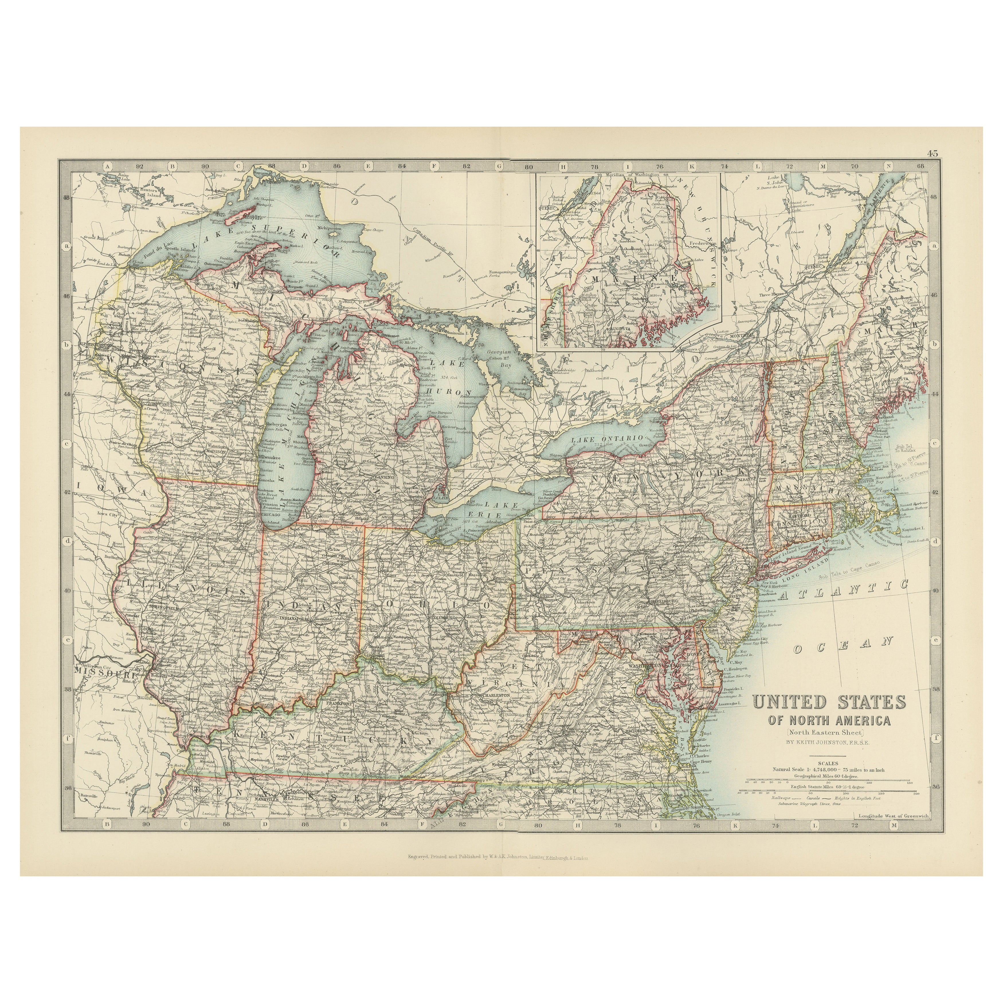
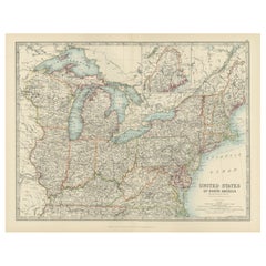
Antique Map of the Northeast USA - Vibrant 1903 Cartographic Detail
Located in Langweer, NL
Map of the Northeastern United States of North America, 1903
This striking antique map titled “United States of North America (North Eastern Sheet)” was created by the renowned Scot...
Category
Early 20th Century Maps
Materials
Paper
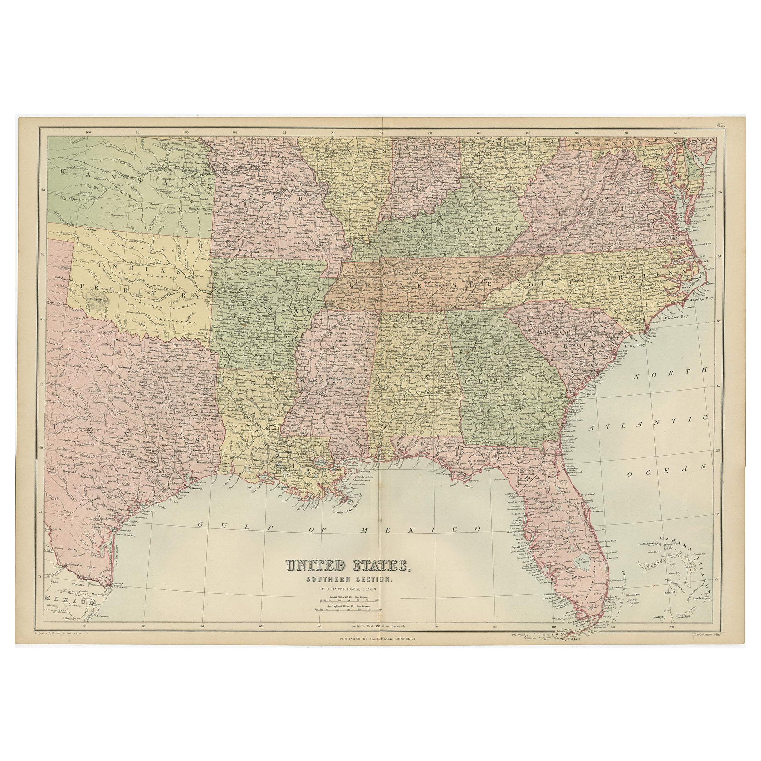
Antique Map of The United States Southern Section by A & C. Black, 1870
Located in Langweer, NL
Antique map titled 'United States Southern Section'. Original antique map of Map of The United States Southern Section. This map originates from ‘Black's General Atlas of The World’....
Category
Antique Late 19th Century Maps
Materials
Paper

$239 Sale Price
20% Off
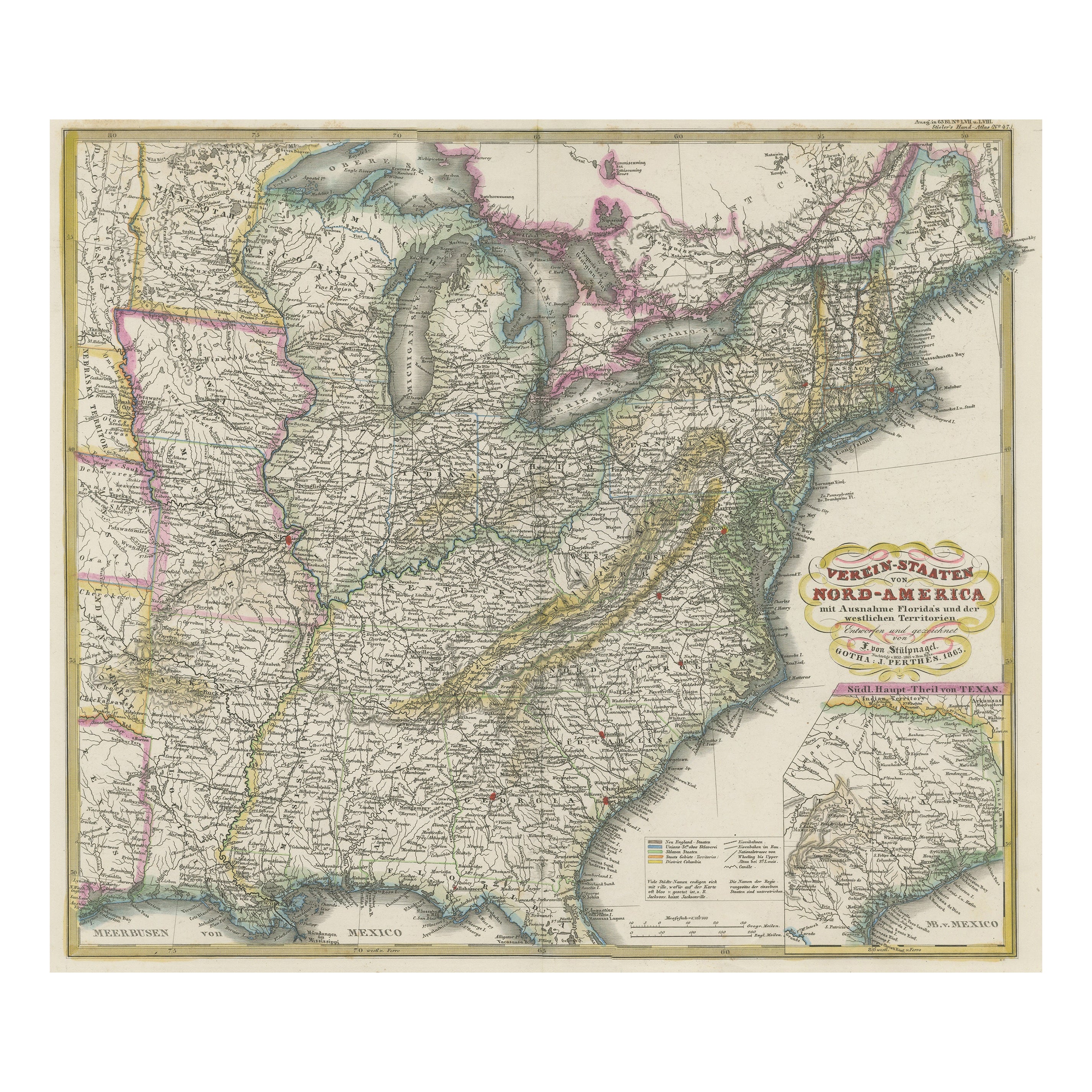
Antique Map of the Eastern United States with Only the Northern Part of Florida
Located in Langweer, NL
Antique map titled 'Verein-Staaten von Nord-America mit Ausnahme Florida's und der Westlichen Territorien'. This map extends as far west as Louisiana and only includes the northern p...
Category
Antique Mid-19th Century Maps
Materials
Paper
$785 Sale Price
20% Off
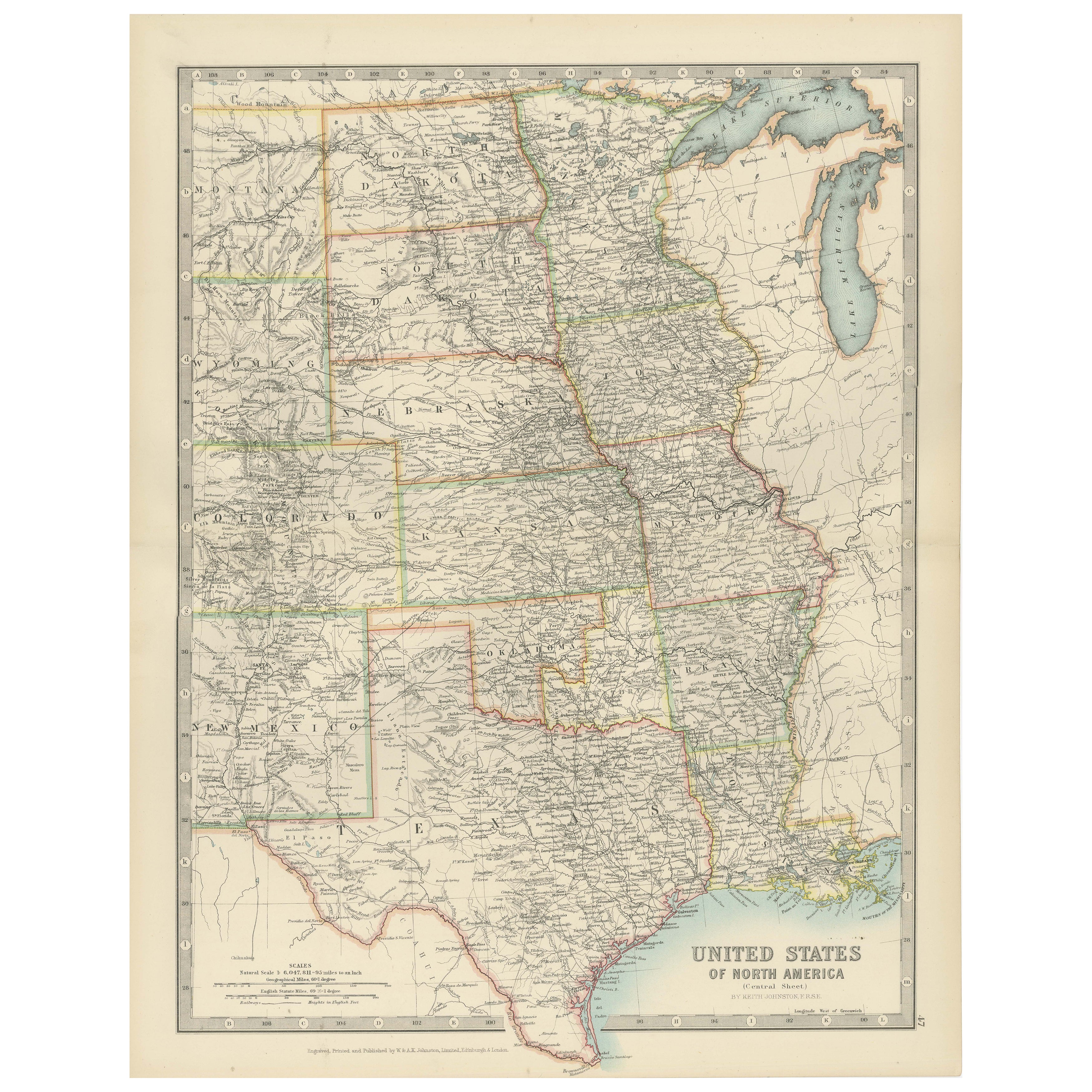
Map of United States Central Sheet 1903 – Railroads, States, and Topography
Located in Langweer, NL
Map of United States Central Sheet 1903 – Railroads, States, and Topography
This is a finely engraved and beautifully colored map titled "United States of North America (Central She...
Category
Early 20th Century Maps
Materials
Paper
You May Also Like
Large Original Vintage Map of the South Eastern States Inc. Florida, circa 1920
Located in St Annes, Lancashire
Great map of The South Eastern States
Original color. Good condition
Published by Alexander Gross
Unframed.
Category
Vintage 1920s English Maps
Materials
Paper
Florida. USA Century Atlas state antique vintage map
Located in Melbourne, Victoria
'The Century Atlas. Florida'
Original antique map, 1903.
Central fold as issued. Map name and number printed on the reverse corners.
Sheet 40cm by 29.5cm.
Category
Early 20th Century Victorian More Prints
Materials
Lithograph
Original Antique Map of United States, Grattan and Gilbert, 1843
Located in St Annes, Lancashire
Great map of United States
Drawn and engraved by Archer
Published by Grattan and Gilbert. 1843
Original colour
Unframed.
Category
Antique 1840s English Maps
Materials
Paper

Original Antique Map of The United States of America by Dower, circa 1835
Located in St Annes, Lancashire
Nice map of the USA
Drawn and engraved by J.Dower
Published by Orr & Smith. C.1835
Unframed.
Free shipping
Category
Antique 1830s English Maps
Materials
Paper

Large Original Vintage Map of North America, circa 1920
Located in St Annes, Lancashire
Great map of North America
Original color. Good condition
Published by Alexander Gross
Unframed.
Category
Vintage 1920s English Edwardian Maps
Materials
Paper

North America. Century Atlas antique vintage map
Located in Melbourne, Victoria
'The Century Atlas. North America'
Original antique map, 1903.
Central fold as issued. Map name and number printed on the reverse corners.
Sheet 40cm by 29.5cm.
Category
Early 20th Century Victorian More Prints
Materials
Lithograph

More Ways To Browse
Antique Script
Louisiana Antique Furniture
Tennessee Antique Furniture
Antique Furniture South Carolina
6x10 Rug
Styles Of Antique Desks
Black And White Coffee Table
Metal Relief
Curved Velvet Couch
Velvet Curved Sofa
Wood Round Coffee Tables
Antique Paper Flowers
Oak Brutalist
Used College Furniture
Wood Minimalist Chair
2002 Lamp
Antique Imperial Furniture
Gold Modern Coffee Table