Items Similar to Antique Map of the United States of North America, c.1882


Want more images or videos?
Request additional images or videos from the seller
1 of 5
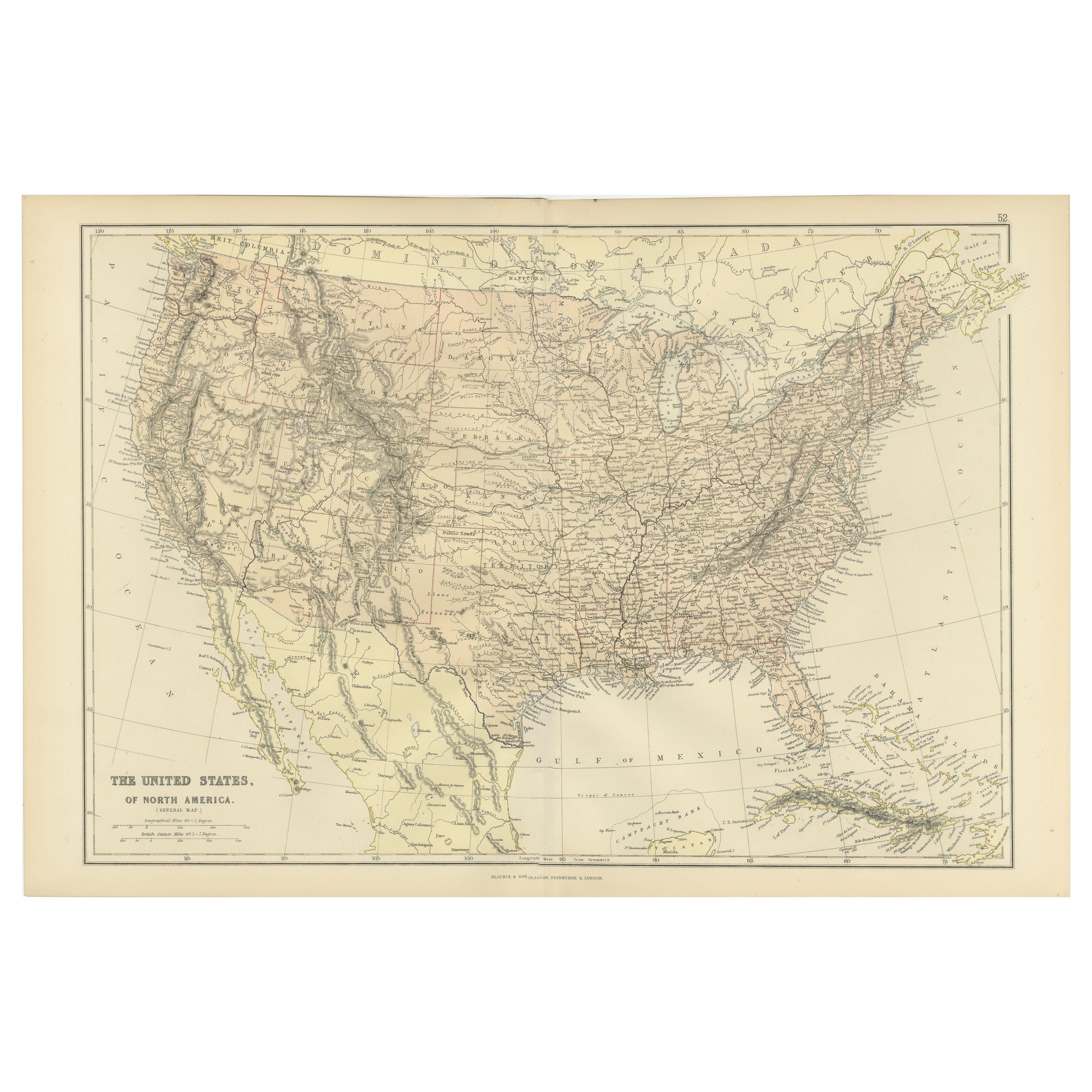
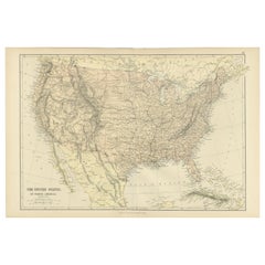
Antique Map of the United States of North America, c.1882
About the Item
Antique map titled 'United States of North America'. Old map of the United States of North America. This map originates from 'The Royal Atlas of Modern Geography, Exhibiting, in a Series of Entirely Original and Authentic Maps, the Present Condition of Geographical Discovery and Research in the Several Countries, Empires, and States of the World' by A.K. Johnston. Published by W. and A.K. Johnston, 1882.
Artists and Engravers: Alexander Keith Johnston LLD (1804-1871) was a Scottish geographer. He was a pupil of the Edinburgh engraver and mapmaker, James Kirkwood. In 1826, he joined his brother William (who would become Sir William Johnston, Lord Provost of Edinburgh) in a printing and engraving business, forming the well-known cartographical firm of W. and A. K. Johnston.
Condition: Good, general age-related toning. Please study image carefully.
- Dimensions:Height: 24.22 in (61.5 cm)Width: 19.49 in (49.5 cm)Depth: 0 in (0.02 mm)
- Materials and Techniques:
- Period:
- Date of Manufacture:1882
- Condition:
- Seller Location:Langweer, NL
- Reference Number:
About the Seller
5.0
Platinum Seller
These expertly vetted sellers are 1stDibs' most experienced sellers and are rated highest by our customers.
Established in 2009
1stDibs seller since 2017
1,947 sales on 1stDibs
Typical response time: <1 hour
- ShippingRetrieving quote...Ships From: Langweer, Netherlands
- Return PolicyA return for this item may be initiated within 14 days of delivery.
More From This SellerView All
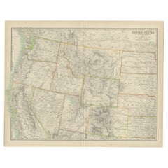
- Antique Map of The United States of North America, 1882Located in Langweer, NLThis is a historical map titled "The United States of North America, Central Part" from the 1882 Blackie Atlas. It depicts the continental United States with a high level of detail, ...Category
Antique 1880s Maps
MaterialsPaper
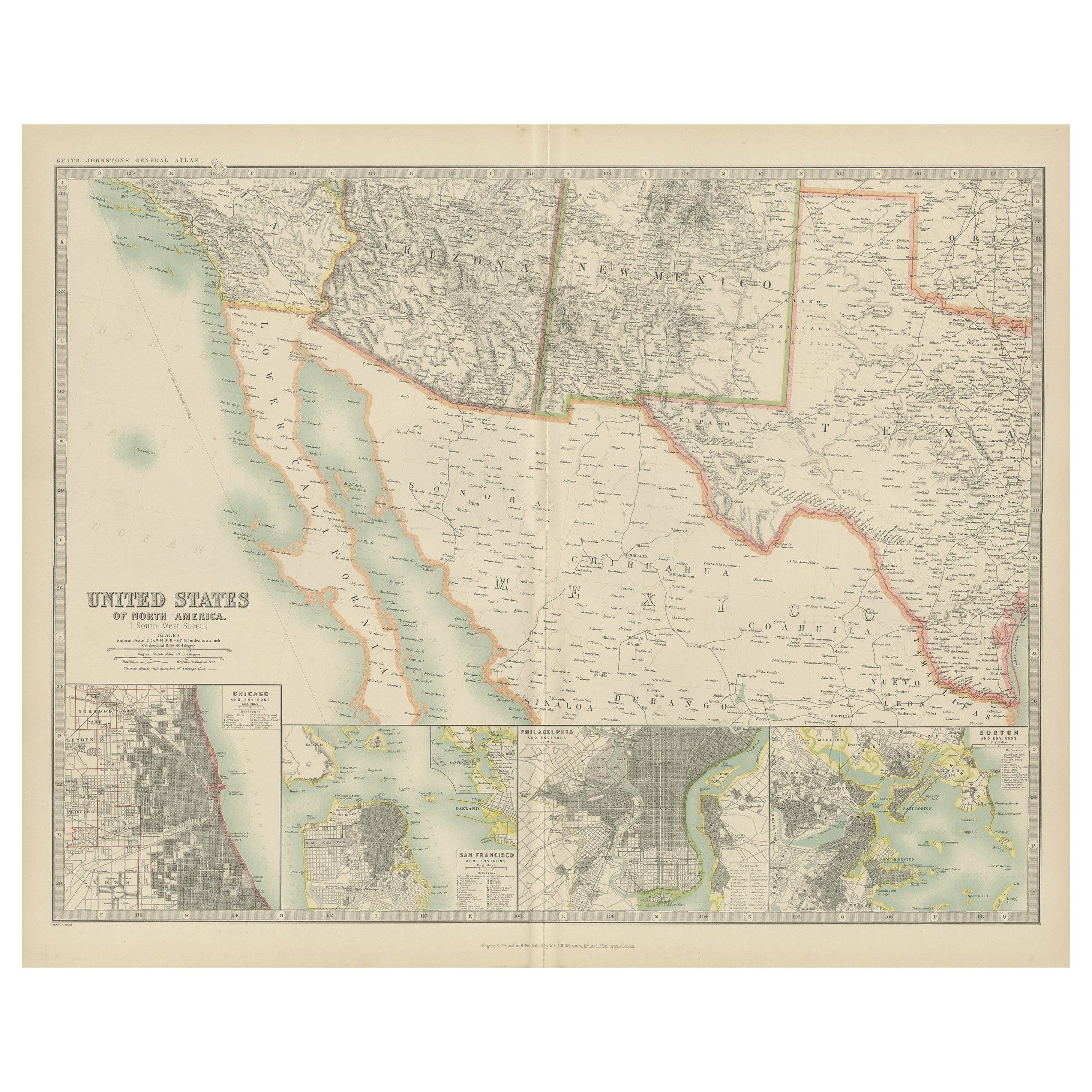
- Antique Map of the United States of North America by Johnston '1909'Located in Langweer, NLAntique map titled 'United States of North America'. Original antique map of United States of North America ( South West Sheet ). With inset maps of Chicago...Category
Early 20th Century Maps
MaterialsPaper
- Antique Map of the United States of North America by Wyld '1845'Located in Langweer, NLAntique map titled 'Map of The United States of North America'. Original antique map of the United States of North America. This map originates from 'An Atlas of the World, Comprehen...Category
Antique Mid-19th Century Maps
MaterialsPaper
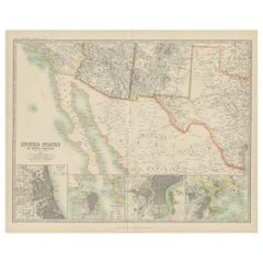
- Antique Map of The United States of North America, Pacific States, 1882Located in Langweer, NLThe map is from the same 1882 Blackie Atlas and focuses on the Pacific States of the United States of America during that period. Here are some details and historical context about t...Category
Antique 1880s Maps
MaterialsPaper
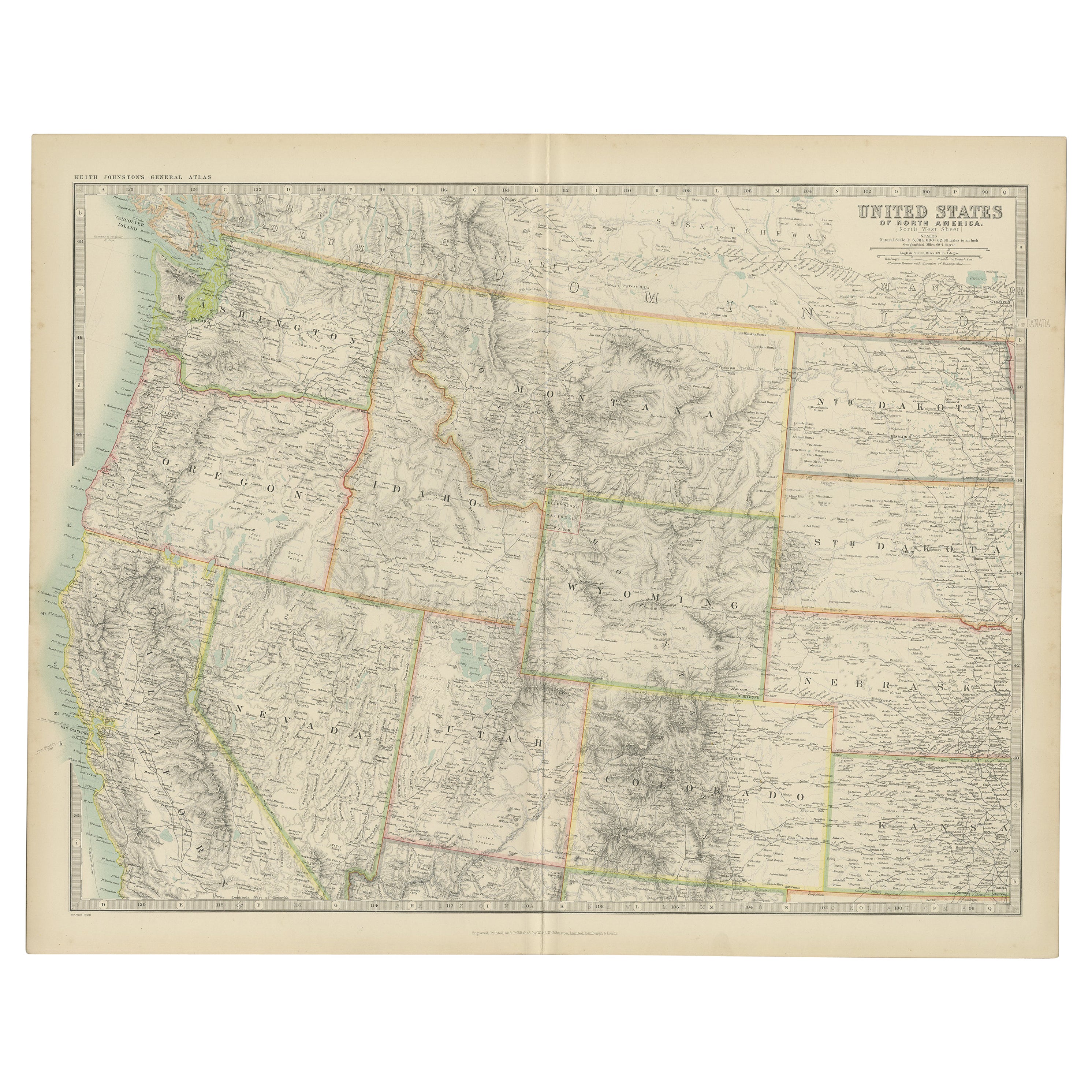
- Antique Map of the United States 'North West' by Johnston, '1909'Located in Langweer, NLAntique map titled 'United States of North America'. Original antique map of the United States of North America ( North West ). This map originates from the ‘Royal Atlas of Modern Ge...Category
Early 20th Century Maps
MaterialsPaper
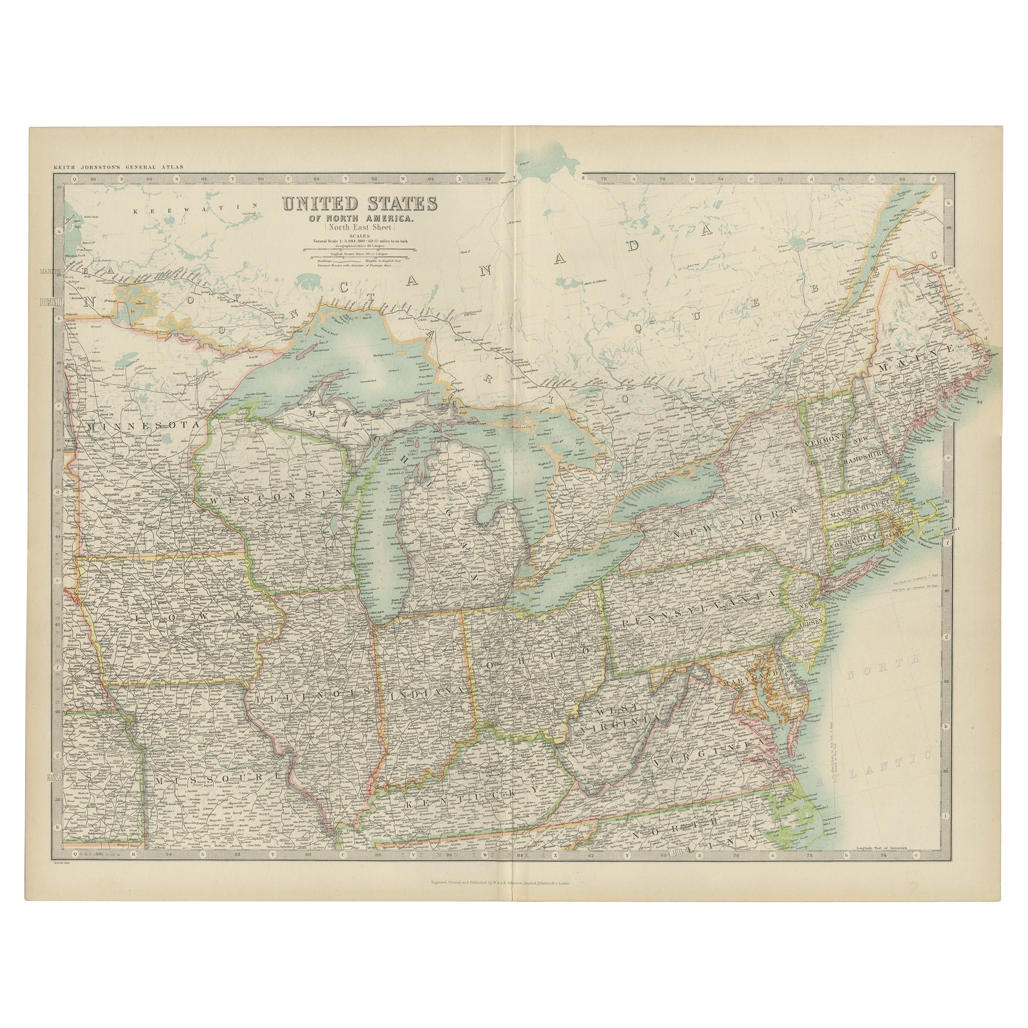
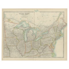
- Antique Map of the United States ' North East ' by Johnston '1909'Located in Langweer, NLAntique map titled 'United States of North America'. Original antique map of United States of North America ( North East ). This map orig...Category
Early 20th Century Maps
MaterialsPaper


You May Also Like
- Original Antique Map of United States, Grattan and Gilbert, 1843Located in St Annes, LancashireGreat map of United States Drawn and engraved by Archer Published by Grattan and Gilbert. 1843 Original colour Unframed.Category
Antique 1840s English Maps
MaterialsPaper
- Large Antique 1859 Map of North AmericaLocated in Sag Harbor, NYThis Map was made by Augustus Mitchell in 1859 It is in amazing condition for being 163 years old. This price is for the rolled up easy to ship version of this piece. I will be Frami...Category
Antique Mid-19th Century American Maps
MaterialsCanvas, Paper

- New Map of North America from the Latest Discoveries, 1763Located in Philadelphia, PAA fine antique 18th century map of the North American seaboard. Entitled "A New Map of North America from the Latest Discoveries 1763". By the Cartographer/Engraver - John Spil...Category
Antique Mid-18th Century English Georgian Maps
MaterialsPaper
- Large Original Antique Map of the United States of America. 1891By Rand McNally & Co.Located in St Annes, LancashireFabulous map of The United States Original color By Rand, McNally & Co. Dated 1891 Unframed Free shipping.Category
Antique 1890s American Maps
MaterialsPaper
- Original Antique Map of The United States of America, circa 1890Located in St Annes, LancashireGreat map of the USA By The Stanford's Geographical Establishment Original colour Unframed.Category
Antique 1890s English Victorian Maps
MaterialsPaper
- 1859 "Map of the United States of America..." by J. H. ColtonBy J.H. ColtonLocated in Colorado Springs, COPresented is an 1859 “Map of the United States of America, the British Provinces, Mexico, the West Indies and Central America with Part of...Category
Antique 1850s American Maps
MaterialsPaper


Recently Viewed
View AllMore Ways To Browse
Antique Furniture United States
Antique United States
American Empire Antiques
Map North America
Antique Maps Of United States
Map Of North America
Antique Maps Of States
Used Office Furniture Edinburgh
Antique Map Of The United States
Antique Maps Of The United States
Alexander James
Scotland Map
Old American Maps
General Empire
Antique Map Scotland
Antique Map Of Scotland
Antique Maps Scotland
Scotland Antique Map