Items Similar to New Map of North America from the Latest Discoveries, 1763


Want more images or videos?
Request additional images or videos from the seller
1 of 17
New Map of North America from the Latest Discoveries, 1763
About the Item
A fine antique 18th century map of the North American seaboard.
Entitled "A New Map of North America from the Latest Discoveries 1763".
By the Cartographer/Engraver - John Spilsbury, 1739-1769.
Depicting the British Colonies in North America at the end of the French & Indian War.
The claims of the Carolinas, Virginia, and New England have extend westward towards the Pacific Ocean. Georgia is now shown along with many Indian regions, and the Earl of Granville's line and the Florida/Carolina border is also shown.
Publisher: London magazine, v. 32, 1763.
Housed in a thin gilt wooden Neoclassical frame, triple matted, and housed behind what we believe is UV protective plexiglass.
There is a tear, staining and some apparent loss to the western latitudinal guide.
Simply a great historical map that predates the United States!
Date:
1763
Overall Condition:
It is in overall good, as-pictured, used estate condition.
Condition Details:
There seems to be some yellowing and past acid burn to the edges, a few spots of foxing, and expected folds and creasing throughout. There is a small tear, staining and some a lack of margin paper to the western latitudinal guide (which seems to be typical of this map).
Not observed outside the frame
The frame is in good condition with some spots of loss its gilding, nicks, and some spots of edge wear here & there. There are some scratches to what appears to be (UV protective) plexiglass housing the mat. Otherwise, there are some fine & light surface scratches and other signs of expected light wear consistent with age.
Measurements:
Width: ca. 25 7/8 in.
Height: ca. 22 in.
Depth: ca. 1 in.
Sight width: ca. 16 in.
Sight height: ca. 11 1/2 in.
Items purchased from this dealer must delight you. Purchases may be returned for any reason for a period of 7 days.
- Dimensions:Height: 22 in (55.88 cm)Width: 25.88 in (65.74 cm)Depth: 1 in (2.54 cm)
- Style:Georgian (Of the Period)
- Materials and Techniques:
- Place of Origin:
- Period:
- Date of Manufacture:1763
- Condition:Wear consistent with age and use. See description for condition details.
- Seller Location:Philadelphia, PA
- Reference Number:
About the Seller
5.0
Gold Seller
These expertly vetted sellers are highly rated and consistently exceed customer expectations.
Established in 1996
1stDibs seller since 2015
403 sales on 1stDibs
Typical response time: 1 hour
- ShippingRetrieving quote...Ships From: Philadelphia, PA
- Return PolicyA return for this item may be initiated within 7 days of delivery.
More From This SellerView All
- Antique 18th Century Map of the Province of Pensilvania 'Pennsylvania State'Located in Philadelphia, PAA fine antique of the colony of Pennsylvania. Noted at the top of the sheet as a 'Map of the province of Pensilvania'. This undated and anonymous map is thought to be from the Gentleman's Magazine, London, circa 1775, although the general appearance could date it to the 1760's. The southern boundary reflects the Mason-Dixon survey (1768), the western boundary is placed just west of Pittsburgh, and the northern boundary is not marked. The map has a number of reference points that likely refer to companion text and appear to be connected to boundaries. The western and southern boundaries are marked Q, R, S, for example. A diagonal line runs from the Susquehanna R to the Lake Erie P. A broken line marked by many letters A, B, N, O, etc., appears in the east. There are no latitude or longitude markings, blank verso. Framed in a shaped contemporary gilt wooden frame and matted under a cream colored matte. Bearing an old Graham Arader Gallery...Category
Antique 18th Century British American Colonial Maps
MaterialsPaper
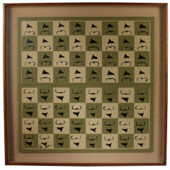
- Chessboard "Homaage á Marcel Duchamp" with the L.H.O.O.Q. Mustache by ArmanBy ArmanLocated in Philadelphia, PAA shadow-box framed chessboard with the L.H.O.O.Q. mustache by Arman (1928-2005) entitled "Homaage á Marcel Duchamp". A screen-print on Skivertex leather chessboard. Framed behin...Category
Vintage 1970s American Modern Prints
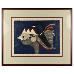
- Woodblock Print of a Javanese Puppet on Blue Ground by Kiyoshi Saito, 1950sBy Kiyoshi SaitōLocated in Philadelphia, PAA fine woodblock print of a Javanese puppet in profile. The imagery is a potent mixture of Saito's traditional Japanese sensibilities coupled with...Category
Mid-20th Century Japanese Mid-Century Modern Prints
MaterialsPaper
- Einstein State I, a Pop-Art Screen-Print of Albert Einstein by Sak Steve KaufmanBy Steve KaufmanLocated in Philadelphia, PATitle: Einstein State I (with embellishments). By: Steve Kaufman. Date: 1990s. A limited edition screen-print on canvas with hand embellishments (in oil). Depicting Alber...Category
Late 20th Century American Post-Modern Paintings
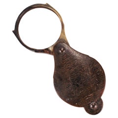
- Antique 18th or Early 19th Century Horn Folding Magnifying Glass or LoupeLocated in Philadelphia, PAA fine antique magnifying glass or loupe. The frame comprised of horn (likely from a steer or ram). The magnifying glass is be rotated in and out of the cover protecting the lens while not in use. Simply a great antique magnifier...Category
Antique Early 19th Century Unknown George III Scientific Instruments
MaterialsHorn, Glass
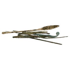
- Group of Ancient Roman Bronze Tools & Hair PinsLocated in Philadelphia, PAA fine group of ancient Roman bronze implements and artifacts. Consisting of pins & several small scale tools. From the private collection of Lawrence Majewski, who was a former co...Category
Antique 15th Century and Earlier Italian Classical Roman Antiquities
MaterialsBronze


You May Also Like
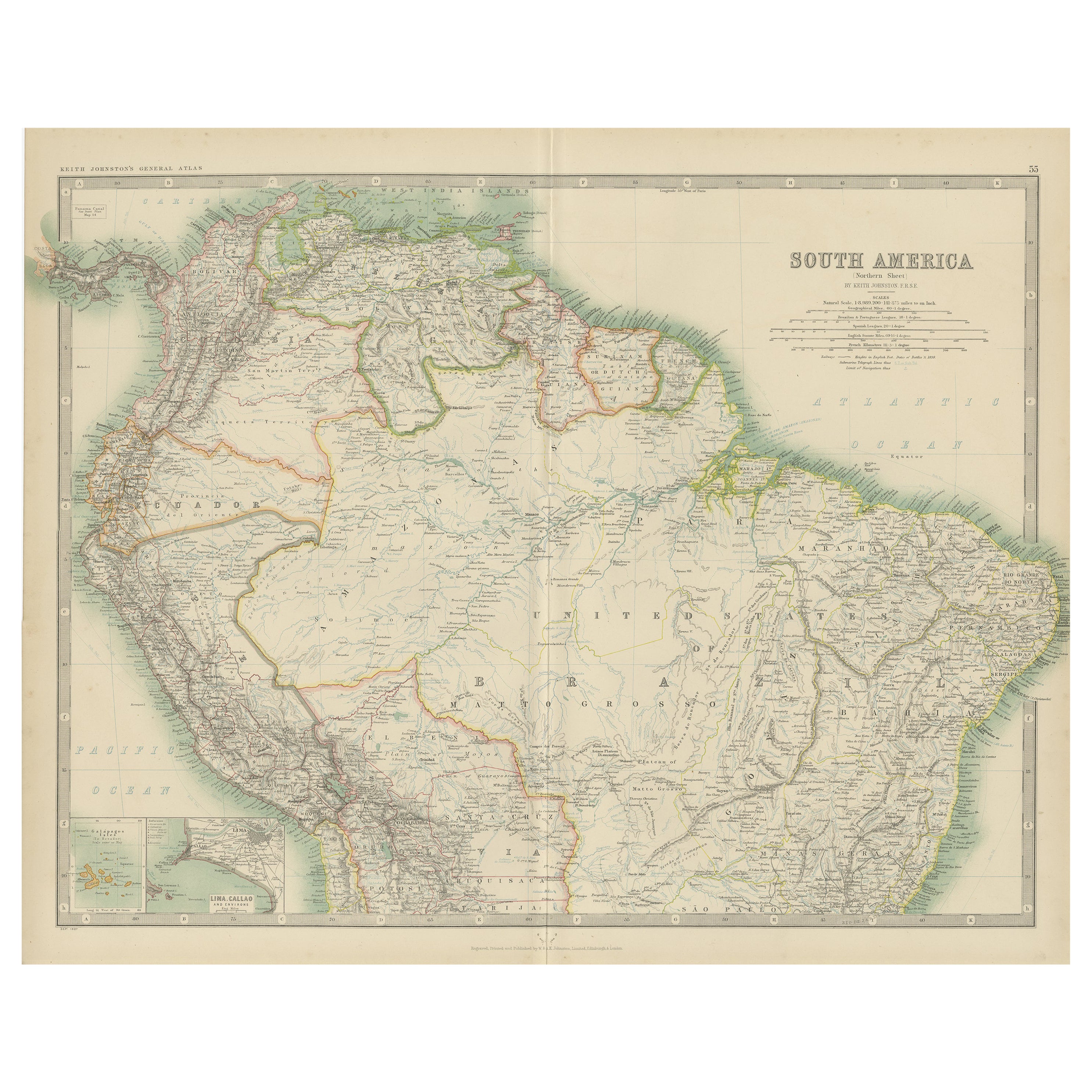
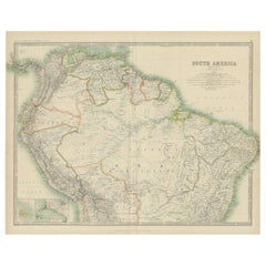
- Exploring South America's North: Antique Map from the Royal Atlas of 1909Located in Langweer, NLThe antique map titled 'South America, Northern Sheet' is a historical cartographic representation of the northern part of South America. This original antique map features inset map...Category
Early 20th Century Maps
MaterialsPaper
- Antique Map of North America, 1821Located in Langweer, NLAntique map of America titled 'Carte de l'Amerique septentrionale'. Scarce map of North America, shortly after the Louisiana Purchase and the first ...Category
Antique 19th Century Maps
MaterialsPaper
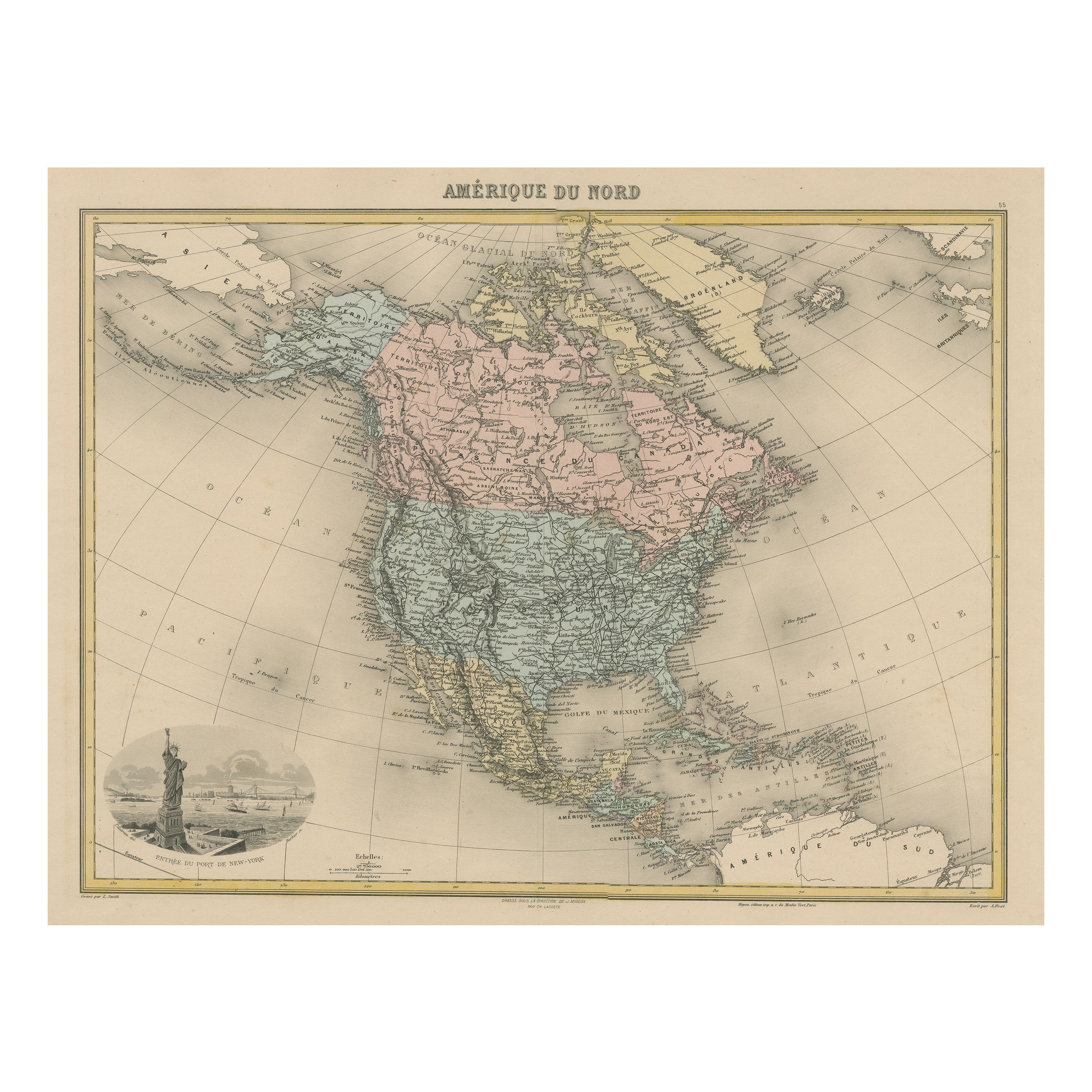
- Antique Map of North America with Vignette of the Statue of Liberty, New YorkLocated in Langweer, NLAntique map titled 'Amérique du Nord'. Original antique map of North America. Meticulous information from the new Alaska Territory and through the Caribbean Windward Islands. Very go...Category
Antique Late 19th Century Maps
MaterialsPaper
- Antique Map of the United States of North America, c.1882Located in Langweer, NLAntique map titled 'United States of North America'. Old map of the United States of North America. This map originates from 'The Royal Atlas of Modern Geography, Exhibiting, in a Se...Category
Antique 1880s Maps
MaterialsPaper
- Antique Map of North America Including the West IndiesLocated in Langweer, NLOriginal antique map titled 'Nord-America'. Old map of North America and the West Indies. Also showing British Overseas Territories and Hudson Bay. This map originates from Stiel...Category
Antique Mid-19th Century Maps
MaterialsPaper
- Antique Map of the West Coast of North America & North East Coast of Asia '1772'Located in Langweer, NLAntique map titled 'Carte des nouvelles decouvertes/ Extrait d'une Carte Japonoise de l'Universe'. Map of the West Coast of North America and North-East Coast of Asia, based upon Buache's report of the various Russian Discoveries between 1731 and 1742 including the various explorers routes and notes. The lower map is based upon a Japanese map...Category
Antique Late 18th Century Maps
MaterialsPaper


Recently Viewed
View AllMore Ways To Browse
Antique Furniture From New England
North Carolina Furniture
North American Indian
American Georgian Furniture
Antique Spot Light
North Carolina Mid Century
Antique Furniture In Virginia
Carolina Antique
American Antique Picture Frames
Georgian Wooden
Antique Indian Furniture London
Indian Tears
French Line Ocean
Antique Picture Frames Collectibles
Antique War Map
Gilt Georgian Frame
Indian Antique Wooden
Earl North