Items Similar to Map of Tasmania with Illustrations of Local Fauna and Colonial Landmarks, 1851


Want more images or videos?
Request additional images or videos from the seller
1 of 6
Map of Tasmania with Illustrations of Local Fauna and Colonial Landmarks, 1851
$277.97
$347.4620% Off
£206.89
£258.6120% Off
€232
€29020% Off
CA$380.75
CA$475.9420% Off
A$423.48
A$529.3420% Off
CHF 221.13
CHF 276.4120% Off
MX$5,153.25
MX$6,441.5620% Off
NOK 2,824.11
NOK 3,530.1420% Off
SEK 2,648.52
SEK 3,310.6520% Off
DKK 1,766.14
DKK 2,207.6720% Off
Shipping
Retrieving quote...The 1stDibs Promise:
Authenticity Guarantee,
Money-Back Guarantee,
24-Hour Cancellation
About the Item
John Tallis & Company was renowned for their detailed and ornate maps during the 19th century. Their maps are distinguished by the intricate borders and vignettes that are as informative as they are decorative.
The map is of Tasmania, known at the time as Van Diemen's Land, which was a significant British colony. Tasmania was an important outpost of the British Empire, largely due to its use as a penal colony, its strategic location, and its natural resources.
Robert Montgomery Martin's texts accompanying such maps often provided detailed descriptions of the colonial economies, geography, and insights into the British perspective on these distant territories. His work was a reflection of the Victorian era’s interest in the empire and its desire to document and understand its distant lands.
The countries and areas depicted in the Tallis series, like Tasmania, would be illustrated with great attention to detail. Key landmarks, topography, and regional borders would be carefully delineated. Insets on this map of Tasmania, for instance, may feature Hobart Town, which was a major administrative center, and might also include other significant locales or aspects of local interest such as fauna, flora, and important buildings.
The Tallis series serves as a visual record of the time, showcasing the British Empire’s reach and the period's aesthetic in map-making. These maps are now valuable historical documents, revealing how the British perceived and interacted with their colonies, and they are sought after for their combination of artistic merit and historical significance.
The images in more detail:
The images are detailed illustrations that complement the cartography of the Tallis map of Tasmania, providing a richer context of the island's features and colonial life:
1. **Thylacinus cynocephalus**: Also known as the Tasmanian tiger or thylacine, this image depicts the now-extinct carnivorous marsupial that was native to Tasmania. It is shown in a naturalistic pose, possibly on a rock or hill, set against a backdrop of sparse vegetation, symbolizing its existence in the wild Tasmanian landscape.
2. **Residence of the V.D.L. Company's Agent, Circular Head**: This vignette illustrates a stately residence, likely belonging to an agent of the Van Diemen's Land Company, a powerful agricultural company. The image shows a grand home surrounded by gardens, indicating the wealth and influence of the company within the colony. People are depicted strolling near the residence, suggesting a tranquil life away from the mainland's bustle.
3. **Hobart Town**: This illustration likely captures the early colonial period of Hobart, the capital city of Tasmania. It presents a view of the city from the water, showcasing the town's port with ships anchored in the bay, Mount Wellington in the background, and the city's buildings spreading out from the waterfront, indicating its status as a bustling port and administrative center.
These images serve not only as aesthetic enhancements to the map but also provide insights into the natural history and colonial development of Tasmania during the 19th century.
- Dimensions:Height: 14.26 in (36.2 cm)Width: 10.71 in (27.2 cm)Depth: 0 in (0.02 mm)
- Materials and Techniques:
- Period:
- Date of Manufacture:1851
- Condition:Good given age. Original fold in middle as published. General age-related toning, please study scan carefully.
- Seller Location:Langweer, NL
- Reference Number:Seller: BG-13736-111stDibs: LU3054339297612
About the Seller
5.0
Recognized Seller
These prestigious sellers are industry leaders and represent the highest echelon for item quality and design.
Platinum Seller
Premium sellers with a 4.7+ rating and 24-hour response times
Established in 2009
1stDibs seller since 2017
2,502 sales on 1stDibs
Typical response time: <1 hour
- ShippingRetrieving quote...Shipping from: Langweer, Netherlands
- Return Policy
Authenticity Guarantee
In the unlikely event there’s an issue with an item’s authenticity, contact us within 1 year for a full refund. DetailsMoney-Back Guarantee
If your item is not as described, is damaged in transit, or does not arrive, contact us within 7 days for a full refund. Details24-Hour Cancellation
You have a 24-hour grace period in which to reconsider your purchase, with no questions asked.Vetted Professional Sellers
Our world-class sellers must adhere to strict standards for service and quality, maintaining the integrity of our listings.Price-Match Guarantee
If you find that a seller listed the same item for a lower price elsewhere, we’ll match it.Trusted Global Delivery
Our best-in-class carrier network provides specialized shipping options worldwide, including custom delivery.More From This Seller
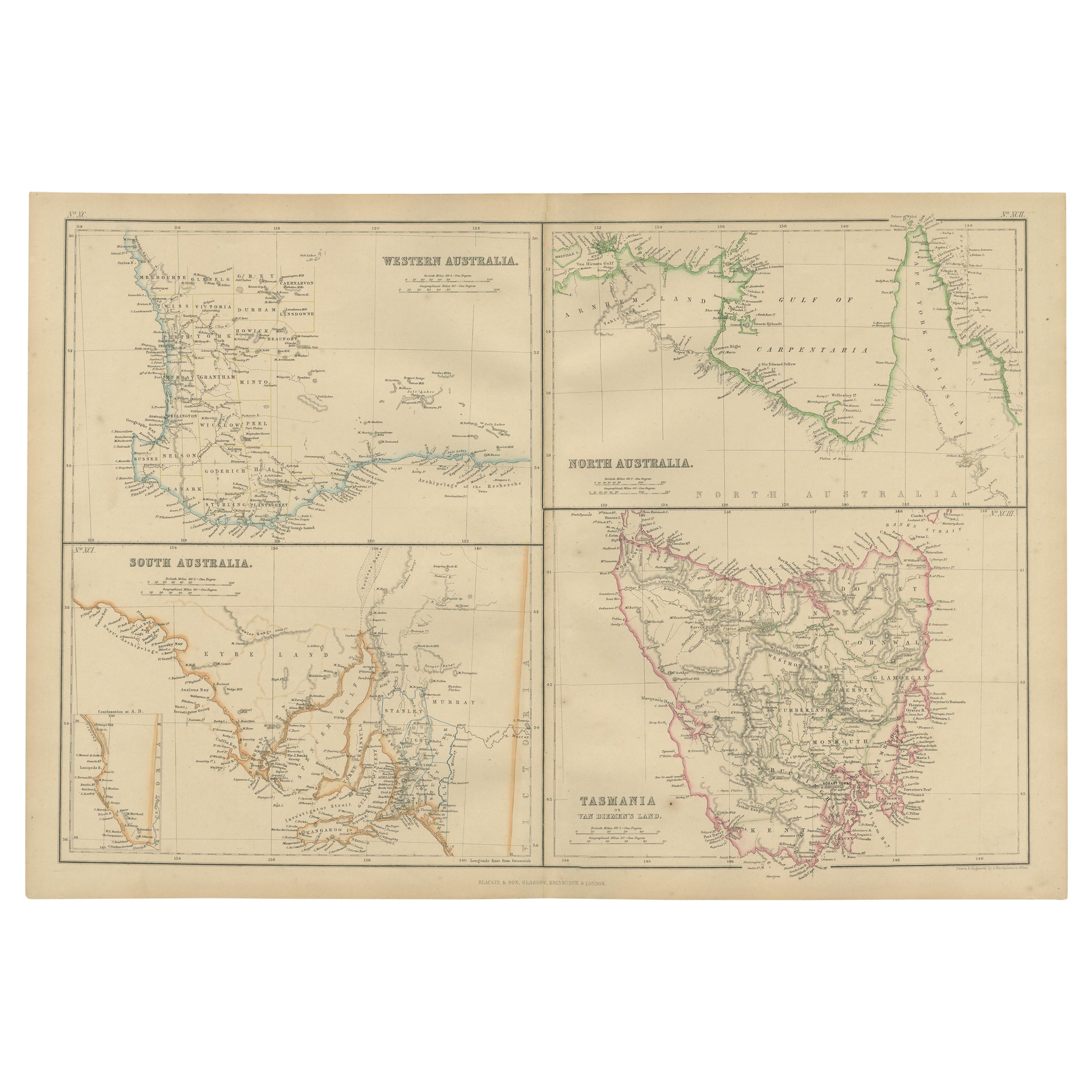
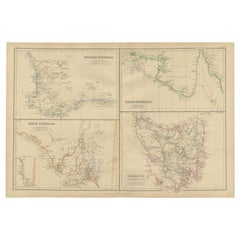
View AllAntique Map of West, South, North Australia and Tasmania by W. G. Blackie, 1859
Located in Langweer, NL
Antique map titled 'Western Australia, South Australia, North Australia and Tasmania'. Original antique map of Western Australia, South Australia, North Australia and Tasmania. This ...
Category
Antique Mid-19th Century Maps
Materials
Paper
$239 Sale Price
20% Off
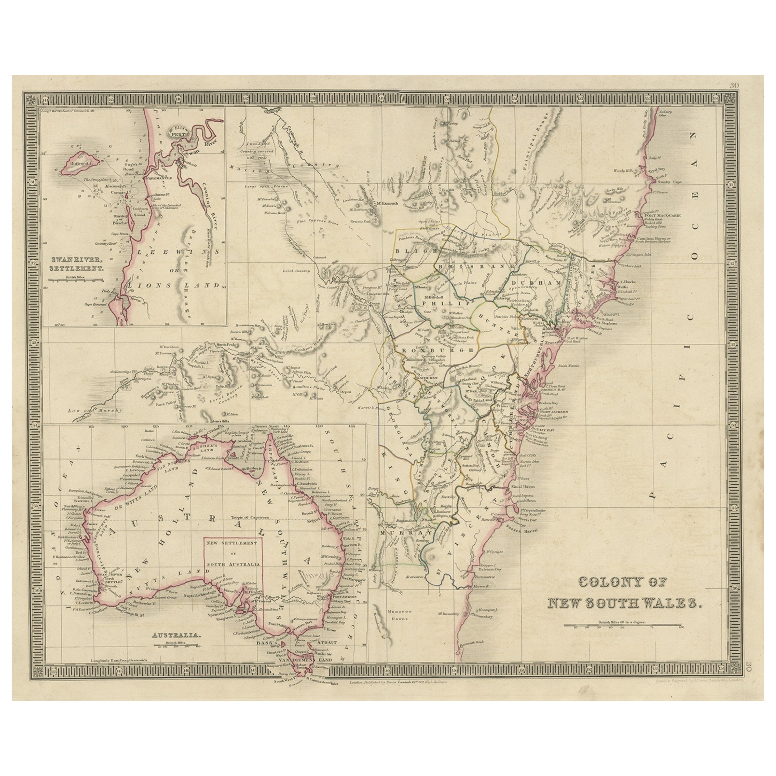
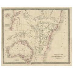
Antique Map of New South Wales with Inset Maps of Australia and Swan River, 1854
Located in Langweer, NL
Antique map titled 'Colony of New South Wales'. Map of New South Wales with inset maps of Australia and Swan River. Artists and Engravers: Drawn and engrave...
Category
Antique 19th Century Maps
Materials
Paper
$306 Sale Price
20% Off
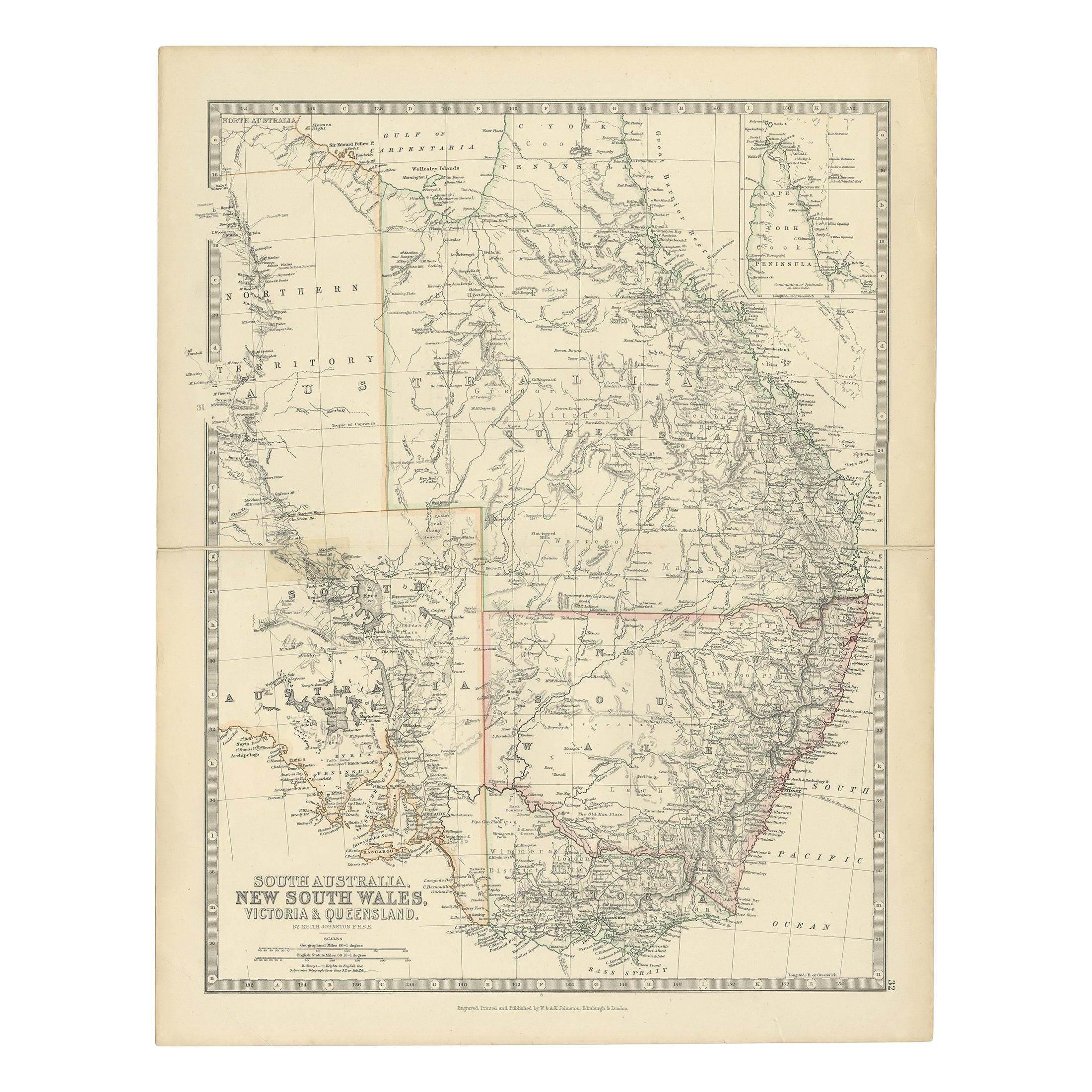
Antique Detailed Map of New South Wales, Queensland & Victoria, Australia, 1865
Located in Langweer, NL
Antique map Australia titled 'South Australia, New South Wales, Victoria & Queensland'. Old map depicting South Australia including New South Wal...
Category
Antique 19th Century Maps
Materials
Paper

$335 Sale Price
20% Off
Antique Map of Southeastern Australia by F. von Stülpnagel, 1850
Located in Langweer, NL
Antique map titled 'Süd-Östlichen Australien'. Map of southeastern Australia with inset maps of southwest Australia and Tasmania compiled by the military cartographer Friedrich von S...
Category
Antique Mid-19th Century Maps
Materials
Paper

$171 Sale Price
35% Off
Antique Map of South Australia, Victoria, Queensland and New South Wales, c.1860
Located in Langweer, NL
Antique map Australia titled 'South Australia, New South Wales, Victoria & Queensland'. Old map depicting South Australia including New South Wal...
Category
Antique 19th Century Maps
Materials
Paper

$325 Sale Price
20% Off
Antique Map of New South Wales 'Australia' by Wyld '1845'
Located in Langweer, NL
Antique map titled 'British Settlements in New South Wales'. Original antique map of New South Wales, Australia. This map originates from 'An Atlas of ...
Category
Antique Mid-19th Century Maps
Materials
Paper

$239 Sale Price
20% Off
You May Also Like
Original Antique Map of Tasmania, Australia by Dower, circa 1835
Located in St Annes, Lancashire
Nice map of Tasmania
Drawn and engraved by J.Dower
Published by Orr & Smith. C.1835
Unframed.
Free shipping
Category
Antique 1830s English Maps
Materials
Paper

Original Antique Map of Australia by Dower, circa 1835
Located in St Annes, Lancashire
Nice map of Australia
Drawn and engraved by J.Dower
Published by Orr & Smith. C.1835
Unframed.
Free shipping
Category
Antique 1830s English Maps
Materials
Paper

Australia, Tallis antique map, 1851
Located in Melbourne, Victoria
'Australia'
With decorative border surrounds and vignettes including a view of Sydney, Kangaroos, Natives of Australia Felix, Australian Parrots and Cockatoos and Natives of the Tri...
Category
19th Century Naturalistic Landscape Prints
Materials
Engraving

Large Original Antique Map of Australia by Sidney Hall, 1847
Located in St Annes, Lancashire
Great map of Australia
Drawn and engraved by Sidney Hall
Steel engraving
Original colour outline
Published by A & C Black. 1847
Unframed
Free shipping.
Category
Antique 1840s Scottish Maps
Materials
Paper

New South Wales, Australia, antique mid 19th century engraved John Tallis map
Located in Melbourne, Victoria
'New South Wales'
With decorative border surrounds and vignettes of 'Sydney Cove'. 'The Murray' and 'Xanthorrhea'.
'Drawn and engraved by J Rapkin'. Published by John Tallis.
375m...
Category
1840s Victorian Landscape Prints
Materials
Engraving

1851 Map of "Independent Tartary", Ric. R018
Located in Norton, MA
1851 Map of
Independent Tartary
"Russia"
Ric.r018
A highly decorative 1851 map of Independent Tartary by John Tallis and John Rapkin. Covers the regions between the Caspian Sea and Lake Bakquash and between Russia and Afghanistan. These include the ancient Silk Route kingdoms of Khiva, Tartaria, Kokand, and Bokhara. Today this region roughly includes Kazakhstan, Uzbekistan, Turkmenistan, Kyrgyzstan, and Tajikistan. This wonderful map offers a wealth of detail for anyone with an interest in the Central Asian portion of the ancient Silk Road. Identifies various caravan routes, deserts, wells, and stopping points, including the cities of Bokhara and Samarkand. Three vignettes by W. Bragg decorate the map, these including an image of Tartars on a Journey, a horseback Bride Chase, and a tartar camp site. Surrounded by a vine motif border. Engraved by J. Rapkin for John Tallis's 1851 Illustrated Atlas .
Tartary Antique Map...
Category
Antique 19th Century Unknown Maps
Materials
Paper

More Ways To Browse
British Empire
Victorian Antique Illustrations
Antique Oushak Carpets
Blue Coffee Tables
1945 Chair Juhl
Antique Three Leg Table
Folke Arstrom
Silver Over Copper
Vintage Barware Glasses
Antique Etched Glass
Antique French Shell
Coffee Table Black Italian Modern
Christofle America
Iranian Silk Rug Carpet
Poul Moller
Tables With Inlaid Wood
World War Table
Antonio Jacobsen