Items Similar to Old Map of Arabian Peninsula and Canaan, Highlighting Biblical Territories, 1750


Want more images or videos?
Request additional images or videos from the seller
1 of 10
Old Map of Arabian Peninsula and Canaan, Highlighting Biblical Territories, 1750
$680.78
£504.45
€570
CA$941.75
A$1,037.87
CHF 543.36
MX$12,748.38
NOK 6,827.46
SEK 6,389.96
DKK 4,340.97
About the Item
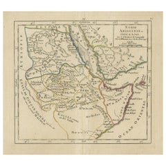
This antique map, titled "Terre de Chanaan ou Terre Promise a Abraham," is a finely detailed copper-engraved map created around 1750 by Delamarche in Paris, based on earlier works by Sanson and R. de Vaugondy. It prominently features the biblical land of Canaan, promised to Abraham, and is enhanced with hand-applied color highlighting regional boundaries.
The map integrates two significant insets: "Carte des Voiages d'Abraham" measuring 10.04 x 10.83 inches (25.5 x 27.5 cm), which traces the journeys of Abraham across the region, and "Disposition du Camp des Israelites," approximately 5.91 x 5.71 inches (15 x 14.5 cm), depicting the layout of the Israelites' camp. There is an illustration of the Ark of the Covenant in the lower-right corner. Measuring 16.73 x 21.85 inches (42.5 x 55.5 cm) in total, this historical piece exhibits some signs of aging with minor wear and occasional spotting, reflecting its rich history and antiquity. The central fold mark is typical of maps of this era, indicating it was likely housed in a bound atlas. This map is a captivating artifact, offering a glimpse into the geographical understanding and biblical interpretations of the mid-18th century.
The map is associated with the works of Robert de Vaugondy and Nicolas Sanson, two significant figures in the history of cartography, and was published by Charles François Delamarche, a notable French geographer and mapmaker from Paris.
Nicolas Sanson (1600-1667), often referred to as the "father of French cartography," was a pioneering figure in 17th-century French mapmaking. His work was highly influential and helped to establish a more scientific approach to mapmaking in France. Sanson's maps were known for their detailed accuracy and clear presentation, which helped to make them standard references in their time.
Robert de Vaugondy family, Gilles (1688-1766) and Didier (1723-1786), were prominent French cartographers in the 18th century who inherited the vast collection of map plates from the Sanson family. They revised and updated these maps to reflect new geographical knowledge and also produced their own original works. The Vaugondys were appointed as the official geographers to the French king, which underscores the significance and authority of their work in their era.
Charles François Delamarche (1740-1817) took over the Vaugondy publishing house in the late 18th century. He continued the tradition of producing high-quality maps and globes and was also known for innovating with educational products, including thematic and celestial maps. Delamarche's work represents a bridge between the meticulous detail of the Enlightenment and the growing public and educational interest in geographical knowledge during the French Revolution and Napoleonic eras.
Together, these figures represent a lineage of cartographic excellence, contributing to the evolution of mapmaking from a craft to a science, significantly influencing both the art and accuracy of maps used during their times. The map in question reflects this rich tradition and expertise, combining detailed cartographic information with historical and biblical references.
Antique maps of the region depicted in the map, which includes the Arabian Peninsula and the biblical lands often referred to as Canaan, appeal to collectors and enthusiasts for various historical and cultural reasons. Some of the main places and names that are popular in this context include:
1. Jerusalem - Often a central feature in maps of this area due to its profound historical and religious significance.
2. Mecca and Medina - These cities are of immense importance in Islamic tradition and history, making maps featuring them highly sought after.
3. The Red Sea - Often prominently featured in maps of the Arabian Peninsula, significant for its historical trade routes.
4. Sinai Peninsula - A key geographical and historical region connecting Africa and Asia, often noted in maps for its biblical significance, including Mount Sinai.
5. The Nile River - Maps featuring the Nile are popular due to the river's historical importance to civilizations in Egypt and its biblical associations.
6. Babylon - Located in modern-day Iraq, Babylon is of great historical and cultural interest, especially for its biblical connections.
7. Damascus - As one of the oldest continuously inhabited cities in the world, Damascus holds a special place in historical maps.
8. Petra - The ancient city of Petra, located in modern-day Jordan, is often featured due to its archaeological significance and its dramatic architecture.
The decorative elements, such as cartouches and illustrations depicting biblical scenes or historical figures, add to the desirability of these maps.
- Dimensions:Height: 21.86 in (55.5 cm)Width: 16.74 in (42.5 cm)Depth: 0 in (0.02 mm)
- Materials and Techniques:Paper,Engraved
- Place of Origin:
- Period:1750-1759
- Date of Manufacture:circa 1750
- Condition:Condition is fair. The map is worn and short on the margins. The borders are hand-colored. Folding line in middle as issued. All text and images still sharp. This map is showing a lot of patina. Please study the images carefully.
- Seller Location:Langweer, NL
- Reference Number:Seller: BG-138261stDibs: LU3054341112362
About the Seller
5.0
Recognized Seller
These prestigious sellers are industry leaders and represent the highest echelon for item quality and design.
Platinum Seller
Premium sellers with a 4.7+ rating and 24-hour response times
Established in 2009
1stDibs seller since 2017
2,618 sales on 1stDibs
Typical response time: <1 hour
- ShippingRetrieving quote...Shipping from: Langweer, Netherlands
- Return Policy
Authenticity Guarantee
In the unlikely event there’s an issue with an item’s authenticity, contact us within 1 year for a full refund. DetailsMoney-Back Guarantee
If your item is not as described, is damaged in transit, or does not arrive, contact us within 7 days for a full refund. Details24-Hour Cancellation
You have a 24-hour grace period in which to reconsider your purchase, with no questions asked.Vetted Professional Sellers
Our world-class sellers must adhere to strict standards for service and quality, maintaining the integrity of our listings.Price-Match Guarantee
If you find that a seller listed the same item for a lower price elsewhere, we’ll match it.Trusted Global Delivery
Our best-in-class carrier network provides specialized shipping options worldwide, including custom delivery.More From This Seller
View AllOld Map of the Arabian Peninsula with Parts of Egypt, Sudan, Eritrea & Ethiopia
Located in Langweer, NL
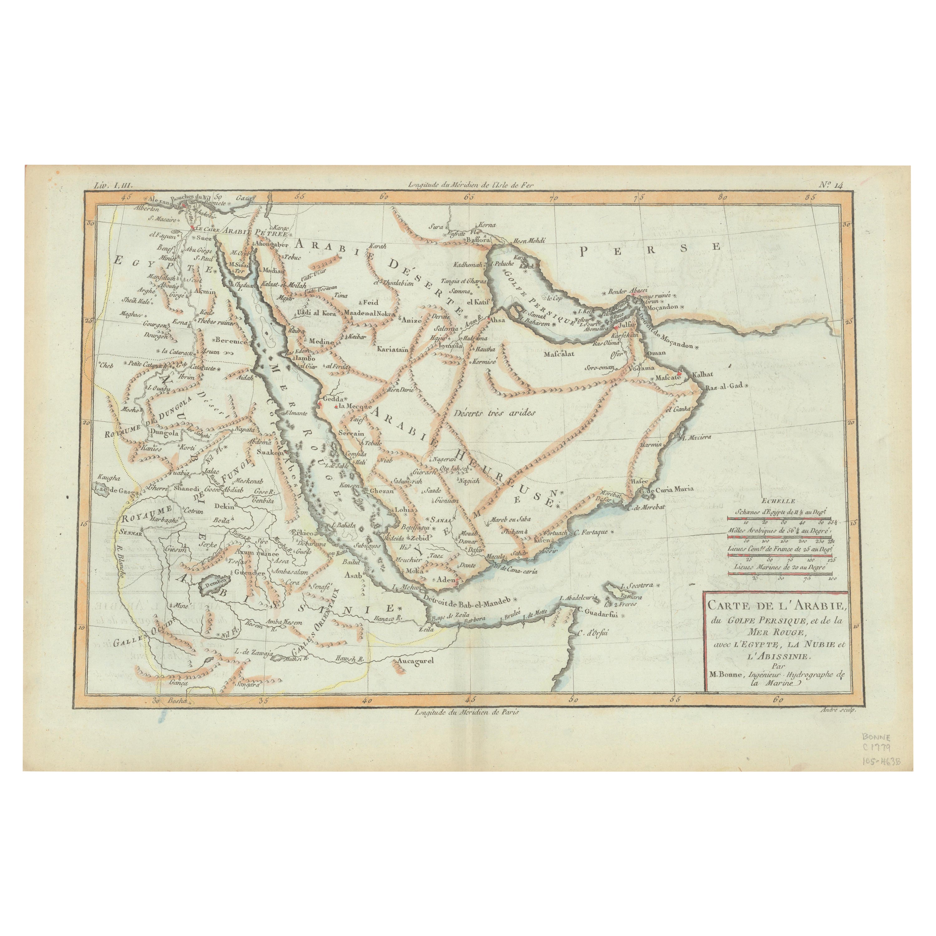
"Carte de l'Arabie, du Golfe Persique, et de la Mer Rouge, avec l'Egypte, la Nubie et l'Abissinie", Bonne, Rigobert
Subject: Arabia
Period: 1780 (circa)
Publication: Atlas de Toutes...
Category
Antique 1780s Maps
Materials
Paper
$363 Sale Price
20% Off
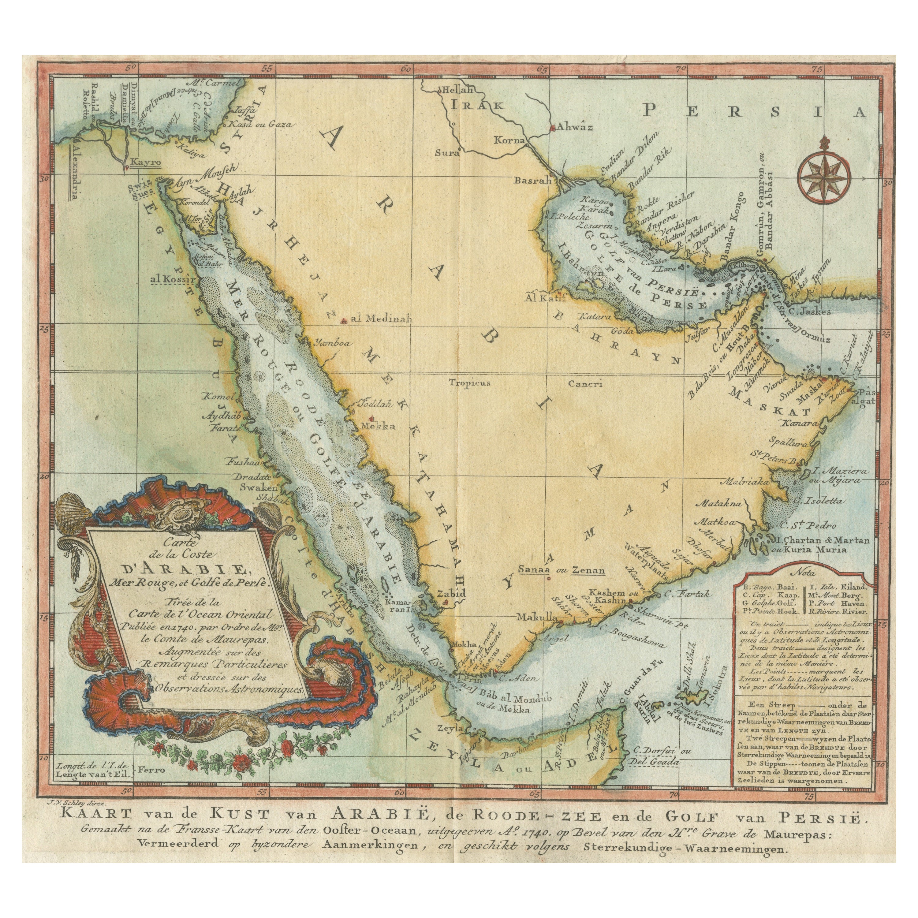
Original Antique Map of Arabia and the Red Sea, circa 1750
Located in Langweer, NL
Antique map titled 'Carte de la Coste d'Arabie (..) - Kaart van de Kust van Arabië (..)'. This is a Dutch version, engraved by J. van Schley, of Bellin's map of Arabia and the Red Sea...
Category
Antique Mid-18th Century Dutch Maps
Materials
Paper

$449 Sale Price
20% Off
Antique Map of the Arabian Peninsula by Franceschini, '1739'
Located in Langweer, NL
Antique map titled 'Conventus et Residentiae'. Rare map of the Arabian Peninsula. This map originates from 'Provinciarum et Conventum Fratrum Discalc...
Category
Antique Mid-18th Century Maps
Materials
Paper

$537 Sale Price
40% Off
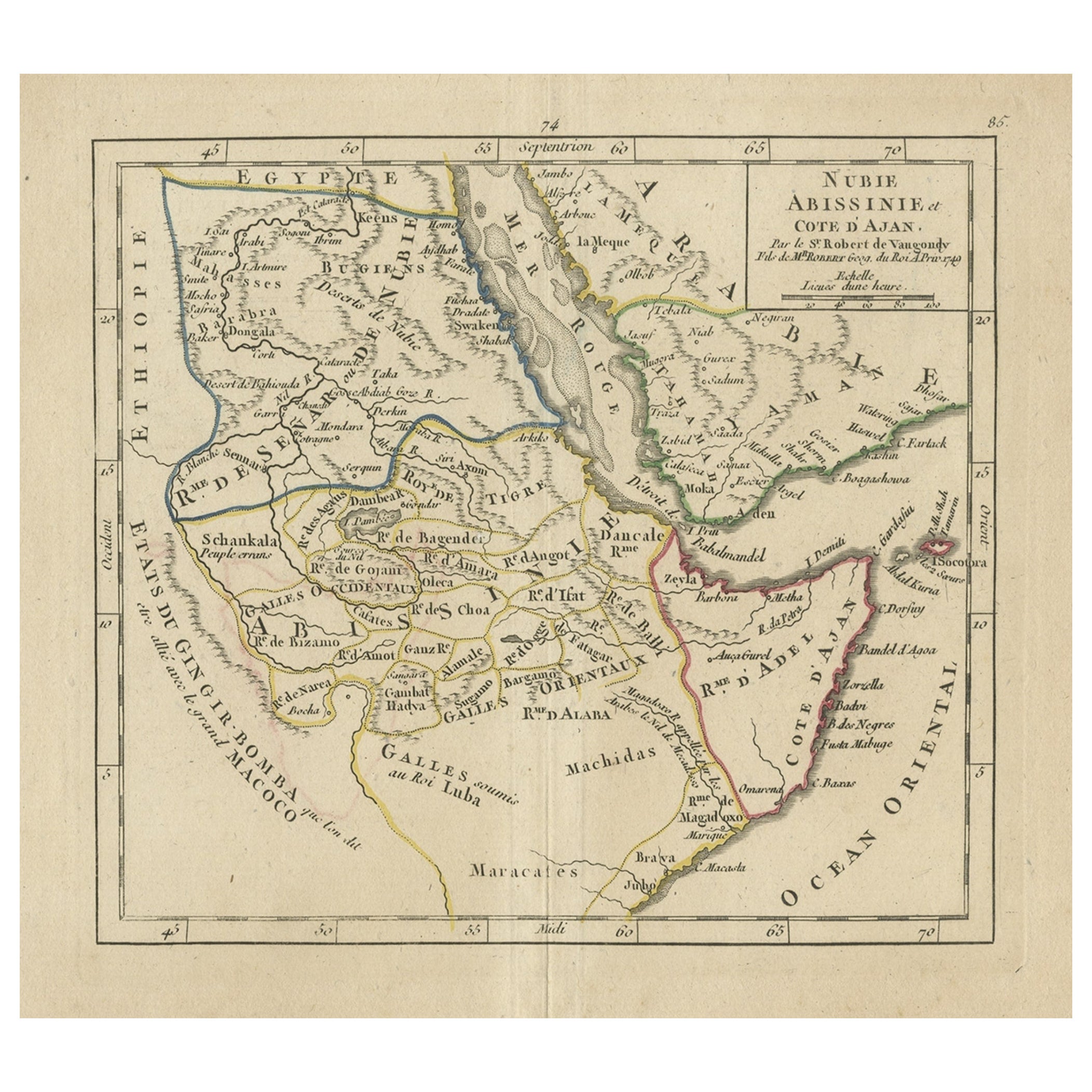
Original Antique Map of Abyssinia, Sudan and the Red Sea, 1749
Located in Langweer, NL
Antique map titled 'Nubie, Abissinie et Cote d'Ajan'.
Map of Abyssinia, Sudan and the Red Sea by Robert Vaugondy. Covers from Arabia and Egypt south to M...
Category
Antique 1740s Maps
Materials
Paper
$324 Sale Price
20% Off
Antique Map of the Arabian Peninsula by Bellin 'c.1740'
Located in Langweer, NL
Antique map titled 'Carte de la Coste d'Arabie, Mer Rouge et Golfe de Perse'. Original antique map of the Arabian Peninsula, labes both Mecca and Med...
Category
Antique Mid-18th Century Maps
Materials
Paper

$477 Sale Price
20% Off
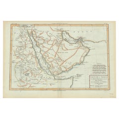
Antique Map of the Arabian Peninsula by Bonne 'c.1780'
Located in Langweer, NL
Antique map titled 'Carte de l'Arabie, du Golfe Persique, et de la Mer Rouge (..)'. Original antique map of the Arabian Peninsula, including the horn...
Category
Antique Late 18th Century Maps
Materials
Paper

$477 Sale Price
20% Off
You May Also Like
Antique French Map of Asia Including China Indoneseia India, 1783
Located in Amsterdam, Noord Holland
Very nice map of Asia. 1783 Dedie au Roy.
Additional information:
Country of Manufacturing: Europe
Period: 18th century Qing (1661 - 1912)
Condition: Overall Condition B (Good Used)...
Category
Antique 18th Century European Maps
Materials
Paper

$648 Sale Price
20% Off
Antique 1803 Italian Map of Asia Including China Indoneseia India
Located in Amsterdam, Noord Holland
Antique 1803 Italian Map of Asia Including China Indoneseia India
Very nice map of Asia. 1803.
Additional information:
Type: Map
Country of Manufacturing: Europe
Period: 19th centu...
Category
Antique 19th Century European Maps
Materials
Paper

$584 Sale Price
20% Off
Map Holy Land La Terre Sainte Engraved van Loon Published N de Fer 1703 French
Located in BUNGAY, SUFFOLK
La Terre Sainte, The Holy Land, Tiree Des Memoires De M.De.La Rue. Par N. de Fer. Geographe de Sa Majeste Catoliq et de Monseigneur le Dauphin. Avec Privil du Roi 1703
Detailed map of the Holy Land from Nicholas de Fer's L'Atlas Curieux ou le Monde. East is oriented at the top.
MAKER Nicolas de Fer 1646-1720
The French cartographer and engraver, Nicolas de Fer, was a master at creating maps that were works of art. The maps that he published were printed during the Baroque period when the decorative arts were characterized by ornate detail. De Fer’s detailed maps and atlases were valued more for their decorative content than their geographical accuracy.
Nicolas de Fer was born in 1646. His father, Antoine de Fer, owned a mapmaking firm. At the age of twelve, Nicolas was apprenticed to a Parisian engraver named Louis Spirinx. The family business was starting to decline when his father died in 1673. Nicolas de Fer’s mother, Genevieve, took over the business after the death of her husband. In 1687 the business was passed on to Nicolas and the profits increased after he took over the firm. Nicolas de Fer was a prolific cartographer who produced atlases and hundreds of single maps. He eventually became the official geographer to King Louis XIV of France and King Philip V...
Category
Antique Early 1700s French Louis XIV Maps
Materials
Paper

Original Antique Map of Ancient Greece- Boeotia, Thebes, 1787
Located in St Annes, Lancashire
Great map of Ancient Greece. Showing the region of Boeotia, including Thebes
Drawn by J.D. Barbie Du Bocage
Copper plate engraving by P.F T...
Category
Antique 1780s French Other Maps
Materials
Paper

Map of the Holy Land "Carte de la Syrie et de l'Egypte" by Pierre Lapie
By Pierre M. Lapie
Located in Alamo, CA
This is an early 19th century map of ancient Syria and Egypt entitled "Carte de la Syrie et de l'Egypte anciennes/dressée par M. Lapie, Colonel d'Etat M...
Category
1830s Landscape Prints
Materials
Engraving

Map of the Kingdom of Sardinia and Part of the Kingdom of Genoa, Rome
By Giovanni Maria Cassini
Located in Hamilton, Ontario
18th century map by Italian engraver Giovanni Maria Cassini (Italy 1745-1824). Map of Part of the Kingdom of Sardinia and Part of the Kingdom of Genoa: Rome. This is a hand colored a...
Category
Antique 18th Century Italian Maps
Materials
Paper

$795 Sale Price
36% Off
More Ways To Browse
Arabian Antique
King Of Egypt
Antique Ark
3 D Asian Paper Art
Orange Coffee Table
Round Brass Table
Set Of Four Italian Dining Chairs
Black And Chrome Lounge Chair
Pedestal Mahogany Dining Table
Round Table Base
Metal Coffee Table 1970s
Wash Stand
18th Century Blue And White Porcelain
Antique Imari Porcelain
Antique Pagoda
Belgian Antiques
Italian Lacquer Dining Room Sets
Paisley Rugs and Carpets