Items Similar to Old Map of the Overland Route to California – Early Exploration Pathways, 1701

Want more images or videos?
Request additional images or videos from the seller
1 of 10
Old Map of the Overland Route to California – Early Exploration Pathways, 1701
$584.94
£430.95
€490
CA$805.07
A$893.35
CHF 471.22
MX$10,905.88
NOK 5,961.85
SEK 5,583.75
DKK 3,729.91
About the Item
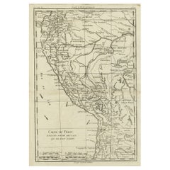
Map of the Overland Route to California – 18th Century
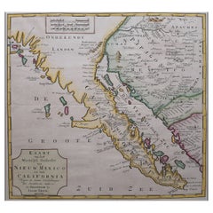
This 18th-century copperplate map, titled Passage par terre à la Californie, illustrates the overland route to California as recorded by the Jesuit missionary Father Eusebio Francisco Kino (P. Kino Soc. Jesu). Kino’s explorations in the late 17th and early 18th centuries were pivotal in correcting the prevailing European misconception that California was an island.
The map covers the northwestern region of New Spain, including the Baja California peninsula (Mer de la Californie), the Gulf of California (Mer de la Californie or Mer Vermeille), Sonora, and parts of present-day Arizona and New Mexico (Nouveau Mexique). Indigenous groups such as the Yumas, Hoabomonas, Cocomaricopas, Moquis (Hopi), Apaches, and others are noted, alongside mission settlements, presidios, and key geographic features.
The coastal areas are dotted with bays, ports, and islands, including the Isles de l’Angel de la Guardia, Carmen, and Tiburon. Inland, the map identifies rivers, mountain ranges (including the “Grande montagne qui sépare Sonora de la Moqui”), and routes used during Kino’s expeditions.
An important historical feature of this map is its role in demonstrating California’s connection to the mainland, contradicting earlier European maps that depicted it as insular. Kino’s work, based on extensive travel and interaction with indigenous communities, provided some of the most accurate cartographic information on the region available to Europeans at the time.
Marked “Tome 4, N° 8” in the upper right, the engraving is part of a larger Enlightenment-era travel and exploration series. Its style combines scientific geographic recording with an ethnographic interest in indigenous peoples and colonial missionary efforts.
Condition: Very good for age, with a central fold as issued. Minor toning and slight foxing at the margins. Strong plate impression with sharp detail in both coastal and inland features.
Framing tips: A dark walnut or black frame with a cream mount will emphasize the crisp engraving and historical interest. This map pairs well with other 18th-century maps of the Americas, especially those linked to exploration and missionary history.
Technique: Copperplate engraving
Maker: Based on the explorations of Eusebio Francisco Kino, French school, c.1760
- Dimensions:Height: 11.03 in (28 cm)Width: 9.45 in (24 cm)Depth: 0.01 in (0.2 mm)
- Materials and Techniques:Paper,Engraved
- Place of Origin:
- Period:
- Date of Manufacture:circa 1701
- Condition:Condition: Very good for age, with a central fold as issued. Minor toning and slight foxing at the margins. Strong plate impression with sharp detail in both coastal and inland features.
- Seller Location:Langweer, NL
- Reference Number:Seller: BG-14078-331stDibs: LU3054346218312
About the Seller
5.0
Recognized Seller
These prestigious sellers are industry leaders and represent the highest echelon for item quality and design.
Platinum Seller
Premium sellers with a 4.7+ rating and 24-hour response times
Established in 2009
1stDibs seller since 2017
2,569 sales on 1stDibs
Typical response time: <1 hour
- ShippingRetrieving quote...Shipping from: Langweer, Netherlands
- Return Policy
Authenticity Guarantee
In the unlikely event there’s an issue with an item’s authenticity, contact us within 1 year for a full refund. DetailsMoney-Back Guarantee
If your item is not as described, is damaged in transit, or does not arrive, contact us within 7 days for a full refund. Details24-Hour Cancellation
You have a 24-hour grace period in which to reconsider your purchase, with no questions asked.Vetted Professional Sellers
Our world-class sellers must adhere to strict standards for service and quality, maintaining the integrity of our listings.Price-Match Guarantee
If you find that a seller listed the same item for a lower price elsewhere, we’ll match it.Trusted Global Delivery
Our best-in-class carrier network provides specialized shipping options worldwide, including custom delivery.More From This Seller
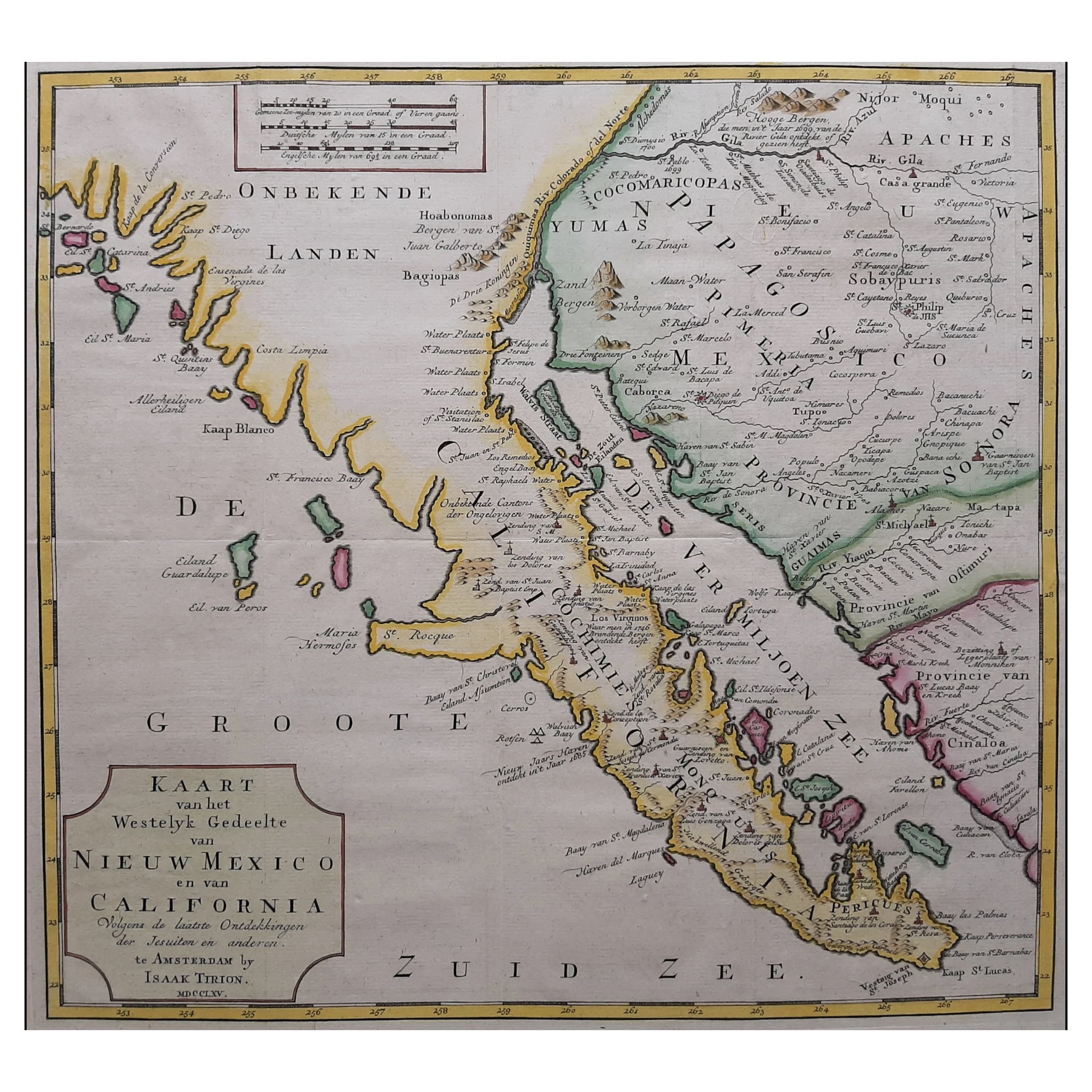
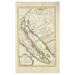
View AllOriginal Antique Map of the Western Part of NEW MEXICO & CALIFORNIA
Located in Langweer, NL
Title: "Map of the Western Part of NEW MEXICO and CALIFORNIA According to the Latest Discoveries by the Jesuits and Others"
Description:
This exquisite original Dutch map, titled "...
Category
Antique 1760s Maps
Materials
Paper
$1,241 Sale Price
20% Off
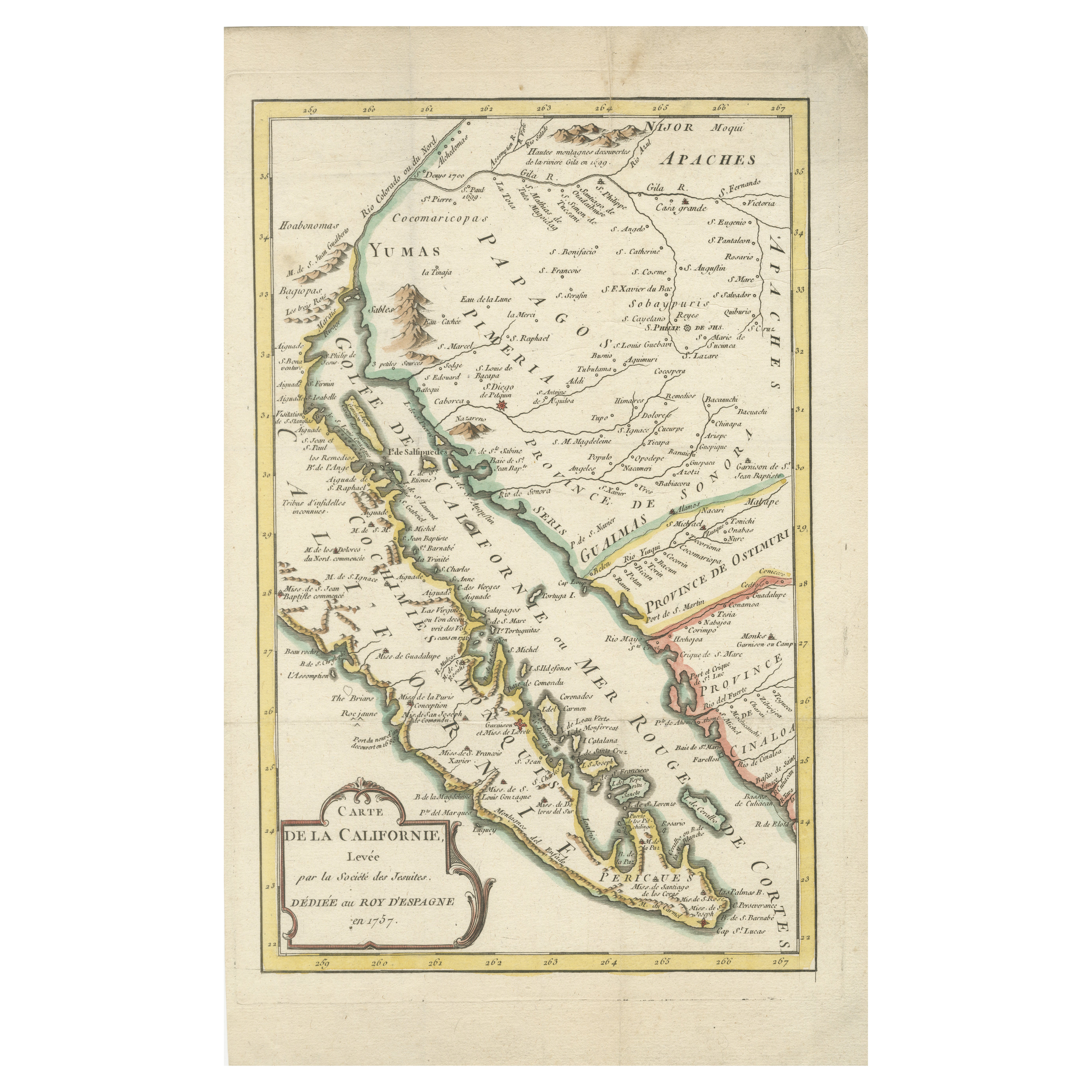
Rare 1757 Jesuit Map of California and Baja, Dedicated to the King of Spain
Located in Langweer, NL
Title: Rare 1757 Jesuit Map of California and Baja, Dedicated to the King of Spain
This rare and detailed map, titled *Carte de la Californie Levee par la Société des Jésuites*, wa...
Category
Antique 1750s Maps
Materials
Paper
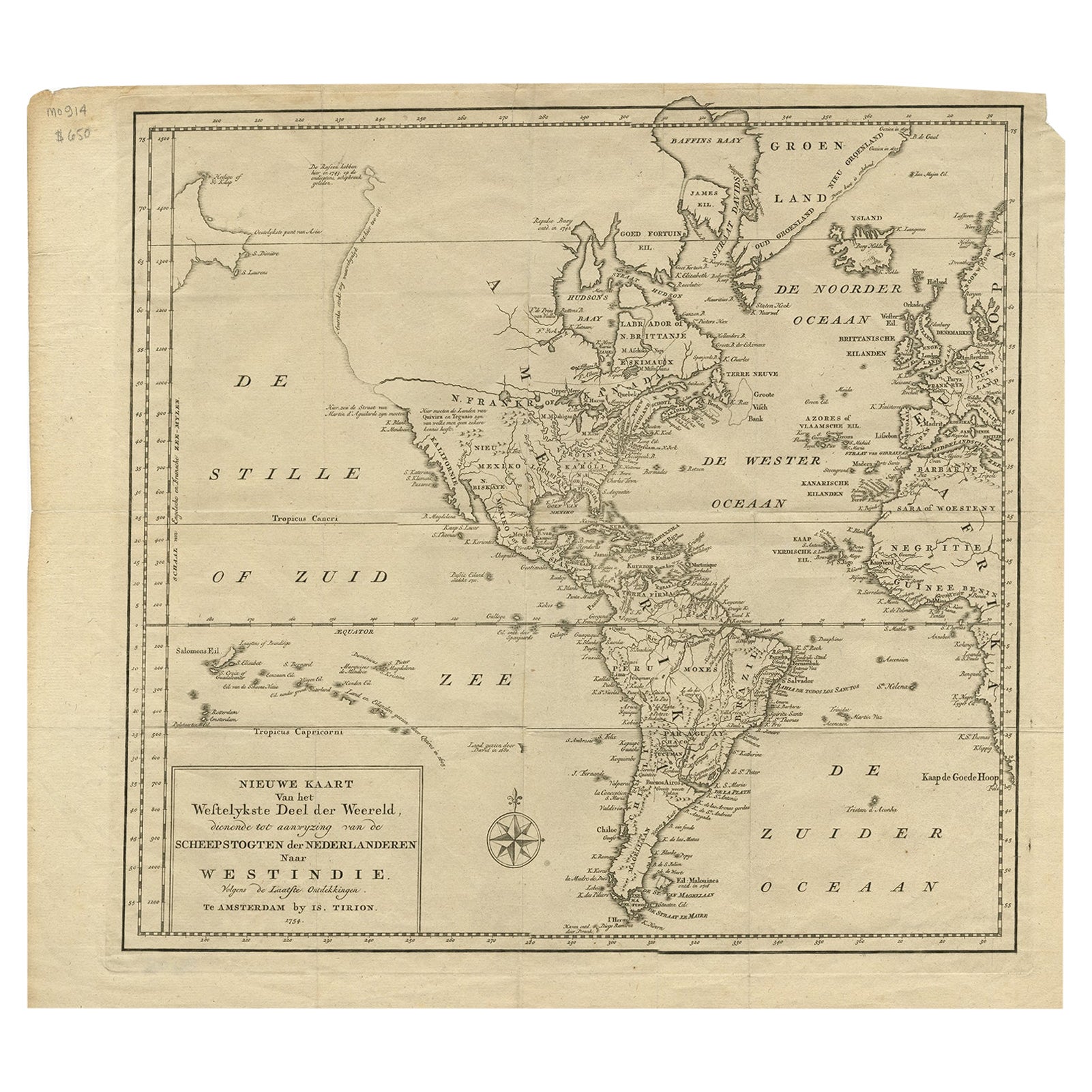
Excellent Antique Map of America with Unusual Northwest Coast of America, c.1754
Located in Langweer, NL
Description: Antique map titled 'Nieuwe Kaart Van het Westelykste Deel Der Weereld, dienende tot aanwyzing an de Scheepstogten der Nederlanderne Naar West Indie.' Excellent map of America, featuring an unusual northwest coast of America, which includes Martin d'Aguilar's strait which provides for a Northwest Passage via the Great Lakes. The rest of the NW coast...
Category
Antique 1750s Maps
Materials
Paper
$549 Sale Price
20% Off
Antique Map of America with California as an Island by Homann '1710'
Located in Langweer, NL
This antique map, titled "Totius Americae Septentrionalis et Meridionalis," represents a significant cartographic piece from 1710 by Johann Baptist Homann. Here's a description of this remarkable map:
- Title: Totius Americae Septentrionalis et Meridionalis (...)
- Date: Published in 1710 by Johann Baptist Homann.
Description:
This map is a first edition of Johann Baptiste Homann's map of America, and it is notable for several cartographic features and historical representations:
1. California as an Island...
Category
Antique Early 18th Century Maps
Materials
Paper

$2,234 Sale Price
25% Off
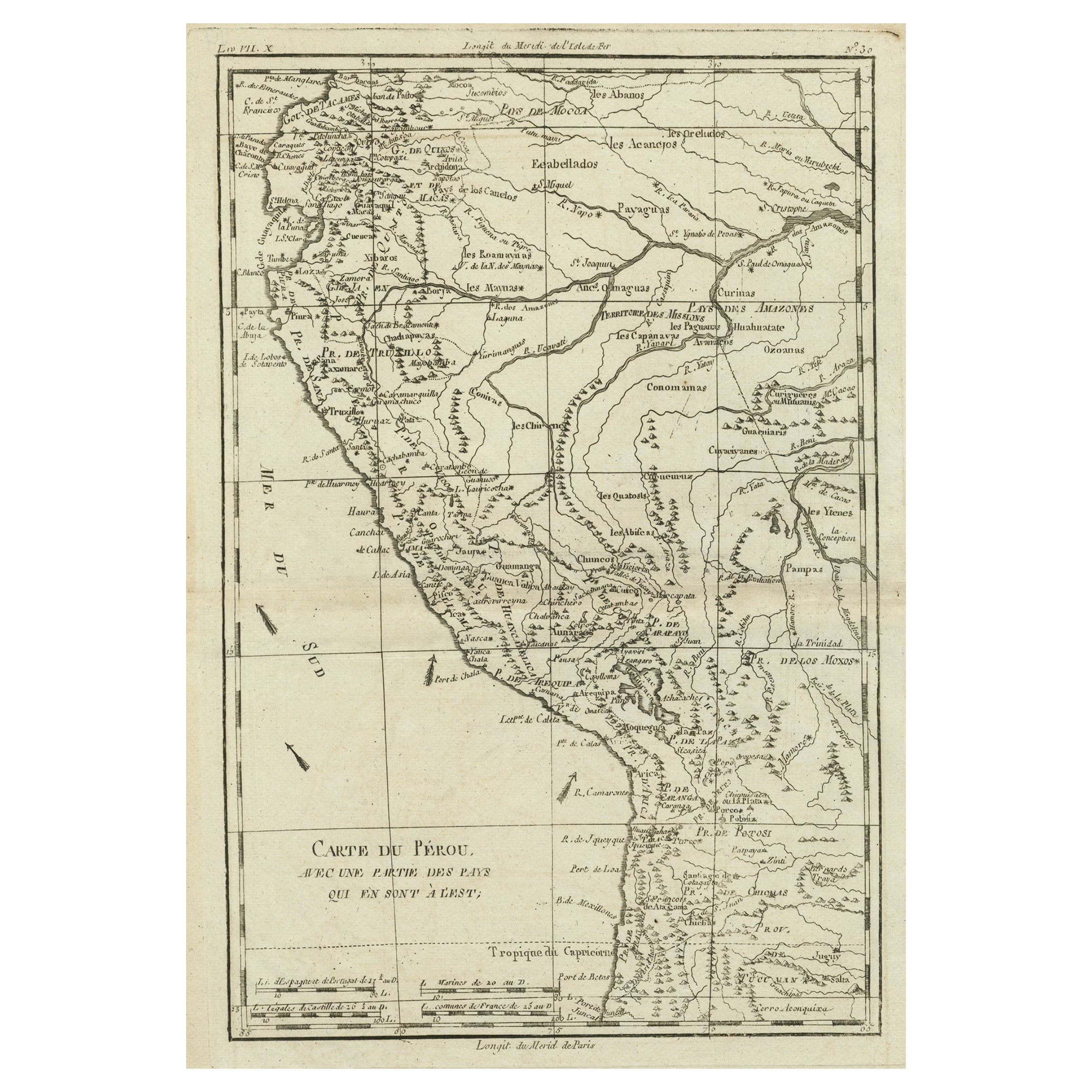
Map of the Western Coast of South America from Ecuador into Chili, ca.1780
Located in Langweer, NL
Antique map titled 'Carte du Perou avec une partie des pays qui en sont a l'est.'
Map of the western coast of South America extending from Ecuador, through Peru and present-day B...
Category
Antique 1780s Maps
Materials
Paper
$324 Sale Price
20% Off
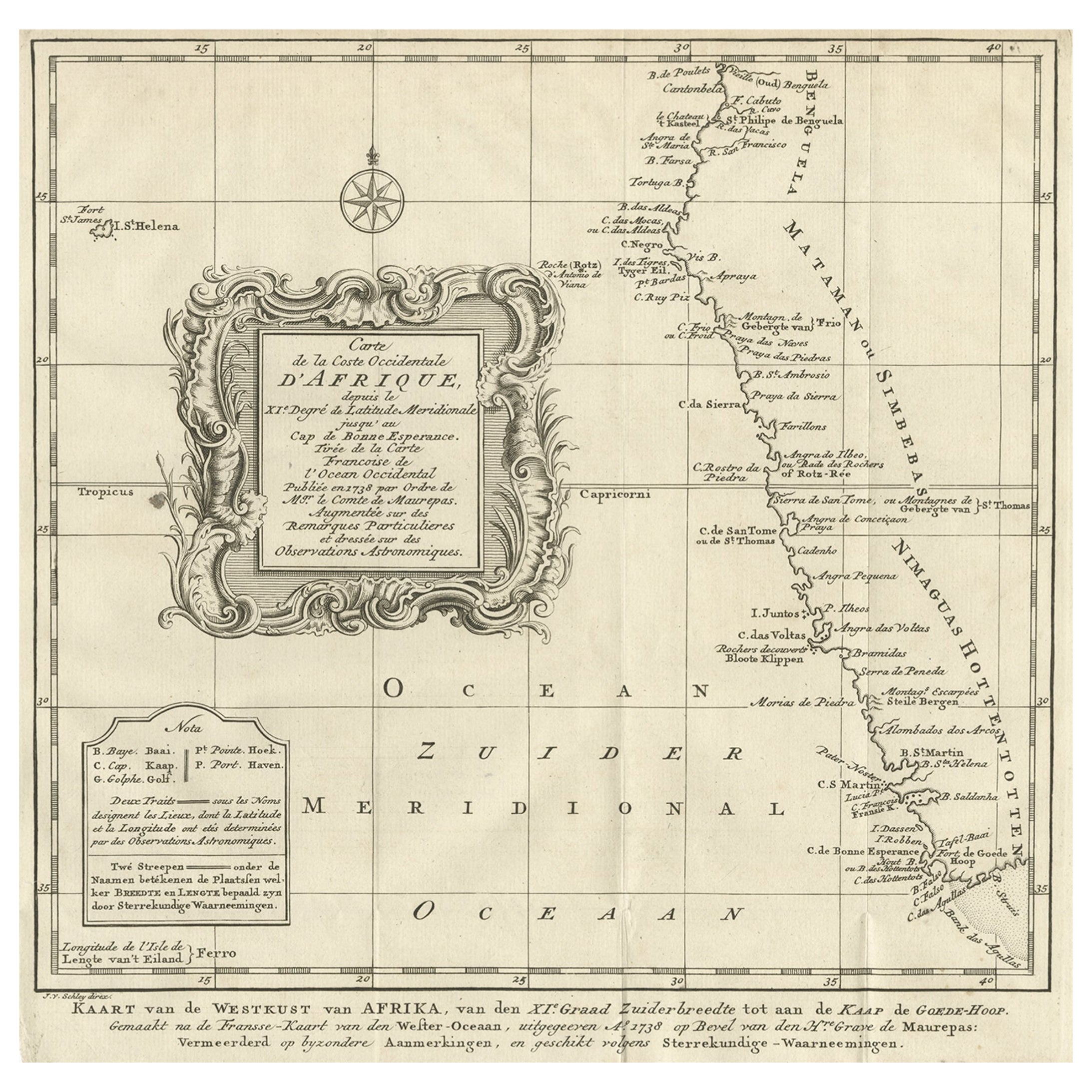
Dutch Antique Map of the West Coast of Africa, to the Cape of Good Hope, 1747
Located in Langweer, NL
Antique map of the Coast of Africa titled 'Kaart van de West Kust van Afrika (..)'.
Map of the west coast of Africa, from 11 degrees south latitude to the Cape of Good Hope. This...
Category
Antique 1740s Maps
Materials
Paper
$371 Sale Price
20% Off
Free Shipping
You May Also Like
Antique Map of California as an Island "The 5 Californias" by Robert de Vaugondy
Located in San Diego, CA
A very nice and rare antique map entitled "Carte de la Californie Suivant" (The 5 Californias), by Didier Robert de Vaugondy of Paris, circa 1772. The map itself measures 15.5" x 13...
Category
Antique Mid-19th Century American Maps
Materials
Paper

Original Antique Map of North America by Dower, circa 1835
Located in St Annes, Lancashire
Nice map of North America
Drawn and engraved by J.Dower
Published by Orr & Smith. C.1835
Unframed.
Free shipping
Category
Antique 1830s English Maps
Materials
Paper

California: 18th Century Hand-colored Map by de Vaugondy
By Didier Robert de Vaugondy
Located in Alamo, CA
This is an 18th century hand-colored map of the western portions of North America entitled "Carte de la Californie et des Pays Nord-Ouest separés de l'Asie par le détroit d'Anian, ex...
Category
1770s Landscape Prints
Materials
Engraving

Ancient Map of Mexico - Original Etching - 19th Century
Located in Roma, IT
This Map of Mexico is an etching realized in 19th century.
The state of preservation of the artwork is good with some small missing papers on the right angles. At the top of the pap...
Category
19th Century More Prints
Materials
Etching
Original Antique Map of Central America / Florida, Arrowsmith, 1820
Located in St Annes, Lancashire
Great map of Central America.
Drawn under the direction of Arrowsmith.
Copper-plate engraving.
Published by Longman, Hurst, Rees, Orme and Brown, 1820
Unframed.
Category
Antique 1820s English Maps
Materials
Paper

Antique Map - Mare Pacificum - Etching by Johannes Janssonius - 1650s
By Johannes Janssonius
Located in Roma, IT
Mare Pacificum is an antique map realized in 1650 by Johannes Janssonius (1588-1664).
The Map is Hand-colored etching, with coeval watercolorang.
Good conditions with slight foxing...
Category
1650s Modern Figurative Prints
Materials
Etching
