Items Similar to Original Antique Map of Palencia Province, in Northern Spain, 1901


Want more images or videos?
Request additional images or videos from the seller
1 of 6
Original Antique Map of Palencia Province, in Northern Spain, 1901
$367.94
$459.9320% Off
£275.42
£344.2720% Off
€312
€39020% Off
CA$506.40
CA$632.9920% Off
A$564.43
A$705.5420% Off
CHF 296.14
CHF 370.1720% Off
MX$6,892.62
MX$8,615.7820% Off
NOK 3,749.75
NOK 4,687.1820% Off
SEK 3,544.08
SEK 4,430.1020% Off
DKK 2,375.16
DKK 2,968.9520% Off
About the Item
This historical map is of Palencia, a province in the northern part of Spain.
Palencia is situated within the autonomous community of Castilla y León. It is bordered by the provinces of León, Cantabria, Burgos, and Valladolid. The capital city is also called Palencia. It is known for its historical heritage, including the Gothic Cathedral (Palencia Cathedral), which is one of the largest in Europe. The province features a varied landscape with the fertile Tierra de Campos on the plains used primarily for agriculture, and to the north, the Cantabrian Mountains with the protected natural spaces.
Agriculture has traditionally been the mainstay of the province's economy, with crops such as wheat, barley, and sugar beets being prominent.
The Romanesque architecture is significant in Palencia, with the area along the Camino de Santiago pilgrimage route, especially the town of Carrión de los Condes, featuring notable churches and monasteries.
Palencia has natural reserves such as Fuentes Carrionas y Fuente Cobre-Montaña Palentina Natural Park, which provides a habitat for a variety of wildlife and is a destination for outdoor activities.
Palencia has several historical sites dating back to the Roman era and played a significant role during the Reconquista and in the later Middle Ages.
This province, like many others in Spain, is steeped in history and rich in cultural and natural attractions.
The province of Palencia is located in the northern part of Spain, within the autonomous community of Castile and León. It is characterized by a diverse landscape that includes part of the Cantabrian Mountains to the north and the expansive Castilian Plateau (Meseta Castellana) to the south. The province is home to a rich historical heritage, with numerous Romanesque churches, particularly in the city of Palencia, which is the capital and a significant urban center. The province is also known for its natural beauty, including the Natural Park of Fuentes Carrionas and Fuente Cobre-Montaña Palentina to the north.
- Dimensions:Height: 14.77 in (37.5 cm)Width: 20.08 in (51 cm)Depth: 0 in (0.02 mm)
- Materials and Techniques:
- Period:1900-1909
- Date of Manufacture:1901
- Condition:Good condition. Central vertical folding lines as issued. Aged paper with typically warm, yellowish-brown hue, especially around the edges. A light brown discoloring along the top of the fold. Check the images carefully.
- Seller Location:Langweer, NL
- Reference Number:Seller: BG-13642-331stDibs: LU3054338032442
About the Seller
5.0
Recognized Seller
These prestigious sellers are industry leaders and represent the highest echelon for item quality and design.
Platinum Seller
Premium sellers with a 4.7+ rating and 24-hour response times
Established in 2009
1stDibs seller since 2017
2,517 sales on 1stDibs
Typical response time: <1 hour
- ShippingRetrieving quote...Shipping from: Langweer, Netherlands
- Return Policy
Authenticity Guarantee
In the unlikely event there’s an issue with an item’s authenticity, contact us within 1 year for a full refund. DetailsMoney-Back Guarantee
If your item is not as described, is damaged in transit, or does not arrive, contact us within 7 days for a full refund. Details24-Hour Cancellation
You have a 24-hour grace period in which to reconsider your purchase, with no questions asked.Vetted Professional Sellers
Our world-class sellers must adhere to strict standards for service and quality, maintaining the integrity of our listings.Price-Match Guarantee
If you find that a seller listed the same item for a lower price elsewhere, we’ll match it.Trusted Global Delivery
Our best-in-class carrier network provides specialized shipping options worldwide, including custom delivery.More From This Seller
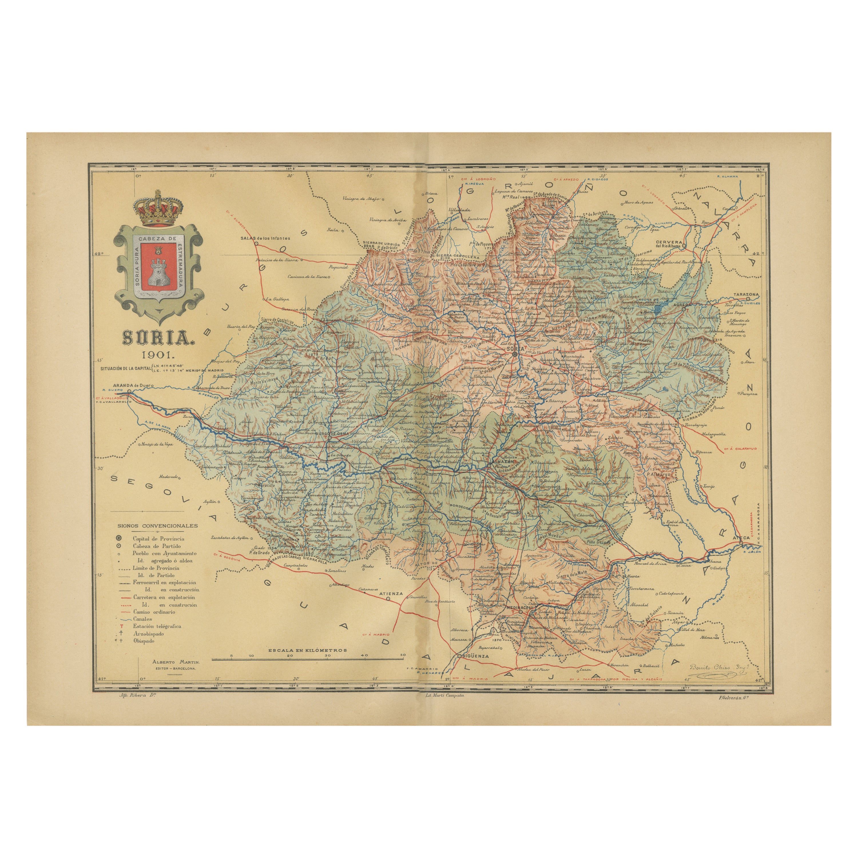
View AllMap of Soria Province, 1901: Detailed Cartography of Northeastern Spain
Located in Langweer, NL
The map is a historical map of the province of Soria from 1901.
A decorative coat of arms enhances the aesthetic of the map, signifying the historical and cultural significance of ...
Category
Antique Early 1900s Maps
Materials
Paper

$311 Sale Price
20% Off
Free Shipping
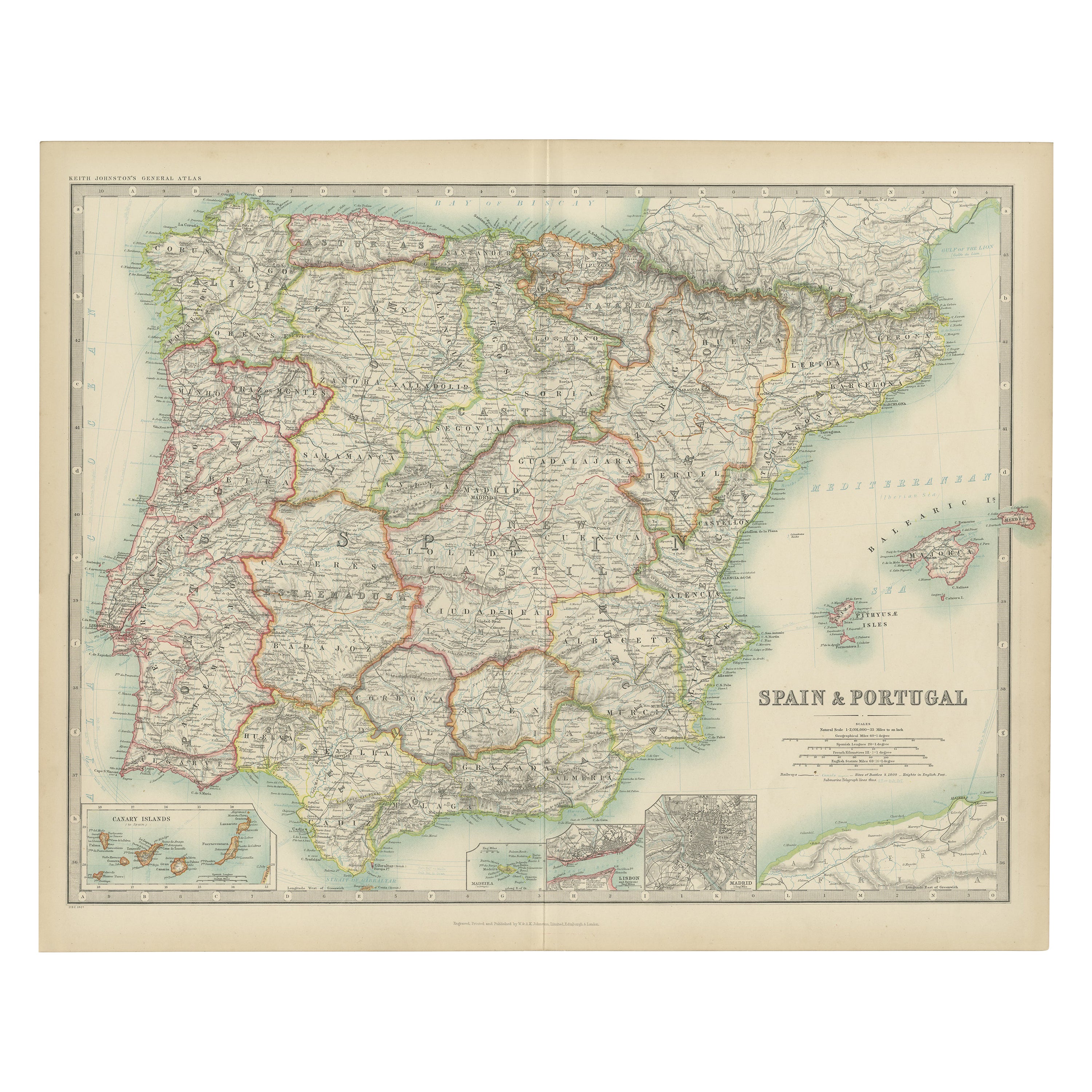
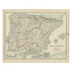
Antique Map of Spain and Portugal by Johnston, '1909'
Located in Langweer, NL
Antique map titled 'Spain and Portugal'. Original antique map of Spain and Portugal. With inset maps of the Canary Islands, Madeira, Lisbon and Ma...
Category
Early 20th Century Maps
Materials
Paper
$235 Sale Price
20% Off
Topographical and Infrastructure Map of the Province of Valencia, 1901
Located in Langweer, NL
A historical map of the province of Valencia, dated 1901. The map includes intricate details such as topographical features, with mountain ranges and river systems prominently marked...
Category
Antique Early 1900s Maps
Materials
Paper

$490 Sale Price
20% Off
Free Shipping
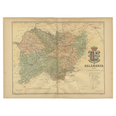
1902 Cartographic View of Salamanca: The Golden Province of Spain
Located in Langweer, NL
This map showcases the province of Salamanca in the year 1902. Salamanca is located in the autonomous community of Castile and León in western Spain. It is bordered by the provinces ...
Category
Antique Early 1900s Maps
Materials
Paper
$260 Sale Price
35% Off
Free Shipping
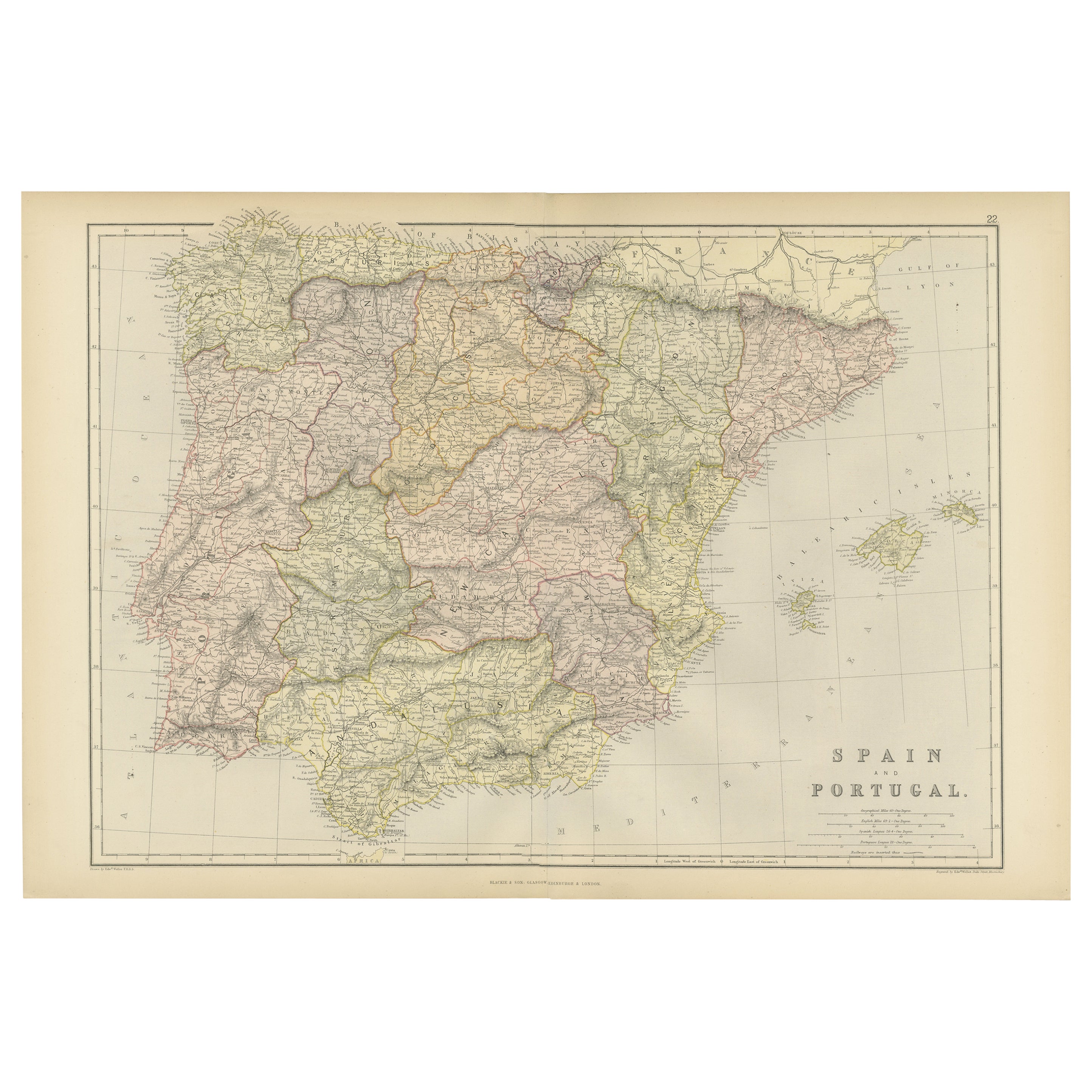
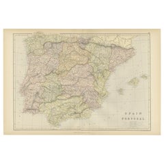
Original Antique Map of Spain and Portugal, 1882
Located in Langweer, NL
Embark on a historical voyage with an original Antique Map of Spain and Portugal from the esteemed 'Comprehensive Atlas and Geography of the World,' meticulously crafted in 1882. Thi...
Category
Antique 1880s Maps
Materials
Paper
$160 Sale Price
20% Off
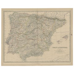
Antique Map of Spain and Portugal, 1882
Located in Langweer, NL
"Antique map titled 'Spain & Portugal'.
Old map of Spain and Portugal. This map originates from 'The Royal Atlas of Modern Geography, Exhibiting, in a S...
Category
Antique 19th Century Maps
Materials
Paper
$216 Sale Price
20% Off
You May Also Like
Large Original Vintage Map of Spain, circa 1920
Located in St Annes, Lancashire
Great map of Spain
Original color.
Good condition
Published by Alexander Gross
Unframed.
Category
Vintage 1920s English Maps
Materials
Paper

Original Antique Map of Spain and Portugal, circa 1790
Located in St Annes, Lancashire
Super map of Spain and Portugal
Copper plate engraving by A. Bell
Published, circa 1790.
Unframed.
Category
Antique 1790s English Other Maps
Materials
Paper

Large Original Antique Map of The South of Italy. John Dower, 1861
Located in St Annes, Lancashire
Great map of the South of Italy
Lithograph engraving by John Dower
Original colour
Published, 1861
Unframed
Good condition
Free shipping
Category
Antique 1860s English Victorian Maps
Materials
Paper

Italy, Northern Part. Century Atlas antique vintage map
Located in Melbourne, Victoria
'The Century Atlas. Italy, Northern Part.'
Original antique map, 1903.
Central fold as issued. Map name and number printed on the reverse corners.
Sheet 29.5cm by 40cm.
Category
Early 20th Century Victorian More Prints
Materials
Lithograph

Map of Spain and Portugal - Original Etching - Late 19th Century
Located in Roma, IT
This Map of Spain and Portugal is an etching realized by an anonymous artist.
The state of preservation of the artwork is good with some small diffused stains.
Sheet dimension: 28...
Category
Late 19th Century Modern Figurative Prints
Materials
Etching

Italy, Central and Southern Part. Century Atlas antique map
Located in Melbourne, Victoria
'The Century Atlas. Italy, Central and Southern Part.'
Original antique map, 1903.
Inset maps of Sicily and Naples.
Central fold as issued. Map name an...
Category
Early 20th Century Victorian More Prints
Materials
Lithograph

More Ways To Browse
Gothic Cathedral
Castilian Furniture
Antique Oushak
Mid Century Danish Directors Chairs
Moller 70
Argentina Travel Poster
Century Furniture Faux Bamboo
Early American Chairs
Hans Muller
Vintage Wood Table With Glass Top
19th Century Square Table
Antonio Bonet
Galle Chairs
Large Chinese Rug
1940s Vintage French Art Deco
20th Century Spanish Table
Antonio Bellini
Retro Fiberglass Furniture