Items Similar to Original Antique Map of West Central France in Frame, 1748

Want more images or videos?
Request additional images or videos from the seller
1 of 6
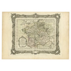
Original Antique Map of West Central France in Frame, 1748
$274.10
$342.6220% Off
£205.45
£256.8220% Off
€232
€29020% Off
CA$376.56
CA$470.7020% Off
A$420.40
A$525.5020% Off
CHF 220.28
CHF 275.3520% Off
MX$5,146.07
MX$6,432.5920% Off
NOK 2,797.58
NOK 3,496.9720% Off
SEK 2,637.76
SEK 3,297.2020% Off
DKK 1,766.07
DKK 2,207.5920% Off
About the Item
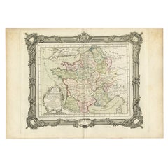
A nicely framed and hand-coloured decorative map titled "Gouvernemens Generaux De Poitou et De Saintonge" and engraved by M. Robert. This historical international map includes several specific locations, such as the Isle Dieu, Bretagne, Anjou, Touraine, Angoumois, Perigold, Saintonge, Mer de Gascogne (Bay of Biscay), Poitou, Aunis, Guienne, la Garonne Riviere (Garonne River), and Loudunois, as well as the Tour de Cordouan (Cordouan Lighthouse).
Featured towns on this map include Tonnay, Talmont, Loudun, Mortemer, Poitiers, Chalais, Riberac, Angoule, Marton, Blaye, and Monbrun.
This antique map represents the west-central region of France.
The theme of the atlas from which this map originates is the "Atlas Portatif Universel Et Militaire" by M. Robert. The source description indicates that this atlas is a portable, universal, and military collection composed of the best maps available for the King. It is both engraved and handwritten by the most famous geographers and engineers of the time. Authored by M. Robert, who is described as the Ordinary Geographer to the King, this work was published in Paris, France, in 1748.
- Dimensions:Height: 11.82 in (30 cm)Width: 13 in (33 cm)Depth: 0.56 in (1.4 cm)
- Materials and Techniques:Paper,Engraved
- Period:1740-1749
- Date of Manufacture:1748
- Condition:Good. The framing has been done professionally and the matting is acid free carton.
- Seller Location:Langweer, NL
- Reference Number:Seller: BG-073731stDibs: LU3054338809372
About the Seller
5.0
Recognized Seller
These prestigious sellers are industry leaders and represent the highest echelon for item quality and design.
Platinum Seller
Premium sellers with a 4.7+ rating and 24-hour response times
Established in 2009
1stDibs seller since 2017
2,513 sales on 1stDibs
Typical response time: <1 hour
- ShippingRetrieving quote...Shipping from: Langweer, Netherlands
- Return Policy
Authenticity Guarantee
In the unlikely event there’s an issue with an item’s authenticity, contact us within 1 year for a full refund. DetailsMoney-Back Guarantee
If your item is not as described, is damaged in transit, or does not arrive, contact us within 7 days for a full refund. Details24-Hour Cancellation
You have a 24-hour grace period in which to reconsider your purchase, with no questions asked.Vetted Professional Sellers
Our world-class sellers must adhere to strict standards for service and quality, maintaining the integrity of our listings.Price-Match Guarantee
If you find that a seller listed the same item for a lower price elsewhere, we’ll match it.Trusted Global Delivery
Our best-in-class carrier network provides specialized shipping options worldwide, including custom delivery.More From This Seller
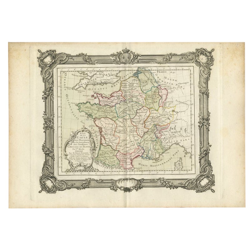
View AllAntique Map of France in the 5th Century by Zannoni, 1765
Located in Langweer, NL
Antique map France titled 'Etat de la Gaule (..)'.
Beautiful old map of France. This map originates from 'Atlas Historique de la France Ancienne et Moderne' by M. Rizzi Zannoni. ...
Category
Antique 18th Century Maps
Materials
Paper
$150 Sale Price
20% Off
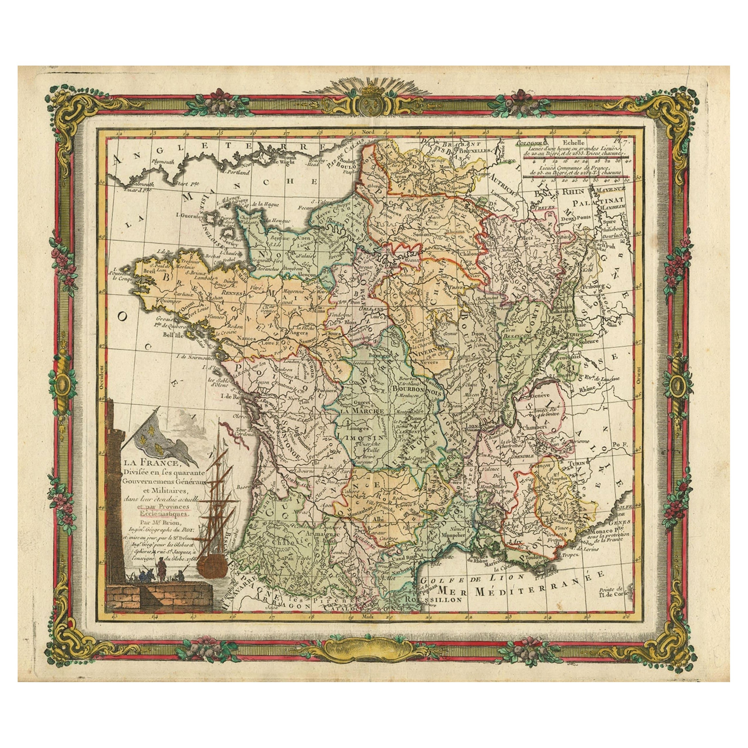
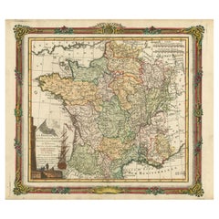
Antique Map of France with Decorative Border, 1766
Located in Langweer, NL
Antique map titled 'La France, divisée en ses quarante Gouvernemens Généraux.' Attractive map of France by Brion de la Tour, published by Desnos. The decorative border was printed fr...
Category
Antique 18th Century Maps
Materials
Paper
$406 Sale Price
20% Off
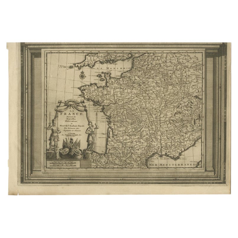
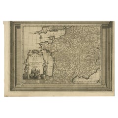
Antique Map of France with Beautiful Title Cartouche and Border, c.1740
Located in Langweer, NL
Antique map titled 'La France suivant les nouvelles Observations de Messrs de l'Academie Royale des Sciences etc.'. Rare map of France with beautiful title cartouche and decorative b...
Category
Antique 18th Century Maps
Materials
Paper
$425 Sale Price
20% Off
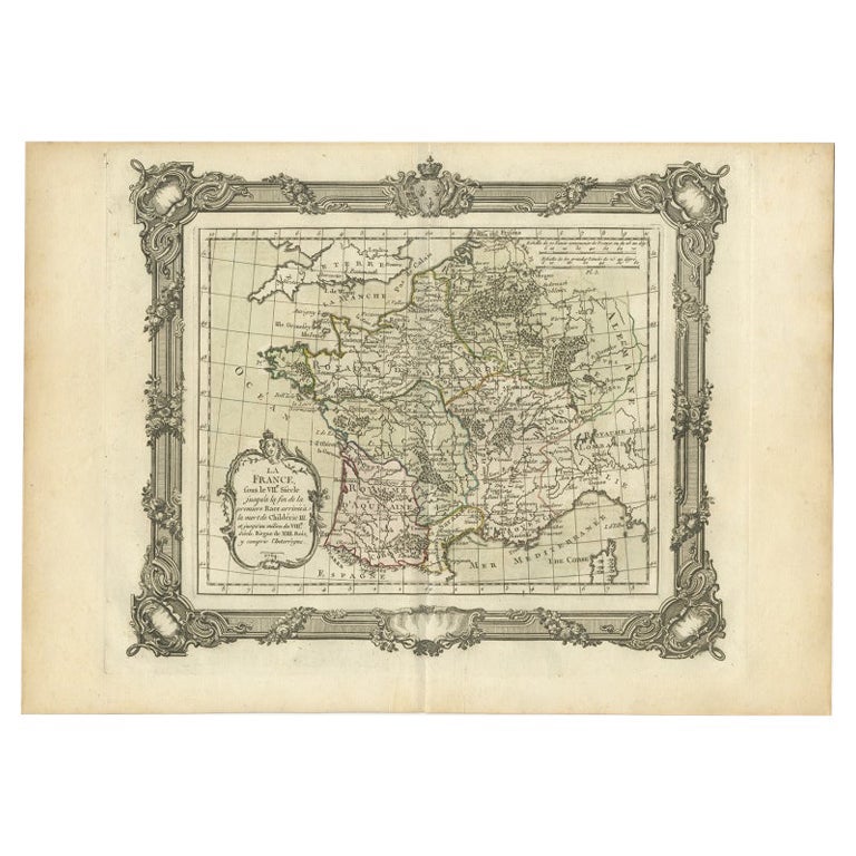
Antique Map of France in the 7th Century by Zannoni, 1765
Located in Langweer, NL
Antique map France titled 'La France sous le VIIe Siècle (..)'. Beautiful old map of France. This map originates from 'Atlas Historique de la France Ancienne et Moderne' by M. Rizzi ...
Category
Antique 18th Century Maps
Materials
Paper
$150 Sale Price
20% Off
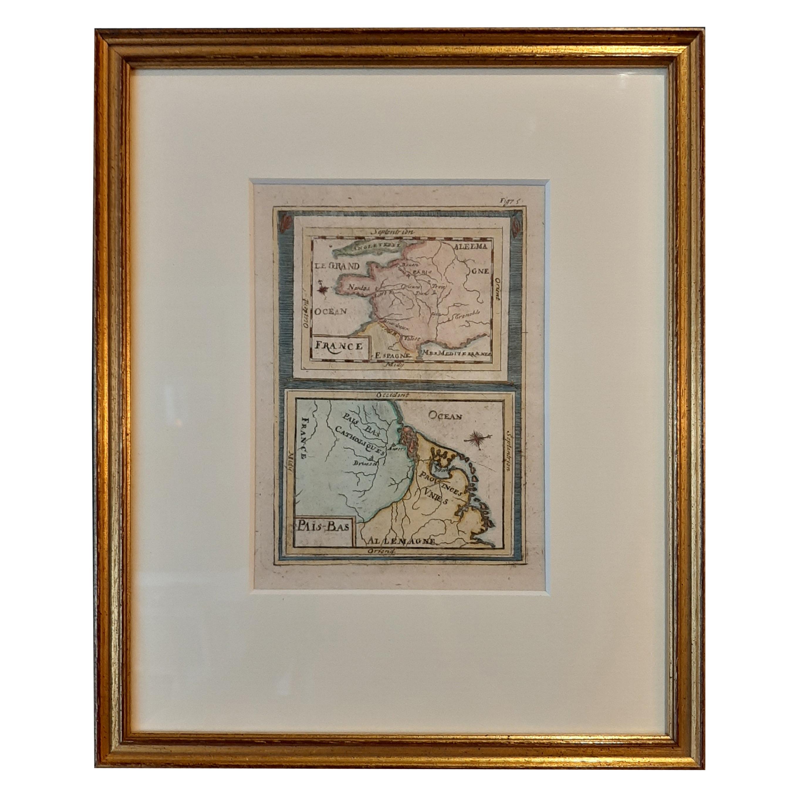
Antique Miniature Map of France and the Low Countries by Mallet, circa 1719
Located in Langweer, NL
Antique map titled 'France - Païs-Bas'. Miniature Map of France and the Low Countries. Published by A.M. Mallet, circa 1719.
Frame included. We carefully pack our framed items to ...
Category
Antique Early 18th Century Maps
Materials
Paper
$165 Sale Price
20% Off
Antique Map of ancient France by Zannoni, 1765
Located in Langweer, NL
Antique map France titled 'Galliae Veteris (..)'. Beautiful old map of France. This map originates from 'Atlas Historique de la France Ancienne et Moderne' ...
Category
Antique 18th Century Maps
Materials
Paper

$302 Sale Price
20% Off
You May Also Like
17th Century Framed Map of Ancient France Titled "Typus Galliae Veteris"
Located in Dallas, TX
Decorate an office or a library with this elegant historic map. Crafted in the Netherlands circa 1630, this beautifully framed antique map with pr...
Category
Antique 17th Century Dutch Baroque Maps
Materials
Glass, Giltwood, Paper

Large 19th Century Map of France
Located in Pease pottage, West Sussex
Large 19th Century Map of France.
Remarkable condition, with a pleasing age worn patina.
Recently framed.
France Circa 1874.
Category
Antique Late 19th Century French Maps
Materials
Linen, Paper

Large Vintage France Map, Continental, Historical Cartography, Late 20th Century
Located in Hele, Devon, GB
This is a large vintage map of France. A Continental, framed example of historical cartography, dating to the late 20th century, circa 1970.
Fas...
Category
Late 20th Century European Mid-Century Modern Prints
Materials
Glass, Wood, Paper

1771 Bonne Map of Poitou, Touraine and Anjou, France, Ric.a015
Located in Norton, MA
1771 Bonne Map of Poitou,
Touraine and Anjou, France
Ric.a015
1771 Bonne map of Potiou, Touraine and Anjou entitled "Carte des Gouvernements D'Anjou et du Saumurois, de la Touraine, du Poitou,du Pays d'aunis, Saintonge?Angoumois,"
Carte des gouvernements d'Anjou et du Saumurois, de la Touraine, du Poitou, du Pays d'Aunis, Saintonge-Angoumois. Projettee et assujettie au ciel par M. Bonne, Hyd. du Roi. A Paris, Chez Lattre, rue St. Jacques a la Ville de Bord(ea)ux. Avec priv. du Roi. 1771. Arrivet inv. & sculp., Atlas moderne ou collection de cartes sur toutes...
Category
Antique 17th Century Unknown Maps
Materials
Paper

Antique Lithography Map, Monmouthshire, Framed, Welsh Cartography, Victorian
Located in Hele, Devon, GB
This is an antique lithography map of Monmouthshire. An English, framed atlas engraving of cartographic interest, dating to the mid 19th century and later.
Superb lithography of Mo...
Category
Antique Mid-19th Century British Victorian Maps
Materials
Glass, Wood, Paper
Antique Map Of Brabantia Ducantus By Bleau Circa 1640
Located in Brussels, Brussels
map of theBrabantia Ducantus (Belgium) circa 1640 by Bléau. Bléau was well known for antique atlas that he draw during the 17 century
beautiful map, double page folded in the middle,...
Category
Antique 17th Century French Renaissance Maps
Materials
Paper

More Ways To Browse
Lighthouse Antique
20th Century Spanish Table
Antonio Bellini
Antique Oushak Carpets
Blue Coffee Tables
German Bauhaus Posters
1945 Chair Juhl
Antique Three Leg Table
Folke Arstrom
Silver Over Copper
Vintage Barware Glasses
Antique Etched Glass
Antique French Shell
Coffee Table Black Italian Modern
Christofle America
Iranian Silk Rug Carpet
Poul Moller
Tables With Inlaid Wood