Items Similar to Original Normandy Map by Frederick de Wit, 1705, with Inset of Channel Islands


Want more images or videos?
Request additional images or videos from the seller
1 of 10
Original Normandy Map by Frederick de Wit, 1705, with Inset of Channel Islands
$1,747.79
£1,318.15
€1,500
CA$2,416.47
A$2,706.85
CHF 1,421.74
MX$32,914.45
NOK 18,003.83
SEK 17,090.47
DKK 11,418.98
About the Item
Normandy Map by Frederick de Wit, 1705, with Inset of Channel Islands
Description:
This beautifully engraved and hand-colored map, titled Duché et Gouvernement General de Normandie, was created by the renowned Dutch cartographer Frederick de Wit and published in Amsterdam in 1705. It offers a detailed depiction of the historic province of Normandy in northern France, precisely divided into Upper and Lower Normandy, along with its principal bailliages and pays. The map is oriented toward the English Channel (La Manche) and features a decorative cartouche adorned with allegorical figures, maritime symbols, and the French royal coat of arms.
A prominent feature of this map is the inset in the upper center, titled *Les Isles de Garnezy Ierzay et Aurigny Font Partie de la Normandie mais elles sont sous la Domaine des Anglois*, which shows the Channel Islands of Guernsey, Jersey, and Alderney. Although politically aligned with England, these islands are geographically and historically part of the Normandy region—a fascinating geopolitical detail emphasized here.
This map gains additional historical significance due to its coverage of key World War II D-Day landing sites, including the coastline stretching from Cherbourg and Utah Beach in the west to Omaha, Gold, Juno, and Sword Beaches further east. Collectors and historians interested in the legacy of the Allied invasion of Normandy on June 6, 1944, will find this piece especially compelling, as it reveals the broader historical context of a region that played a pivotal role in shaping modern Europe.
Printed from copper engraving and measuring approximately 49.5 by 59 cm, this map is from one of De Wit’s atlases compiled after 1688 and remains a testament to early modern cartographic artistry. The original coloring, while slightly oxidized (as the green pigment has browned over time), remains vivid and adds to its antique character.
Condition Report:
Very good overall condition, considering age. Original hand-coloring with expected mild oxidation to green pigments. No tears or major imperfections. Clean margins and strong impression. Condition rating: A.
Framing Tips:
For optimal presentation, we recommend using a UV-protective glass and an archival mount in a neutral or muted gold frame to complement the aged tones. A double mat—ivory with a fine inner line in green or ochre—can enhance visual depth while preserving the antique aesthetic.
Keywords:
Normandy map 1705, Frederick de Wit map, antique French map, Channel Islands inset, D-Day invasion beaches, Utah Beach, Omaha Beach, Sword Beach, Gold Beach, Juno Beach, WW2 Normandy, historical Normandy map, Dutch cartographer, 18th century map of France, antique coastal maps, collectible military maps, La Manche map, vintage Normandy cartography.
- Dimensions:Height: 20.08 in (51 cm)Width: 23.82 in (60.5 cm)Depth: 0.01 in (0.2 mm)
- Materials and Techniques:Paper,Engraved
- Period:1700-1709
- Date of Manufacture:circa 1705
- Condition:Very good overall condition. Original hand-coloring with expected mild oxidation to green pigments. No tears or major imperfections. Clean margins and strong impression. Condition rating: A.
- Seller Location:Langweer, NL
- Reference Number:Seller: BG-14065-11stDibs: LU3054345049312
About the Seller
5.0
Recognized Seller
These prestigious sellers are industry leaders and represent the highest echelon for item quality and design.
Platinum Seller
Premium sellers with a 4.7+ rating and 24-hour response times
Established in 2009
1stDibs seller since 2017
2,517 sales on 1stDibs
Typical response time: <1 hour
- ShippingRetrieving quote...Shipping from: Langweer, Netherlands
- Return Policy
Authenticity Guarantee
In the unlikely event there’s an issue with an item’s authenticity, contact us within 1 year for a full refund. DetailsMoney-Back Guarantee
If your item is not as described, is damaged in transit, or does not arrive, contact us within 7 days for a full refund. Details24-Hour Cancellation
You have a 24-hour grace period in which to reconsider your purchase, with no questions asked.Vetted Professional Sellers
Our world-class sellers must adhere to strict standards for service and quality, maintaining the integrity of our listings.Price-Match Guarantee
If you find that a seller listed the same item for a lower price elsewhere, we’ll match it.Trusted Global Delivery
Our best-in-class carrier network provides specialized shipping options worldwide, including custom delivery.More From This Seller
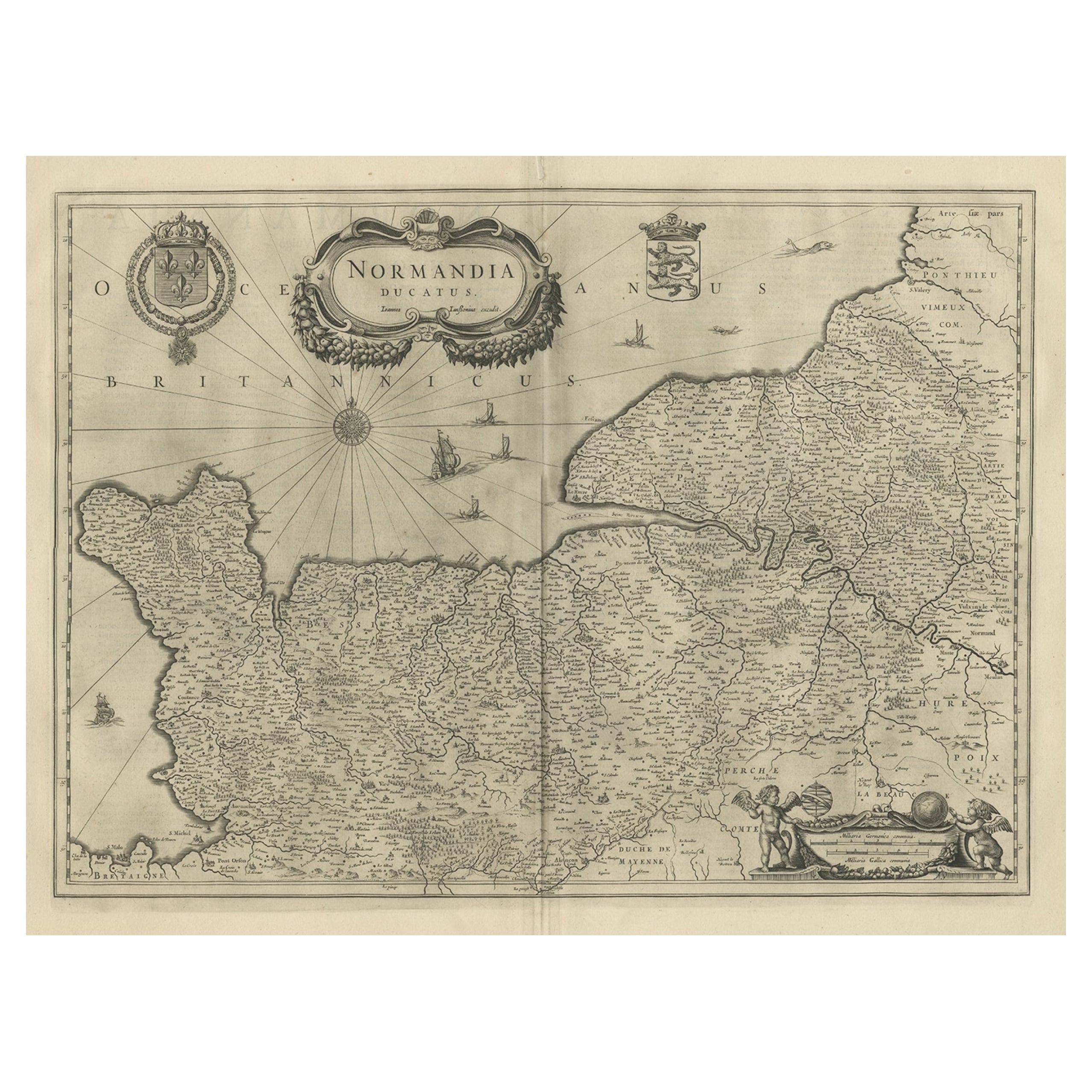
View AllAntique Map of Normandy by Janssonius, 1657
Located in Langweer, NL
Antique map of France titled 'Normandia Ducatus'. Decorative map of the Normandy region, including decorative cartouche, sailing ships and compass rose. This map originates from 'Atl...
Category
Antique 17th Century Maps
Materials
Paper
$333 Sale Price
20% Off
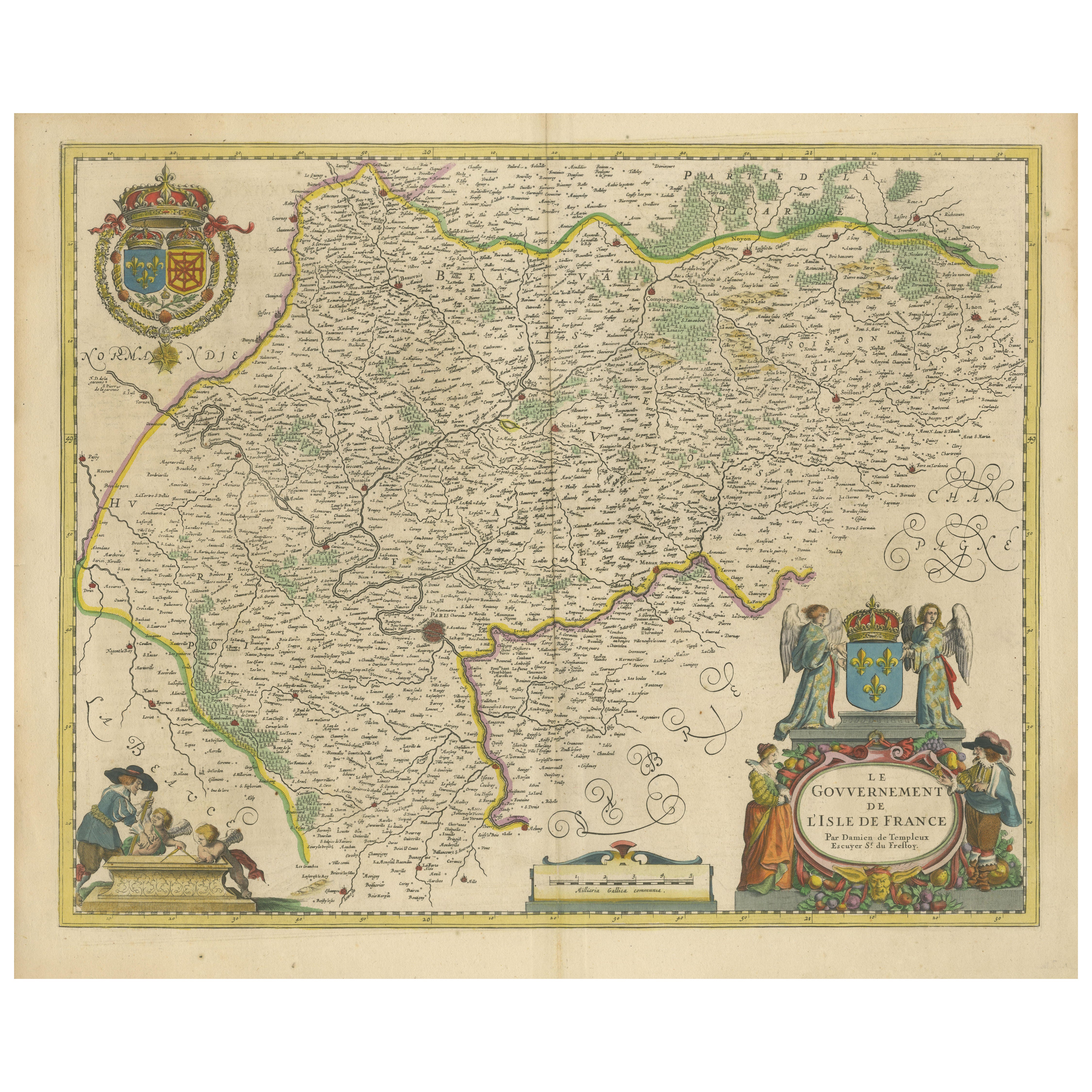
Beautiful 17th Century Map of Paris and Isle de France by Templeux, c.1650
Located in Langweer, NL
Map of Isle de France by D. de Templeux, ca. 1650, Hand-Colored and Decorative
This richly detailed antique map titled *Le Gouvernement de L'Isle de France* was engraved by Daniel d...
Category
Antique 1650s Maps
Materials
Paper

South Sweden Map with Inset of Halmstad – Antique Map by Frederik de Wit, c.1680
Located in Langweer, NL
South Sweden Map with Inset of Halmstad – Antique Map by Frederik de Wit, c.1680
This richly detailed antique map titled Accurata Scaniae, Blekingae et Hallandiae Descriptio present...
Category
Antique Late 17th Century Dutch Maps
Materials
Paper

$787 Sale Price
20% Off
Antique Map of France with the English Channels, 1754
Located in Langweer, NL
Antique map France titled 'An Accurate Map of France drawn from the best authorities'. Small, detailed map of France. With decorative title cartouche.
Ar...
Category
Antique 18th Century Maps
Materials
Paper

$233 Sale Price
20% Off
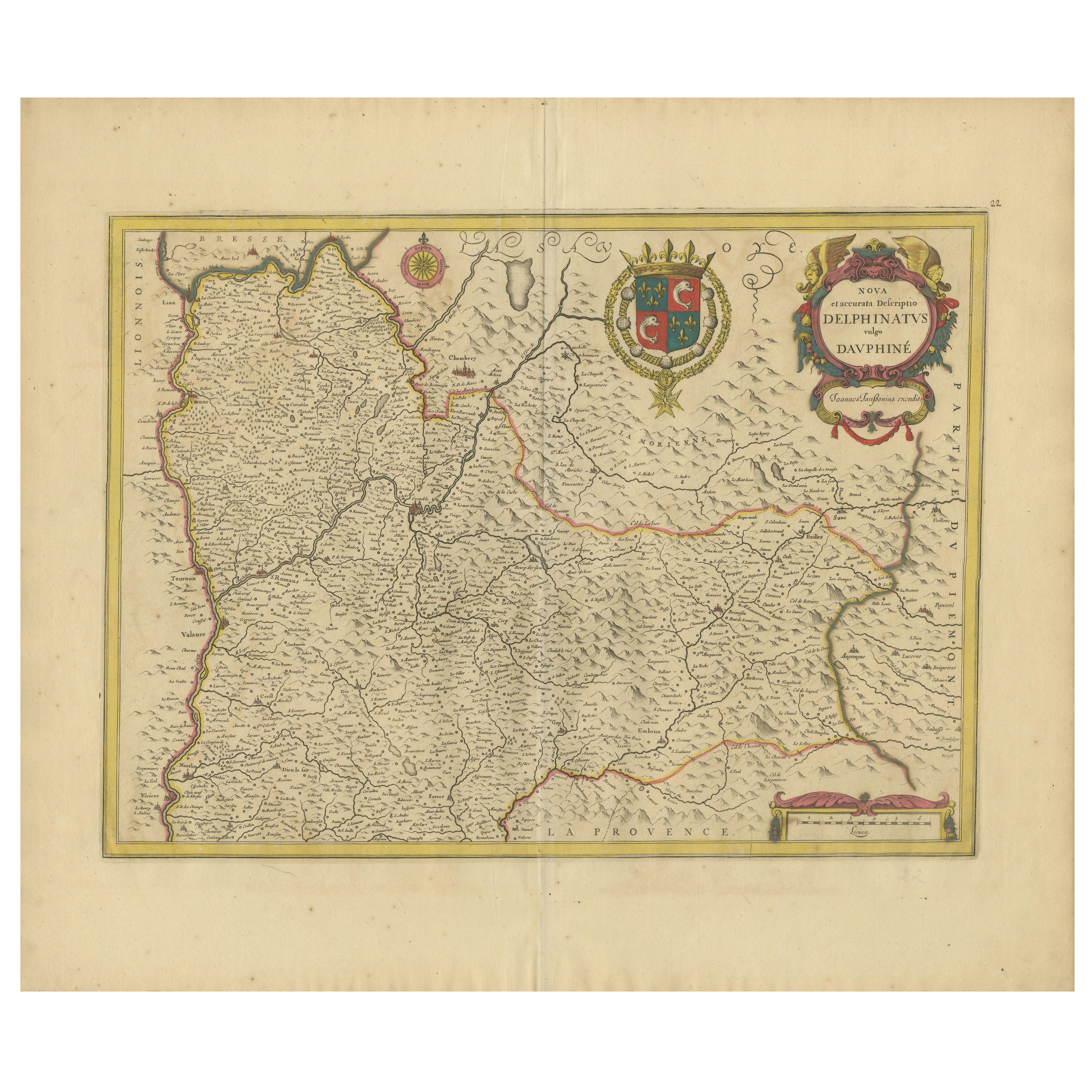
Rare 17th-Century Map of Dauphiné in Southeastern France by F. De Wit, ca.1688
Located in Langweer, NL
Title: Rare Hand-Colored 17th-Century Map of Dauphiné by Frederik De Wit c. 1688
Description: This captivating 17th-century map of Dauphiné, titled "Nova et Accurata Delphinatus Vul...
Category
Antique 1680s Maps
Materials
Paper

Antique Map of the Region of Saintonge by Janssonius, 1657
By Johannes Janssonius
Located in Langweer, NL
Antique map 'La Saintonge vers le Midy avecq le Brovageais'. Decorative map of the Saintonge region, a former province of France located on the west central Atlantic coast. This map ...
Category
Antique Mid-17th Century Maps
Materials
Paper

$559 Sale Price
20% Off
You May Also Like
The Normandy Region of France: A 17th C. Hand-colored Map by Sanson and Jaillot
By Nicolas Sanson
Located in Alamo, CA
This large hand-colored map entitled "Le Duché et Gouvernement de Normandie divisée en Haute et Basse Normandie en divers Pays; et par evêchez, avec le Gouvernement General du Havre ...
Category
Antique 1690s French Maps
Materials
Paper

17th Century Map of Denmark by French Cartographer Sanson, Dated 1658
By Nicolas Sanson
Located in Copenhagen, K
17th century map of Denmark by French cartographer Sanson.
Nicolas Sanson (20 December 1600-7 July 1667) was a French cartographer, termed by some the creator of French geography an...
Category
Antique 17th Century French Maps
Materials
Paper

1643 Willem&Joan Blaeu Map NW Flanders "Flandriae Teutonicae Pars Prientalior
Located in Norton, MA
1643 Willem and Joan Blaeu map of northwest Flanders, entitled
"Flandriae Teutonicae Pars Prientalior,"
Ric0012
" Authentic" - Map of the northwest Fl...
Category
Antique 17th Century Dutch Maps
Materials
Paper

Antique Map - Gallia - Etching by Johannes Janssonius - 1650s
By Johannes Janssonius
Located in Roma, IT
Antique Map - Gallia is an antique map realized in 1650 by Johannes Janssonius (1588-1664).
The Map is Hand-colored etching, with coeval watercoloring.
Good conditions with slight ...
Category
1650s Modern Figurative Prints
Materials
Etching

Prussia, Poland, N. Germany, Etc: A Hand-colored 17th Century Map by Janssonius
By Johannes Janssonius
Located in Alamo, CA
This is an attractive hand-colored copperplate engraved 17th century map of Prussia entitled "Prussia Accurate Descripta a Gasparo Henneberg Erlichensi", published in Amsterdam by Joannes Janssonius in 1664. This very detailed map from the golden age of Dutch cartography includes present-day Poland, Latvia, Lithuania, Estonia and portions of Germany. This highly detailed map is embellished by three ornate pink, red, mint green and gold...
Category
Antique Mid-17th Century Dutch Maps
Materials
Paper

17th Century Hand-Colored Map of a Region in West Germany by Janssonius
By Johannes Janssonius
Located in Alamo, CA
This attractive highly detailed 17th century original hand-colored map is entitled "Archiepiscopatus Maghdeburgensis et Anhaltinus Ducatus cum terris adjacentibus". It was published ...
Category
Antique Mid-17th Century Dutch Maps
Materials
Paper
