Items Similar to Original Old Map of Present-Day Mongolia, Northeast China and Korea


Want more images or videos?
Request additional images or videos from the seller
1 of 6
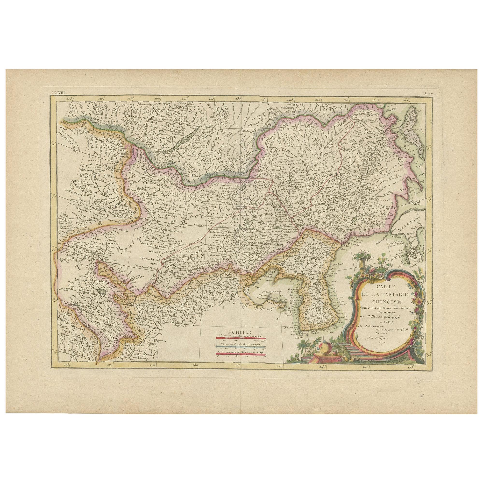
Original Old Map of Present-Day Mongolia, Northeast China and Korea
$1,140.63
$1,425.7920% Off
£848.97
£1,061.2120% Off
€952
€1,19020% Off
CA$1,562.38
CA$1,952.9820% Off
A$1,737.71
A$2,172.1420% Off
CHF 907.38
CHF 1,134.2220% Off
MX$21,146.08
MX$26,432.5920% Off
NOK 11,588.60
NOK 14,485.7520% Off
SEK 10,868.06
SEK 13,585.0820% Off
DKK 7,247.24
DKK 9,059.0520% Off
Shipping
Retrieving quote...The 1stDibs Promise:
Authenticity Guarantee,
Money-Back Guarantee,
24-Hour Cancellation
About the Item
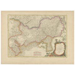
Antique map titled 'Carte de la Tartarie Chinoise. Projettee et assujettie aux observations astronomiques par M. Bonne, Hydrographe du Roi. A Paris, Chez Lattre Graveur, ordinaire de Mseur. Le Dauphin, rue S. Jacques a la Ville de Bordeaux. Avec privilege du Roy. 1771'. Original old map of the region including present-day Mongolia, northeast China and Korea. Published in Paris by Lattré in “Atlas Moderne”, 1771. This atlas contained many maps by Rigobert Bonne.
- Dimensions:Height: 15.24 in (38.7 cm)Width: 21.19 in (53.8 cm)Depth: 0.02 in (0.5 mm)
- Materials and Techniques:
- Period:
- Date of Manufacture:1771
- Condition:Wear consistent with age and use. General age-related toning. Original folding line. Minor wear and soiling, blank verso. Small repair on tiny holes above scale. Please study image carefully.
- Seller Location:Langweer, NL
- Reference Number:Seller: BG-13370-11stDibs: LU3054332541102
About the Seller
5.0
Recognized Seller
These prestigious sellers are industry leaders and represent the highest echelon for item quality and design.
Platinum Seller
Premium sellers with a 4.7+ rating and 24-hour response times
Established in 2009
1stDibs seller since 2017
2,508 sales on 1stDibs
Typical response time: <1 hour
- ShippingRetrieving quote...Shipping from: Langweer, Netherlands
- Return Policy
Authenticity Guarantee
In the unlikely event there’s an issue with an item’s authenticity, contact us within 1 year for a full refund. DetailsMoney-Back Guarantee
If your item is not as described, is damaged in transit, or does not arrive, contact us within 7 days for a full refund. Details24-Hour Cancellation
You have a 24-hour grace period in which to reconsider your purchase, with no questions asked.Vetted Professional Sellers
Our world-class sellers must adhere to strict standards for service and quality, maintaining the integrity of our listings.Price-Match Guarantee
If you find that a seller listed the same item for a lower price elsewhere, we’ll match it.Trusted Global Delivery
Our best-in-class carrier network provides specialized shipping options worldwide, including custom delivery.More From This Seller
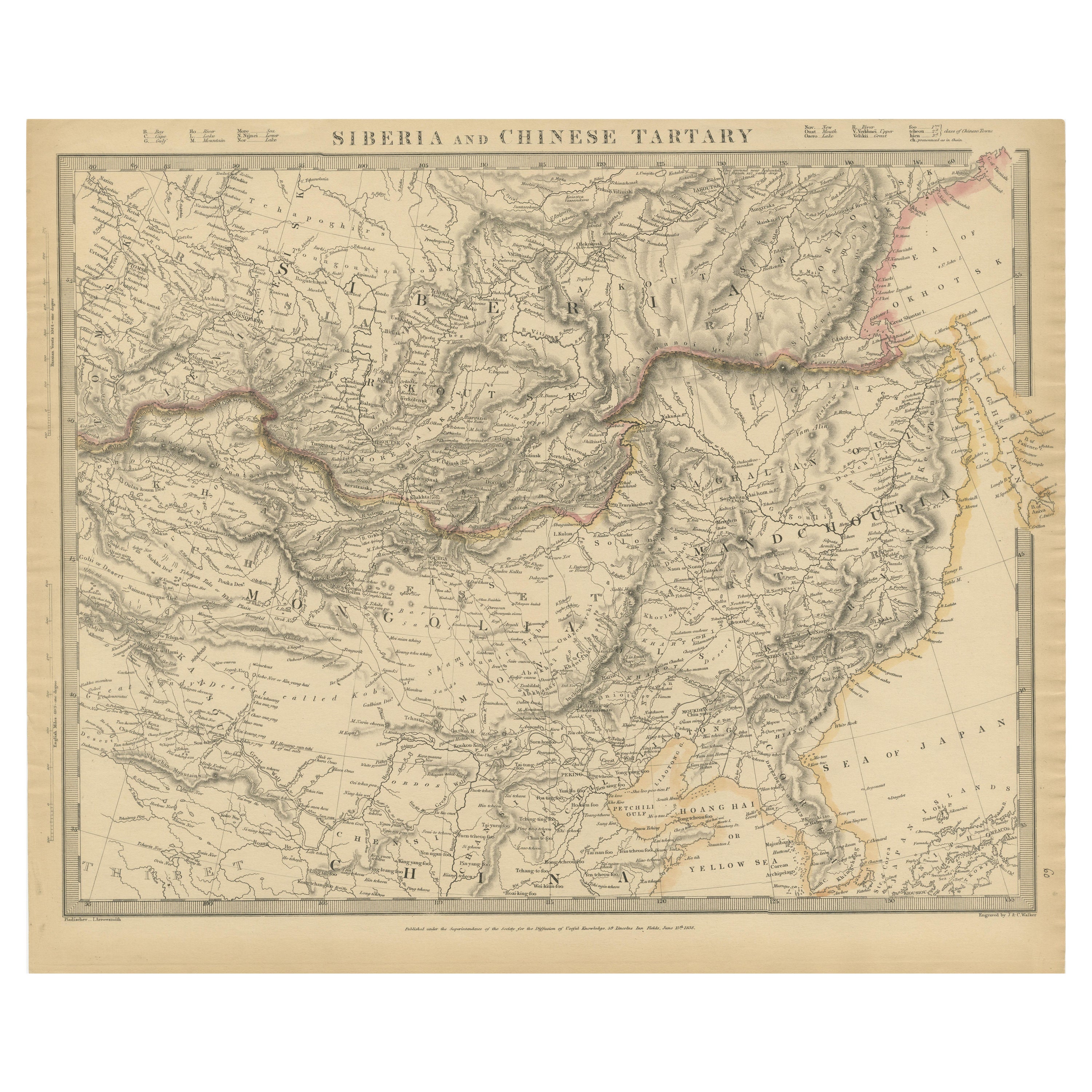
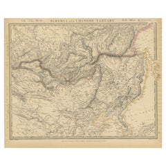
View AllAntique Map of the region of Siberia, Mongolia and Manchuria
Located in Langweer, NL
Antique map titled 'Siberia and Chinese Tartary'. Detailed antique map of the region of Siberia, Mongolia and Manchuria. Engraved by J. & C. Walker. Published 1838.
Category
Antique Mid-19th Century Maps
Materials
Paper
$364 Sale Price
20% Off
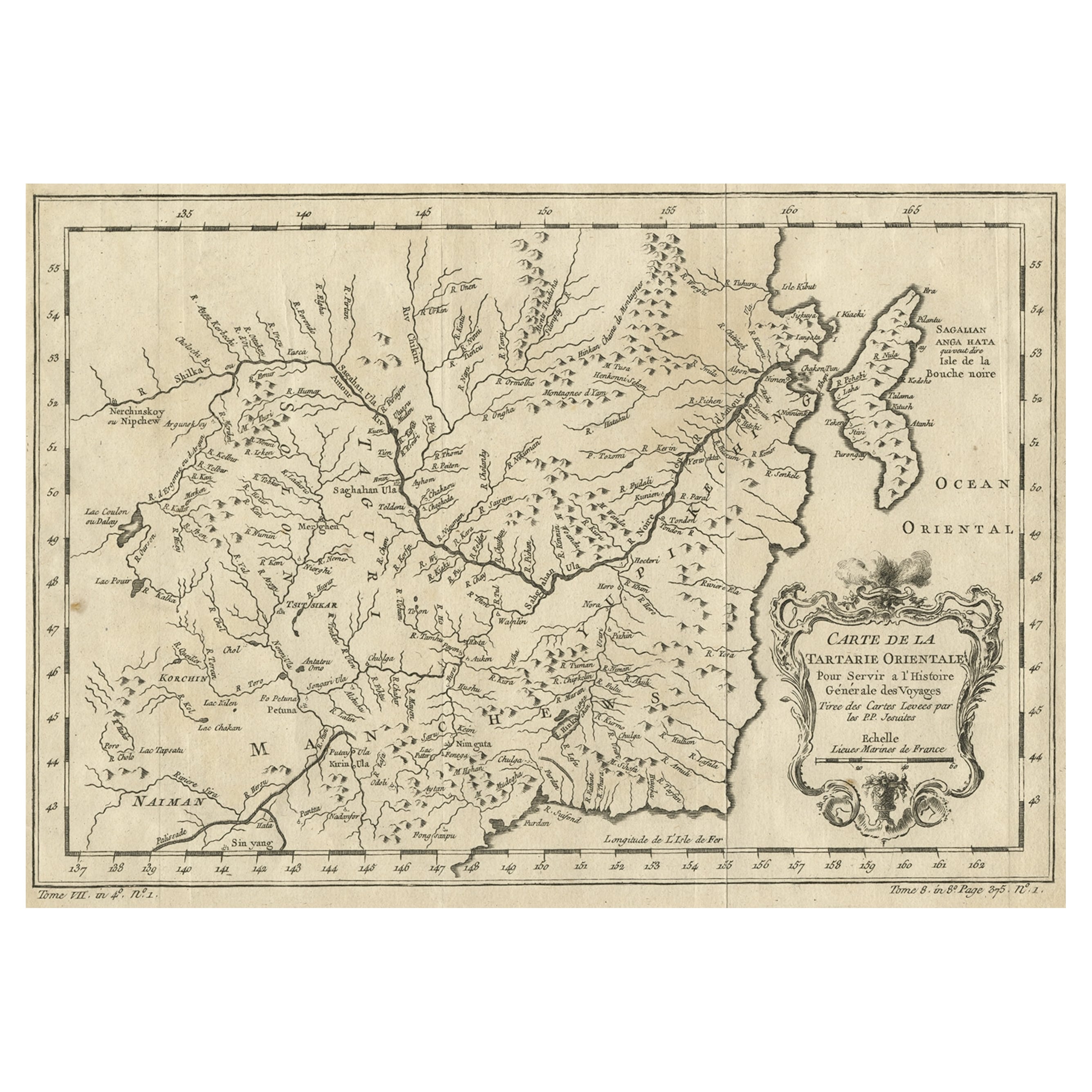
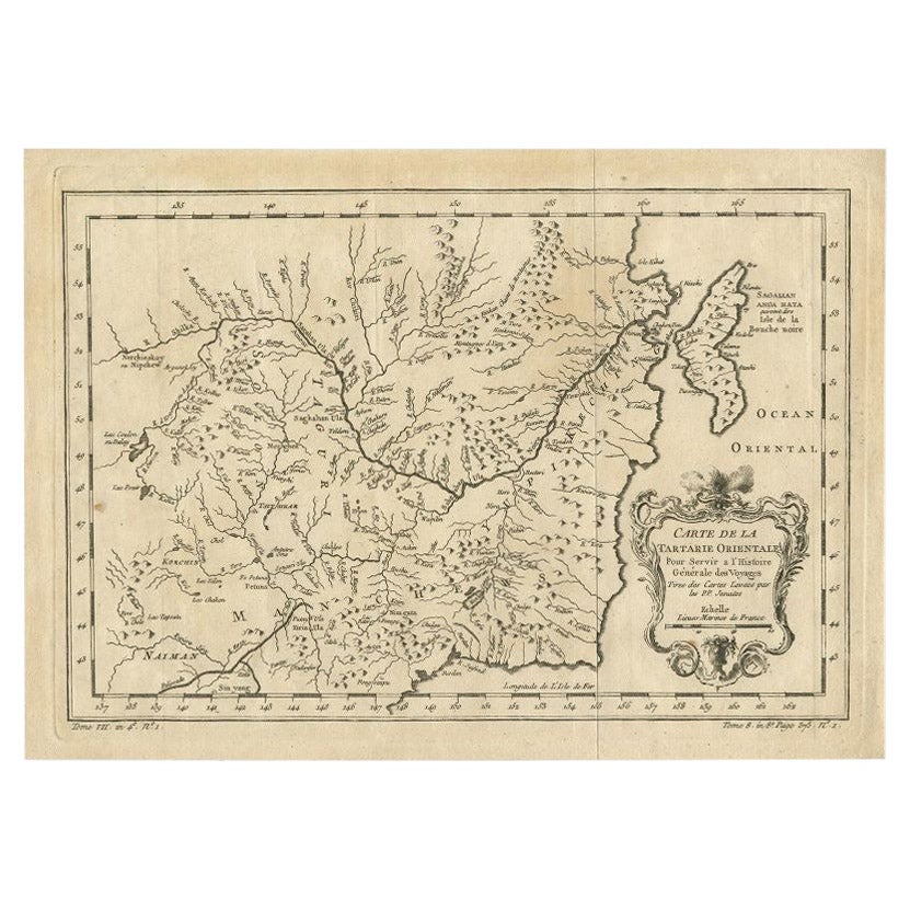
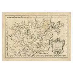
Antique Map of Manchuria and the Northeast Portion of Tartary
Located in Langweer, NL
Antique map titled 'Carte de la Tartarie Orientale (..)'. Detailed map of Manchuria and the Northeast portion of Tartary, including Sagallan Anga Hata--Isle de la Bouche...
Category
Antique Mid-18th Century Maps
Materials
Paper

$277 Sale Price
20% Off
Antique Map of Korea and Southern China by Bonne '1771'
Located in Langweer, NL
Antique map titled 'Carte de la Tartarie Chinoise'. Original antique map of Korea and Southern China. Covers from the Lop Nor region eastward to K...
Category
Antique Mid-18th Century Maps
Materials
Paper
$551 Sale Price
20% Off
Antique Map of Northern China and Far Eastern Russia Around the Amur River, 1754
Located in Langweer, NL
Antique map titled 'Carte De La Tartarie Orientale (..)'. A map for this far eastern portion of what is present day northern China and far eastern Russia...
Category
Antique 1750s Maps
Materials
Paper

$479 Sale Price
20% Off
Original Antique Map of Tartary 'Northern China & Far Eastern Russia', 1757
Located in Langweer, NL
Antique map titled 'Carte de la Tartarie Orientale (..)'.
Original antique map of what is present day northern China and far eastern Russia. Centere...
Category
Antique 1750s Maps
Materials
Paper

$277 Sale Price
20% Off
Antique Map of Northern China and Eastern Russia by Bellin, 1757
Located in Langweer, NL
Antique map titled 'Carte de la Tartarie Orientale (..)'. Original antique map of what is present day northern China and far eastern Russia. Centered on...
Category
Antique 18th Century Maps
Materials
Paper
You May Also Like
Antique French Map of Asia Including China Indoneseia India, 1783
Located in Amsterdam, Noord Holland
Very nice map of Asia. 1783 Dedie au Roy.
Additional information:
Country of Manufacturing: Europe
Period: 18th century Qing (1661 - 1912)
Condition: Overall Condition B (Good Used)...
Category
Antique 18th Century European Maps
Materials
Paper

$648 Sale Price
20% Off
Antique 1803 Italian Map of Asia Including China Indoneseia India
Located in Amsterdam, Noord Holland
Antique 1803 Italian Map of Asia Including China Indoneseia India
Very nice map of Asia. 1803.
Additional information:
Type: Map
Country of Manufacturing: Europe
Period: 19th centu...
Category
Antique 19th Century European Maps
Materials
Paper

$584 Sale Price
20% Off
Super Rare Antique French Map of Chine and the Chinese Empire, 1780
Located in Amsterdam, Noord Holland
Super Rare Antique French Map of Chine and the Chinese Empire, 1780
Very nice map of Asia. 1780 Made by Bonne.
Additional information:
Type: Map
...
Category
Antique 18th Century European Maps
Materials
Paper

$584 Sale Price
33% Off
Original Antique Map of China, Arrowsmith, 1820
Located in St Annes, Lancashire
Great map of China
Drawn under the direction of Arrowsmith
Copper-plate engraving
Published by Longman, Hurst, Rees, Orme and Brown, 1820
Unfr...
Category
Antique 1820s English Maps
Materials
Paper

1849 Map of "Europaische Russland", 'Meyer Map of European Russia', Ric. R017
Located in Norton, MA
1849 Map of
"Europaische Russland"
( Meyer Map of European Russia)
Ric.r017
A lovely map of European Russia dating to 1849 by Joseph Meyer. It covers the European portions of...
Category
Antique 19th Century Unknown Maps
Materials
Paper

Ancient National Atlas of France with Marengo
Located in Alessandria, Piemonte
Ancient National Atlas of France with the department of Marengo: a rare French etching dated 1806.
ST/178.
Category
Antique Early 19th Century French Other Prints
Materials
Paper

More Ways To Browse
Mongolia Antique
Antique Mongolian Furniture
Mongolian Antique
Le Roy Paris
J And C Bavaria
Map Of Barbados
Montreal Map
Antique Furniture Toledo Ohio
Laos Antique Map
Orinoco Furniture
Johann Baptist Homann On Sale
Rand Mcnally Vintage Maps
Tipu Sultan
Antique Map Bermuda
Antique Map Holder
Lancashire Map
Maltese Falcon
Raised Relief Map