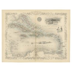
Ornate Cartography of Colonial Grandeur: The West India Islands around 1851
View Similar Items

Want more images or videos?
Request additional images or videos from the seller
1 of 6
Ornate Cartography of Colonial Grandeur: The West India Islands around 1851
Price:$219.69
$342.54List Price
About the Item
- Dimensions:Height: 10.71 in (27.2 cm)Width: 14.26 in (36.2 cm)Depth: 0 in (0.02 mm)
- Materials and Techniques:
- Period:
- Date of Manufacture:1851
- Condition:Good given age. Original fold in middle as published. General age-related toning, please study scan carefully.
- Seller Location:Langweer, NL
- Reference Number:Seller: BG-13736-181stDibs: LU3054339299012
About the Seller
5.0
Recognized Seller
These prestigious sellers are industry leaders and represent the highest echelon for item quality and design.
Platinum Seller
Premium sellers with a 4.7+ rating and 24-hour response times
Established in 2009
1stDibs seller since 2017
2,534 sales on 1stDibs
Authenticity Guarantee
In the unlikely event there’s an issue with an item’s authenticity, contact us within 1 year for a full refund. DetailsMoney-Back Guarantee
If your item is not as described, is damaged in transit, or does not arrive, contact us within 7 days for a full refund. Details24-Hour Cancellation
You have a 24-hour grace period in which to reconsider your purchase, with no questions asked.Vetted Professional Sellers
Our world-class sellers must adhere to strict standards for service and quality, maintaining the integrity of our listings.Price-Match Guarantee
If you find that a seller listed the same item for a lower price elsewhere, we’ll match it.Trusted Global Delivery
Our best-in-class carrier network provides specialized shipping options worldwide, including custom delivery.More From This Seller
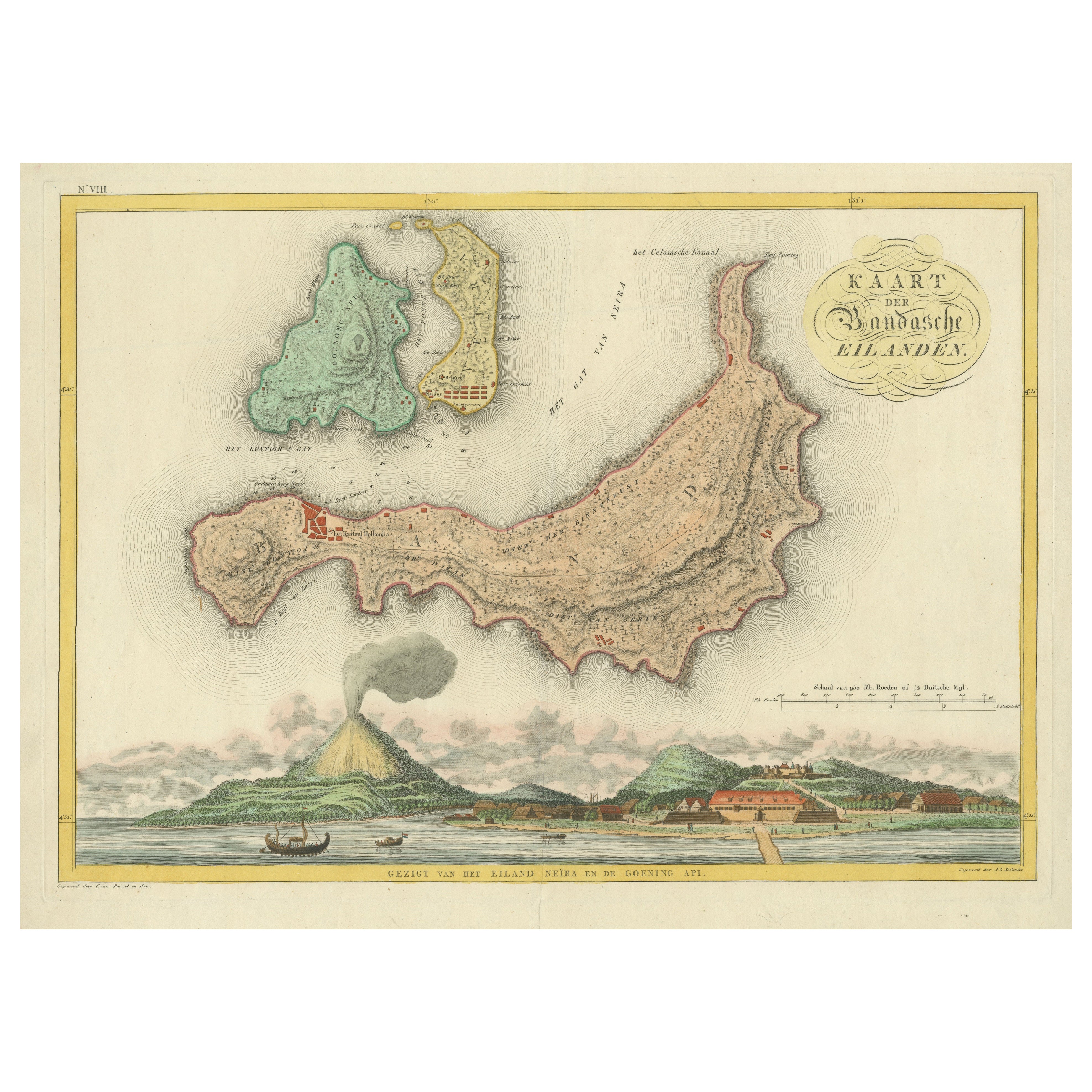
View AllColonial Cartography: The Banda Islands - the Epicenter of the Spice Trade, 1818
Located in Langweer, NL
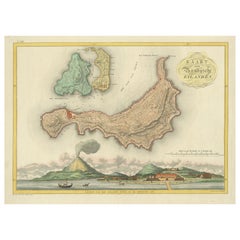
Antique map titled 'Kaart der Bandasche Eilanden' with a view titled 'Gezigt van het Eiland Neira en de Goening Api'. Rare and attractive map of the Banda Islands with a large view of Banda Neira and Gunung Api. One of 12 maps from ‘Atlas van Overzeesche bezittingen’ (Atlas of Oversea Possessions) by J.S. van den Bosch. J.S. van den Bosch (1780 – 1844), Major General, Knight of the 3rd Class of the Military William Order.
It is a rare and visually appealing representation of the Banda Islands, a group of ten small volcanic islands in the Banda Sea, part of present-day Indonesia.
The map is one of twelve from the “Atlas van Overzeesche bezittingen” (Atlas of Overseas Possessions) by J.S. van den Bosch, who was a Major General and a Knight of the Military William Order. Johannes van den Bosch, who lived from 1780 to 1844, had a significant military and administrative career, including serving as Governor-General of the Dutch East Indies. His works and collections are reflective of the Dutch colonial interest and administration in the region.
The Banda Islands, depicted in this map, are particularly famous for being the sole source of nutmeg and mace before the mid-19th century. Nutmeg was highly valued in European cuisine, as a preservative, and as a medicine. The monopoly on these spices made the Banda Islands extremely important during the age of spice trade, which also led to intense colonial competition and conflict, notably between the Dutch and the British.
The map itself provides a detailed topographical representation of the Banda Islands, possibly with depth soundings and navigational hazards indicated, which would have been essential information for the ships of the Dutch East India Company and other seafarers. The large view of Banda Neira and Gunung Api (literally "Fire Mountain...
Category
Antique Early 19th Century Maps
Materials
Paper
$793 Sale Price
20% Off
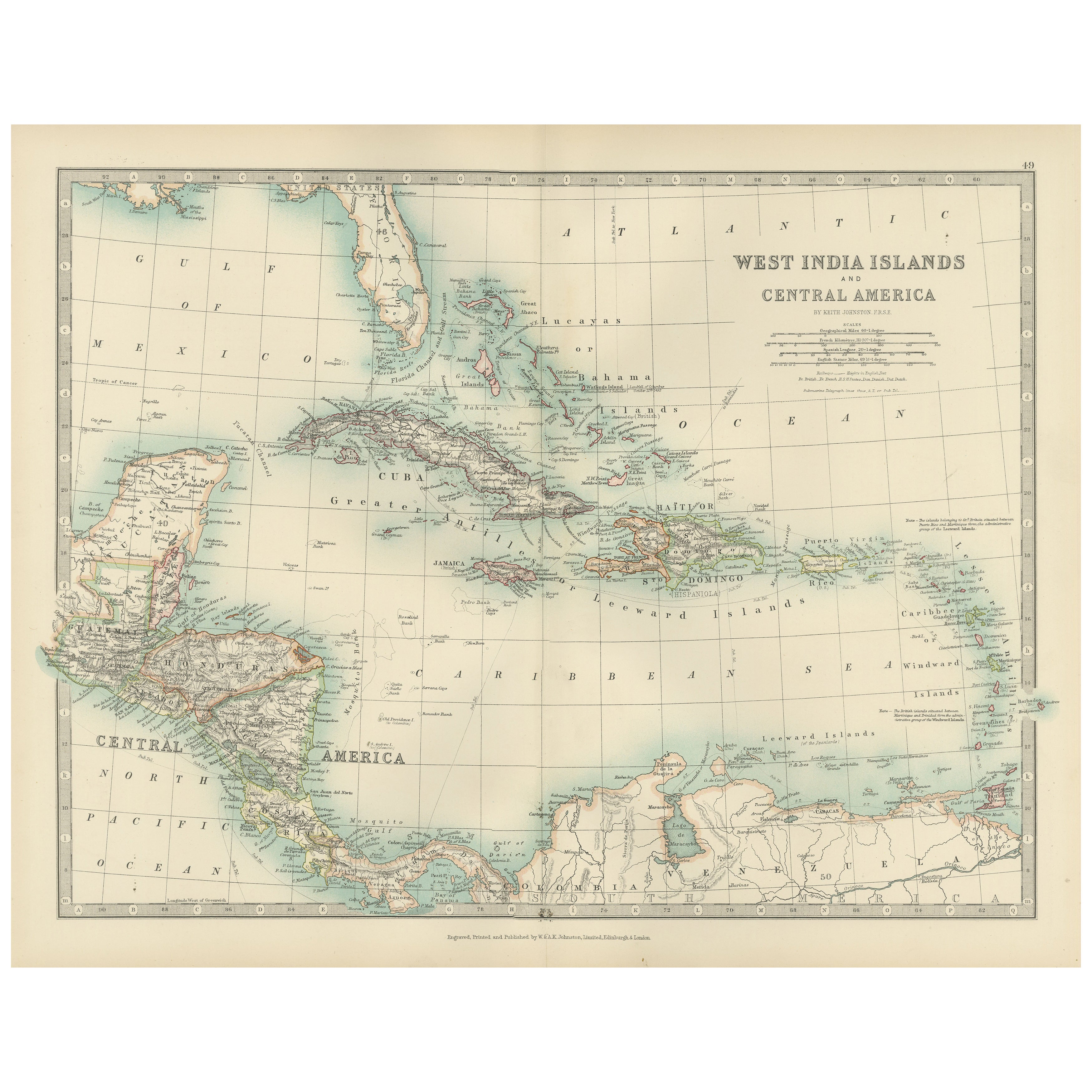
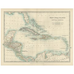
Map of the West India Islands and Central America – Colorful 1903 Engraving
Located in Langweer, NL
Map of the West India Islands and Central America – Colorful 1903 Engraving
This vibrant engraved map, titled "West India Islands and Central America," was created by Keith Johnston...
Category
Early 20th Century Maps
Materials
Paper
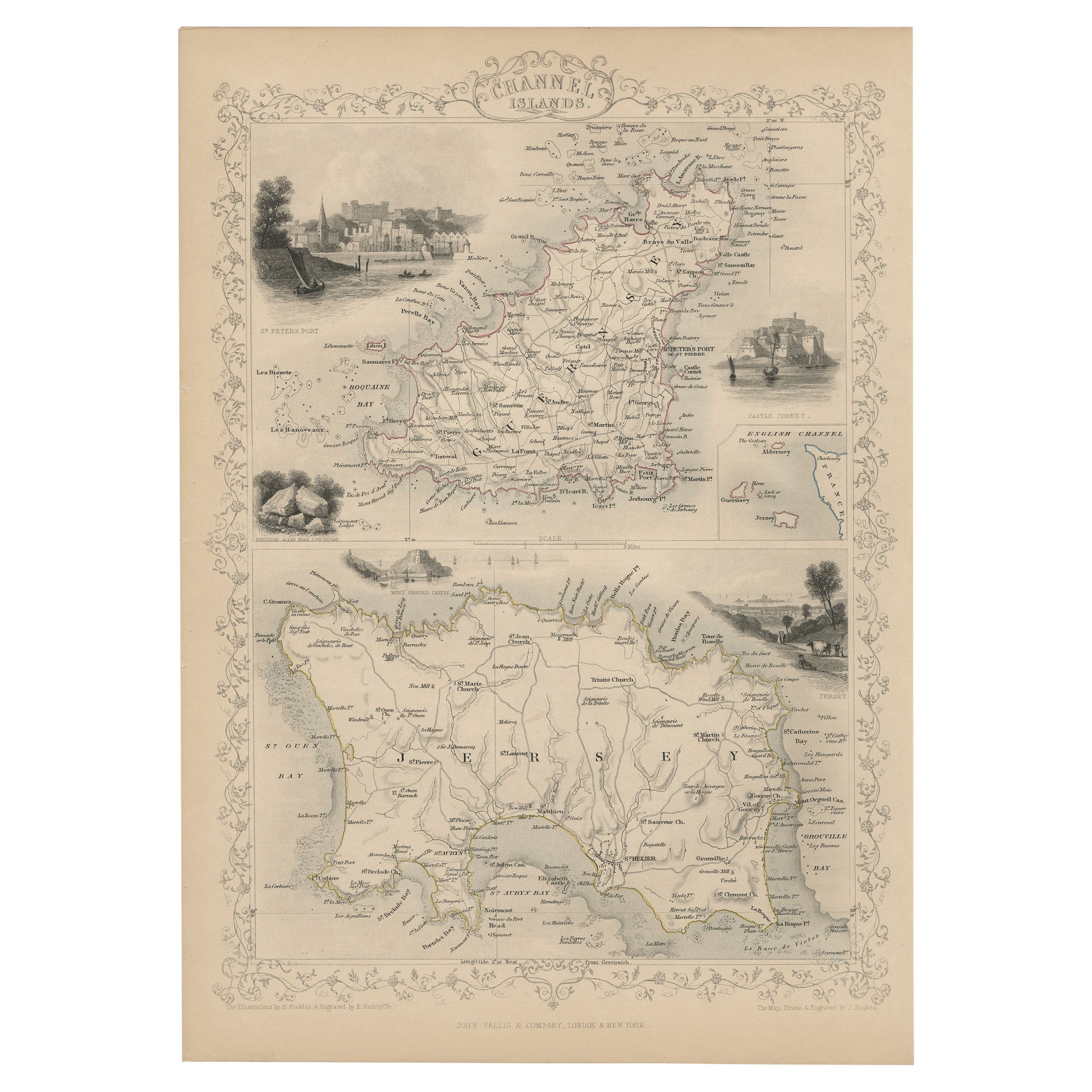
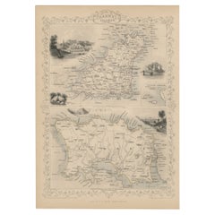
Original Antique Map of the Channel Islands, Incl. Decorative Vignettes, 1851
Located in Langweer, NL
Antique map titled ‘Channel Islands’.
Includes decorative vignettes titled St. Peters Port, Castle Cornet, Druidical altar near Lancresse, Mont Orgueil Castle and Jersey. Originates from 'The Illustrated Atlas, And Modern History Of The World Geographical, Political, Commercial & Statistical, Edited By R. Montgomery Martin'. Published; John Tallis London, New York, Edinburgh & Dublin. 1851. Drawn and Engraved by J. Rapkin.
Artists and engravers: John Tallis (1817-1876) was a British map...
Category
Antique 1850s Maps
Materials
Paper
$425 Sale Price
20% Off
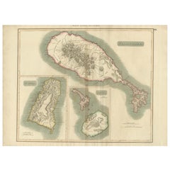
Hand-Colored Map of West India Islands: St. Christopher's, St. Lucia and Nevis
Located in Langweer, NL
This map, titled "West India Islands," was published by John Thomson & Co. in 1821 as part of *Thomson's New General Atlas.* The map offers detailed depictions of three key islands i...
Category
Antique 1820s Maps
Materials
Paper
$548 Sale Price
20% Off
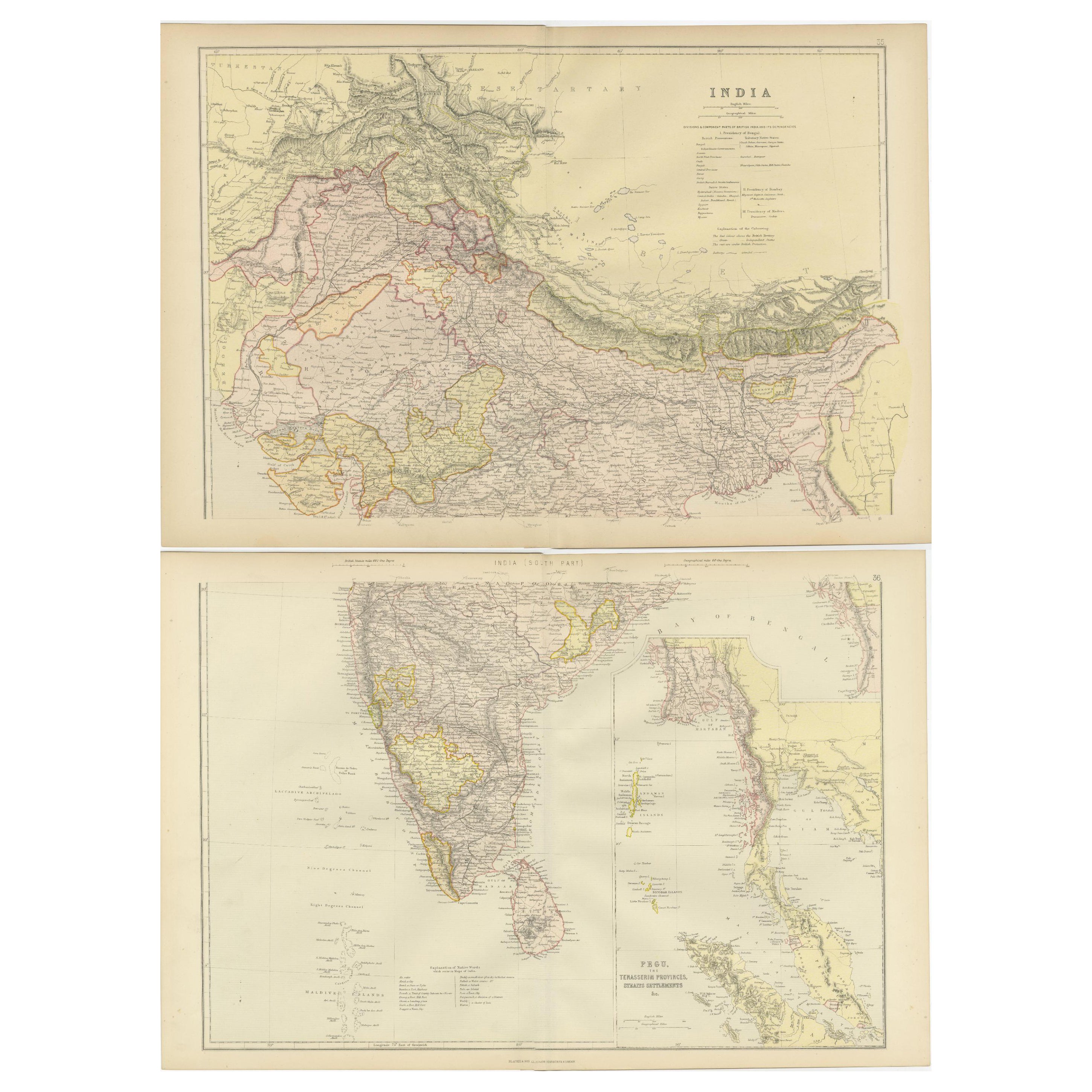
Vintage Cartographic Collection Set of India Explored - W. G. Blackie's 1859
Located in Langweer, NL
Antique map titled 'India'. Original antique map of India with inset maps of Pegu, the Tenasserim Provinces, straits settlements. This map originate...
Category
Antique Mid-19th Century Maps
Materials
Paper
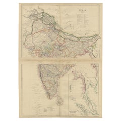
$377 Sale Price / set
20% Off
Decorative Antique Map of the Malay Archipelago or East Indies Island, 1851
Located in Langweer, NL
Antique map Indonesia titled 'Malay Archipelago, or East India Islands'. With vignettes of Victoria Mount, New Guinea, Nativaes of New Guinea an...
Category
Antique 1850s Maps
Materials
Paper
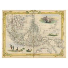
$1,039 Sale Price
20% Off
You May Also Like
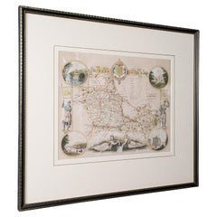
Antique West Yorkshire Map, English, Framed Lithography, Cartography, Victorian
Located in Hele, Devon, GB
This is an antique lithography map of West Yorkshire. An English, framed atlas engraving of cartographic interest, dating to the mid 19th century and later.
Superb lithography of t...
Category
Antique Mid-19th Century British Victorian Maps
Materials
Paper
Antique Lithography Map, West Africa, English, Framed, Cartography, Victorian
Located in Hele, Devon, GB
This is an antique lithography map of Western Africa. An English, framed atlas engraving of cartographic interest by John Rapkin, dating to the early Victorian period and later, circ...
Category
Antique Mid-19th Century British Early Victorian Maps
Materials
Wood

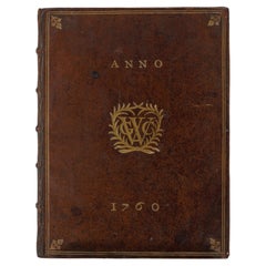
A Dutch West India Company GWC almanack for the year 1760
Located in Amsterdam, NL
"D'Erven Stichter’s Comptoir Almanach, Op ’t Schrikkel-Jaar onzes Heeren Jesu Christi, 1760, voorzien met alle de Jaar-, Paarden-, Beesten-, en Leermarkten Alsmede de Vacantien, het ...
Category
Antique 18th Century Dutch Books
Materials
Leather, Paper
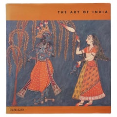
The Art of India
Located in Bradenton, FL
The Art of India. Hardcover book with dustjacket. First edition, published in 1997 by Laurel Glen Publishing. Illustrated, 97 pages.
Category
Late 20th Century Books
Materials
Paper
$125
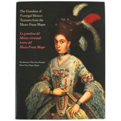
The Grandeur of Viceregal Mexico; Treasures from the Museo Franz Mayer
Located in valatie, NY
The Grandeur of Viceregal Mexico; Treasures from the Museo Franz Mayer. Houston: The Museum of Fine Arts, 2002. First edition hardcover with dust jacket. Spanish and English text. 36...
Category
21st Century and Contemporary American Books
Materials
Paper
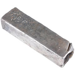
Colonial Silver VOC 'East-India Company' Ingot
Located in Amsterdam, NL
A silver 'V.O.C. AMSTERDAM' ingot
circa 1738, with monogram and the assay mark of the Amsterdam Grill family
With V.O.C. monogram and the A for Amsterdam.
L. approx. 15.5 cm
Weight approx. 2000 grams
Note:
The ingots were salvaged in 2004 from the wreck of the VOC indiaman Rooswijk, equipped by the Amsterdam VOC Chamber. The Rooswijk sank on its second voyage to the Dutch East Indies off the English coast on the Goodwin Sands...
Category
Antique 18th Century Dutch Historical Memorabilia
Materials
Sterling Silver
Recently Viewed
View AllMore Ways To Browse
Puerto Rico Mid Century Furniture
John Powers
Antique Oushak Carpets
Blue Coffee Tables
1945 Chair Juhl
Antique Three Leg Table
Folke Arstrom
Silver Over Copper
Vintage Barware Glasses
Antique Etched Glass
Antique French Shell
Coffee Table Black Italian Modern
Christofle America
Iranian Silk Rug Carpet
Poul Moller
Tables With Inlaid Wood
World War Table
Antonio Jacobsen