Items Similar to An Ornate and Historical Tallis Map of Jamaica with Decorative Vignettes, 1851


Want more images or videos?
Request additional images or videos from the seller
1 of 7
An Ornate and Historical Tallis Map of Jamaica with Decorative Vignettes, 1851
$277.97
$347.4620% Off
£206.89
£258.6120% Off
€232
€29020% Off
CA$380.75
CA$475.9420% Off
A$423.48
A$529.3420% Off
CHF 221.13
CHF 276.4120% Off
MX$5,153.25
MX$6,441.5620% Off
NOK 2,824.11
NOK 3,530.1420% Off
SEK 2,648.52
SEK 3,310.6520% Off
DKK 1,766.14
DKK 2,207.6720% Off
Shipping
Retrieving quote...The 1stDibs Promise:
Authenticity Guarantee,
Money-Back Guarantee,
24-Hour Cancellation
About the Item
This original antique map of Jamaica is part of the renowned series created by the Tallis Company, known for their detailed and decorative maps of the 19th century. The company was founded by John Tallis, who was an English cartographic publisher. His maps are especially noted for their ornate borders and vignettes that illustrate various cultural and geographic aspects of the regions they depict.
The map itself is an intricate representation of Jamaica during the era of the British Empire, detailed with regions, towns, and geographical features such as mountains and rivers. Jamaica, an island in the Caribbean, was a British colony at the time this map was produced. It is known for its rich history, including its indigenous Taino people, Spanish conquest, and subsequent British colonization, and it was a significant hub in the transatlantic slave trade.
The vignettes surrounding the map offer a glimpse into the life and landscapes of Jamaica during the colonial period. They typically depict scenes of local importance or characteristic activities, giving additional context to the map itself. In this case, the scenes likely show various aspects of Jamaican society and economy, such as plantation life, which was a crucial part of the island's history given its role in sugar production.
The British Colonies by Robert Montgomery Martin, who was a colonial administrator, statistician, and author, is a comprehensive account of the British Empire's territories during the height of its power. His works provided detailed descriptions and statistics, aiming to inform the British public and officials about the vast expanse and diversity of the empire.
The Tallis maps, including this map of Jamaica, are collector's items today, prized for their beauty and historical value. They represent an era of extensive British exploration, colonization, and cartography, reflecting the Victorian interest in the broader world and the British role within it.
More details on the insets:
The insets on the map of Jamaica are detailed vignettes that illustrate various locales and features of the island, and they are a distinctive characteristic of John Tallis' maps. Here are the descriptions of the insets provided in the images:
1. **Port Antonio**: This vignette shows a coastal scene with a view of the town of Port Antonio. The image depicts several ships in the harbor and the town spread out along the coast, set against a backdrop of rolling hills or mountains in the distance. The foliage is lush, which is characteristic of the Jamaican landscape.
2. **Port Royal Harbour**: The vignette captures the serene waters of Port Royal Harbour with several boats sailing or docked in the calm bay. In the background, the Blue Mountains rise, which is a notable geographic feature of Jamaica known for its natural beauty and the famous coffee that is grown in its highlands.
3. **Seal of the Colony**: At the center of the top part of the map, there is the depiction of the "Seal of the Colony" which would be the official seal used during the British colonial administration. It represents the authority and governance of the time.
4. **Kingston**: This vignette features the city of Kingston, the capital and largest city of Jamaica. It shows a panoramic view of the city with buildings and vegetation. The scene is from a vantage point that looks over the city towards the harbor, showing a few ships and the ocean in the background.
5. **Fish with Wings (Flying Fish)**: The bottom vignette on the map shows a "fish with wings," which could represent a flying fish, a species known to frequent the waters around Jamaica. It adds an element of the local fauna to the map and highlights the island's rich marine life.
The combination of these vignettes with the highly detailed and ornamented map offers a window into Jamaica's landscapes, important cities, and maritime activities during the period. These picturesque and detailed insets would serve to make the map not just a navigational tool but also an item of interest to those appreciative of art, history, and geography. They are key selling points for the map, as they provide both beauty and a narrative element that can engage a potential buyer's interest.
- Dimensions:Height: 10.71 in (27.2 cm)Width: 14.26 in (36.2 cm)Depth: 0 in (0.02 mm)
- Materials and Techniques:
- Period:
- Date of Manufacture:1851
- Condition:Good given age. Original fold in middle as published. General age-related toning, please study scan carefully.
- Seller Location:Langweer, NL
- Reference Number:Seller: BG-13736-11stDibs: LU3054339290222
About the Seller
5.0
Recognized Seller
These prestigious sellers are industry leaders and represent the highest echelon for item quality and design.
Platinum Seller
Premium sellers with a 4.7+ rating and 24-hour response times
Established in 2009
1stDibs seller since 2017
2,502 sales on 1stDibs
Typical response time: <1 hour
- ShippingRetrieving quote...Shipping from: Langweer, Netherlands
- Return Policy
Authenticity Guarantee
In the unlikely event there’s an issue with an item’s authenticity, contact us within 1 year for a full refund. DetailsMoney-Back Guarantee
If your item is not as described, is damaged in transit, or does not arrive, contact us within 7 days for a full refund. Details24-Hour Cancellation
You have a 24-hour grace period in which to reconsider your purchase, with no questions asked.Vetted Professional Sellers
Our world-class sellers must adhere to strict standards for service and quality, maintaining the integrity of our listings.Price-Match Guarantee
If you find that a seller listed the same item for a lower price elsewhere, we’ll match it.Trusted Global Delivery
Our best-in-class carrier network provides specialized shipping options worldwide, including custom delivery.More From This Seller
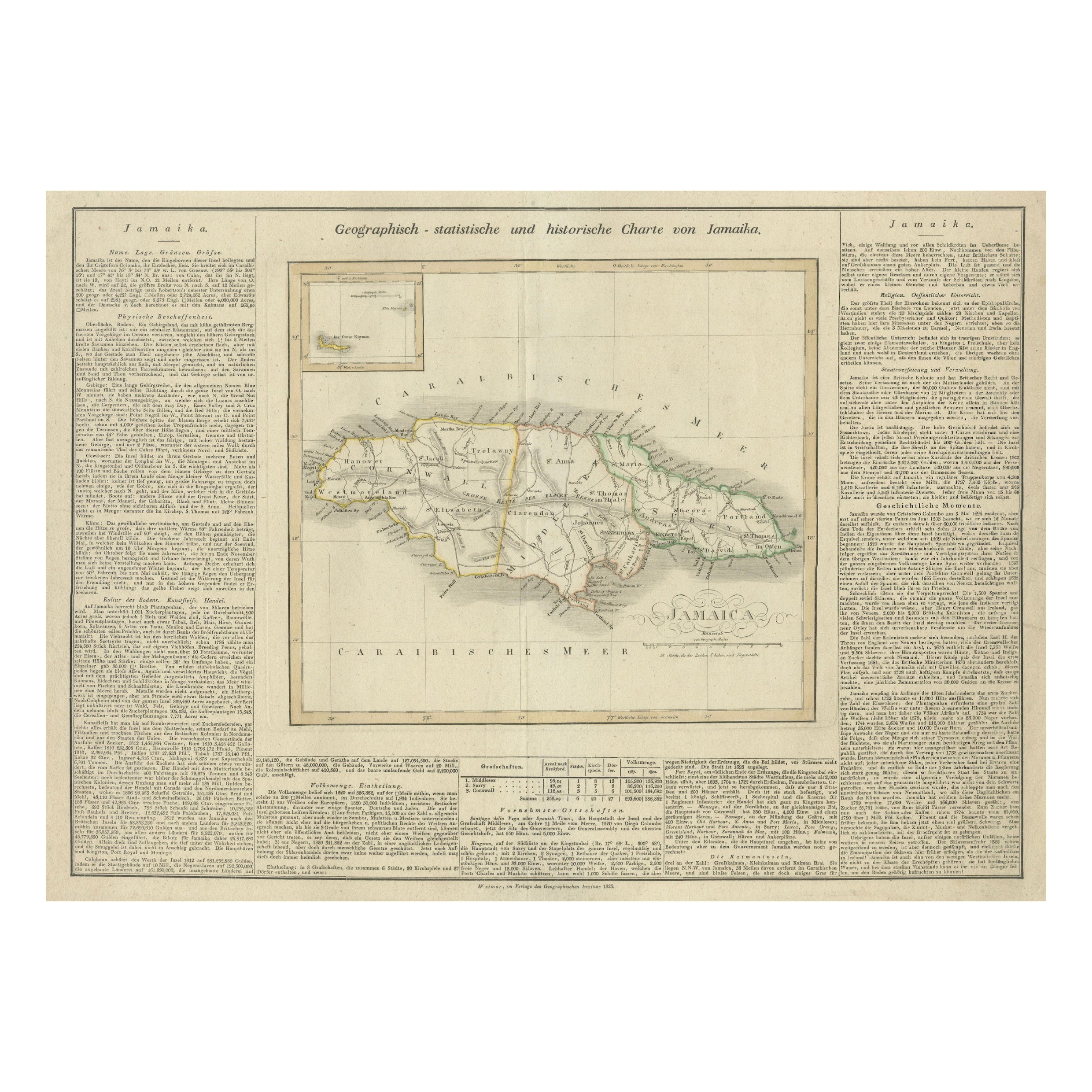
View AllDetailed Antique Map of Jamaica - Published in Weimar, 1825
Located in Langweer, NL
This map of Jamaica is an interesting historical document.
This map is part of an atlas that was issued in six editions in English, French, and German ...
Category
Antique 1820s Maps
Materials
Paper
$517 Sale Price
20% Off
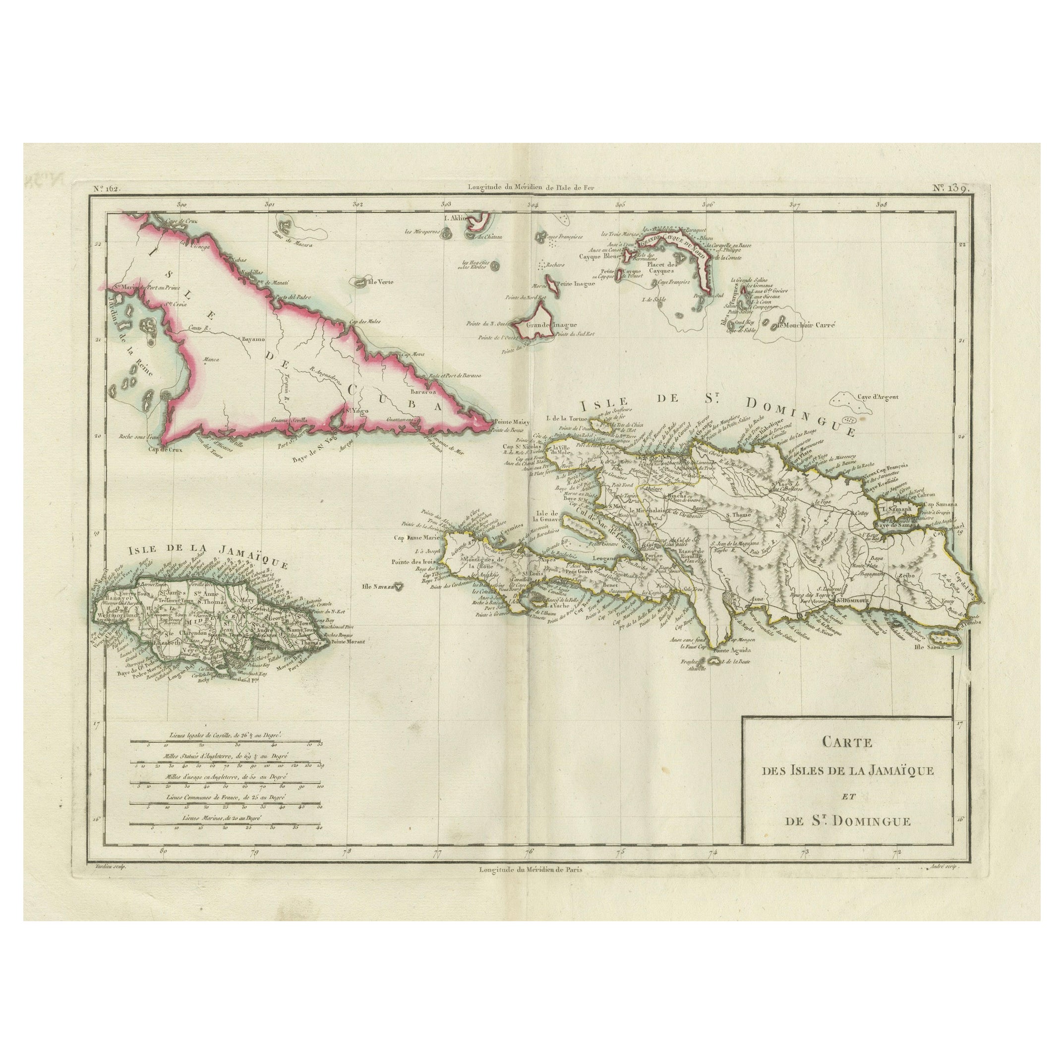
Antique Map of Jamaica and Hispaniola (Saint-Domingue and Santo Domingo), 1802
Located in Langweer, NL
This is an original antique map titled "Carte des Isles de la Jamaïque et de St. Domingue," depicting the islands of Jamaica and Saint-Domingue (modern-day Haiti and the Dominican Re...
Category
Antique Early 1800s Maps
Materials
Paper

$536 Sale Price
20% Off
Antique Map of the West Indies and Central America by W. G. Blackie, 1859
Located in Langweer, NL
Antique map titled 'The West India Island & Central America'. Original antique map of the West Indies and Central America, with inset map of Jamaica. Th...
Category
Antique Mid-19th Century Maps
Materials
Paper

$239 Sale Price
20% Off
Antique Map of the Antilles in the Caribbean, '1875'
Located in Langweer, NL
Antique map titled 'Carte des Iles Antilles'. Large map of the Antilles. This map originates from 'Atlas de Géographie Moderne Physique et Politique' by A. Levasseur. Published, 1875.
Category
Antique Late 19th Century Maps
Materials
Paper

$359 Sale Price
40% Off
Original Antique Map of the West Indies by J. Arrowsmith, 1842
Located in Langweer, NL
Title: "J. Arrowsmith's 19th Century Map of the West Indies"
This original antique map, crafted by J. Arrowsmith, details the West Indies with a focus on the Caribbean Sea and its s...
Category
Antique Early 19th Century Maps
Materials
Paper

Antique Map of the Antilles and Central America – 1872
Located in Langweer, NL
Title: Antique Map of the Antilles and Central America – 1872
Description:
This finely detailed antique map, titled Antilles et Amérique Centrale, was published in 1872 under t...
Category
Antique 1870s Maps
Materials
Paper

You May Also Like
Large Original Antique Map of The West Indies by Sidney Hall, 1847
Located in St Annes, Lancashire
Great map of The West Indies
Drawn and engraved by Sidney Hall
Steel engraving
Original colour outline
Published by A & C Black. 1847
Unframed
Free shipping.
Category
Antique 1840s Scottish Maps
Materials
Paper

Map Colonies Francaises Martinique, 1845
Located in BUNGAY, SUFFOLK
Colonies Francaises, Martinique, Amerique DU SUD
Geographie et Statistique par V.Levasseur. Ing'r Geographe.
Illustre par Raymond Bonheur, peintre.
Grave par Laguihermie, Rue St...
Category
Antique 19th Century French Maps
Materials
Paper

Original Antique Map of Central America / Florida, Arrowsmith, 1820
Located in St Annes, Lancashire
Great map of Central America.
Drawn under the direction of Arrowsmith.
Copper-plate engraving.
Published by Longman, Hurst, Rees, Orme and Brown, 1820
Unframed.
Category
Antique 1820s English Maps
Materials
Paper

St. Christophe 'St. Kitts' Island: An 18th Century Hand-colored Map by Bellin
By Jacques-Nicolas Bellin
Located in Alamo, CA
Jacques Bellin's copper-plate map of the Caribbean island of Saint Kitts entitled "Carte De De l'Isle St. Christophe Pour servir á l'Histoire Genle. des V...
Category
Antique Mid-18th Century French Maps
Materials
Paper

Puerto Rico 1910 Original Antique Map Of The Island In A Period Wood Frame
Located in Miami, FL
An antique framed map of Puerto Rico.
Very nice antique map of Puerto Rico printed in a folio of two pages. This map was printed in thin pa...
Category
Antique Early 1900s Puerto Rican American Classical Prints
Materials
Glass, Wood, Paper
$558 Sale Price
20% Off
Early 19th Century Hand Colored Map of the United States and Caribbean Islands
Located in Hamilton, Ontario
Hand coloured early 19th century map by Giraldon of France titled "Etats Unis et Grandes Antilles" (United States and Greater Antilles).
Category
Antique Early 19th Century French Maps
Materials
Paper

$595 Sale Price
40% Off
More Ways To Browse
Map Case
Flying Fish
Used Furniture Jamaica
Antique Plantation Furniture
Victorian Fish Set
Antique Map Case
Antique Bay Window
Taino Art
Antique Oushak Carpets
Blue Coffee Tables
1945 Chair Juhl
Antique Three Leg Table
Folke Arstrom
Silver Over Copper
Vintage Barware Glasses
Antique Etched Glass
Antique French Shell
Coffee Table Black Italian Modern