Items Similar to Paris and Surroundings – Antique Map by Gall and Inglis, Published 1843

Want more images or videos?
Request additional images or videos from the seller
1 of 10
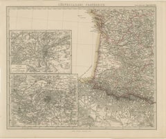
Paris and Surroundings – Antique Map by Gall and Inglis, Published 1843
$367.42per item
£273.54per item
€310per item
CA$506.25per item
A$563.71per item
CHF 298.10per item
MX$6,860.04per item
NOK 3,757.67per item
SEK 3,540.28per item
DKK 2,359.88per item
Quantity
About the Item
Antique Map of Paris and Environs by Gall and Inglis, 1843
This finely detailed map titled "Gall & Inglis’ Plan of Paris and Environs" was published in 1843 and provides a fascinating glimpse of mid-19th century Paris, just before the transformative urban renovations initiated by Baron Haussmann. Engraved with great precision and hand-colored to delineate the city’s administrative divisions, the map captures the dense, historic layout of central Paris before the sweeping modernization of boulevards, parks, and public buildings that would follow in the decades to come.
The map covers the full extent of the city as it was defined in the early 1840s, with major streets, landmarks, bridges, parks, and individual buildings clearly rendered. District boundaries are highlighted with original hand coloring, while the River Seine flows prominently through the heart of the city. Key sites such as the Louvre, Tuileries Gardens, Notre-Dame, the Panthéon, and the Champs-Élysées are labeled. Surrounding areas, including Montmartre, Passy, Chaillot, and Charonne, are shown in less detail but included in the city’s broader context.
Two inset maps provide additional context: one in the lower left shows the 'departments surrounding Paris', while another in the upper right offers a broader map of Paris and its surrounding region, giving insight into the city’s connections with major transport and postal routes.
The publisher, Gall and Inglis, was a respected Edinburgh and London-based firm active in the 19th century, known for producing atlases, maps, and guides with both educational and practical travel use. Their Paris plan combines both cartographic accuracy and aesthetic appeal, with a clean yet elegant decorative border framing the composition.
Condition:
The map is in fair condition for its age. Original folds are present, and there is minor toning and wear along the edges, including a small tear in the upper right margin that does not affect the printed area. Light foxing is visible in some places, mostly confined to the margins. The hand coloring remains clear and attractive, with no loss of detail.
Framing suggestion:
This map would be ideally presented in a slim, black or dark walnut wood frame, with a neutral or light ivory archival mat. A slightly larger mat border will help showcase the decorative outer frame of the map. UV-protective glass is recommended to preserve both the colors and paper from further age-related wear. This is an excellent historical piece for lovers of Paris, 19th-century urban history, or antique cartography.
- Dimensions:Height: 16.93 in (43 cm)Width: 22.05 in (56 cm)Depth: 0.01 in (0.2 mm)
- Materials and Techniques:
- Place of Origin:
- Period:
- Date of Manufacture:1843
- Condition:The map is in fair condition for its age. Original folds are present, and there is minor toning and wear along the edges, including a small tear in the upper right margin that does not affect the printed area. Light foxing is visible in some places.
- Seller Location:Langweer, NL
- Reference Number:Seller: BG-13757-101stDibs: LU3054345617142
About the Seller
5.0
Recognized Seller
These prestigious sellers are industry leaders and represent the highest echelon for item quality and design.
Platinum Seller
Premium sellers with a 4.7+ rating and 24-hour response times
Established in 2009
1stDibs seller since 2017
2,567 sales on 1stDibs
Typical response time: <1 hour
- ShippingRetrieving quote...Shipping from: Langweer, Netherlands
- Return Policy
Authenticity Guarantee
In the unlikely event there’s an issue with an item’s authenticity, contact us within 1 year for a full refund. DetailsMoney-Back Guarantee
If your item is not as described, is damaged in transit, or does not arrive, contact us within 7 days for a full refund. Details24-Hour Cancellation
You have a 24-hour grace period in which to reconsider your purchase, with no questions asked.Vetted Professional Sellers
Our world-class sellers must adhere to strict standards for service and quality, maintaining the integrity of our listings.Price-Match Guarantee
If you find that a seller listed the same item for a lower price elsewhere, we’ll match it.Trusted Global Delivery
Our best-in-class carrier network provides specialized shipping options worldwide, including custom delivery.More From This Seller
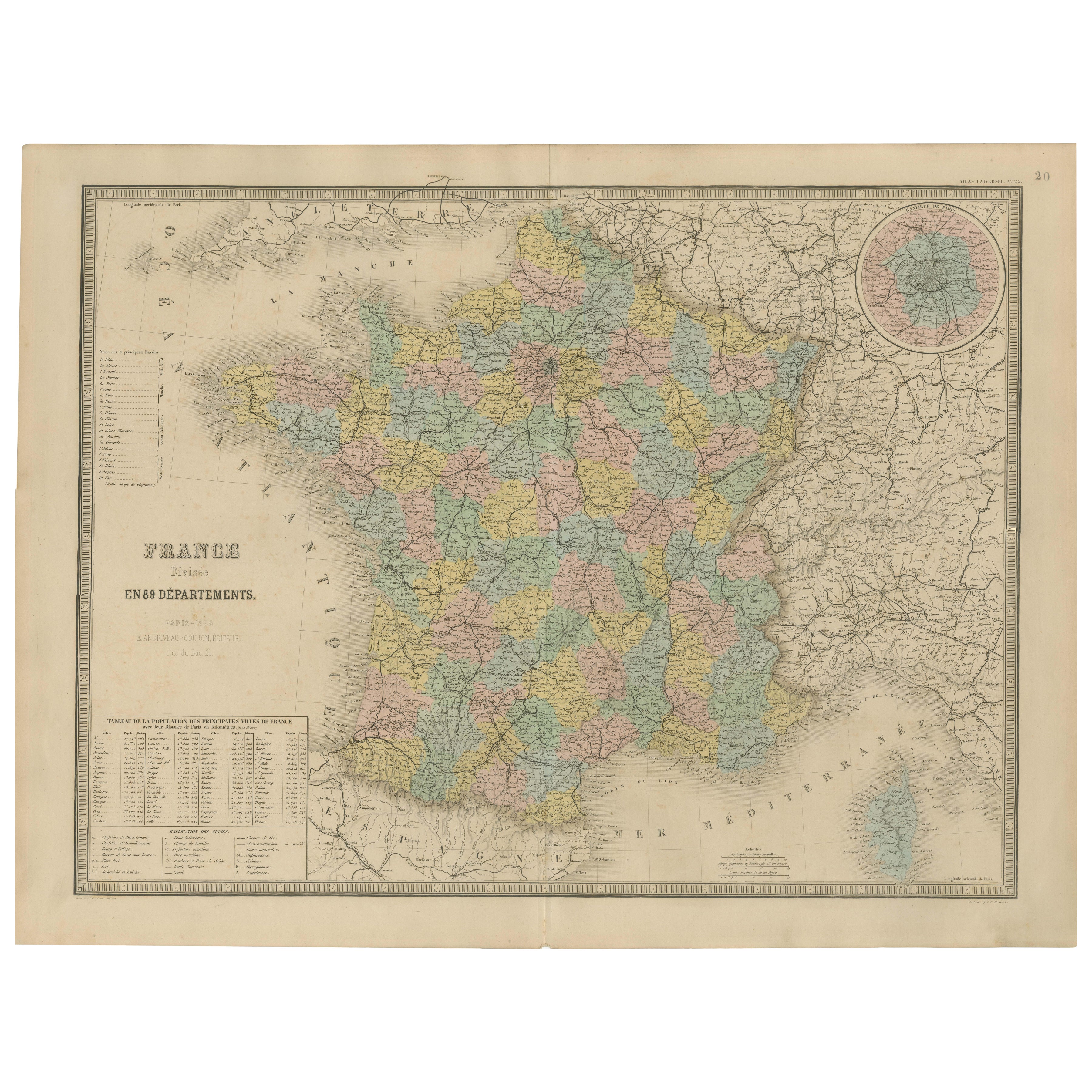
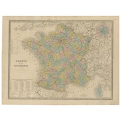
View AllAntique Map of France – Divided into 89 Departments by Andriveau-Goujon, 1861
Located in Langweer, NL
Antique Map of France – Divided into 89 Departments by Andriveau-Goujon, 1861
This finely engraved and beautifully hand-colored map titled “France divisée en 89 Départements” was pu...
Category
Antique Mid-19th Century French Maps
Materials
Paper
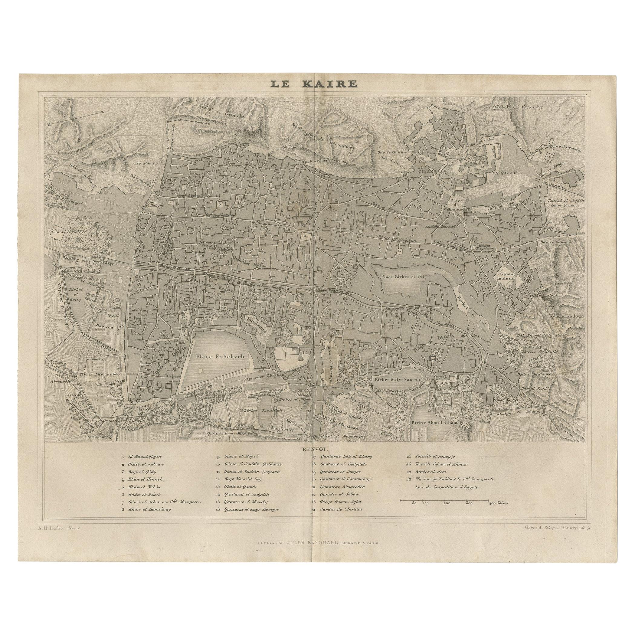
Antique Map of Cairo and Surroundings by Balbi '1847'
Located in Langweer, NL
Antique map titled 'Le Kaire'. Original antique map of Cairo and surroundings, Egypt. This map originates from 'Abrégé de Géographie (..)' by Adrien Balbi. Published 1847.
Category
Antique Mid-19th Century Maps
Materials
Paper
$142 Sale Price
20% Off
Antique Map of the City of Berlin in Germany, '1847'
Located in Langweer, NL
Antique map titled 'Berlin'. Original antique map of the city of Berlin, Germany. This map originates from 'Abrégé de Géographie (..)' by Adrien Balbi. Published 1847.
Category
Antique Mid-19th Century Maps
Materials
Paper

$142 Sale Price
20% Off
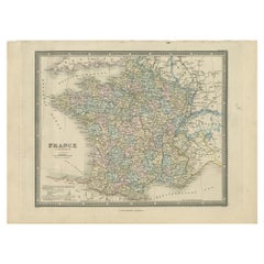
Antique Map of France by Balbi '1847'
Located in Langweer, NL
Antique map titled 'France'. Original antique map of France. This map originates from 'Abrégé de Géographie (..)' by Adrien Balbi. Published 1847.
Category
Antique Mid-19th Century Maps
Materials
Paper

$118 Sale Price
20% Off
Antique Map of France in Departments by Wyld '1845'
Located in Langweer, NL
Antique map titled 'France in Departments'. Original antique map of France. This map originates from 'An Atlas of the World, Comprehending Separate Maps of its...
Category
Antique Mid-19th Century Maps
Materials
Paper
$189 Sale Price
20% Off
Antique Map of Southwestern France – With Insets of Paris & Lyon, 1858
Located in Langweer, NL
Antique Map of Southwestern France – With Insets of Paris & Lyon, 1858
Detailed copperplate map of "Südwestliches Frankreich" (Southwestern France), created by Friedrich von Stülpna...
Category
Antique Mid-19th Century German Maps
Materials
Paper
You May Also Like
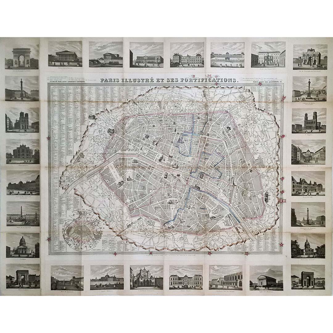
1851 Original map by Maillard - Plan de Paris et ses Fortifications
Located in PARIS, FR
In the world of cartography, maps transcend mere geography; they are historical records and works of art, encapsulating the essence of a place at a specific moment in time. The 1851 ...
Category
1850s Prints and Multiples
Materials
Paper, Lithograph, Linen

Paris, France. Antique Map City Plan Chromolithograph, circa 1895
Located in Melbourne, Victoria
'Paris'
Colour lithograph. 1895.
250mm by 305mm (sheet).
Late 19th century German lithograph plan of Paris, France.
Central vertical fold. Printed street index on the reverse o...
Category
Late 19th Century Victorian More Prints
Materials
Lithograph
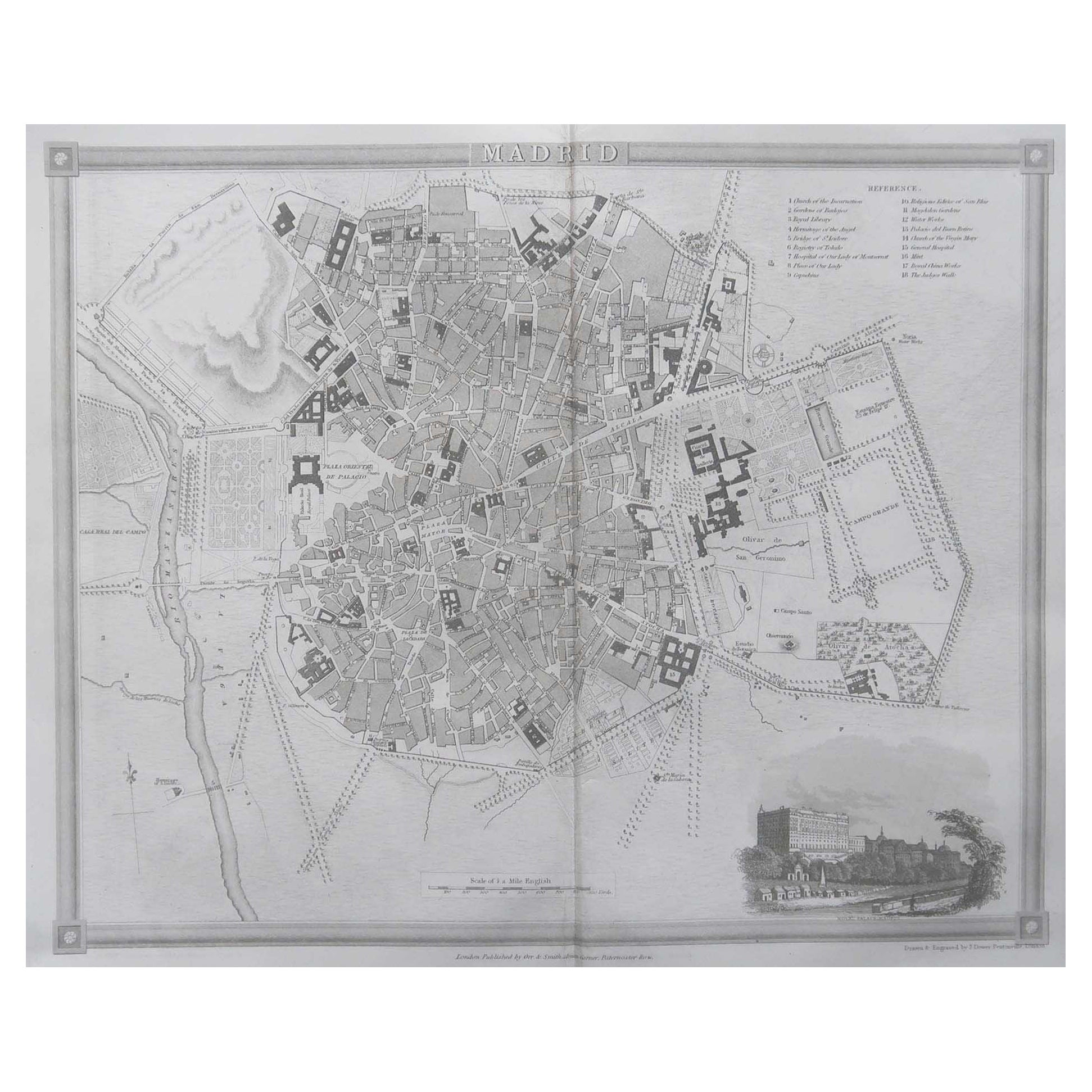
Original Antique Map or City Plan of Madrid, Spain. Circa 1835
Located in St Annes, Lancashire
Nice map of Madrid
Drawn and engraved by J.Dower
Published by Orr & Smith. C.1835
Unframed.
Free shipping
Category
Antique 1830s English Maps
Materials
Paper

Original Large Antique Map of Paris, France by John Dower, 1861
Located in St Annes, Lancashire
Fabulous monochrome map of Paris.
Vignettes of St Germain En Laye, Saint Cloud, Versailles and Fontainbleau.
Unframed.
Drawn by J.Dower.
Lithography by Weller. 4 sheets joined to...
Category
Antique 1860s English Victorian Maps
Materials
Paper

Original Antique Map or City Plan of Rome, Italy. Circa 1835
Located in St Annes, Lancashire
Nice map of Rome
Drawn and engraved by J.Dower
Published by Orr & Smith. C.1835
Unframed.
Free shipping
Category
Antique 1830s English Maps
Materials
Paper

1848 Original map by Maillard - Plan de Paris et ses Fortifications
Located in PARIS, FR
In the realm of cartography, maps serve as both practical tools and artistic representations, encapsulating the essence of a place at a specific moment in time. The 1848 vintage map,...
Category
1840s Prints and Multiples
Materials
Paper, Linen, Lithograph
More Ways To Browse
Antique Keys London
Antique Street Light
Antique Ivory Collectables
Garden Bridge
Antique Key Heart
Antique Postal Furniture
Styles Of Antique Desks
Black And White Coffee Table
Curved Velvet Couch
Velvet Curved Sofa
Wood Round Coffee Tables
Antique Paper Flowers
Oak Brutalist
Used College Furniture
Wood Minimalist Chair
2002 Lamp
Antique Imperial Furniture
Gold Modern Coffee Table