


Want more images or videos?
Request additional images or videos from the seller
1 of 5
Antique Map of France by Balbi '1847'
About the Item
Antique map titled 'France'. Original antique map of France. This map originates from 'Abrégé de Géographie (..)' by Adrien Balbi. Published 1847.
- Dimensions:Height: 9.06 in (23 cm)Width: 11.23 in (28.5 cm)Depth: 0.02 in (0.5 mm)
- Materials and Techniques:
- Period:
- Date of Manufacture:1847
- Condition:General age-related toning, some staining. Original folding line. Minor wear, blank verso. Please study image carefully.
- Seller Location:Langweer, NL
- Reference Number:
About the Seller
5.0
Platinum Seller
These expertly vetted sellers are 1stDibs' most experienced sellers and are rated highest by our customers.
Established in 2009
1stDibs seller since 2017
1,916 sales on 1stDibs
Typical response time: <1 hour
- ShippingRetrieving quote...Ships From: Langweer, Netherlands
- Return PolicyA return for this item may be initiated within 14 days of delivery.
More From This SellerView All
- Antique Map of Oceania by Balbi '1847'Located in Langweer, NLAntique map titled 'Océanie'. Original antique map of Oceania. This map originates from 'Abrégé de Géographie (..)' by Adrien Balbi. Published 1847.Category
Antique Mid-19th Century Maps
MaterialsPaper
- Antique Map of Europe by Balbi '1847'Located in Langweer, NLAntique map titled 'Europe'. Original antique map of Europe. This map originates from 'Abrégé de Géographie (..)' by Adrien Balbi. Published 1847.Category
Antique Mid-19th Century Maps
MaterialsPaper
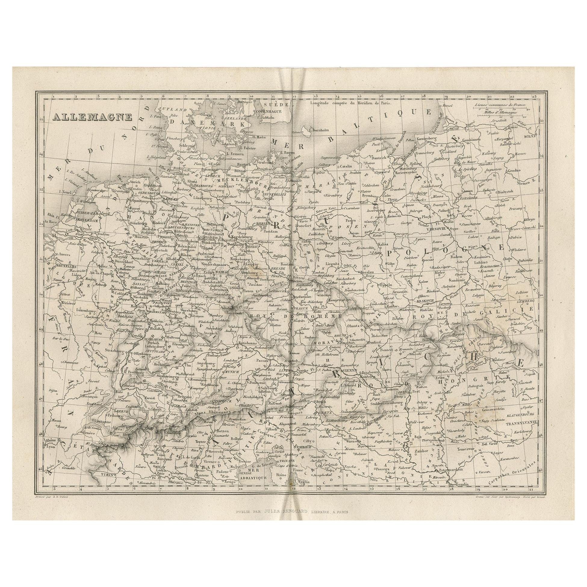
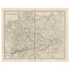
- Antique Map of Germany by Balbi '1847'Located in Langweer, NLAntique map titled 'Allemagne'. Original antique map of Germany. This map originates from 'Abrégé de Géographie (..)' by Adrien Balbi. Published...Category
Antique Mid-19th Century Maps
MaterialsPaper
- Antique Map of Asia by Balbi '1847'Located in Langweer, NLAntique map titled 'Asie'. Original antique map of Asia. This map originates from 'Abrégé de Géographie (..)' by Adrien Balbi. Published 1847.Category
Antique Mid-19th Century Maps
MaterialsPaper
- Antique Map of the World by Balbi '1847'Located in Langweer, NLAntique map titled 'Planisphère'. Original antique map of the world. This map originates from 'Abrégé de Géographie (..)' by Adrien Balbi. Pub...Category
Antique Mid-19th Century Maps
MaterialsPaper
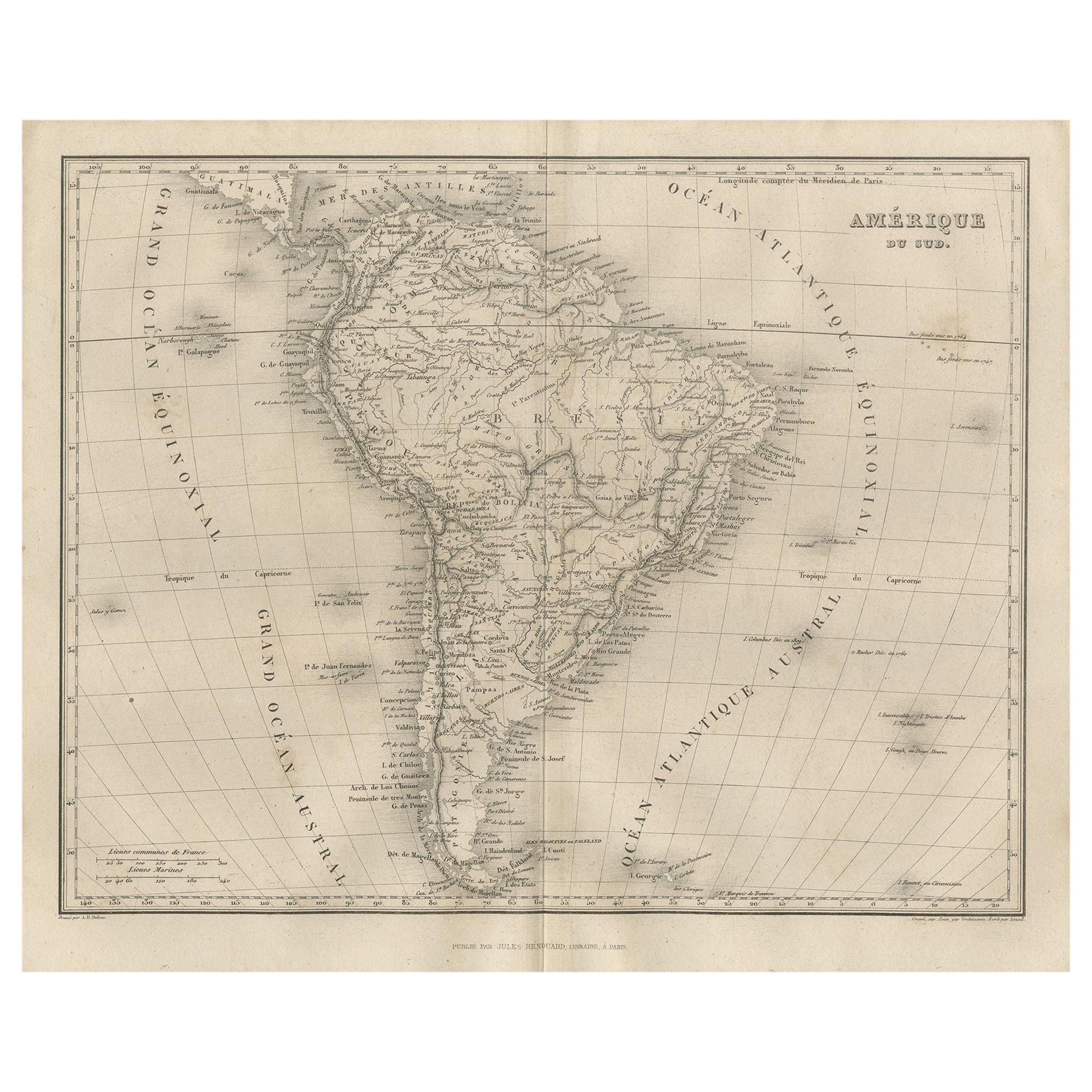
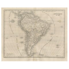
- Antique Map of South America by Balbi '1847'Located in Langweer, NLAntique map titled 'Amérique du sud'. Original antique map of South America. This map originates from 'Abrégé de Géographie (..)' by Adrie...Category
Antique Mid-19th Century Maps
MaterialsPaper


You May Also Like
- Original Antique Map of France, Arrowsmith, 1820Located in St Annes, LancashireGreat map of France Drawn under the direction of Arrowsmith. Copper-plate engraving. Published by Longman, Hurst, Rees, Orme and Brown, 1820 Unframed.Category
Antique 1820s English Maps
MaterialsPaper
- Antique Map of Italy by Andriveau-Goujon, 1843By Andriveau-GoujonLocated in New York, NYAntique Map of Italy by Andriveau-Goujon, 1843. Map of Italy in two parts by Andriveau-Goujon for the Library of Prince Carini at Palazzo Carini i...Category
Antique 1840s French Maps
MaterialsLinen, Paper
- Antique Map of Principality of MonacoBy Antonio Vallardi EditoreLocated in Alessandria, PiemonteST/619 - "Old Geographical Atlas of Italy - Topographic map of ex-Principality of Monaco" - ediz Vallardi - Milano - A somewhat special edition ---Category
Antique Late 19th Century Italian Other Prints
MaterialsPaper
- Original Antique Map of Russia By Arrowsmith. 1820Located in St Annes, LancashireGreat map of Russia Drawn under the direction of Arrowsmith Copper-plate engraving Published by Longman, Hurst, Rees, Orme and Brown, 1820 Unframed.Category
Antique 1820s English Maps
MaterialsPaper
- Original Antique Map of France, Sherwood, Neely & Jones, Dated 1809Located in St Annes, LancashireGreat map of France Copper-plate engraving by Cooper Published by Sherwood, Neely & Jones. Dated 1809 Unframed.Category
Antique Early 1800s English Maps
MaterialsPaper
- Original Antique Map of China by Thomas Clerk, 1817Located in St Annes, LancashireGreat map of China Copper-plate engraving Drawn and engraved by Thomas Clerk, Edinburgh. Published by Mackenzie And Dent, 1817 Unframed.Category
Antique 1810s English Maps
MaterialsPaper


