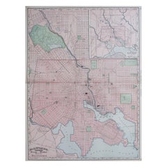
Items Similar to Plan of Baltimore City Map, USA c.1870 – Hand-Colored Street Plan
Want more images or videos?
Request additional images or videos from the seller
1 of 10
Plan of Baltimore City Map, USA c.1870 – Hand-Colored Street Plan
$377.16
£284.08
€320
CA$520.12
A$584.33
CHF 305.31
MX$7,132.02
NOK 3,876.59
SEK 3,648.99
DKK 2,435.72
About the Item
Plan of Baltimore City Map, USA c.1870 – Hand-Colored Street Plan
This is a finely engraved and hand-colored street plan titled Plan of Baltimore, published in the United States circa 1870. It shows the city of Baltimore, Maryland, in detailed block layout with wards numbered and shaded in pastel pink, green, yellow, and blue wash colors.
The map displays streets, rail lines, cemeteries including Green Mount Cemetery and Baltimore Cemetery, the Middle Branch and Northwest Branch of the Patapsco River, docks, major buildings, and urban features. A fine floral decorative border surrounds the map, typical of American atlas city plans from the mid to late 19th century.
This city plan is highly detailed, reflecting Baltimore's urban expansion during the post-Civil War era as it grew into a major port, industrial, and cultural center on the US East Coast. Such city plans were included in county and state atlases or urban directories for reference, property planning, and civic promotion.
Condition report:
Good condition. Strong impression with bright original hand coloring. Light general age toning and minor marginal handling marks, with a faint stain at the bottom margin outside the printed area. No tears or repairs visible. Wide margins and plate mark intact.
Framing suggestion:
Frame with a simple black or dark wood frame and an archival off-white mat to highlight the pastel coloring and intricate decorative floral border. UV-protective glass is recommended to preserve paper quality and prevent fading.
- Dimensions:Height: 12.29 in (31.2 cm)Width: 15.36 in (39 cm)Depth: 0.01 in (0.2 mm)
- Materials and Techniques:
- Place of Origin:
- Period:
- Date of Manufacture:circa 1870
- Condition:Good condition. Strong impression with bright original hand coloring. Light general age toning and minor marginal handling marks, with a faint stain at the bottom margin outside the printed area. No tears or repairs visible. Wide margins.
- Seller Location:Langweer, NL
- Reference Number:Seller: BG-13952-311stDibs: LU3054345730092
About the Seller
5.0
Recognized Seller
These prestigious sellers are industry leaders and represent the highest echelon for item quality and design.
Platinum Seller
Premium sellers with a 4.7+ rating and 24-hour response times
Established in 2009
1stDibs seller since 2017
2,534 sales on 1stDibs
Typical response time: <1 hour
- ShippingRetrieving quote...Shipping from: Langweer, Netherlands
- Return Policy
Authenticity Guarantee
In the unlikely event there’s an issue with an item’s authenticity, contact us within 1 year for a full refund. DetailsMoney-Back Guarantee
If your item is not as described, is damaged in transit, or does not arrive, contact us within 7 days for a full refund. Details24-Hour Cancellation
You have a 24-hour grace period in which to reconsider your purchase, with no questions asked.Vetted Professional Sellers
Our world-class sellers must adhere to strict standards for service and quality, maintaining the integrity of our listings.Price-Match Guarantee
If you find that a seller listed the same item for a lower price elsewhere, we’ll match it.Trusted Global Delivery
Our best-in-class carrier network provides specialized shipping options worldwide, including custom delivery.More From This Seller
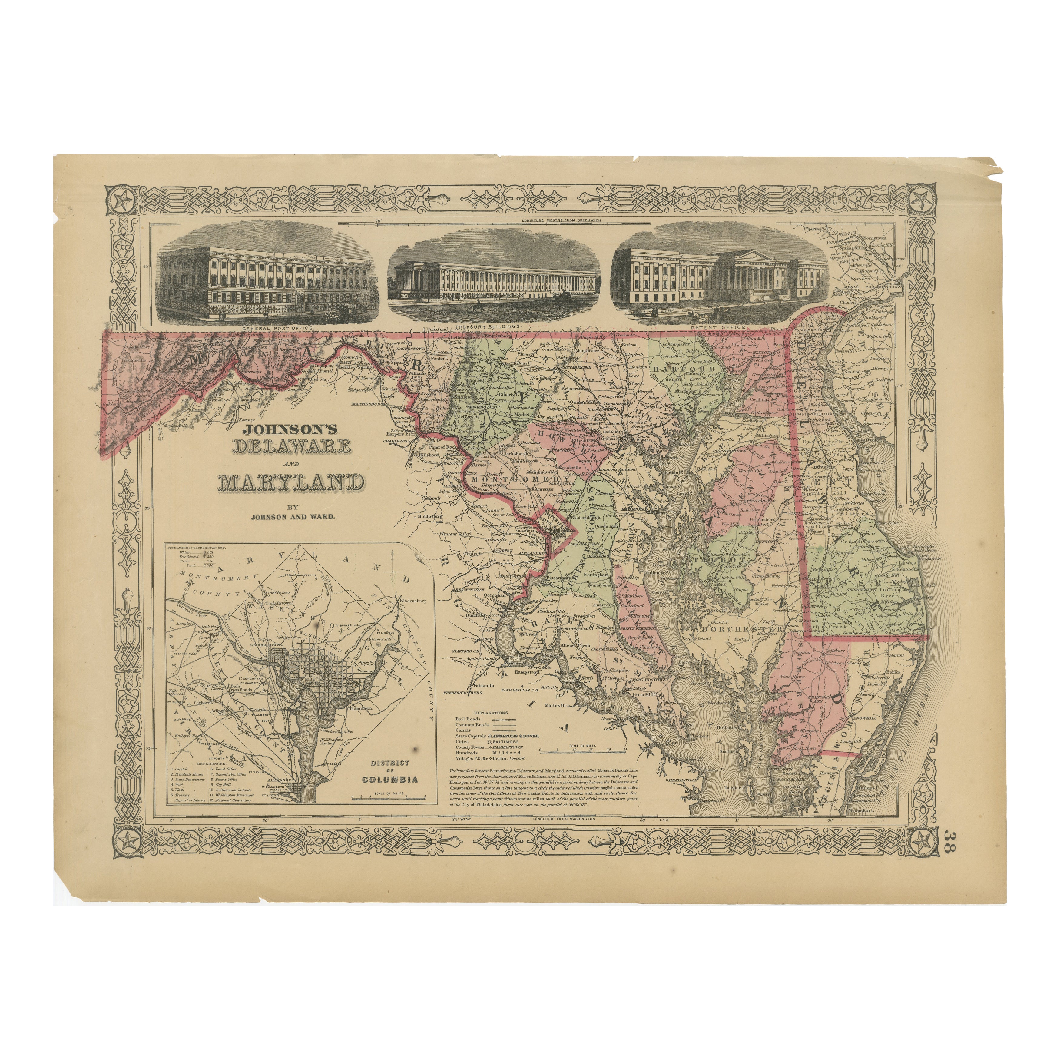
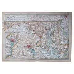
View AllDelaware and Maryland Map – Johnson, Hand-Colored with Insets, 1864
Located in Langweer, NL
Johnson’s Delaware and Maryland Map, USA c.1864 – Hand-Colored with Insets
This is a finely engraved and hand-colored map titled Johnson’s Delaware and Maryland, published by Johnso...
Category
Antique Mid-19th Century American Maps
Materials
Paper
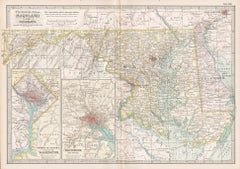
1864 Johnson's Map of Virginia, Delaware, and Maryland with Fort Monroe Inset
Located in Langweer, NL
Title: 1864 Johnson's Map of Virginia, Delaware, and Maryland with Fort Monroe Inset
Description: This 1864 map titled "Johnson's Virginia, Delaware, and ...
Category
Antique 1860s Maps
Materials
Paper
$282 Sale Price
20% Off
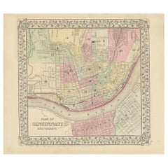
Plan of Cincinnati Map, USA c.1870 – Hand-Colored Street Plan with Wards
Located in Langweer, NL
Plan of Cincinnati Map, USA c.1870 – Hand-Colored Street Plan with Wards
This is a finely engraved and hand-colored street plan titled Plan of Cincinnati and Vicinity, published in ...
Category
Antique Mid-19th Century American Maps
Materials
Paper
Antique Map of St. Louis and Chicago
Located in Langweer, NL
Antique map titled 'The City of St. Louis Missouri - The City of Chicago Illinois'. Dual map on single page showing St. Louis and Chicago. Finely produ...
Category
Antique Mid-19th Century Maps
Materials
Paper

$141 Sale Price
20% Off
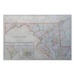
Antique Map of New Jersey, Delaware and Maryland by Johnson, 1872
Located in Langweer, NL
Antique map titled 'Johnson's New Jersey (..). Two maps on one sheet showing New Jersey, Delaware and Maryland. With inset map of the district of Columbia...
Category
Antique Late 19th Century Maps
Materials
Paper
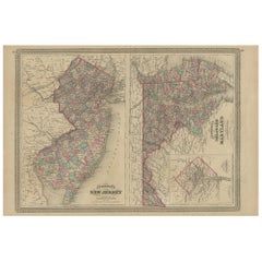
$282 Sale Price
20% Off
Antique Map of West Alexandria, Manchester & Enterprise, 1871
Located in Langweer, NL
Antique map titled 'West Alexandria, Manchester, Enterprise'. Original antique map of villages and communities of Ohio. This map originates from 'Atlas of Preble County Ohio' by C.O....
Category
Antique Late 19th Century Maps
Materials
Paper
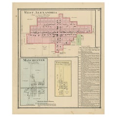
$235 Sale Price
20% Off
You May Also Like
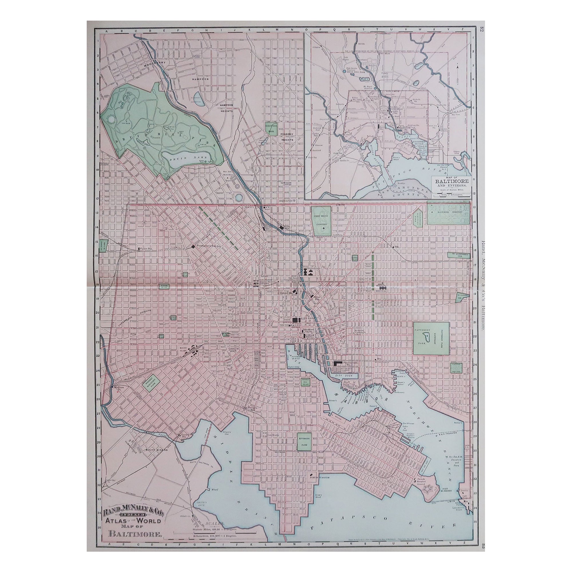
Large Original Antique City Plan of Baltimore, USA, 1894
By Rand McNally & Co.
Located in St Annes, Lancashire
Fabulous colorful map of Baltimore
Original color
By Rand, McNally & Co.
Published, 1894
Unframed
Free shipping.
Category
Antique 1890s American Maps
Materials
Paper
Original Antique Map of the American State of Maryland & Delaware, 1903
Located in St Annes, Lancashire
Antique map of Maryland And Delaware
Published By A & C Black. 1903
Original colour
Good condition
Unframed.
Free shipping
Category
Antique Early 1900s English Maps
Materials
Paper
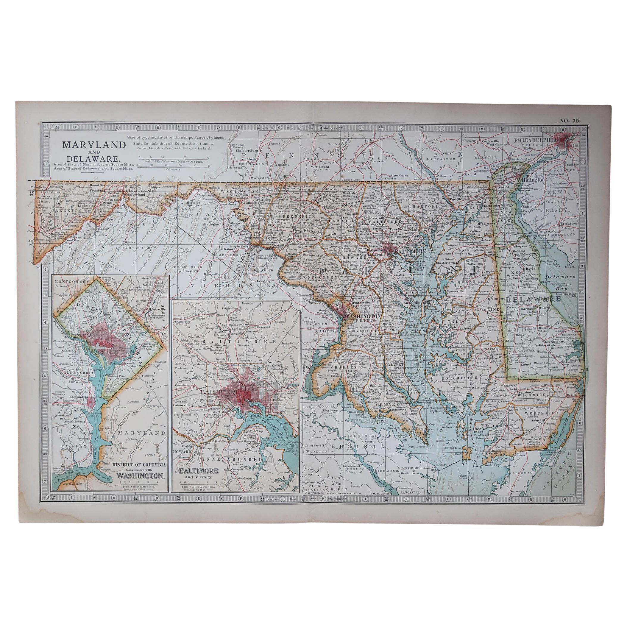
Large Original Antique Map of Maryland, Delaware & DC, USA, C.1900
Located in St Annes, Lancashire
Fabulous map of Maryland, Delaware And District of Columbia
Original color
Engraved and printed by the George F. Cram Company, Indianapolis.
Pu...
Category
Antique 1890s American Maps
Materials
Paper
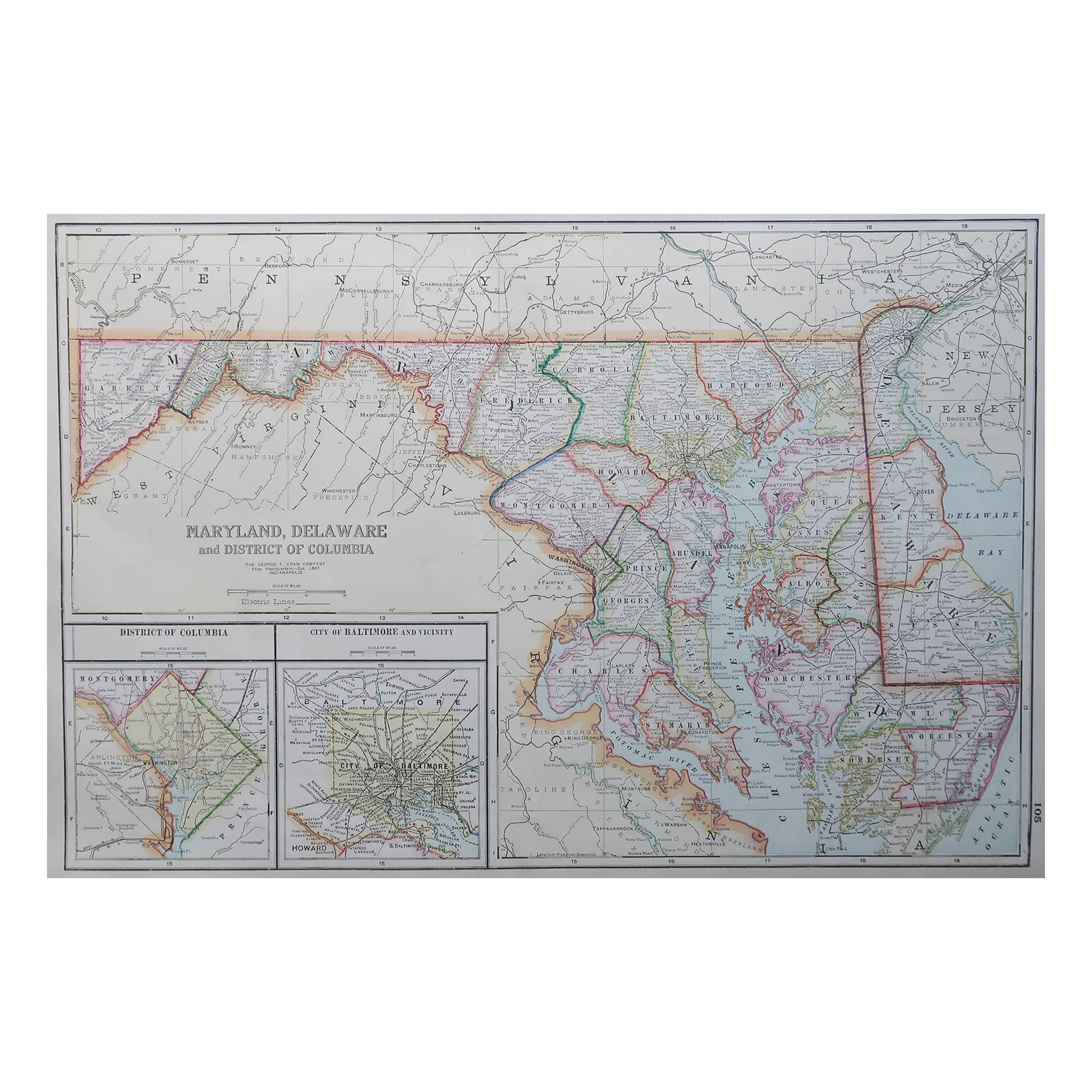
Maryland and Delaware. USA. Century Atlas state antique vintage map
Located in Melbourne, Victoria
'The Century Atlas. Maryland and Delaware.'
Original antique map, 1903.
Central fold as issued. Map name and number printed on the reverse corners.
Sheet 29.5cm by 40cm.
Category
Early 20th Century Victorian More Prints
Materials
Lithograph
Large Original Antique City Plan of Philadelphia, USA, circa 1900
By Rand McNally & Co.
Located in St Annes, Lancashire
Fabulous colorful map of Philadelphia
Original color
By Rand, McNally & Co.
Published, circa 1900.
Unframed
Free shipping.
Category
Antique Early 1900s American Maps
Materials
Paper

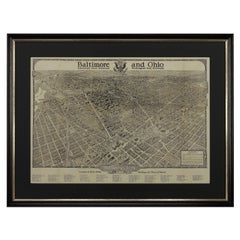
1923 "Washington, The Beautiful Capital of the Nation" Baltimore and Ohio RR Map
Located in Colorado Springs, CO
This is a fabulous 1923 bird's eye map of Washington, DC that shows the city in amazing detail. Every building is individually drawn and all major roads in the city are shown. The vi...
Category
Vintage 1920s American Art Deco Maps
Materials
Paper
More Ways To Browse
Antique Street Light
Baltimore Antique Furniture
Antique Furniture Directory
Post And Rail Furniture
Curved Velvet Couch
Velvet Curved Sofa
Wood Round Coffee Tables
Oak Brutalist
Used College Furniture
Wood Minimalist Chair
Antique Imperial Furniture
Gold Modern Coffee Table
Large Side Tables
18th Century Gilded Furniture
Fluted Column
Japanese Silver Ceramics
One Of A Kind Chair
Used Oak Dining Room Chairs