Items Similar to Rare and Interesting Small Antique Woodcut Map of the Mediterranean, 1568

Want more images or videos?
Request additional images or videos from the seller
1 of 6
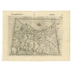
Rare and Interesting Small Antique Woodcut Map of the Mediterranean, 1568
$2,502.64
$3,336.8525% Off
£1,853.40
£2,471.2025% Off
€2,100
€2,80025% Off
CA$3,447.93
CA$4,597.2325% Off
A$3,833.49
A$5,111.3325% Off
CHF 2,018.57
CHF 2,691.4225% Off
MX$46,511.82
MX$62,015.7725% Off
NOK 25,556.05
NOK 34,074.7425% Off
SEK 23,888.68
SEK 31,851.5725% Off
DKK 15,984.85
DKK 21,313.1325% Off
About the Item
Very rare untitled antique woodcut map showing the region of the missionary journeys of Apostle Paul. It shows the Mediterranean with Greece, Asia Minor (Turkey), Northern Africa, Southern Italy and surroundings. With small legend including six islands (Samos and others). With descriptive text below the map.
This map originates from 'The Bishop's Bible' published in 1568. The Bishops' Bible is an English edition of the Bible which was produced under the authority of the established Church of England in 1568. It was substantially revised in 1572, and the 1602 edition was prescribed as the base text for the King James Version that was completed in 1611.
- Dimensions:Height: 5.63 in (14.3 cm)Width: 6.78 in (17.2 cm)Depth: 0.02 in (0.5 mm)
- Materials and Techniques:
- Period:
- Date of Manufacture:1568
- Condition:Image trimmed. General age-related toning. Minor wear. English text on verso. Please study image carefully.
- Seller Location:Langweer, NL
- Reference Number:Seller: BG-13449-61stDibs: LU3054335526292
About the Seller
5.0
Recognized Seller
These prestigious sellers are industry leaders and represent the highest echelon for item quality and design.
Platinum Seller
Premium sellers with a 4.7+ rating and 24-hour response times
Established in 2009
1stDibs seller since 2017
2,569 sales on 1stDibs
Typical response time: <1 hour
- ShippingRetrieving quote...Shipping from: Langweer, Netherlands
- Return Policy
Authenticity Guarantee
In the unlikely event there’s an issue with an item’s authenticity, contact us within 1 year for a full refund. DetailsMoney-Back Guarantee
If your item is not as described, is damaged in transit, or does not arrive, contact us within 7 days for a full refund. Details24-Hour Cancellation
You have a 24-hour grace period in which to reconsider your purchase, with no questions asked.Vetted Professional Sellers
Our world-class sellers must adhere to strict standards for service and quality, maintaining the integrity of our listings.Price-Match Guarantee
If you find that a seller listed the same item for a lower price elsewhere, we’ll match it.Trusted Global Delivery
Our best-in-class carrier network provides specialized shipping options worldwide, including custom delivery.More From This Seller
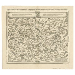
View AllEarly Woodcut Map of Franconia and Surrounding Regions, 1628
Located in Langweer, NL
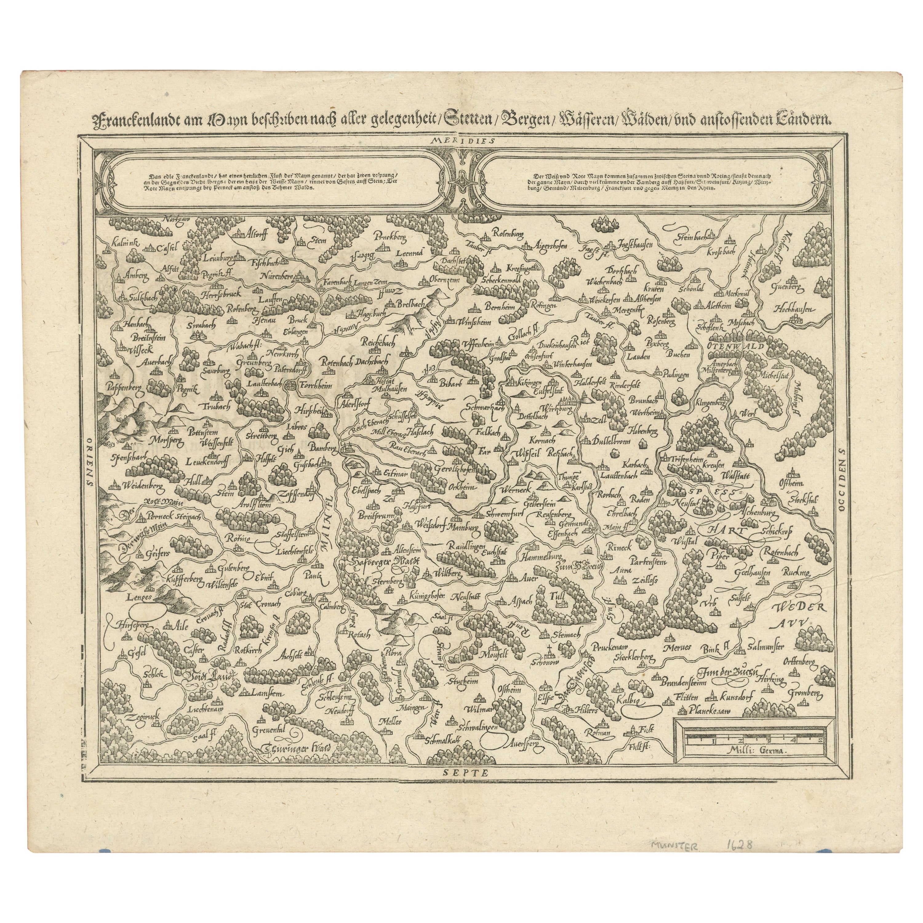
Title: Early Woodcut Map of Franconia and Surrounding Regions, 1628
Franconia (Franckenlande) is a region in Germany. Historically, Franconia was a significant part of the Holy Roma...
Category
Antique 1620s Maps
Materials
Paper
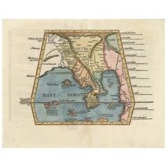
Map of India and Southeast Asia from Ptolemaic Geography – 16th Century Woodcut
Located in Langweer, NL
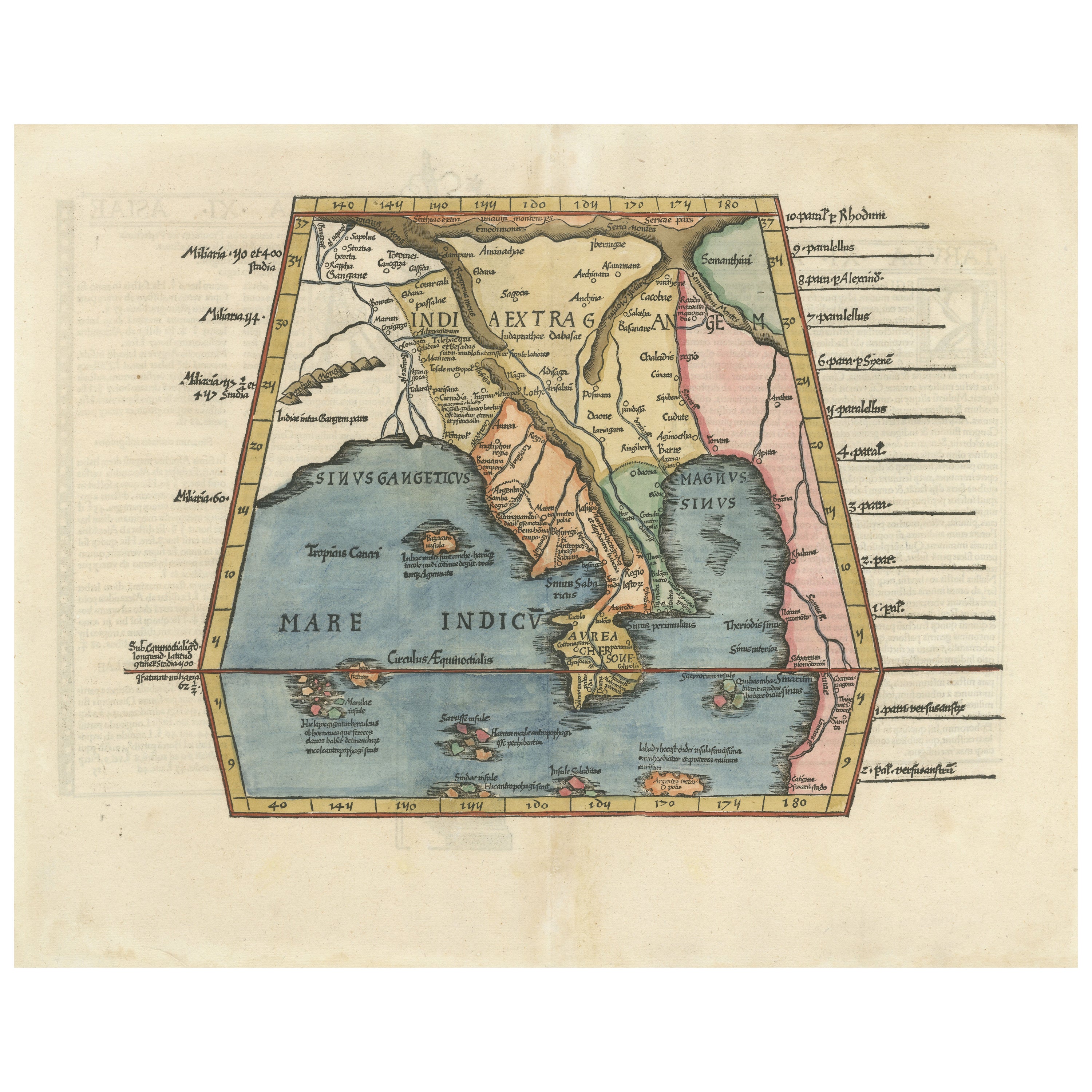
Map of India and Southeast Asia from Ptolemaic Geography – 16th Century Woodcut
This remarkable hand-colored woodcut map, originally designed according to the geographical knowledge...
Category
Antique 16th Century European Maps
Materials
Paper
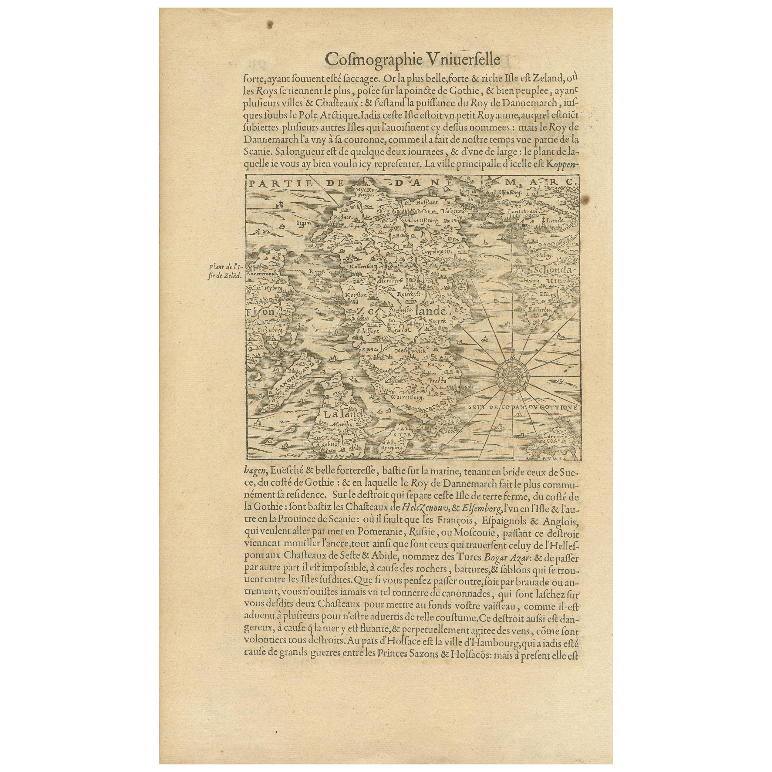
Antique Map of the Island of Zealand 'Denmark' by Thevet, circa 1590
Located in Langweer, NL
Antique map titled 'Partie de Danemarc'. Map of the island of Zealand, Denmark, including the city of Copenhagen. This map originates from 'Cosmographie Universelle' by André Thevet.
Category
Antique 16th Century Maps
Materials
Paper
$262 Sale Price
20% Off
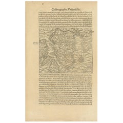
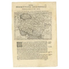
Old Ptolemaic Map of the Region Between the Persian Gulf and Caspian Sea, 1598
Located in Langweer, NL
"Tabula Asiae V", Ptolemy/Ruscelli
Subject: Persia - Iran
Period: 1598 (published)
Publication: Geografia di Claudio Tolomeo Allessadrino…
Claudius Ptolemy was a mathematician, ast...
Category
Antique 16th Century Maps
Materials
Paper
$381 Sale Price
20% Off
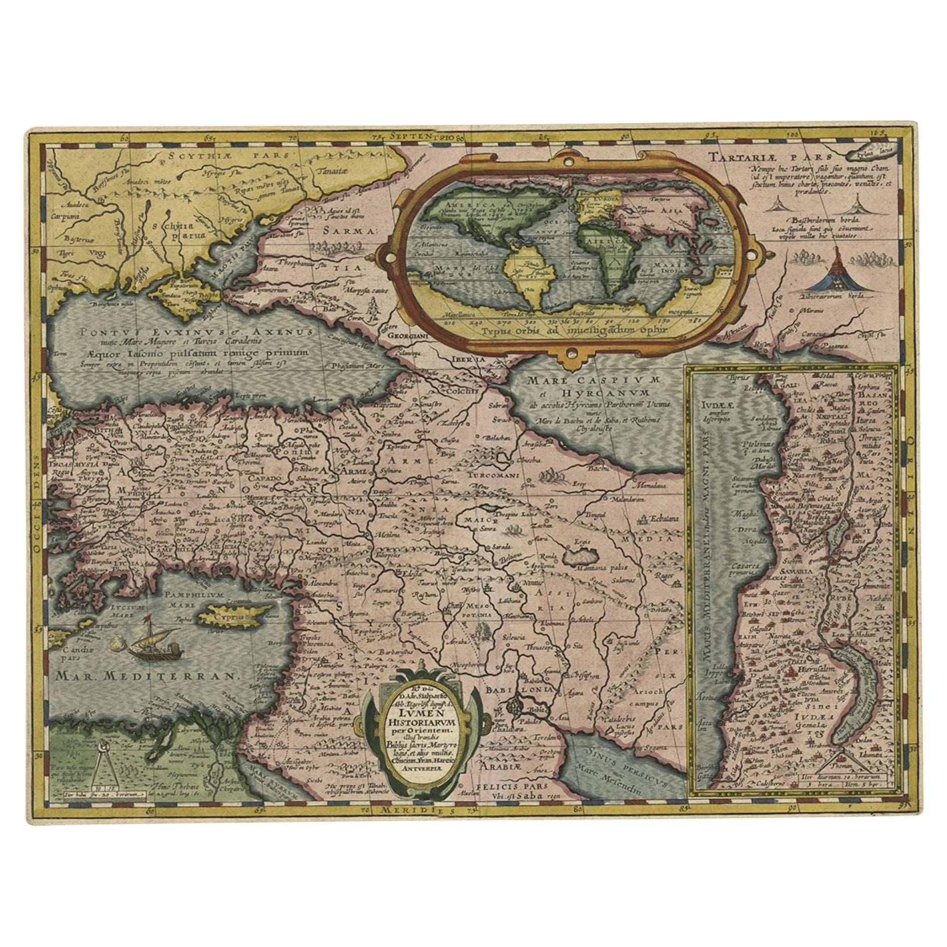
Scarce Antique Map of the Middle East, Surrounded by Latin Text, 1624
Located in Langweer, NL
Antique map titled 'Lumen Historium per Orientem (..).'
Scarce map of the Middle East, surrounded by Latin text. The two insets show Israel and an oval world map. This map (from the last edition of Ortelius Theatri Orbis Terrarum Parergon, 1624) was engraved by Franciscus Hareio. Later, this map was copied by Hornius for his World Atlas (1653).
Artists and Engravers: Franciscus Haraeus (Latinised form of Franciscus Verhaer; also known as Frans Verhaer), (Utrecht 1555? - Leuven, 11 January 1631), was a Dutch theologian, historian, and cartographer. He is best known for his history (from a Catholic point of view) of the Dutch Revolt...
Category
Antique 1620s Maps
Materials
Paper

$905 Sale Price
20% Off
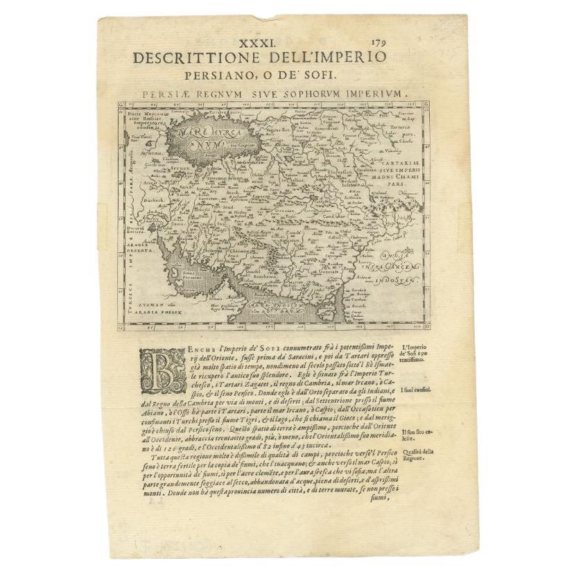
Very Old Antique Map of the Persian Empire by Magini, c.1597
Located in Langweer, NL
Antique map titled 'Persiae Regnum sive Sophorum Imperium'. Old map of the Persian Empire. This map originates from 'Geografia cioe Descrittione Universale della Terra' by G.A. Magin...
Category
Antique 16th Century Maps
Materials
Paper
You May Also Like
Engraving Depicting 16th Century Map of Terra Sancta
Located in Buchanan, MI
Abraham Ortelius (Flemish, 1527-1598) Terra Sancta.
Engraving depicting 16th century map of Terra Sancta. Site 15" x 19.5.
Category
Antique 18th Century and Earlier Maps
Materials
Paper

1592 Abraham Ortelius Map "Lorraine: Lotharingiae Nova Descripti, Ric.A005
Located in Norton, MA
1592 Abraham Ortelius map entitled
"Lorraine: Lotharingiae Nova Descripti
Ric.a005
Description: Ortelius is best known for producing the atlas from which this map comes from, "...
Category
Antique 16th Century Dutch Maps
Materials
Paper

16th c. woodcut map - Tabula Asiae Vlll
By Sebastian Münster
Located in Santa Monica, CA
SEBASTIAN MUNSTER (1488-1652)
ASIAE TABVLA Vlll 1540 (45)
Woodcut from Munster's edition of Geographia Universalis, Basel, Henri Petri. 1545 edit...
Category
16th Century Old Masters Landscape Prints
Materials
Woodcut

$950 Sale Price
29% Off
Ancient Map - Macedonia - Etching by Johannes Janssonius - 1650s
By Johannes Janssonius
Located in Roma, IT
Macedonia is an ancient map realized in 1650 by Johannes Janssonius (1588-1664).
The Map is Hand-colored etching, with coeval watercoloring.
Good condit...
Category
1650s Modern Figurative Prints
Materials
Etching

1627 Hendrik Hondius Map Entitled "Vltoniae Orientalis Pars, " Ric.a009
Located in Norton, MA
1627 Hendrik Hondius map entitled
"Vltoniae orientalis pars,"
Ric.a009
Title:
Vltoniae orientalis : pars
Title (alt.) :
Ultoniae orientalis pars
Creator:
Mercator, Gerh...
Category
Antique 17th Century Dutch Maps
Materials
Paper

1714 Henri Chatelain "Nouvelle Carte Des Etatas Du Grand.Duc De Mos Moscovie Eur
Located in Norton, MA
A 1714 Henri Chatelain map, entitled
"Nouvelle Carte Des Etatas Du Grand Duc De Moscovie En Europe,"
Ricb001
Henri Abraham Chatelain (1684-1743) was a Huguenot pastor of Parisi...
Category
Antique Early 18th Century Dutch Maps
Materials
Paper

More Ways To Browse
Mediterranean Antique
Antique English Bible
Rare Antique Bibles
Rare And Antique Bibles
English Bible
Apostle Paul
Bible 16th Century
King James Bible
Playful Chair
Giacometti Chairs
Antique Rug Wool Navy Blue Red
Bauhaus Flower Stand
French Table With Drawers
North Carolina Furniture
Antique Silver Platter
Boat Blueprint
Cream Plates
Vintage Art Deco Rugs