Items Similar to Roman Gaul & Northern Italy – Antique Map of La Gaule by Andriveau-Goujon, 1861


Want more images or videos?
Request additional images or videos from the seller
1 of 10
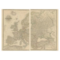
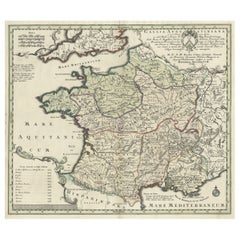
Roman Gaul & Northern Italy – Antique Map of La Gaule by Andriveau-Goujon, 1861
$463.31
£344.42
€390
CA$637.31
A$709.95
CHF 374.49
MX$8,608.34
NOK 4,764.01
SEK 4,437.98
DKK 2,970.53
About the Item
Roman Gaul & Northern Italy – Antique Map of La Gaule by Andriveau-Goujon, 1861
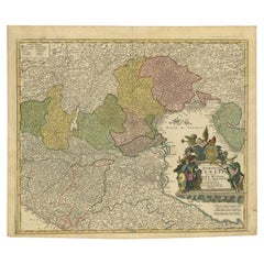
This antique map titled "Carte Comparée de La Gaule" was published in Paris in 1861 by J. Andriveau-Goujon and offers a richly detailed historical representation of ancient Gaul, the Roman provinces of Northern Italy, and part of Germania. Issued as plate 10 in the Atlas Universel, the map provides a comparative cartographic view of Roman territorial divisions overlaid on modern geography, ideal for historians, collectors, and classical scholars.
The map spans a wide swathe of Western Europe, centering on modern-day France but extending into Belgium, Switzerland, Germany, and Northern Italy. Using distinct pastel colors, the map delineates Roman provinces such as Aquitania, Gallia Lugdunensis, Gallia Narbonensis, Belgica, and parts of Germania Superior and Raetia. Many Roman cities are identified with their Latin names — including Lutetia (Paris), Lugdunum (Lyon), Arelate (Arles), Burdigala (Bordeaux), Massilia (Marseille), and Augusta Treverorum (Trier).
The cartouche in the upper right reads:
"Carte Comparée de La Gaule divisée en 17 provinces Romaines, de l’Italie Septentrionale, et d’une partie de la Grande Germanie, publiée par J. Andriveau-Goujon, Rue du Bac No. 4, Paris, 1849", with the date 1861 below, indicating a reissue or updated edition.
The map is surrounded by a bold decorative border and includes longitudinal measurements referenced to Paris. Fine engraving and color printing techniques were used to achieve clear geographic readability, combined with subtle aesthetic appeal.
This map is an exceptional resource for visualizing the Roman Empire’s provincial structure superimposed on the modern layout of Europe. It would be an excellent addition to any collection focused on classical antiquity, Roman cartography, or French historical geography.
Condition: Very good condition. Clean sheet with original hand coloring. Slight toning to edges and minor foxing in blank margins. Centerfold as issued; no tears or repairs. Plate mark visible.
Framing tips: Frame in a dark walnut or black frame with a light cream or off-white mat to enhance the classical appearance. A gold-trimmed inner mat can add a refined historical feel suitable for libraries or academic settings.
Technique: Engraving with original hand coloring
Maker: J. Andriveau-Goujon, Paris, 1861
- Dimensions:Height: 20.91 in (53.1 cm)Width: 27.64 in (70.2 cm)Depth: 0.01 in (0.2 mm)
- Materials and Techniques:Paper,Engraved
- Place of Origin:
- Period:
- Date of Manufacture:1860
- Condition:Condition: Very good condition. Clean sheet with original hand coloring. Slight toning to edges and minor foxing in blank margins. Centerfold as issued; no tears or repairs. Plate mark visible.
- Seller Location:Langweer, NL
- Reference Number:Seller: BG-14099-21stDibs: LU3054346184972
About the Seller
5.0
Recognized Seller
These prestigious sellers are industry leaders and represent the highest echelon for item quality and design.
Platinum Seller
Premium sellers with a 4.7+ rating and 24-hour response times
Established in 2009
1stDibs seller since 2017
2,567 sales on 1stDibs
Typical response time: <1 hour
- ShippingRetrieving quote...Shipping from: Langweer, Netherlands
- Return Policy
Authenticity Guarantee
In the unlikely event there’s an issue with an item’s authenticity, contact us within 1 year for a full refund. DetailsMoney-Back Guarantee
If your item is not as described, is damaged in transit, or does not arrive, contact us within 7 days for a full refund. Details24-Hour Cancellation
You have a 24-hour grace period in which to reconsider your purchase, with no questions asked.Vetted Professional Sellers
Our world-class sellers must adhere to strict standards for service and quality, maintaining the integrity of our listings.Price-Match Guarantee
If you find that a seller listed the same item for a lower price elsewhere, we’ll match it.Trusted Global Delivery
Our best-in-class carrier network provides specialized shipping options worldwide, including custom delivery.More From This Seller
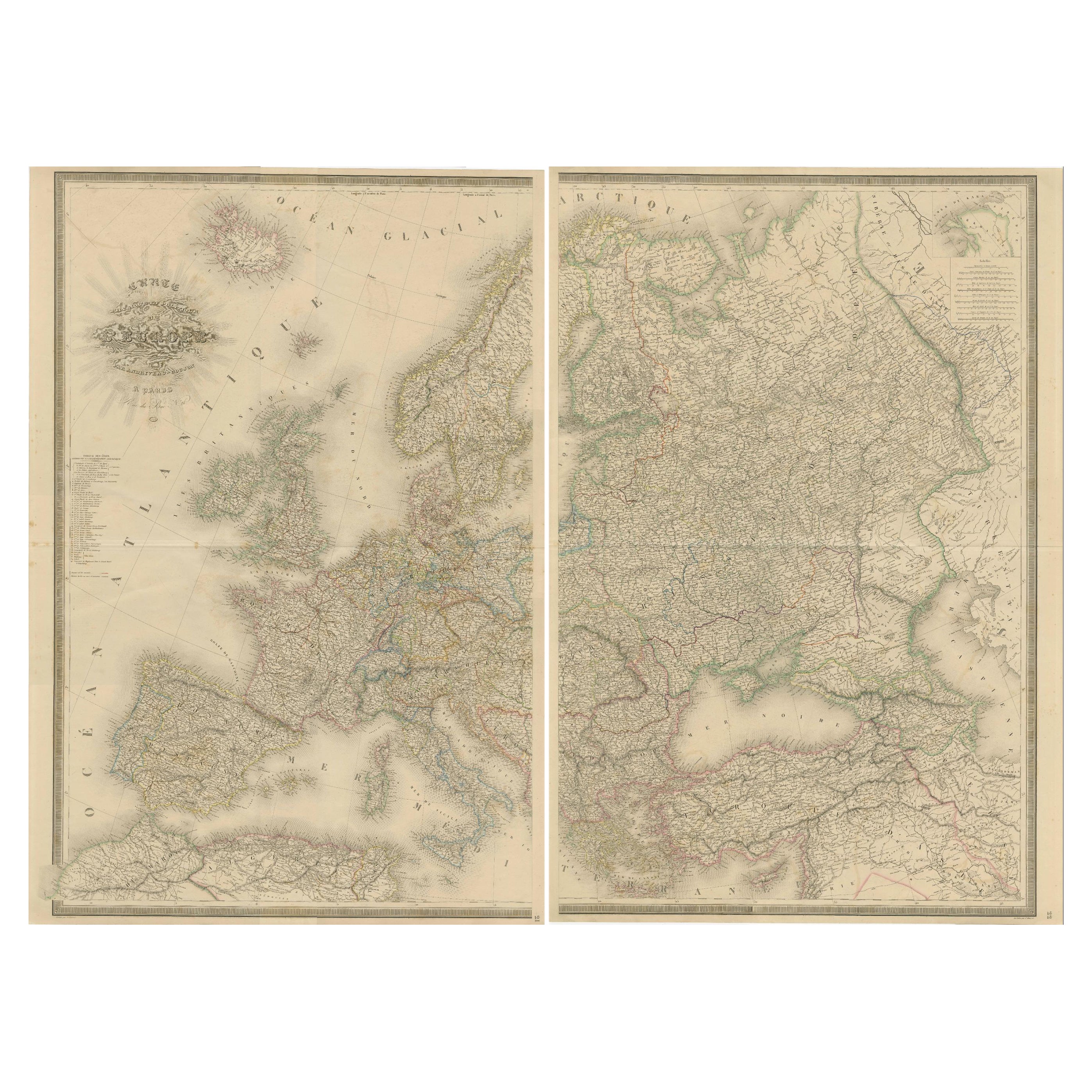
View AllMajestic Map of Europe by Andriveau-Goujon - Complete Continental View - ca.1849
Located in Langweer, NL
Majestic 19th Century Map of Europe by Andriveau-Goujon - Complete Continental View - Circa 1849
This magnificent and intricately detailed map of Europe, titled "Carte Physique et...
Category
Antique 1840s Maps
Materials
Paper
$732 Sale Price / set
20% Off
Large Antique Map of Gaul under Roman Rule, ca.1760
Located in Langweer, NL
Antique map titled 'Gallia Augustiniana in suas provincias divisa (..)'. Large antique map of Roman Gaul, it refers to Gaul under provincial rule in ...
Category
Antique 1760s Maps
Materials
Paper
$399 Sale Price
20% Off
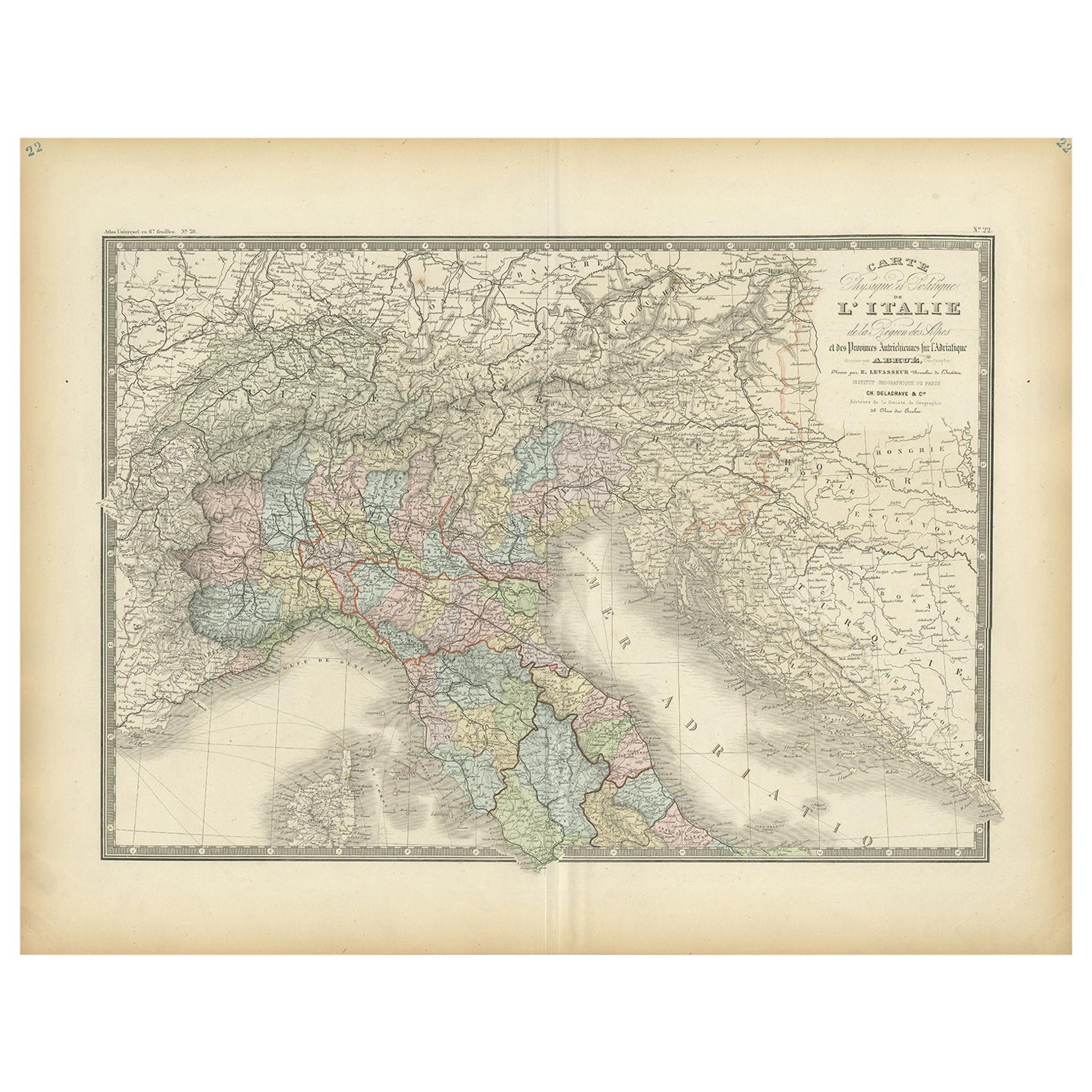
Antique Map of Northern Italy by Levasseur, 1875
Located in Langweer, NL
Antique map titled 'Carte l'Italie (..)'. Large map of Northern Italy. This map originates from 'Atlas de Géographie Moderne Physique et Politique' by A. Levasseur. Published 1875.
Category
Antique Late 19th Century Maps
Materials
Paper
$380 Sale Price
20% Off
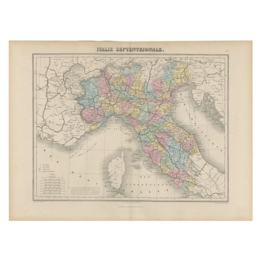
Antique Map of Northern Italy by Migeon, 1880
Located in Langweer, NL
Antique map titled 'Italie Septentrionale'. Old map of the northern part of Italy. This map originates from 'Géographie Universelle Atlas-Migeon' by J. Migeon. Artists and Engravers:...
Category
Antique 19th Century Maps
Materials
Paper
$99 Sale Price
20% Off
Antique Map of Northern Italy by Cluver, 1685
Located in Langweer, NL
Antique map titled 'Histri, Carni, Veneti item Rhaetiae Pars.' Charming miniature map of northern Italy with the Adriatic or upper sea, now called the Gulf of Venice, from the pocket...
Category
Antique 17th Century Maps
Materials
Paper
$190 Sale Price
20% Off
Antique Map of Northern Italy by Homann Heirs, c.1730
Located in Langweer, NL
Antique map titled 'Domini Veneti cum vicinis Parmae Mutinae, Matuae et Mirandol (..).' Detailed map of northern Italy by J. B. Homann. This map shows Venice and its adjacent states ...
Category
Antique 18th Century Maps
Materials
Paper
$494 Sale Price
20% Off
You May Also Like
Antique Map of Italy by Andriveau-Goujon, 1843
By Andriveau-Goujon
Located in New York, NY
Antique Map of Italy by Andriveau-Goujon, 1843. Map of Italy in two parts by Andriveau-Goujon for the Library of Prince Carini at Palazzo Carini i...
Category
Antique 1840s French Maps
Materials
Linen, Paper

$3,350 / set
Large Original Antique Map of Italy. John Dower, 1861
Located in St Annes, Lancashire
Great map of Italy
Lithograph engraving by John Dower
Original colour
Published, 1861
Unframed
Good condition / repair to top right corner seen in last image
Category
Antique 1860s English Victorian Maps
Materials
Paper

Large Original Antique Map of The South of Italy. John Dower, 1861
Located in St Annes, Lancashire
Great map of the South of Italy
Lithograph engraving by John Dower
Original colour
Published, 1861
Unframed
Good condition
Free shipping
Category
Antique 1860s English Victorian Maps
Materials
Paper

Large Original Antique Map of Lombardy and Venice, Italy. John Dower, 1861
Located in St Annes, Lancashire
Great map of Lombardy and Venice
Lithograph engraving by John Dower
Original colour
Published, 1861
Unframed
Good condition / crease to bottom left corner
Free shipping
Category
Antique 1860s English Victorian Maps
Materials
Paper

Original Large Antique Map of Paris, France by John Dower, 1861
Located in St Annes, Lancashire
Fabulous monochrome map of Paris.
Vignettes of St Germain En Laye, Saint Cloud, Versailles and Fontainbleau.
Unframed.
Drawn by J.Dower.
Lithography by Weller. 4 sheets joined to...
Category
Antique 1860s English Victorian Maps
Materials
Paper

Large Original Antique Map of Afghanistan. Edward Weller, 1861
Located in St Annes, Lancashire
Great map of Afghanistan
Lithograph engraving by Edward Weller
Original colour
Published, 1861
Unframed
Good condition
Category
Antique 1860s English Victorian Maps
Materials
Paper
