Items Similar to Turkey in Asia – Antique Ottoman Empire Map by John Tallis, ca. 1851


Want more images or videos?
Request additional images or videos from the seller
1 of 10
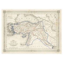
Turkey in Asia – Antique Ottoman Empire Map by John Tallis, ca. 1851
$324.82
£244.06
€275
CA$447.28
A$500.59
CHF 262.04
MX$6,081.31
NOK 3,327.28
SEK 3,139.86
DKK 2,093.02
About the Item
Turkey in Asia – Antique Ottoman Empire Map by John Tallis, ca. 1851
This decorative 19th-century map titled "Turkey in Asia" was published by John Tallis & Company around 1851. Engraved by the renowned cartographer J. Rapkin, with vignettes by H. Warren and J. Rogers, this map is one of the most visually striking representations of the Ottoman Empire’s Asian provinces produced during the Victorian era.
The map depicts an extensive region of the Middle East under Ottoman rule, including modern-day Turkey, Syria, Iraq, Lebanon, Jordan, Israel, and parts of Saudi Arabia and Iran. Cities, mountain ranges, rivers, and political boundaries are precisely rendered and enhanced with fine hand coloring. Place names such as Baghdad, Damascus, Mecca, and Jerusalem are clearly marked, providing a fascinating snapshot of the 19th-century geopolitical landscape.
Surrounding the map is Tallis’s iconic ornamental border, and the plate is further enriched by finely engraved vignette illustrations. These include a view of Jerusalem, a camel in the Arabian desert, figures in traditional Bedouin and Middle Eastern dress, and a landscape of Mount Lebanon. These romanticized views were intended to appeal to European audiences fascinated by the exoticism of the Orient.
John Tallis’s maps are widely admired for their balance of cartographic detail and artistic embellishment. They were originally issued in Tallis’s “Illustrated Atlas,” which aimed to present up-to-date geographic knowledge alongside cultural and ethnographic illustrations. Maps from this series remain highly collectable today due to their aesthetic appeal and historical significance.
This map is a fine example for collectors of Ottoman history, antique cartography, or decorative 19th-century engravings. It is especially attractive for framing due to its vivid border, hand coloring, and rich engravings.
Condition: Good impression with original outline hand coloring. Minor age toning, old folds as issued, and slight edge wear. No tears or significant staining.
Framing tips: A warm, classic wood frame with a cream or antique white mat will highlight the decorative border. Consider museum glass for protection and clarity.
Technique: Steel engraving with hand coloring
Maker: John Tallis & Co., London & New York, circa 1851
- Dimensions:Height: 10.44 in (26.5 cm)Width: 14.65 in (37.2 cm)Depth: 0.02 in (0.5 mm)
- Materials and Techniques:Paper,Engraved
- Place of Origin:
- Period:
- Date of Manufacture:circa 1851
- Condition:Condition: Good impression with original outline hand coloring. Minor age toning, old folds as issued, and slight edge wear. No tears or significant staining.
- Seller Location:Langweer, NL
- Reference Number:Seller: BG-035351stDibs: LU305439442483
About the Seller
5.0
Recognized Seller
These prestigious sellers are industry leaders and represent the highest echelon for item quality and design.
Platinum Seller
Premium sellers with a 4.7+ rating and 24-hour response times
Established in 2009
1stDibs seller since 2017
2,535 sales on 1stDibs
Typical response time: <1 hour
- ShippingRetrieving quote...Shipping from: Langweer, Netherlands
- Return Policy
Authenticity Guarantee
In the unlikely event there’s an issue with an item’s authenticity, contact us within 1 year for a full refund. DetailsMoney-Back Guarantee
If your item is not as described, is damaged in transit, or does not arrive, contact us within 7 days for a full refund. Details24-Hour Cancellation
You have a 24-hour grace period in which to reconsider your purchase, with no questions asked.Vetted Professional Sellers
Our world-class sellers must adhere to strict standards for service and quality, maintaining the integrity of our listings.Price-Match Guarantee
If you find that a seller listed the same item for a lower price elsewhere, we’ll match it.Trusted Global Delivery
Our best-in-class carrier network provides specialized shipping options worldwide, including custom delivery.More From This Seller
View AllAntique Map of Turkey in Asia by Wyld '1845'
Located in Langweer, NL
Antique map titled 'Map of Turkey in Asia'. Original antique map of Turkey in Asia. This map originates from 'An Atlas of the World, Comprehendin...
Category
Antique Mid-19th Century Maps
Materials
Paper

$188 Sale Price
20% Off
Antique Map of Turkey in Asia by A & C. Black, 1870
Located in Langweer, NL
Antique map titled 'Turkey in Asia'. Original antique map of Turkey in Asia with inset Ruins of Babylon. This map originates from ‘Black's General Atlas of The World’. Published by A...
Category
Antique Late 19th Century Maps
Materials
Paper

$165 Sale Price
20% Off
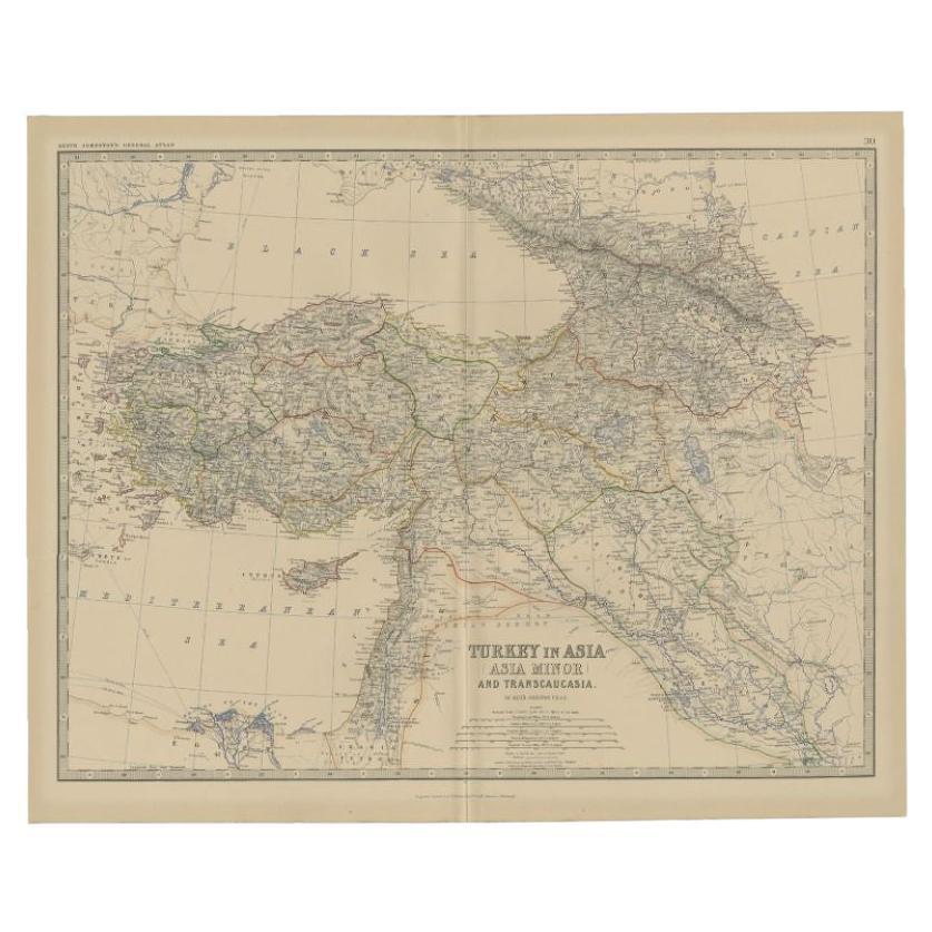
Antique Map of Turkey in Asia by A.K. Johnston, 1865
Located in Langweer, NL
Antique map titled 'Turkey in Asia (Asia Minor) and Transcaucasia'. This map originates from the ‘Royal Atlas of Modern Geography’ by Alexander Keith Johnston. Published by William B...
Category
Antique Mid-19th Century Maps
Materials
Paper
$259 Sale Price
20% Off
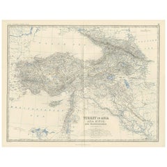
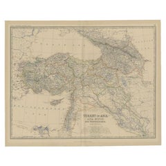
Antique Map of Turkey in Asia by Johnston, 1882
Located in Langweer, NL
Antique map titled 'Turkey in Asia (Asia Minor) and Transcaucasia'. Old map of Turkey in Asia (Asia Minor). This map originates from 'The Royal Atlas of Modern Geography, Exhibiting,...
Category
Antique 19th Century Maps
Materials
Paper
$368 Sale Price
20% Off
Antique Map of Asia Minor by J. Tallis, circa 1851
Located in Langweer, NL
A highly decorative mid-19th century map of 'Asia Minor' (modern day Turkey) which was drawn and engraved by J. Rapkin and published in John Tallis's Illust...
Category
Antique Mid-19th Century Maps
Materials
Paper

$259 Sale Price
20% Off
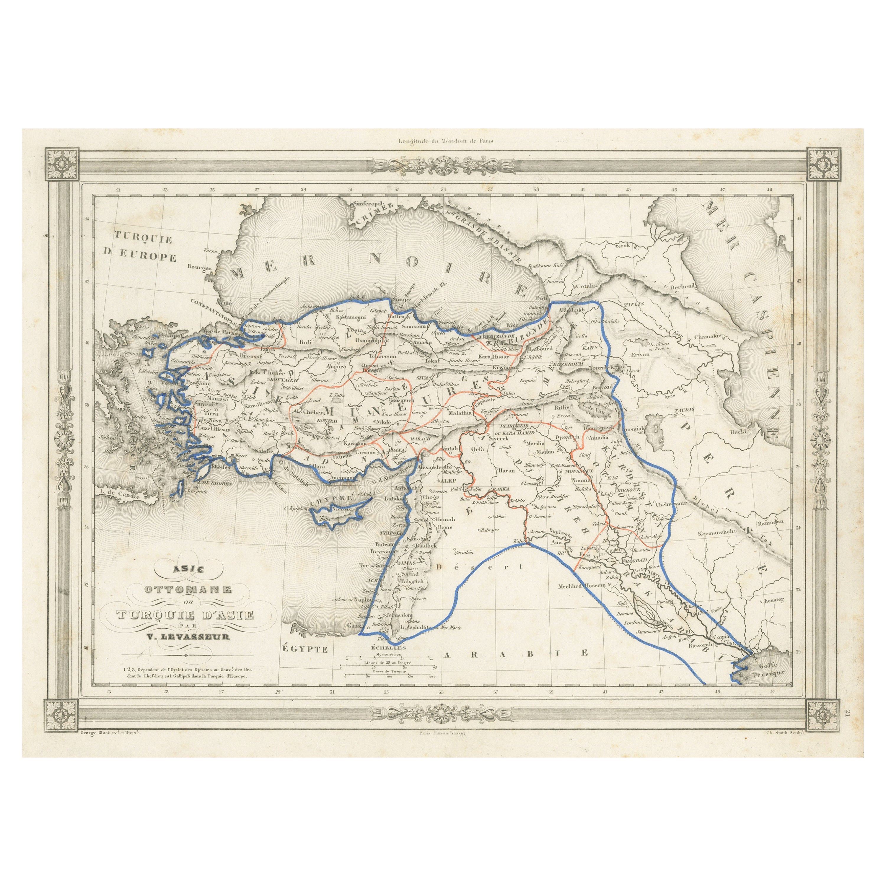
Antique Map of Turkey in Asia, with Frame Style Border
Located in Langweer, NL
Antique map titled 'Asie Ottomane ou Turquie d'Asie'. Attractive map of Turkey in Asia. The map covers the Asian territories claimed by the Turkish Ottoman Empire c.1850 from the Bla...
Category
Antique Mid-19th Century Maps
Materials
Paper
$157 Sale Price
30% Off
You May Also Like
Circa 1825 original engraving of the map of Syria by Giraldon Bovinet
Located in PARIS, FR
The circa 1825 original engraving of "Syrie" by Giraldon Bovinet, based on the work of L. Vivien, is a historically significant map that reflects early 19th-century cartographic tech...
Category
1820s Prints and Multiples
Materials
Engraving, Paper

Antique 1803 Italian Map of Asia Including China Indoneseia India
Located in Amsterdam, Noord Holland
Antique 1803 Italian Map of Asia Including China Indoneseia India
Very nice map of Asia. 1803.
Additional information:
Type: Map
Country of Manufacturing: Europe
Period: 19th centu...
Category
Antique 19th Century European Maps
Materials
Paper

$584 Sale Price
20% Off
Large Original Antique Map of Cyprus. 1894
Located in St Annes, Lancashire
Superb Antique map of Cyprus
Published Edward Stanford, Charing Cross, London 1894
Original colour
Good condition
Unframed.
Free shipping
Category
Antique 1890s English Maps
Materials
Paper

Original Antique Map of Ancient Greece, Achaia, Corinth, 1786
Located in St Annes, Lancashire
Great map of Ancient Greece. Showing the region of Thessaly, including Mount Olympus
Drawn by J.D. Barbie Du Bocage
Copper plate engraving by P.F Tardieu
Original hand color...
Category
Antique 1780s French Other Maps
Materials
Paper

Large Original Antique Map of Asia by Sidney Hall, 1847
Located in St Annes, Lancashire
Great map of Asia
Drawn and engraved by Sidney Hall
Steel engraving
Original colour outline
Published by A & C Black. 1847
Unframed
Free shipping
Category
Antique 1840s Scottish Maps
Materials
Paper

1851 Map of "Independent Tartary", Ric. R018
Located in Norton, MA
1851 Map of
Independent Tartary
"Russia"
Ric.r018
A highly decorative 1851 map of Independent Tartary by John Tallis and John Rapkin. Covers the regions between the Caspian Sea and Lake Bakquash and between Russia and Afghanistan. These include the ancient Silk Route kingdoms of Khiva, Tartaria, Kokand, and Bokhara. Today this region roughly includes Kazakhstan, Uzbekistan, Turkmenistan, Kyrgyzstan, and Tajikistan. This wonderful map offers a wealth of detail for anyone with an interest in the Central Asian portion of the ancient Silk Road. Identifies various caravan routes, deserts, wells, and stopping points, including the cities of Bokhara and Samarkand. Three vignettes by W. Bragg decorate the map, these including an image of Tartars on a Journey, a horseback Bride Chase, and a tartar camp site. Surrounded by a vine motif border. Engraved by J. Rapkin for John Tallis's 1851 Illustrated Atlas .
Tartary Antique Map...
Category
Antique 19th Century Unknown Maps
Materials
Paper

More Ways To Browse
Antique Ostrich
Ostrich Ottoman
Japanese Silver Ceramics
One Of A Kind Chair
Used Oak Dining Room Chairs
Childrens Vintage Poster
Vintage Travel Poster Mid Century
Desk Key
Carved Cabriole Table
Dark Antique Table
White Wooden Table
Antique Wall Table
1960 Chair Wood Danish
Unusual Dining Table
Antique Dutch Plates
Mdf Table
Showcase Coffee Table
Space Age Orange