Items Similar to Victorian Visions of the New World: A Detailed Tallis Map of North America, 1851


Want more images or videos?
Request additional images or videos from the seller
1 of 10
Victorian Visions of the New World: A Detailed Tallis Map of North America, 1851
$345.07
$431.3320% Off
£256.88
£321.1020% Off
€288
€36020% Off
CA$472.65
CA$590.8220% Off
A$525.69
A$657.1220% Off
CHF 274.50
CHF 343.1320% Off
MX$6,397.13
MX$7,996.4220% Off
NOK 3,505.79
NOK 4,382.2420% Off
SEK 3,287.82
SEK 4,109.7720% Off
DKK 2,192.44
DKK 2,740.5520% Off
Shipping
Retrieving quote...The 1stDibs Promise:
Authenticity Guarantee,
Money-Back Guarantee,
24-Hour Cancellation
About the Item
The map presented here is an intricate example from the series of maps produced by John Tallis & Company. Tallis maps are known for their detailed and elaborate style, often including ornate borders and vignettes that add a narrative element to the geographical representation. They are a blend of cartography and Victorian artistic sensibilities.
The mapmaker, John Tallis, is recognized for his mid-19th-century maps that were not only tools for navigation but also for education and display, reflecting the era's fascination with geography and empire. The collaboration with John Rapkin, the cartographer, ensured that the maps were both accurate for their time and aesthetically appealing.
This particular map illustrates North America, detailing the political boundaries, cities, and topography with hand-colored regions. The vignettes surrounding the map are of particular interest:
- Top Left: Depicts what seems to be indigenous people of the Arctic region, interacting with European explorers or traders. This scene might represent the meeting of cultures in the northern parts of North America.
- Top Right: Illustrates polar scenes, with a focus on polar bears, which captures the imagination and represents the unknown territories.
- Bottom Left: Shows a group of North American Indigenous peoples in traditional attire, providing a romanticized glimpse into the lives of the original inhabitants of the continent.
- Bottom Right: Depicts a group of figures in colonial attire, perhaps traders or explorers, with a ship in the background, representing exploration and trade.
- Bottom Center: Features an ancient monument in Mexico, showcasing the historical and archaeological interest of the Victorian era in the pre-Columbian civilizations of North America.
Like the other maps in the Tallis series, this one is rich in cultural and historical context, and it's indicative of the British imperialistic view during that time. It was designed to illustrate the world under British influence and to appeal to the British public's sense of curiosity and ownership over diverse territories.
The series including maps of various parts of the British Empire and beyond was not only a display of cartographic achievement but also a showcase of the reach and diversity of the British Empire, with an underlying intention of impressing and educating the map’s viewers.
- Dimensions:Height: 14.26 in (36.2 cm)Width: 10.71 in (27.2 cm)Depth: 0 in (0.02 mm)
- Materials and Techniques:
- Period:
- Date of Manufacture:1851
- Condition:Good given age. Original fold in middle as published. General age-related toning, please study scan carefully.
- Seller Location:Langweer, NL
- Reference Number:Seller: BG-13736-171stDibs: LU3054339298802
About the Seller
5.0
Recognized Seller
These prestigious sellers are industry leaders and represent the highest echelon for item quality and design.
Platinum Seller
Premium sellers with a 4.7+ rating and 24-hour response times
Established in 2009
1stDibs seller since 2017
2,510 sales on 1stDibs
Typical response time: <1 hour
- ShippingRetrieving quote...Shipping from: Langweer, Netherlands
- Return Policy
Authenticity Guarantee
In the unlikely event there’s an issue with an item’s authenticity, contact us within 1 year for a full refund. DetailsMoney-Back Guarantee
If your item is not as described, is damaged in transit, or does not arrive, contact us within 7 days for a full refund. Details24-Hour Cancellation
You have a 24-hour grace period in which to reconsider your purchase, with no questions asked.Vetted Professional Sellers
Our world-class sellers must adhere to strict standards for service and quality, maintaining the integrity of our listings.Price-Match Guarantee
If you find that a seller listed the same item for a lower price elsewhere, we’ll match it.Trusted Global Delivery
Our best-in-class carrier network provides specialized shipping options worldwide, including custom delivery.More From This Seller
View AllAntique Map of North America by A & C. Black, 1870
Located in Langweer, NL
Antique map titled 'North America'. Original antique map of North America. This map originates from ‘Black's General Atlas of The World’. Published by A & C. Black, 1870.
Category
Antique Late 19th Century Maps
Materials
Paper

$263 Sale Price
20% Off
Antique Map of North America, 1821
Located in Langweer, NL
Antique map of America titled 'Carte de l'Amerique septentrionale'. Scarce map of North America, shortly after the Louisiana Purchase and the first ...
Category
Antique 19th Century Maps
Materials
Paper

$623 Sale Price
20% Off
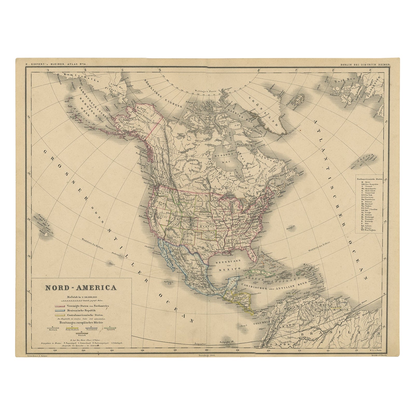
Old Original Antique German Map of North America, ca.1870
Located in Langweer, NL
Antique map titled 'Nord-America'.
Old map of North America. This map originates from 'H. Kiepert's Kleiner Atlas der Neueren Geographie für Schule und Haus'.
Artists and Engrave...
Category
Antique 1870s Maps
Materials
Paper

$469 Sale Price
20% Off
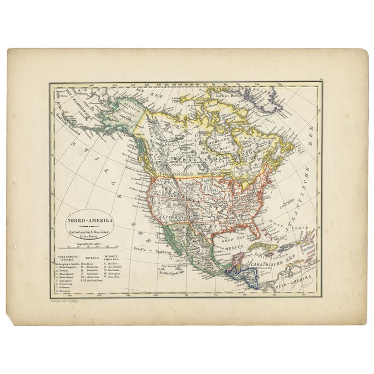
Antique Map of North America from an Old Dutch School Atlas, 1852
Located in Langweer, NL
Antique map titled 'Noord-Amerika'. Map of North America. This map originates from 'School-Atlas van alle deelen der Aarde' by Otto Petri. Artists and Engra...
Category
Antique 19th Century Maps
Materials
Paper

$210 Sale Price
20% Off
Antique Map of North America by Lowry '1852'
Located in Langweer, NL
Antique map titled 'North America'. Original map of North America. This map originates from 'Lowry's Table Atlas constructed and engraved from the...
Category
Antique Mid-19th Century Maps
Materials
Paper

$143 Sale Price
20% Off
Antique Map of North America by Johnston, 1882
By Alexander Keith Johnston
Located in Langweer, NL
Antique map titled 'North America'.
Old map of North America. This map originates from 'The Royal Atlas of Modern Geography, Exhibiting, in a Series of Entirely Original and Authen...
Category
Antique 19th Century Maps
Materials
Paper

You May Also Like
Original Antique Map of North America by Dower, circa 1835
Located in St Annes, Lancashire
Nice map of North America
Drawn and engraved by J.Dower
Published by Orr & Smith. C.1835
Unframed.
Free shipping
Category
Antique 1830s English Maps
Materials
Paper

1846 "North America" Map, Engraved by I. Dower
Located in Colorado Springs, CO
Presented is an original 1846 map of “North America.” The map was drawn and engraved by I. Dower and published in London by Orr & Company. The map depicts North America, to include G...
Category
Antique 1840s English Victorian Maps
Materials
Paper

1864 Map of North America, Antique Hand-Colored Map, by Adolphe Hippolyte Dufour
Located in Colorado Springs, CO
Offered is a map of North America entitled Amerique du Nord from 1864. This rare, separately published wall map was produced by Adolphe Hippolyte Dufour. This map includes vibrant an...
Category
Antique 1860s French Maps
Materials
Paper

1859 "Map of the United States of America..." by J. H. Colton
By J.H. Colton
Located in Colorado Springs, CO
Presented is an 1859 “Map of the United States of America, the British Provinces, Mexico, the West Indies and Central America with Part of...
Category
Antique 1850s American Maps
Materials
Paper

Large Original Vintage Map of North America, circa 1920
Located in St Annes, Lancashire
Great map of North America
Original color. Good condition
Published by Alexander Gross
Unframed.
Category
Vintage 1920s English Edwardian Maps
Materials
Paper

Original Antique Map of United States, Grattan and Gilbert, 1843
Located in St Annes, Lancashire
Great map of United States
Drawn and engraved by Archer
Published by Grattan and Gilbert. 1843
Original colour
Unframed.
Category
Antique 1840s English Maps
Materials
Paper

More Ways To Browse
British Empire
Antique Oushak Carpets
Blue Coffee Tables
1945 Chair Juhl
Antique Three Leg Table
Folke Arstrom
Silver Over Copper
Vintage Barware Glasses
Antique Etched Glass
Antique French Shell
Coffee Table Black Italian Modern
Christofle America
Iranian Silk Rug Carpet
Poul Moller
Tables With Inlaid Wood
World War Table
Antonio Jacobsen
Ariston Chairs