Items Similar to Views of St. Denis and St. Paul, Île de Bourbon – Antique French Engraving, 1790
Want more images or videos?
Request additional images or videos from the seller
1 of 10
Views of St. Denis and St. Paul, Île de Bourbon – Antique French Engraving, 1790
$402.98
£300.02
€340
CA$555.25
A$618.27
CHF 326.95
MX$7,523.91
NOK 4,121.32
SEK 3,882.89
DKK 2,588.26
About the Item
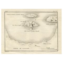
Views of St. Denis and St. Paul, Île de Bourbon – Antique French Engraving by Portier, c.1790
This antique French engraving by Portier, produced around 1790, presents two coastal views of settlements on Île de Bourbon, the 18th-century name for present-day Réunion in the Indian Ocean. The upper panel depicts the “Vue du Bourg de St. Denis,” while the lower shows the “Vue du Bourg de St. Paul,” each captured from an offshore perspective.
In the view of St. Denis, the settlement is nestled along a rugged coastline backed by steep, jagged mountains. A few ships sail offshore, indicating the island’s role as a stopover for maritime trade between Europe, Africa, and Asia. The St. Paul view features a broader sweep of the coastline, with more visible buildings lining the shore and a ship anchored in the calm waters beyond.
Île de Bourbon was a strategic French colony in the 18th century, prized for its sugar and coffee production as well as its position along East Indies trade routes. Portier’s engravings combine artistic charm with topographical accuracy, offering valuable insight into the early colonial landscape of Réunion. The fine hachuring and horizontal line shading effectively convey the island’s dramatic volcanic terrain and the surrounding sea.
Such coastal profile engravings were often included in illustrated travel accounts, missionary reports, and geographical works of the period, serving as visual references for navigators and scholars alike.
Condition report: Very good condition with a strong plate mark and crisp impression. Light toning along the fold and faint marginal foxing. Paper is stable and well-preserved.
Framing tips: This engraving would look striking in a horizontal frame to preserve the original layout, with a cream archival mat to complement the warm paper tone. A dark wood or black frame would enhance the fine linework.
Technique: Engraving
Maker: Portier, France, c.1790
- Dimensions:Height: 5.83 in (14.8 cm)Width: 7.88 in (20 cm)Depth: 0.01 in (0.2 mm)
- Materials and Techniques:Paper,Engraved
- Place of Origin:
- Period:
- Date of Manufacture:circa 1790
- Condition:Condition report: Very good condition with a strong plate mark and crisp impression. Light toning along the fold and faint marginal foxing. Paper is stable and well-preserved.
- Seller Location:Langweer, NL
- Reference Number:Seller: BG-14078-191stDibs: LU3054346211392
About the Seller
5.0
Recognized Seller
These prestigious sellers are industry leaders and represent the highest echelon for item quality and design.
Platinum Seller
Premium sellers with a 4.7+ rating and 24-hour response times
Established in 2009
1stDibs seller since 2017
2,567 sales on 1stDibs
Typical response time: <1 hour
- ShippingRetrieving quote...Shipping from: Langweer, Netherlands
- Return Policy
Authenticity Guarantee
In the unlikely event there’s an issue with an item’s authenticity, contact us within 1 year for a full refund. DetailsMoney-Back Guarantee
If your item is not as described, is damaged in transit, or does not arrive, contact us within 7 days for a full refund. Details24-Hour Cancellation
You have a 24-hour grace period in which to reconsider your purchase, with no questions asked.Vetted Professional Sellers
Our world-class sellers must adhere to strict standards for service and quality, maintaining the integrity of our listings.Price-Match Guarantee
If you find that a seller listed the same item for a lower price elsewhere, we’ll match it.Trusted Global Delivery
Our best-in-class carrier network provides specialized shipping options worldwide, including custom delivery.More From This Seller
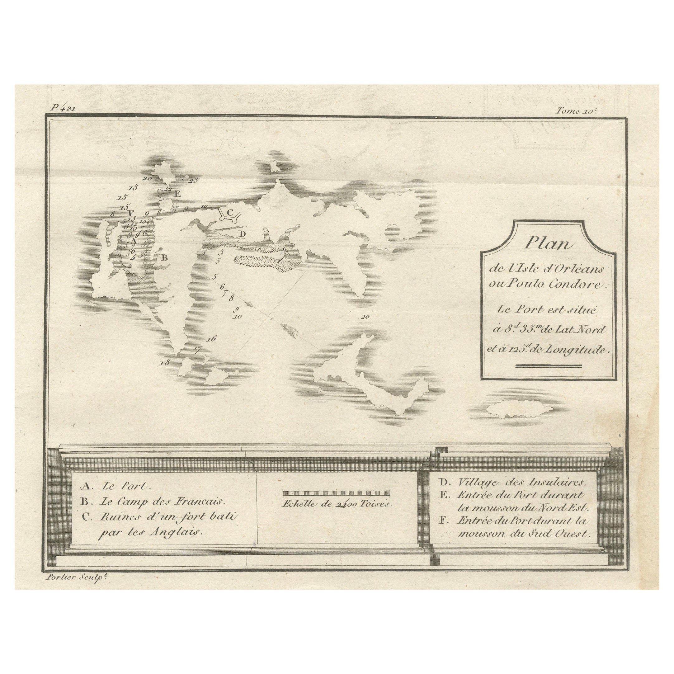
View AllPlan of Poulo Condore (Côn Sơn Island) – Antique French Engraving, ca.1790
Located in Langweer, NL
Plan of Poulo Condore (Côn Sơn Island) – Antique French Engraving by Portier, c.1790
This antique French engraving, created by Portier around 1790, presents a detailed plan of Poulo...
Category
Antique Late 18th Century French Maps
Materials
Paper
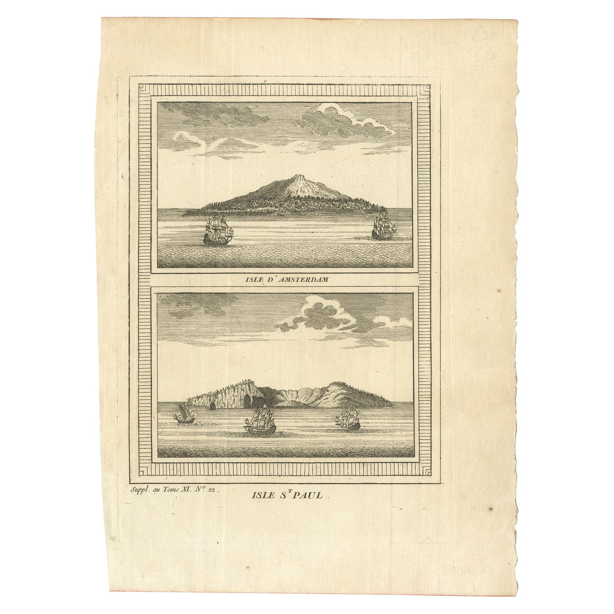
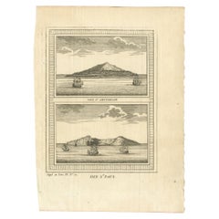
Antique Print of Amsterdam and St. Paul Island by Bellin '1753'
By Jacques-Nicolas Bellin
Located in Langweer, NL
Antique print titled 'Isle d'Amsterdam, Isle St. Paul'. Two images on one sheet depicting Amsterdam and St. Paul island. The Dutch captain Anthonie van Diemen named it island Nieuw Amsterdam...
Category
Antique Mid-18th Century Prints
Materials
Paper
$90 Sale Price
20% Off
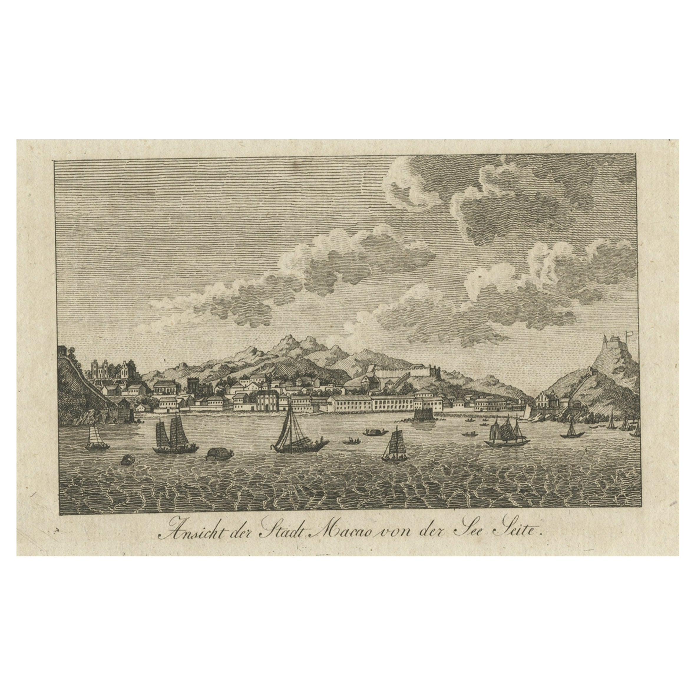
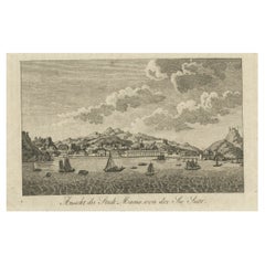
Antique German Print of Macau or Macao in Asia, Published Around 1800
Located in Langweer, NL
Description: Antique print China titled 'Ansicht der Stadt Macao von der See Seite'. Miniature view of the city of Macao/Macau, China. The scene il...
Category
Antique Early 19th Century Maps
Materials
Paper
$151 Sale Price
20% Off
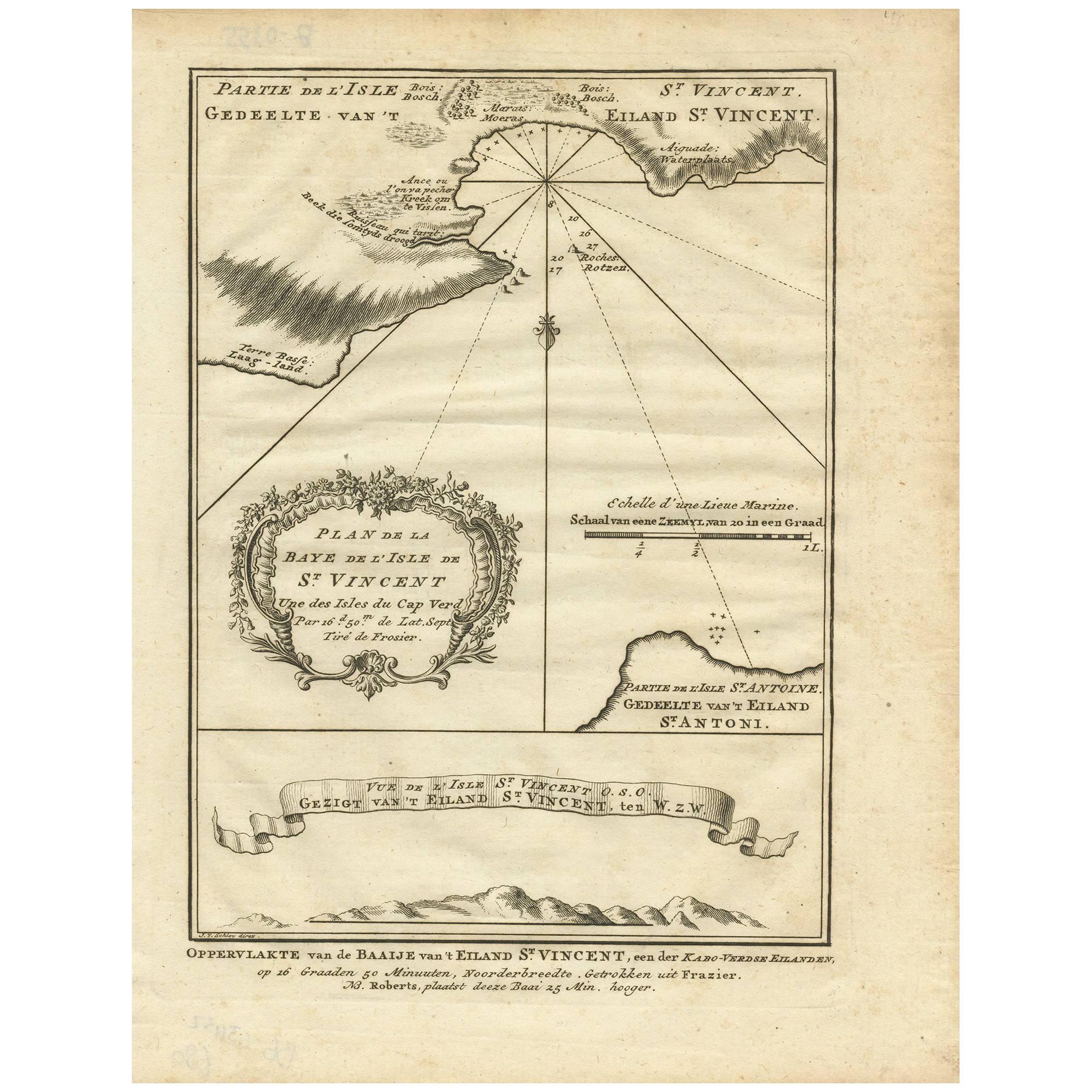
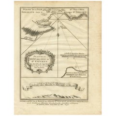
Antique Print of the Bay of the Island of St. Vincent by Van Schley (1747)
Located in Langweer, NL
Antique print titled 'Oppervlakte van de Baaije van 't Eiland St. Vincent (..)'. View of the Bay of the Island of St. Vincent, one of the Capeverdian Islands. Originates from a Dutch...
Category
Antique Mid-18th Century Maps
Materials
Paper
$104 Sale Price
20% Off
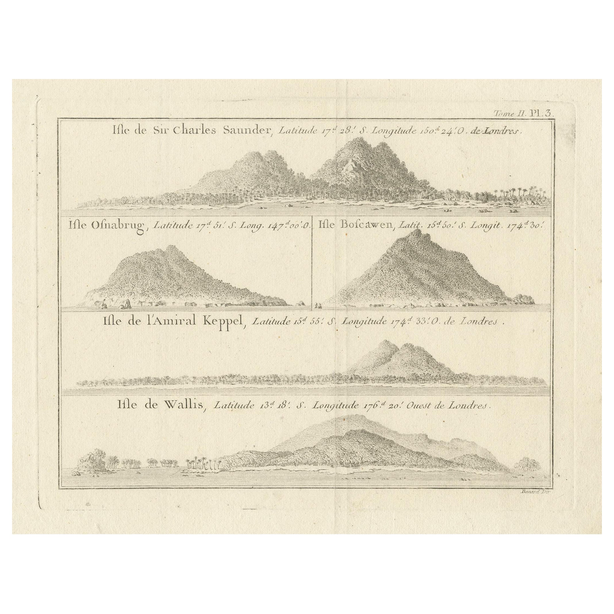
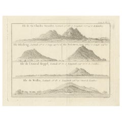
Antique Print with Views of Sir Charles Saunders Island and Other Islands, 1774
Located in Langweer, NL
Explore the captivating world of the 18th century with this exquisite antique print titled 'Isles de Sir Charles Saunder Latitude (...)'. I A journey through time as you delve into t...
Category
Antique Late 18th Century Maps
Materials
Paper
$303 Sale Price
20% Off
Free Shipping
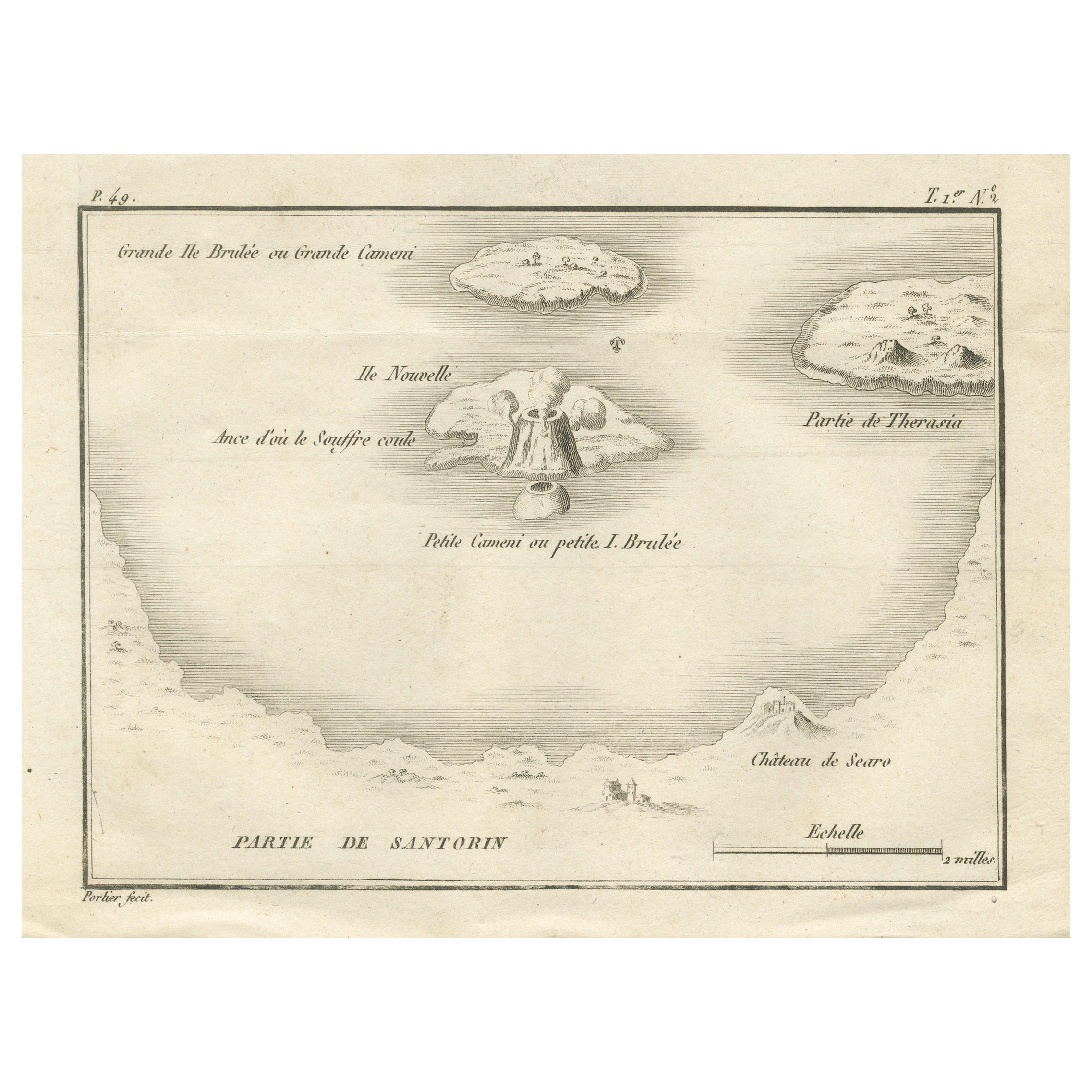
Map of the Volcano Islands of Santorini – Antique Engraving by Portier, ca.1790
Located in Langweer, NL
Map of the Volcano Islands of Santorini – Antique French Engraving by Portier, c.1790
This antique French engraving presents a detailed view of the volcanic islands at the center of...
Category
Antique Late 18th Century French Maps
Materials
Paper
You May Also Like
17th Century Topographical Engraving Nantes & St. Malo, France, by Iohan Peeters
Located in New York, NY
The ancient city of Saint Malo in North Western France has long been associated with adventure on the high seas, piracy and exploration. It was the birthplace of several important in...
Category
Antique 17th Century Dutch Maps
Materials
Paper

View of the City of Paris from the side of the island called... - Etching - 1748
Located in Roma, IT
Etching on paper realized in 1748.
Very good condition except for some minor foxing.
Includes a wooden frame cm. 27.5x41.5
Category
1740s Modern Abstract Prints
Materials
Etching
Vue d'un Village près de la Ville de Berne, Switzerland, engraving, 1780
Located in Melbourne, Victoria
'Vue d'un Village près de la Ville de Berne'
French copper-line engraving by Masquelier after Claude Louis Chatelet (1753-1794).
From 'The Scenery and Science of Switzerland illust...
Category
1780s Naturalistic Landscape Prints
Materials
Engraving

Vue de la Ville et du Lac de Geneve, Switzerland, copper-line engraving, c1780
Located in Melbourne, Victoria
French copper-line engraving depicting the Town and Lake of Geneva, Switzerland.
Claude-Louis Chatelet was a distinguished French painter, draftsman an...
Category
1780s Naturalistic Landscape Prints
Materials
Engraving
Pierre Gabriel Bernhault ca. 1800 Engraving "Vue intérieure de Paris"
By Pierre Gabriel Berthault
Located in Chicago, IL
A ca. 1800 engraving by Pierre Gabriel Berthault, "Vue intérieure de Paris prise du milieu du Pont Royal regardant le Pont Neuf". Artwork size: 16 3/8" x 26". archivally matted to...
Category
Early 1800s French School Landscape Prints
Materials
Engraving, Paper
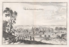
Castle and Town of Tanlay, French architecture, mid 17th century engraving
By Matthaeus Merian
Located in Melbourne, Victoria
'Prosp du Chasteau et Bourg de Tanlay'
Copper-line engraving by Matthaeus Merian.
From 'Topographia Galliae', a fine series of engravings of 17th-century French landscapes, garden...
Category
Mid-18th Century Rococo Landscape Prints
Materials
Engraving