Items Similar to Antique Print with Views of Sir Charles Saunders Island and Other Islands, 1774
Want more images or videos?
Request additional images or videos from the seller
1 of 6
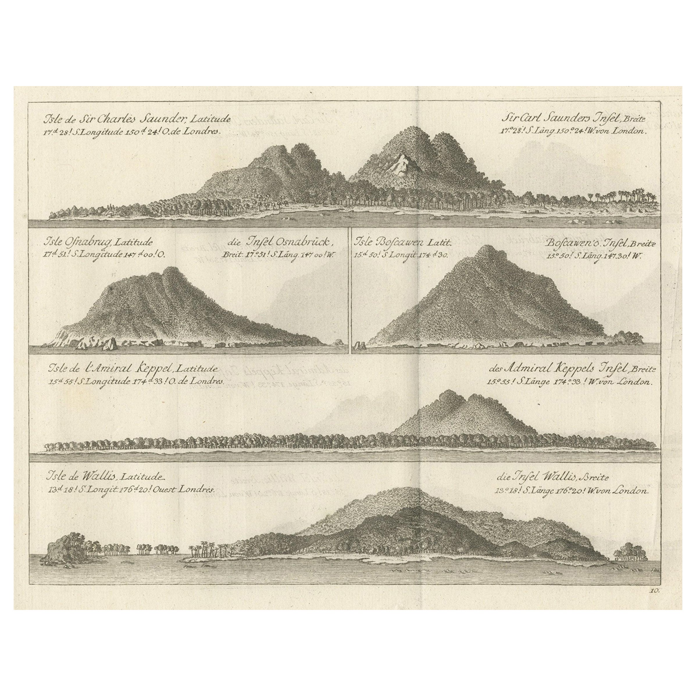
Antique Print with Views of Sir Charles Saunders Island and Other Islands, 1774
About the Item
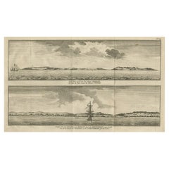
Explore the captivating world of the 18th century with this exquisite antique print titled 'Isles de Sir Charles Saunder Latitude (...)'. I A journey through time as you delve into the coastal views of Sir Charles Saunders Island, Osnaburg Island (now known as Mehetia in French Polynesia), Boscawens Island (modern-day Tafahi in Tonga), Admiral Keppel's Island (Niuatoputapu), and Wallis Island (Uvea).
This remarkable map is a precious relic from the French edition of 'An Account of the Voyages Undertaken by the Order of His Present Majesty for Making Discoveries in the Southern Hemisphere' by John Hawkesworth, dating back to approximately 1774. A window into the age of exploration and discovery, this antique map invites you to relive the adventures of early explorers and marvel at the uncharted territories of the past.
- Dimensions:Height: 10.75 in (27.3 cm)Width: 13.12 in (33.3 cm)Depth: 0.02 in (0.5 mm)
- Materials and Techniques:Paper,Engraved
- Period:
- Date of Manufacture:circa 1774
- Condition:General age-related toning. Minor wear and soiling, blank verso. Please study image carefully.
- Seller Location:Langweer, NL
- Reference Number:
About the Seller
5.0
Platinum Seller
These expertly vetted sellers are 1stDibs' most experienced sellers and are rated highest by our customers.
Established in 2009
1stDibs seller since 2017
1,922 sales on 1stDibs
Typical response time: <1 hour
- ShippingRetrieving quote...Ships From: Langweer, Netherlands
- Return PolicyA return for this item may be initiated within 14 days of delivery.
More From This SellerView All
- Views of Saunders, Osnaburg, Boscawens, Admiral Keppel's & Wallis Island, c.1774Located in Langweer, NLAntique print titled 'Isles de Sir Charles Saunder Latitude (..)'. Coastal views of Sir Charles Saunders Island ; Osnaburg Island [Mehetia, in French Polynesia] ; Boscawens Islan...Category
Antique 1770s Maps
MaterialsPaper
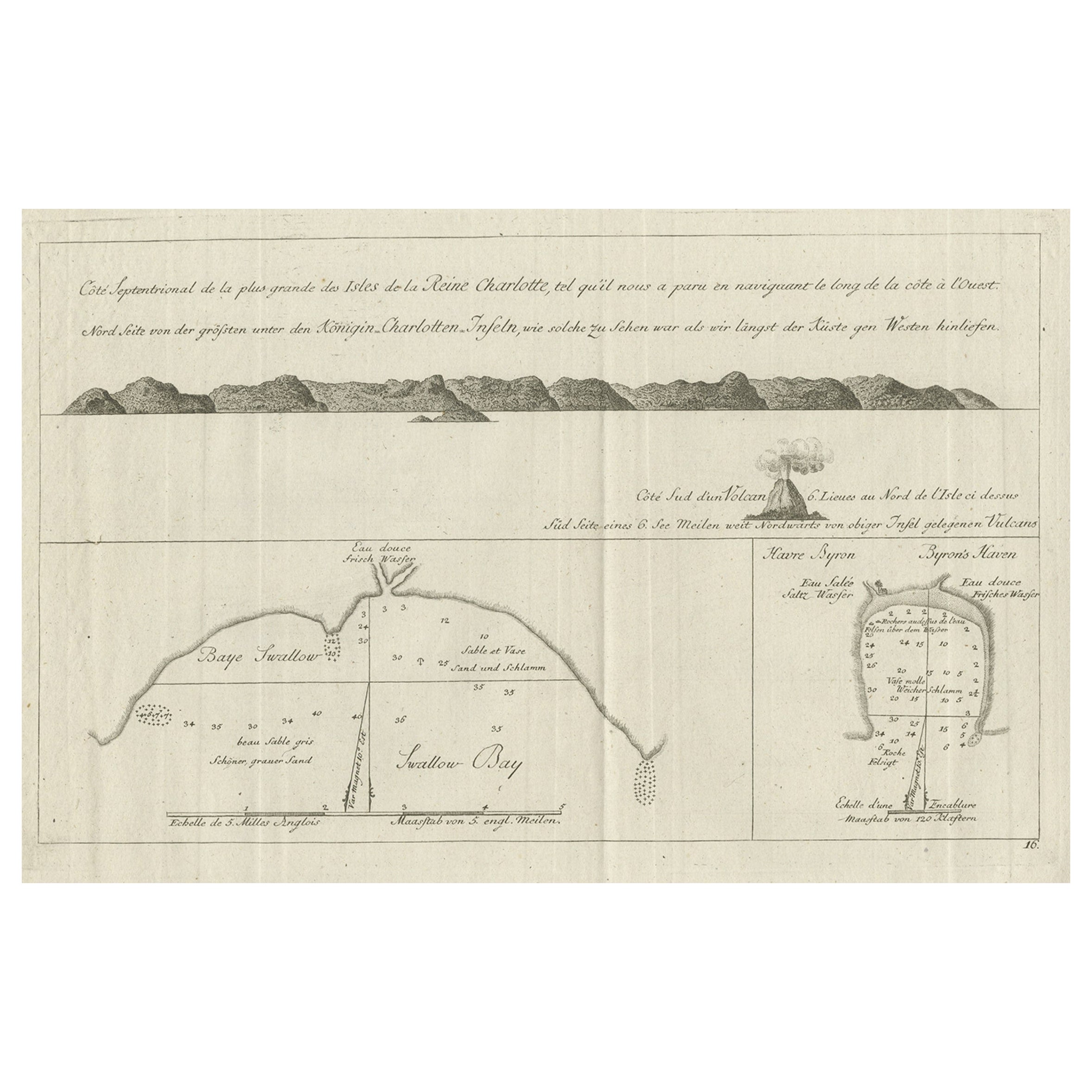
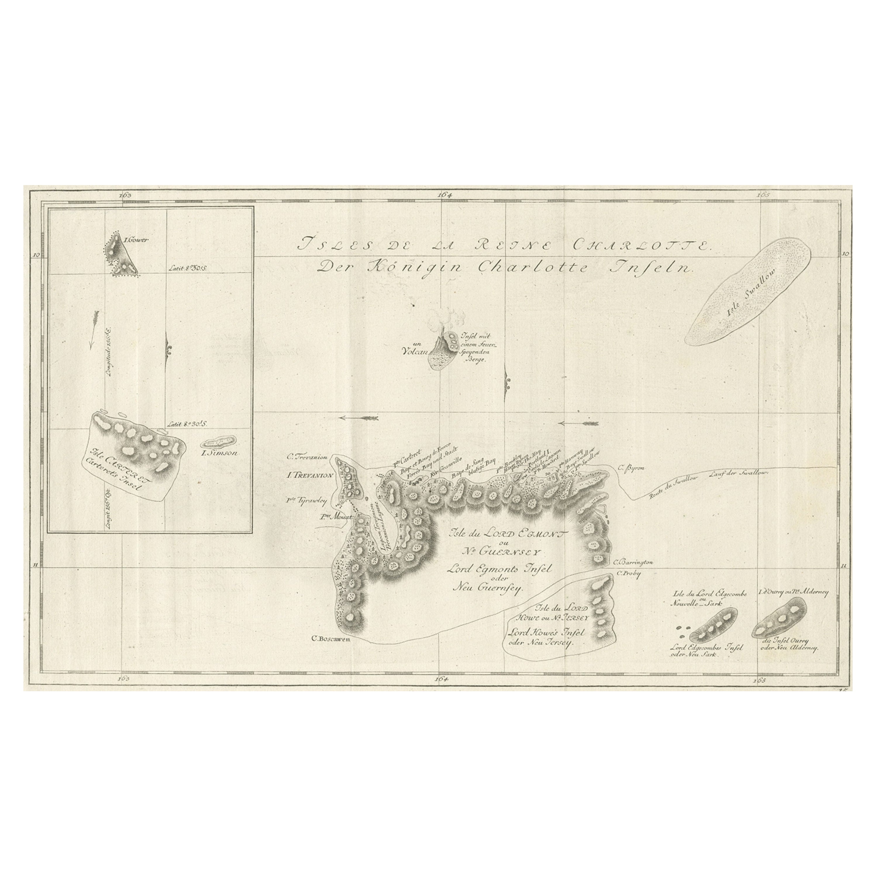
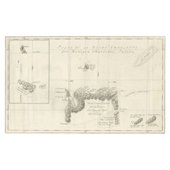
- Old View of the Queen Charlotte's Islands 'Santa Cruz Islands, Solomon', 1774Located in Langweer, NLAntique map titled 'Cote Septentrional de la plus grande des Isles de la Reine Charlotte (..)'. Map and coastal view of the islands within the Queen Charlotte's Islands (Santa Cruz Islands...Category
Antique 1770s Maps
MaterialsPaper
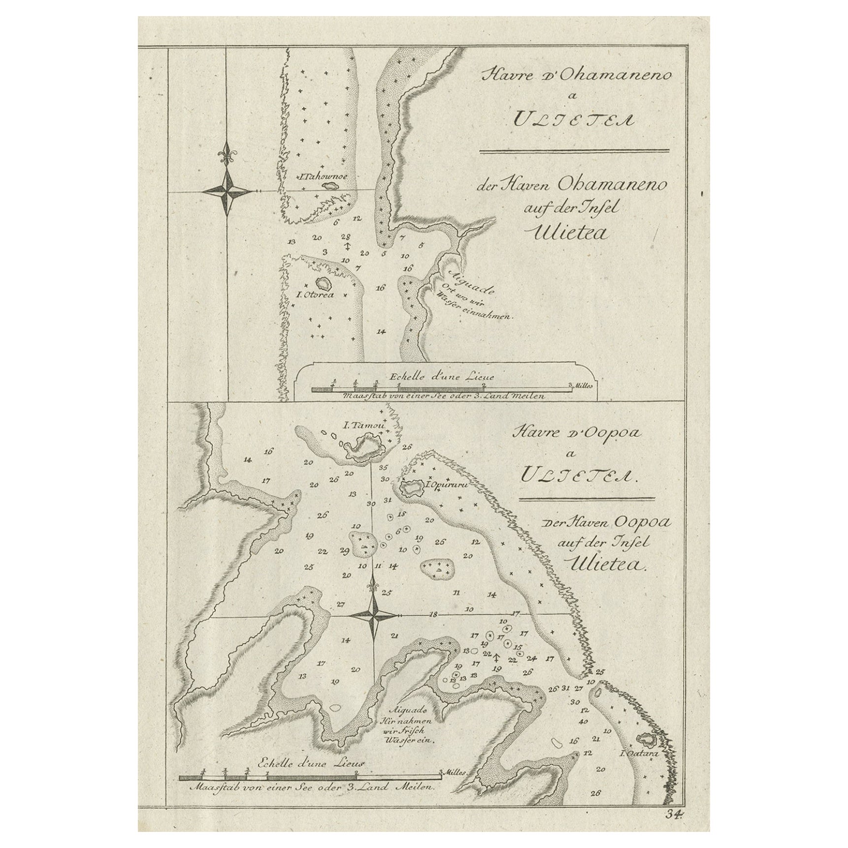
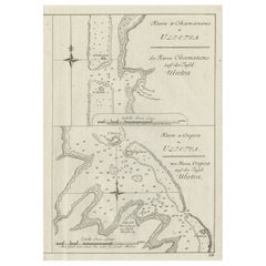
- Antique Print of Various Island in French Polynesia, circa 1774Located in Langweer, NLTwo antique maps on one sheet titled 'Havre d'Ohamaneno a Ulietea' and Havre d'Oopoa a Ulietea'. Also with German subtitles. The upper image depicts Ohamaneno (Vaiaau) Harbour Raiatea (Ulietea) - Leeward Islands...Category
Antique 18th Century Prints
MaterialsPaper
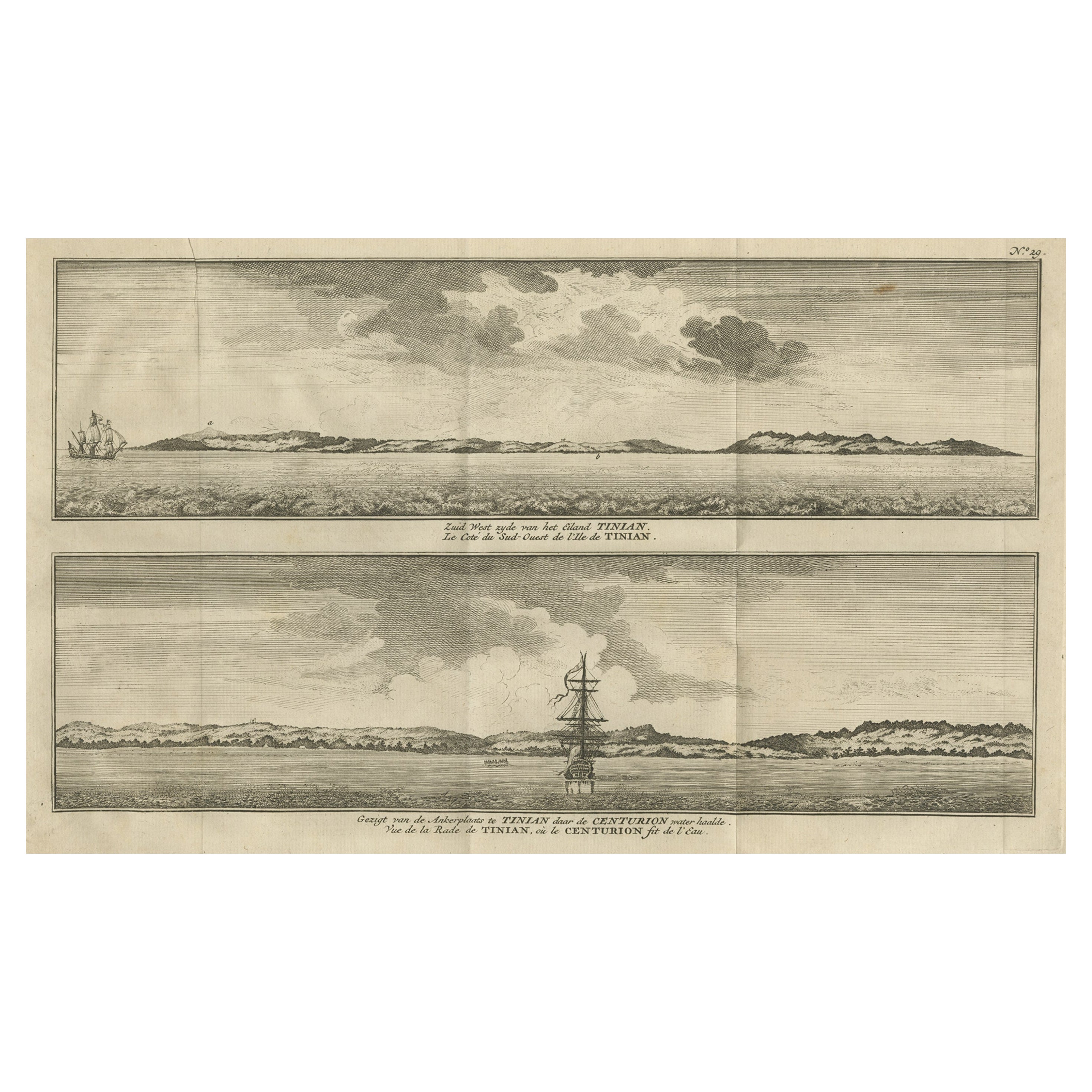
- Antique Print with Views of Tinian Island, the Northern Mariana Islands, 1749Located in Langweer, NLAntique print titled 'Le cote du sud-ouest de l'Ile de Tinian' and 'Vue de la rade de Tinian, ou le Centurion fit de l'eau.' Views of the south-west side of the island of Tinian and a view of the anchorage of Tinian, where the Centurion got water. This print originates from 'Reize rondsom de Werreld (..)' by George Anson, published 1749. Tinian is one of the three principal islands of the Commonwealth of the Northern Mariana Islands...Category
Antique 18th Century Prints
MaterialsPaper
- Original Antique Chart of the Santa Cruz Islands, 1774Located in Langweer, NLAntique print titled 'Isles de la Reine Charlotte (..)'. A detailed chart of the Santa Cruz islands, to the north of the New Hebrides, with Carte...Category
Antique 1770s Maps
MaterialsPaper
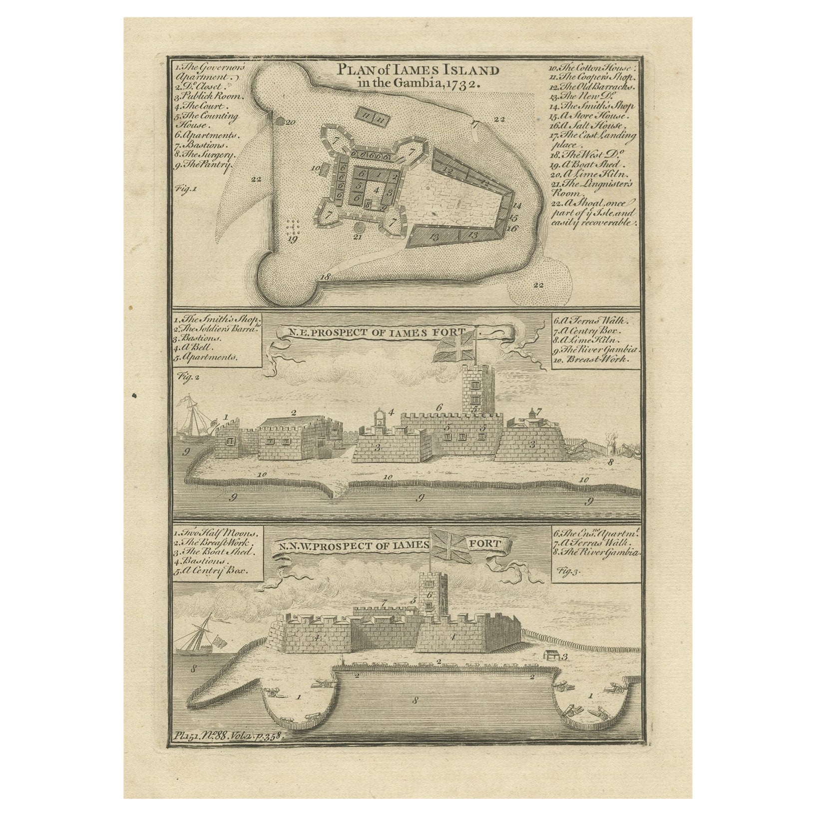
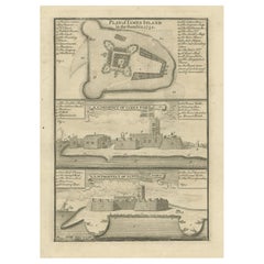
- Antique Print with a Plan of Kunta Kinteh Island and views of Fort James, GambiaLocated in Langweer, NLAntique print titled 'Plan of Iames Island in the Gambia - N.E. Prospect of Iames Fort - N.N.W. Prospect of Iames Fort'. Print with a plan of Kunta Kinteh I...Category
Antique Mid-18th Century Prints
MaterialsPaper
You May Also Like
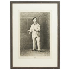
- Sir John Skelton, Charles I.Located in New York, NY1 Volume Bound In 3/4 Tan Morocco, Cloth Boards by Bickers & Son, top edges gilt, raised bands, gilt on spine, royal crest on front cover. Hand-colored Frontispiece. Profusely...Category
Antique 1890s Books
MaterialsLeather
- 1 Volume, Sir John Skelton, Charles I.Located in New York, NY1 Volume. Sir John Skelton, Charles I. Bound in 3/4 red morocco and linen boards double-bordered in gilt tooling. Raised bands, dotted in gilt tooling wit...Category
Antique 19th Century English Books
MaterialsLeather
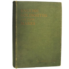
- English Goldsmiths and Their Marks by Sir Charles J. JacksonBy Sir Charles J. JacksonLocated in valatie, NYEnglish Goldsmiths and Their Marks by Sir Charles J. Jackson. London: Macmillan and Co. Ltd., 1921. Second edition hardcover with no dust jacket. 747 pp. A history of goldsmiths and ...Category
20th Century English Books
MaterialsPaper
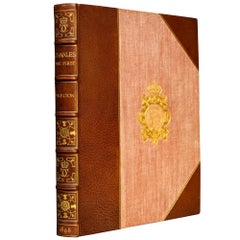
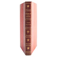
- 1 Volume. Sir John Skelton. Charles The First.Located in New York, NY1 Volume. Sir John Skelton. Charles The First. Bound in full red morocco by Riviere & Son, all edges gilt, raised bands, ornate gilt on spines and covers,...Category
Antique 1890s English Books
MaterialsLeather
- Antique Real Tennis Print, Charles Delahaye, BibocheLocated in Oxfordshire, GBReal tennis print, Charles Delahaye, Biboche, Jeu De Paume, Joueur De Paume. A wonderful rare original 1870s etching of Charles Delahaye, born in 1825 an...Category
Antique Late 19th Century European Sporting Art Prints
MaterialsPaper
- N.E. View of the United States Capitol, Washington, DC Antique Proof Print 1858Located in Colorado Springs, COThis engraved print shows a view of the United States Capitol Building, in Washington, D.C. The print depicts the neoclassical building from the northeast orientation, with a bustling street scene in front. The steel engraving is a proof printing, drawn and engraved by Henry Sartain and published in 1858. Plans began in May 1854 to build a new cast-iron dome for the United States Capitol. The then-architect of the Capitol Thomas Walter and his team were sold on the aesthetics of a new dome, as well as the utility of a fire-proof one. A year later, on March 3, 1855, President Franklin Pierce...Category
Antique 1850s American Prints
MaterialsPaper

Recently Viewed
View AllMore Ways To Browse
Vintage Bartholomews Maps
Old Sicily Map
Antique Maps Of Lithuania
Antique Map Louisiana
Babylon Map
Antique Minnesota Map
Antique Ornamental Map
Jordan Antique Map
La Syrie Antique
Map Lebanon
Map Of Ural
Map Of Washington Dc
Maps Rochester
Queensland Maps
Republic Of Texas Map
Washington Dc Map
Washington Dc Maps
Antique Map Of New Hampshire