Items Similar to Ancient National Atlas of France with Marengo

Want more images or videos?
Request additional images or videos from the seller
1 of 14
Ancient National Atlas of France with Marengo
$745.40
$931.7520% Off
£564.66
£705.8220% Off
€640
€80020% Off
CA$1,032.66
CA$1,290.8220% Off
A$1,158.19
A$1,447.7420% Off
CHF 606.53
CHF 758.1620% Off
MX$14,073.15
MX$17,591.4420% Off
NOK 7,701.88
NOK 9,627.3420% Off
SEK 7,301.92
SEK 9,127.4020% Off
DKK 4,872.81
DKK 6,091.0120% Off
About the Item
Ancient National Atlas of France with the department of Marengo: a rare French etching dated 1806.
ST/178.
- Dimensions:Height: 17.13 in (43.5 cm)Width: 24.02 in (61 cm)Depth: 0.04 in (1 mm)
- Style:Other (In the Style Of)
- Materials and Techniques:Paper,Engraved
- Place of Origin:
- Period:
- Date of Manufacture:1806
- Condition:
- Seller Location:Alessandria, IT
- Reference Number:Seller: ST/1781stDibs: LU1379244493932
About the Seller
4.9
Vetted Professional Seller
Every seller passes strict standards for authenticity and reliability
Established in 1984
1stDibs seller since 2015
366 sales on 1stDibs
Typical response time: 12 hours
- ShippingRetrieving quote...Shipping from: Alessandria, Italy
- Return Policy
Authenticity Guarantee
In the unlikely event there’s an issue with an item’s authenticity, contact us within 1 year for a full refund. DetailsMoney-Back Guarantee
If your item is not as described, is damaged in transit, or does not arrive, contact us within 7 days for a full refund. Details24-Hour Cancellation
You have a 24-hour grace period in which to reconsider your purchase, with no questions asked.Vetted Professional Sellers
Our world-class sellers must adhere to strict standards for service and quality, maintaining the integrity of our listings.Price-Match Guarantee
If you find that a seller listed the same item for a lower price elsewhere, we’ll match it.Trusted Global Delivery
Our best-in-class carrier network provides specialized shipping options worldwide, including custom delivery.More From This Seller
View AllGeographical Antique Map of Principality of Monaco
By Bruno Santini
Located in Alessandria, Piemonte
ST/609 - Interesting antique color map of Monaco Principality in French language : "Carte qui contient le Principauté de Piémont, le Monferrat et la comté de...
Category
Antique Late 18th Century Italian Other Maps
Materials
Paper

$801 Sale Price
20% Off
Old Horizontal Map of England
By Tasso
Located in Alessandria, Piemonte
ST/520 - Old rare Italian map of England, dated 1826-1827 - by Girolamo Tasso, editor in Venise, for the atlas of M.r Le-Sage.
Category
Antique Early 19th Century Italian Other Prints
Materials
Paper

Antique Map of Principality of Monaco
By Antonio Vallardi Editore
Located in Alessandria, Piemonte
ST/619 - "Old Geographical Atlas of Italy - Topographic map of ex-Principality of Monaco" -
ediz Vallardi - Milano -
A somewhat special edition ---
Category
Antique Late 19th Century Italian Other Prints
Materials
Paper

$354 Sale Price
62% Off
Geographical Map of Italy
Located in Alessandria, Piemonte
BOLIS Publishing House - Bergamo.
A beautiful large map of Italy, on paper but suitably reinforced to preserve it correctly. The maps were usually p...
Category
Mid-20th Century Italian Other Prints
Materials
Paper

$931 Sale Price
20% Off
Map "Estuary- Mouth of the Thames"
Located in Alessandria, Piemonte
ST/426 - Antique French Map of the estuary of the Thames, map dated 1769 -
"Mape of the entrance of the Thames. Designed by filing of Navy cards fo...
Category
Antique Mid-18th Century French Other Prints
Materials
Paper

$1,024 Sale Price
20% Off
Ancient Valenza Jewelry City Etching
Located in Alessandria, Piemonte
Ancient etching from 1707 representing VALENZA, the Italian city in the province of Alessandria, famous throughout the world for its gold processing any jewelry factories.
Author of ...
Category
Antique Early 18th Century Italian Other Prints
Materials
Paper
$1,351 Sale Price
20% Off
You May Also Like
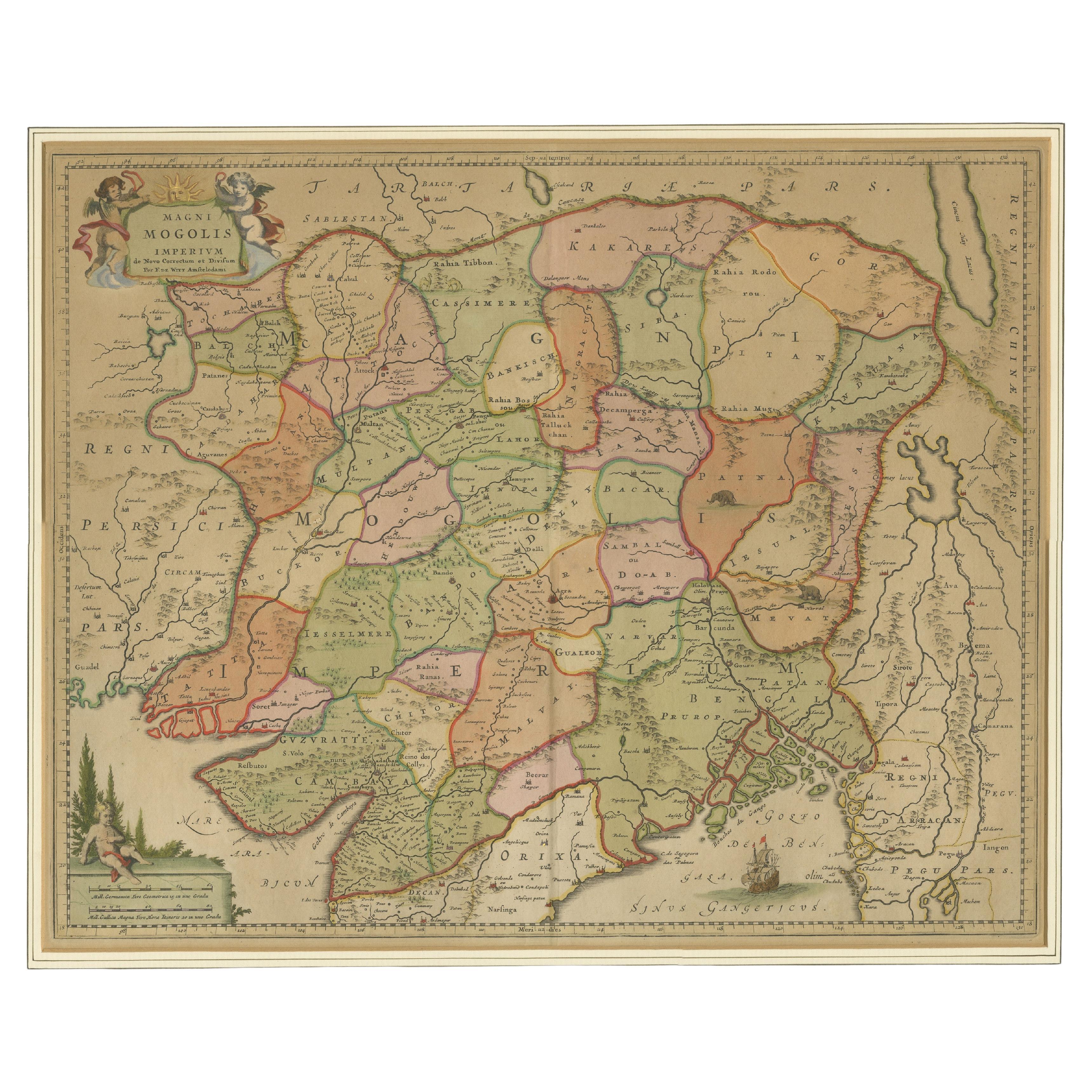
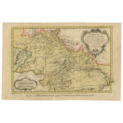
Antique Map of the Empire of the Great Mogul
Located in Langweer, NL
Antique map titled 'Magni Mogolis Imperium'. This map depicts the Empire of the Great Mogul in northern India including the region from Iran to Burma. The Indus and Ganges Rivers are...
Category
Antique Late 17th Century Maps
Materials
Paper
$894 Sale Price
20% Off
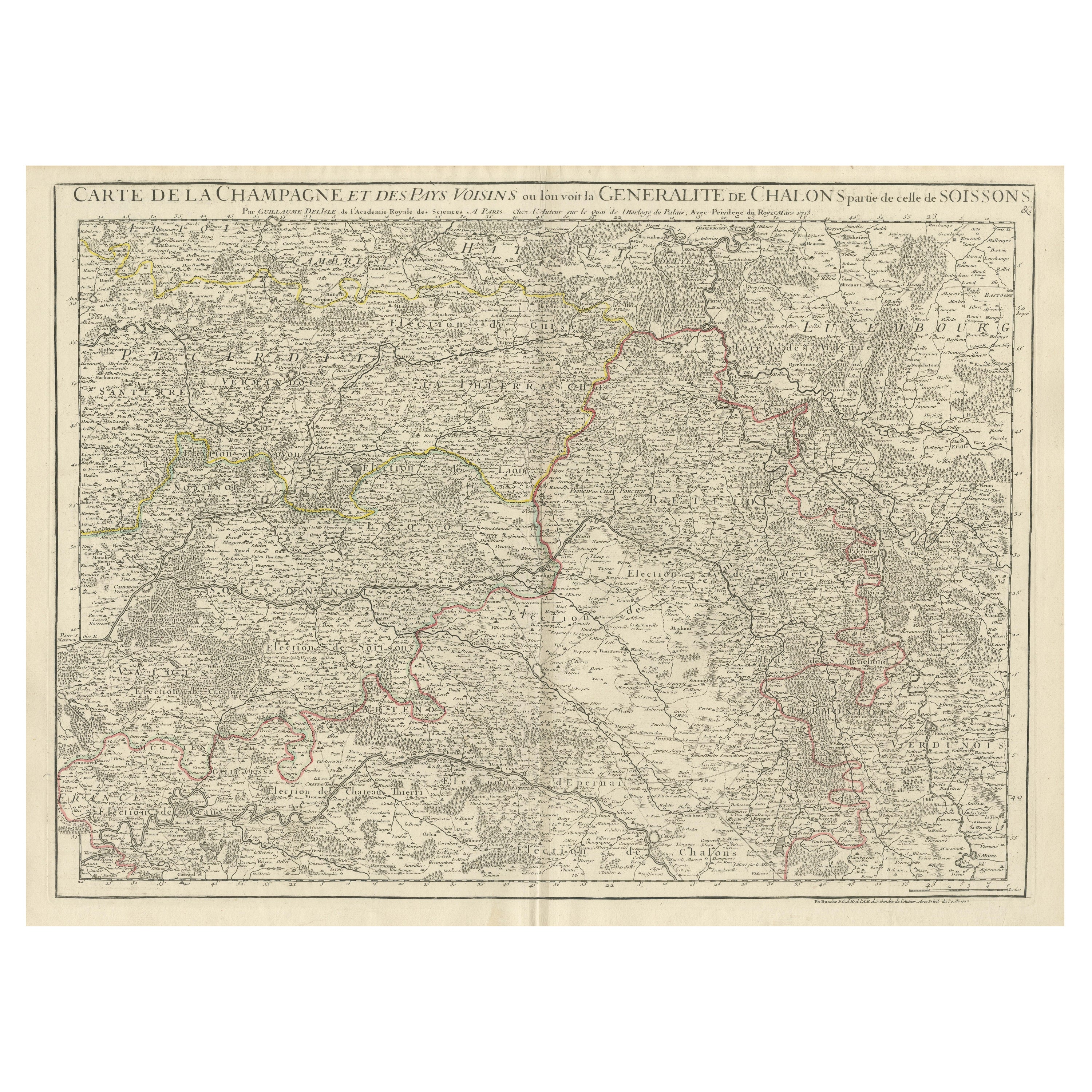
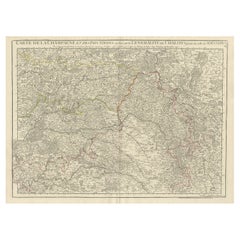
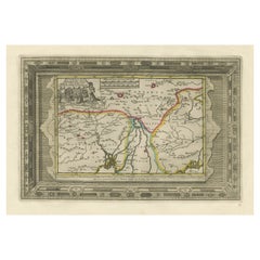
Antique Map of Champagne and surrounding Regions, France
Located in Langweer, NL
Antique map titled 'Carte de la Champagne et des Pays Voisins (..)'. Detailed map of Champagne and surrounding regions of Chalons and Soissons, Reims,...
Category
Antique Mid-18th Century Maps
Materials
Paper
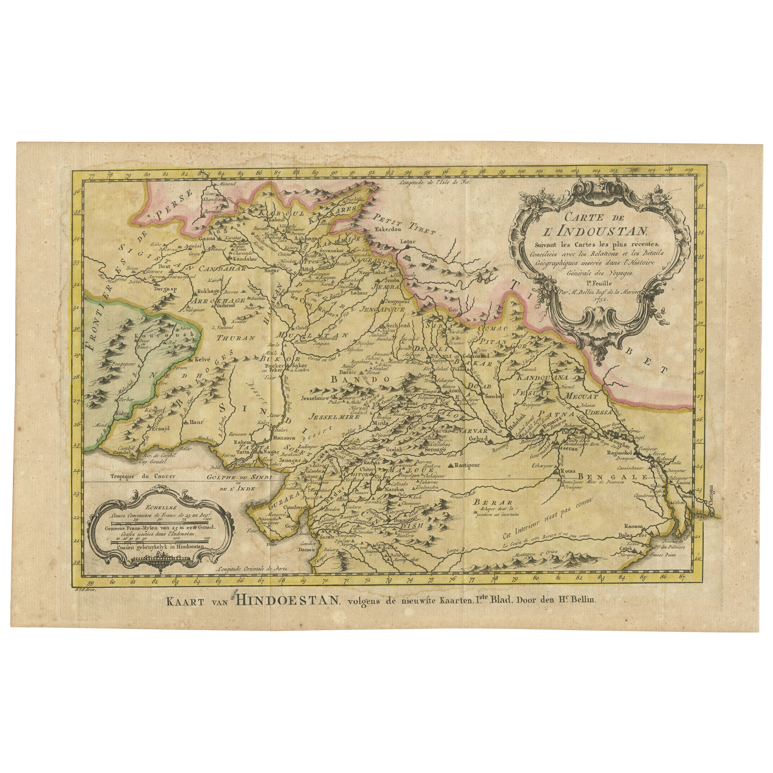
Original Antique Map of Northern India
By Jakob van der Schley
Located in Langweer, NL
Antique map titled 'Carte de l'Indoustan (..) - Kaart van Hindoestan (..)'. Original antique map of northern India. This map originates from 'His...
Category
Antique Mid-18th Century Maps
Materials
Paper
$204 Sale Price
20% Off
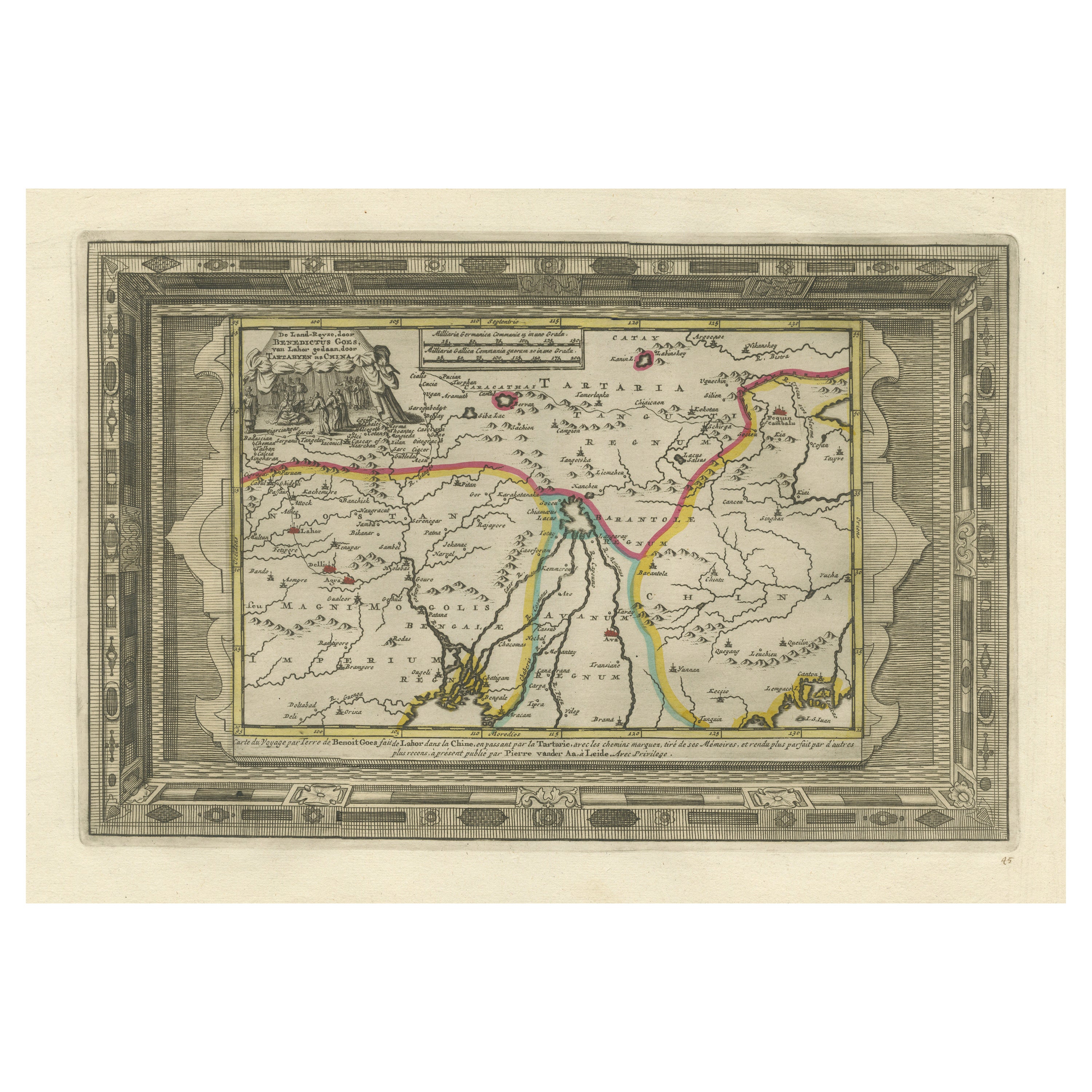
Benedictus Goes’ Route – Antique Map of Tartary to China by Van der Aa, 1714
Located in Langweer, NL
Benedictus Goes’ Route – Antique Map of Tartary to China by Van der Aa, 1714
This fascinating antique map titled De Land-Reyse door Benedictus Goes, van Lahor gedaan, door Tartaryen...
Category
Antique Early 18th Century Dutch Maps
Materials
Paper
$503 Sale Price
20% Off
Antique Map of Algeria and the French Colonies, 1875
Located in Langweer, NL
Antique map titled 'Algérie et Colonies Francaises'. Large map of Algeria and the French Colonies. This map originates from 'Atlas de Géographie Moderne Physique et Politique' by A. ...
Category
Antique Late 19th Century French Maps
Materials
Paper

$302 Sale Price
35% Off
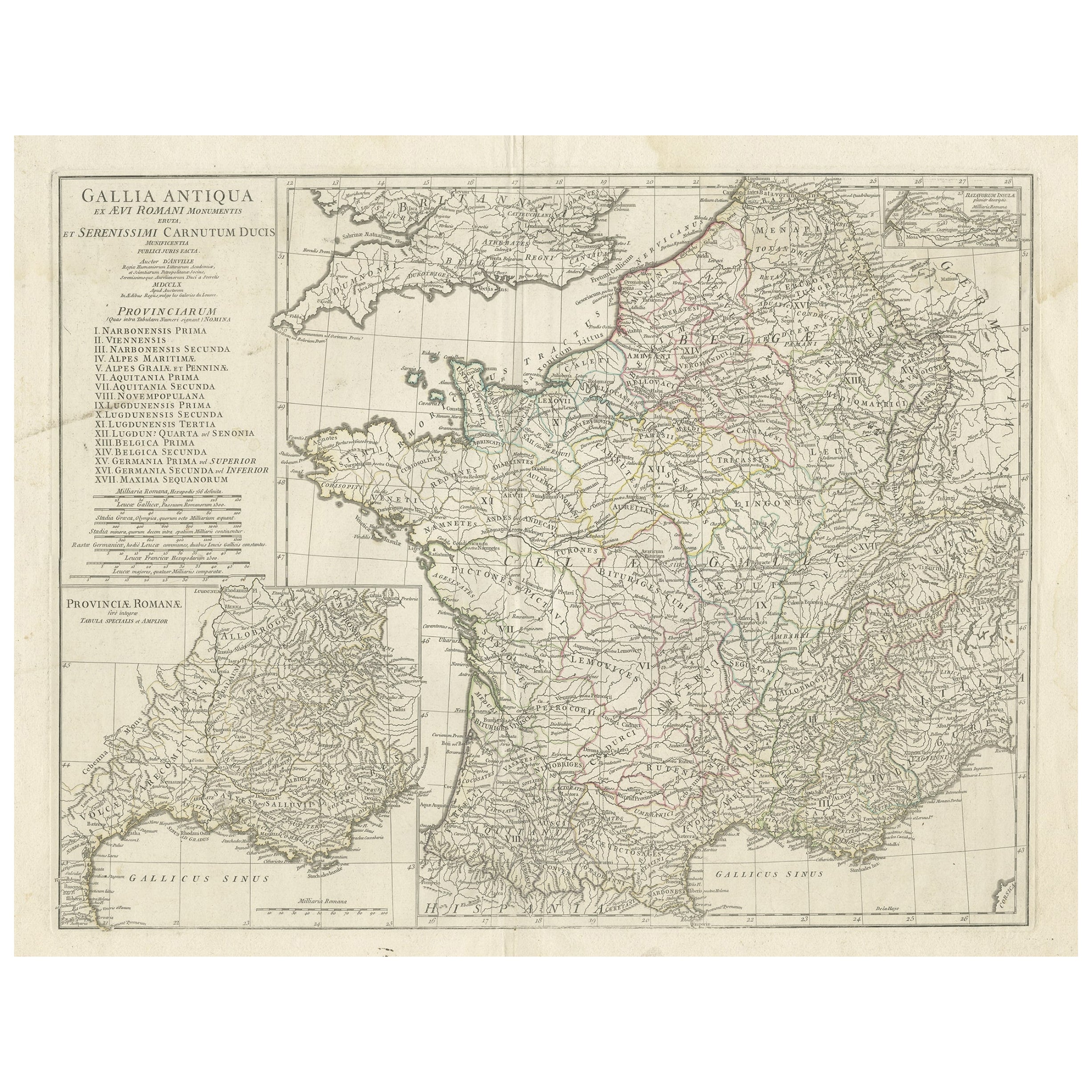
Large Antique Map of Gaul, or France in Ancient Roman Times, circa 1760
Located in Langweer, NL
Original antique map titled 'Gallia Antiqua ex Aevi Romani Monumentis (..)'. Large map of Gaul, or France in ancient Roman times, showing Roman provinces. Inset bottom left a detaile...
Category
Antique Mid-18th Century French Maps
Materials
Paper
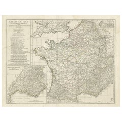
$437 Sale Price
20% Off
More Ways To Browse
Antique Flip Glass
Antique French Large Urn Porcelain
Antique Galvanized Metal
Antique Heywood Wakefield Chairs
Antique Hudson Bay
Antique Large Green Glass Bottle
Antique Lunettes
Antique Medical Cabinets
Antique Mortise Lock
Antique Norwegian Cabinet
Antique Pantry Box
Antique Pot Belly
Antique Sandalwood Box
Antique Seafoam Green
Antique Secretary Desk With Display
Antique Sink Vanity
Antique Spindle Beds
Antique Staffordshire Lions