Items Similar to Antique Chart of CAP Providence and Other Charts by Hawkesworth, 1774

Want more images or videos?
Request additional images or videos from the seller
1 of 6
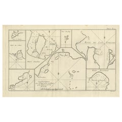
Antique Chart of CAP Providence and Other Charts by Hawkesworth, 1774
$306.72
$383.4120% Off
£228.29
£285.3720% Off
€256
€32020% Off
CA$420.14
CA$525.1720% Off
A$467.28
A$584.1020% Off
CHF 244
CHF 30520% Off
MX$5,686.34
MX$7,107.9220% Off
NOK 3,116.26
NOK 3,895.3320% Off
SEK 2,922.50
SEK 3,653.1320% Off
DKK 1,948.84
DKK 2,436.0520% Off
Shipping
Retrieving quote...The 1stDibs Promise:
Authenticity Guarantee,
Money-Back Guarantee,
24-Hour Cancellation
About the Item
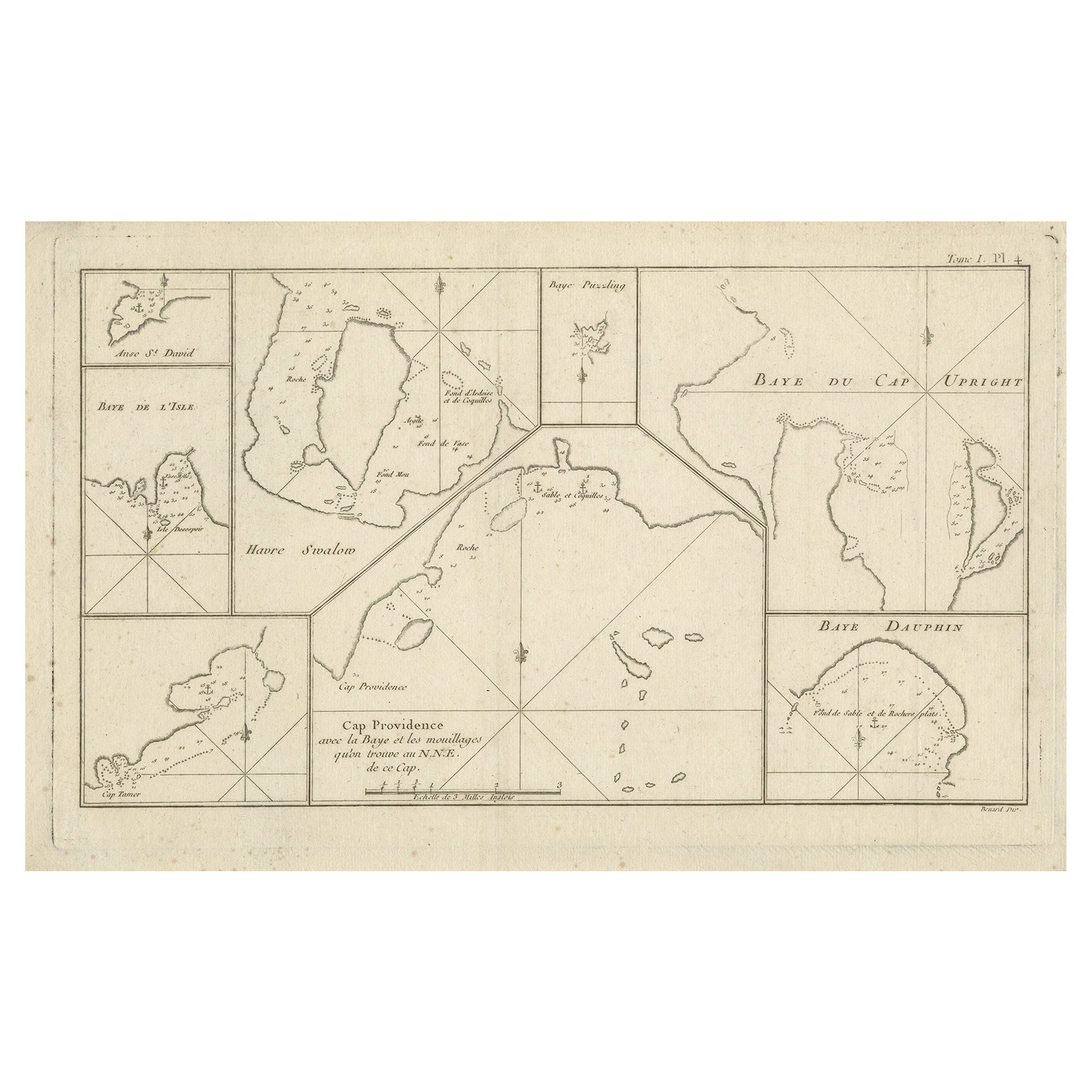
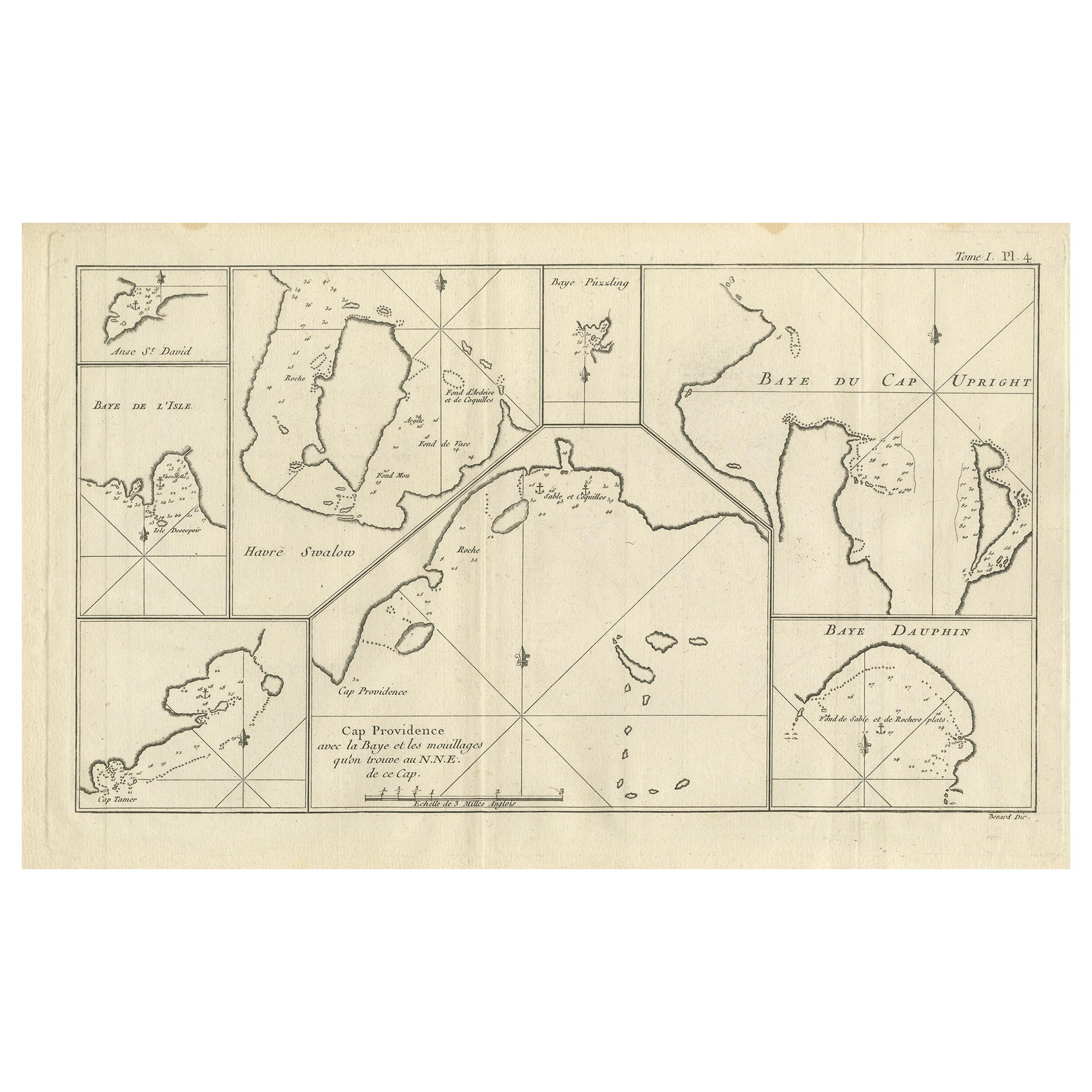
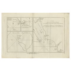
Antique print titled 'Baye du Cap Upright (..)'. Eight charts on one sheet of Cap Providence, St. David's Cove, the Bay of the Island, Swallow's Haven, Puzzling Bay, Baye du Cape Upright 's Bay, Dauphina's Bay. Originates from 'Geschichte der See-Reisen und Entdeckungen im Süd-Meer welche auf Befehl Sr. Großbrittanischen Majestät unternommen, und von Commodore Byron, Capitain Wallis, Capitain Carteret und Capitain Coockim Dolphin, der Swallow, und dem Endeavour nach einander ausgeführt worden sind (..)'.
Artists and Engravers: Published by Haude & Spener, Berlin.
Condition: Very good, general age-related toning. Please study image carefully.
Date: 1774
Overall size: 38.5 x 26 cm.
Image size: 35.5 x 20.5 cm.
Antique prints have long been appreciated for both their aesthetic and investment value. They were the product of engraved, etched or lithographed plates. These plates were handmade out of wood or metal, which required an incredible level of skill, patience and craftsmanship. Whether you have a house with Victorian furniture or more contemporary decor an old engraving can enhance your living space. We offer a wide range of authentic antique prints for any budget.
- Dimensions:Height: 10.24 in (26 cm)Width: 15.16 in (38.5 cm)Depth: 0 in (0.01 mm)
- Materials and Techniques:
- Period:
- Date of Manufacture:1774
- Condition:Condition: Very good, general age-related toning. Please study image carefully.
- Seller Location:Langweer, NL
- Reference Number:Seller: BGJC-2191stDibs: LU3054329623962
About the Seller
5.0
Recognized Seller
These prestigious sellers are industry leaders and represent the highest echelon for item quality and design.
Platinum Seller
Premium sellers with a 4.7+ rating and 24-hour response times
Established in 2009
1stDibs seller since 2017
2,502 sales on 1stDibs
Typical response time: <1 hour
- ShippingRetrieving quote...Shipping from: Langweer, Netherlands
- Return Policy
Authenticity Guarantee
In the unlikely event there’s an issue with an item’s authenticity, contact us within 1 year for a full refund. DetailsMoney-Back Guarantee
If your item is not as described, is damaged in transit, or does not arrive, contact us within 7 days for a full refund. Details24-Hour Cancellation
You have a 24-hour grace period in which to reconsider your purchase, with no questions asked.Vetted Professional Sellers
Our world-class sellers must adhere to strict standards for service and quality, maintaining the integrity of our listings.Price-Match Guarantee
If you find that a seller listed the same item for a lower price elsewhere, we’ll match it.Trusted Global Delivery
Our best-in-class carrier network provides specialized shipping options worldwide, including custom delivery.More From This Seller
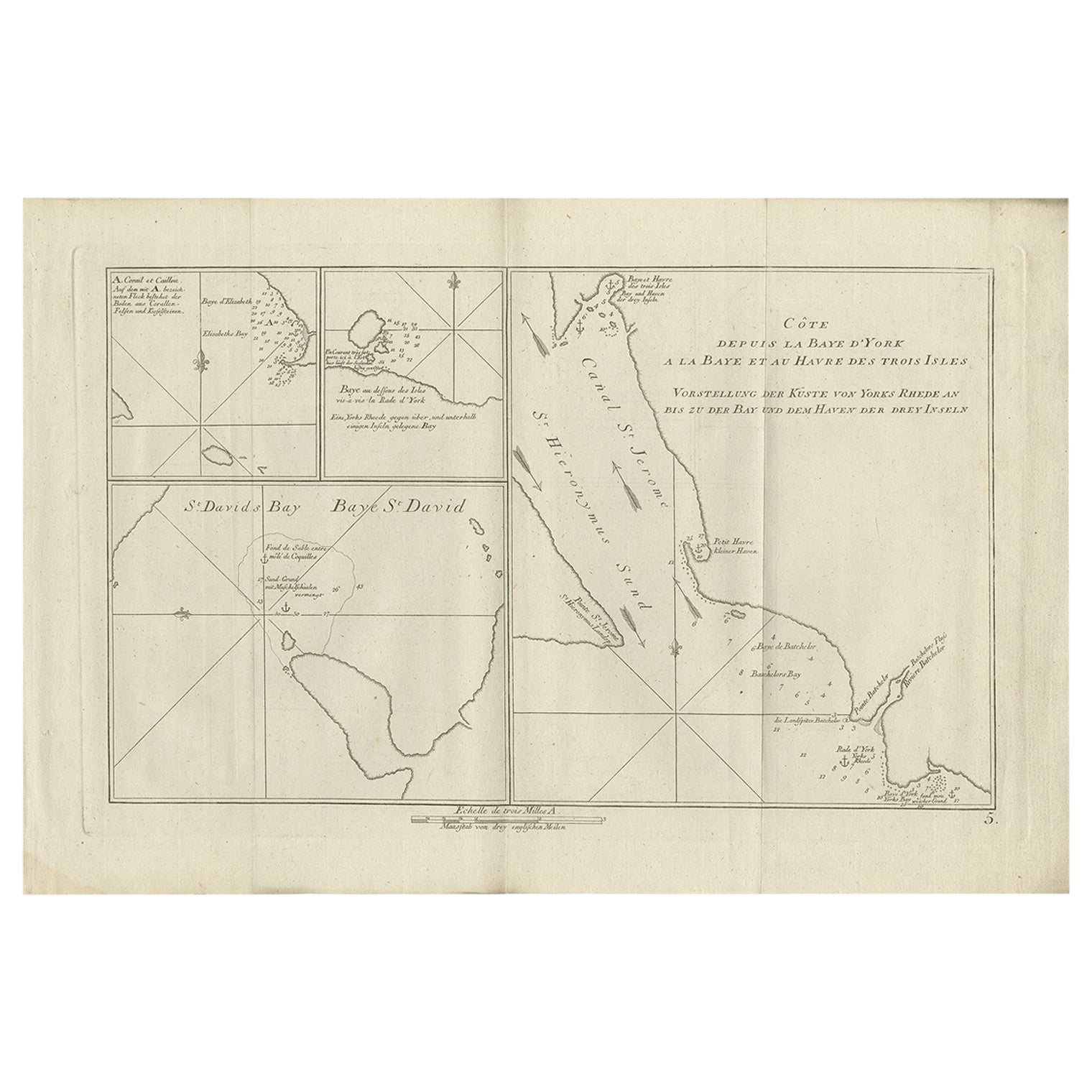
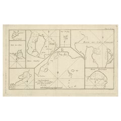
View AllAntique Chart of York's Bay and Surroundings by Hawkesworth, 1774
Located in Langweer, NL
Antique print titled 'Baye St. David (..)'. Charts of York's Bay, Haven of the Three Islands, St. David's Bay, and Elizabeth's Bay. Originates from 'Geschichte der See-Reisen und Ent...
Category
Antique 18th Century Prints
Materials
Paper
$277 Sale Price
20% Off
Antique Map of CAP Providence, St. David's Cove and Surroundings
Located in Langweer, NL
Antique map titled 'Baye du Cap Upright (..)'. Eight charts on one sheet of Cap Providence, St. David's Cove, the Bay of the Island, Swallow's Haven, Puzzlin...
Category
Antique Late 18th Century Maps
Materials
Paper
$345 Sale Price
20% Off
Antique Map of New Ireland, 1774
Located in Langweer, NL
Antique print titled 'Neu Irrland (..)'. Antique map of New Ireland with 7 coastal profiles, Papua New Guinea. Originates from 'Geschichte der See-Reisen u...
Category
Antique 18th Century Maps
Materials
Paper

$277 Sale Price
20% Off
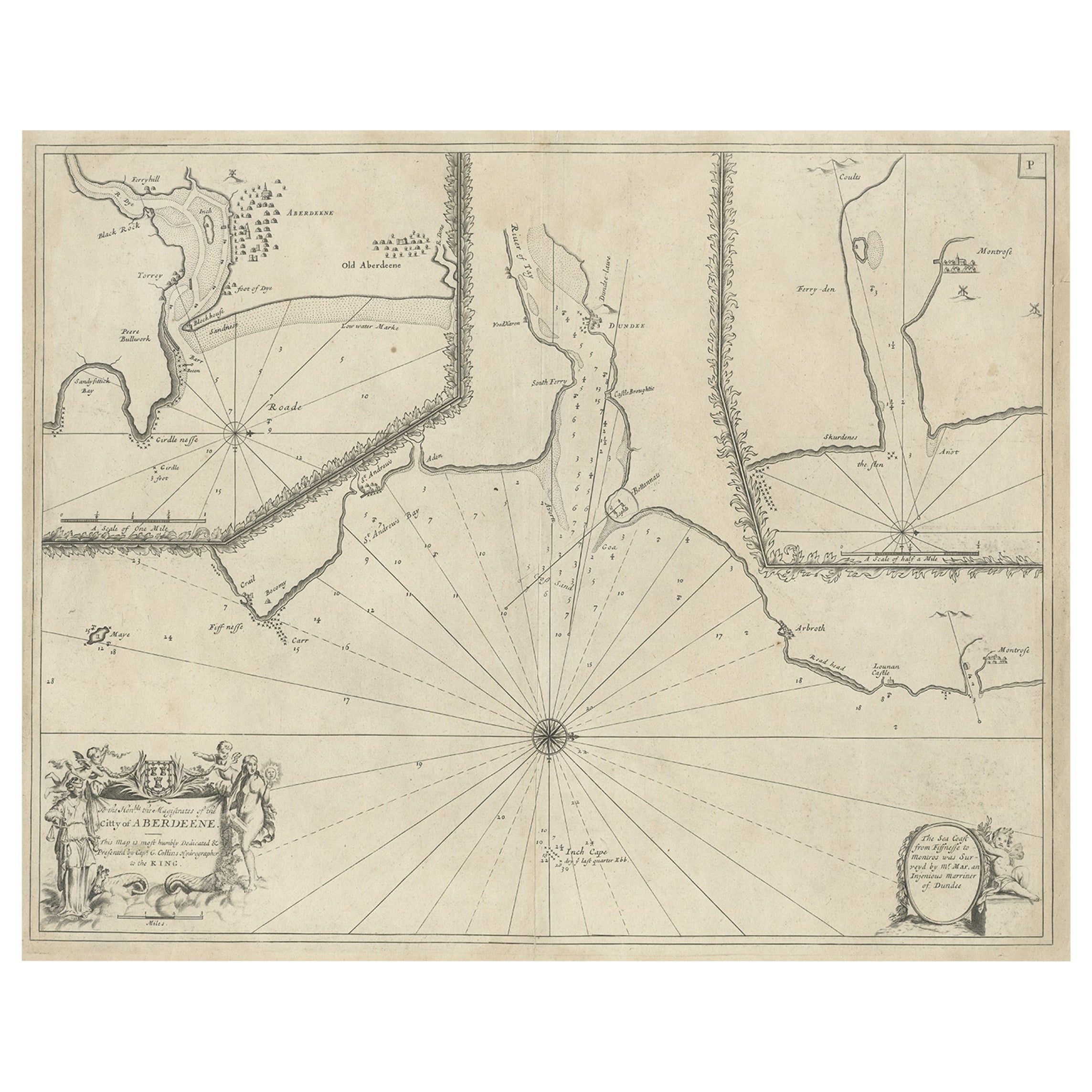
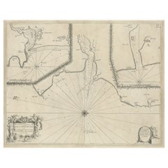
Antique Chart of Dundee, Aberdeen and Montrose in Scotland, C.1774
By Captain Greenvile Collins
Located in Langweer, NL
Antique map titled 'To the Honble the Magistrates of the Citty of Aberdeene'. Sea chart of Tay Estuary depictinging Dundee, with two further inset charts of Aberdeen and Montrose, wi...
Category
Antique 18th Century Maps
Materials
Paper
$258 Sale Price
20% Off
Antique Map of Cap Providence, St. David's Cove and Surroundings
Located in Langweer, NL
Antique map titled 'Baye du Cap Upright (..)'. Eight charts on one sheet of Cap Providence, St. David's Cove, the Bay of the Island, Swallow's Haven, Puzzlin...
Category
Antique Late 18th Century Maps
Materials
Paper
$345 Sale Price
20% Off
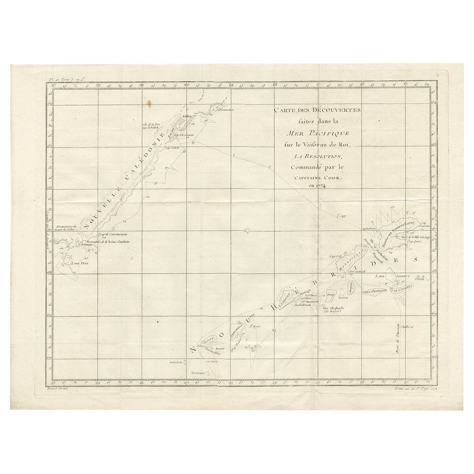
Antique Chart of the Voyage of Captain Cook by Benard, 1780
Located in Langweer, NL
Antique map titled 'Carte des Découvertes faites dans la Mer Pacifique sur la Vaisse au de Roi, La Resolution, Commandé par le Capitaine Cook en 1774'. Chart detailing the 1774 voyag...
Category
Antique 18th Century Maps
Materials
Paper
$268 Sale Price
20% Off
You May Also Like
Dartmouth, England: A Hand-Colored 17th Century Sea Chart by Captain Collins
By Captain Greenvile Collins
Located in Alamo, CA
This hand-colored sea chart of the area around Dartmouth, England is from "Great Britain's Coasting Pilot. Being a New and Exact Survey of the Sea-Coast of England", first published ...
Category
Antique Late 17th Century English Maps
Materials
Paper

Antique Maritime Chart of East Coast Virginia to Nova Scotia
Located in Norwell, MA
1920 nautical chart of the East Coast of the United States from Virginia to Maine, New Brunswick, and Nova Scotia. The chart shows Cape Cod, Long Island, the Connecticut coast, Jersey Shore, Maine, New Hampshire, etc. Very detailed, showing ports, lighthouses, shoals, depths, etc. The chart is by famous cartographer George W. Eldridge, compiled from surveys of the United States government, British Admiralty, George Eldridge, and others. First authorized by George Eldridge, published in 1916 by Wilfred O. White with a merchant's stamp of Charles Hutchinson...
Category
Vintage 1920s North American Maps
Materials
Paper

Original Antique Map of Switzerland, Engraved By Barlow, Dated 1807
Located in St Annes, Lancashire
Great map of Switzerland
Copper-plate engraving by Barlow
Published by Brightly & Kinnersly, Bungay, Suffolk.
Dated 1807
Unframed.
Category
Antique Early 1800s English Maps
Materials
Paper

Plymouth, England: A Hand-Colored 17th Century Sea Chart by Captain Collins
By Captain Greenvile Collins
Located in Alamo, CA
This hand-colored sea chart of the area around Plymouth, England from "Great Britain's Coasting Pilot. Being a New and Exact Survey of the Sea-Coast of England", first published in 1...
Category
Antique Late 17th Century English Maps
Materials
Paper

Rare 18th C. Newport Map
Located in Sandwich, MA
Rare 18th C, Map titled "A plan of the town of Newport in the province of Rhode Island". Earliest printed plan of Newport, published for the use of the British just prior to their o...
Category
Antique 1770s American Maps
Materials
Paper

$19,500 / item
English Engraved Hand Colored Map of the North Eastern United States, circa 1817
Located in Charleston, SC
English copper engraved hand colored map of the North Eastern United States matted under glass in a gilt frame, Early 19th Century. Drawn and Engraved for Thomson's New General Atlas...
Category
Antique 1810s English George III Maps
Materials
Glass, Giltwood, Paint, Paper

More Ways To Browse
Antique Wood Puzzle
Striped Cabinets
Sugar Cabinet
Swedish Gustavian Antiques
Tall Blanket Chest
Tambour Marble
Tapio Leaf
Tapio Wirkkala Leaf
Teak King Bed
Teapot Vintage Porcelain China
Terracotta Dogs
Thangka Art
Tibetan Metal Art
Tiffany Bell
Tiffany Venetian
Tree Stump Dining Table
Tree Trunk Hollow
Tsar Imperial