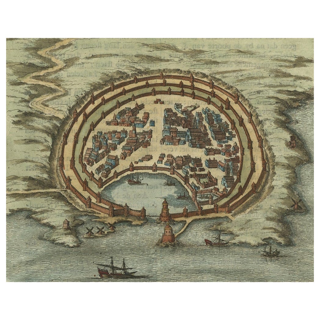
Items Similar to Antique Engravings, One Sheet with 3 Bird's Eye Plans of Rhodes, Greece, 1677

Want more images or videos?
Request additional images or videos from the seller
1 of 5
Antique Engravings, One Sheet with 3 Bird's Eye Plans of Rhodes, Greece, 1677
$407.37
$509.2120% Off
£303.26
£379.0720% Off
€340
€42520% Off
CA$557.99
CA$697.4920% Off
A$620.61
A$775.7620% Off
CHF 324.06
CHF 405.0820% Off
MX$7,552.17
MX$9,440.2120% Off
NOK 4,138.79
NOK 5,173.4820% Off
SEK 3,881.45
SEK 4,851.8120% Off
DKK 2,588.30
DKK 3,235.3820% Off
Shipping
Retrieving quote...The 1stDibs Promise:
Authenticity Guarantee,
Money-Back Guarantee,
24-Hour Cancellation
About the Item
Antique map, titled: 'Afbeelding der Oude Stad Rhodus (…).' - Sheet with 3 bird's eye plans of Rhodes, Greece.
Source unknown, to be determined.
Artists and Engravers: Made by 'Olfert Dapper' after an anonymous artist. Made by 'Olfert Dapper' after an anonymous artist. Olfert Dapper (c. 1635 - 1689) was a Dutch physician and writer. He wrote books about history and geography, although he never travelled outside Holland. Until today, his book Description of Africa (1668) is a key text for Africanists.
Technic: Engraving / etching on hand laid (verge) paper.
Condition: Good, given age. A few minor crinkles. Original folds as issued. General age-related toning and/or occasional minor defects from handling. Please study scan carefully.
Date: 1677
Overall size: 15.6 x 12 inch
Image size: 0.001 x 13.7 x 10.7 inch.
- Dimensions:Height: 12 in (30.48 cm)Width: 15.6 in (39.63 cm)Depth: 0.001 in (0.03 mm)
- Materials and Techniques:
- Period:
- Date of Manufacture:1677
- Condition:
- Seller Location:Langweer, NL
- Reference Number:Seller: PCT-614421stDibs: LU3054325634732
About the Seller
5.0
Recognized Seller
These prestigious sellers are industry leaders and represent the highest echelon for item quality and design.
Platinum Seller
Premium sellers with a 4.7+ rating and 24-hour response times
Established in 2009
1stDibs seller since 2017
2,508 sales on 1stDibs
Typical response time: <1 hour
- ShippingRetrieving quote...Shipping from: Langweer, Netherlands
- Return Policy
Authenticity Guarantee
In the unlikely event there’s an issue with an item’s authenticity, contact us within 1 year for a full refund. DetailsMoney-Back Guarantee
If your item is not as described, is damaged in transit, or does not arrive, contact us within 7 days for a full refund. Details24-Hour Cancellation
You have a 24-hour grace period in which to reconsider your purchase, with no questions asked.Vetted Professional Sellers
Our world-class sellers must adhere to strict standards for service and quality, maintaining the integrity of our listings.Price-Match Guarantee
If you find that a seller listed the same item for a lower price elsewhere, we’ll match it.Trusted Global Delivery
Our best-in-class carrier network provides specialized shipping options worldwide, including custom delivery.More From This Seller
View AllAntique Engraving with a Plan of Rhodes, Greece, 1688
Located in Langweer, NL
Description: Antique map, titled: 'Rhodos.' - Plan of Rhodes, Greece. This map originates from 'Nauwkeurige Beschrijving der eilanden in de in de Archipel der Middellantsche Zee', by...
Category
Antique 1680s Maps
Materials
Paper
$431 Sale Price
20% Off
Spectacular Antique Original Engraving of a Town Plan of Jerusalem, 1708
Located in Langweer, NL
Description: Antique map titled 'Erster Abriss der Stadt Jerusalem wie sie Furnemblich zur Zeit des Hernn Christi beschaffen (..).'
Spectacular town plan...
Category
Antique Early 1700s Maps
Materials
Paper

$1,294 Sale Price
20% Off
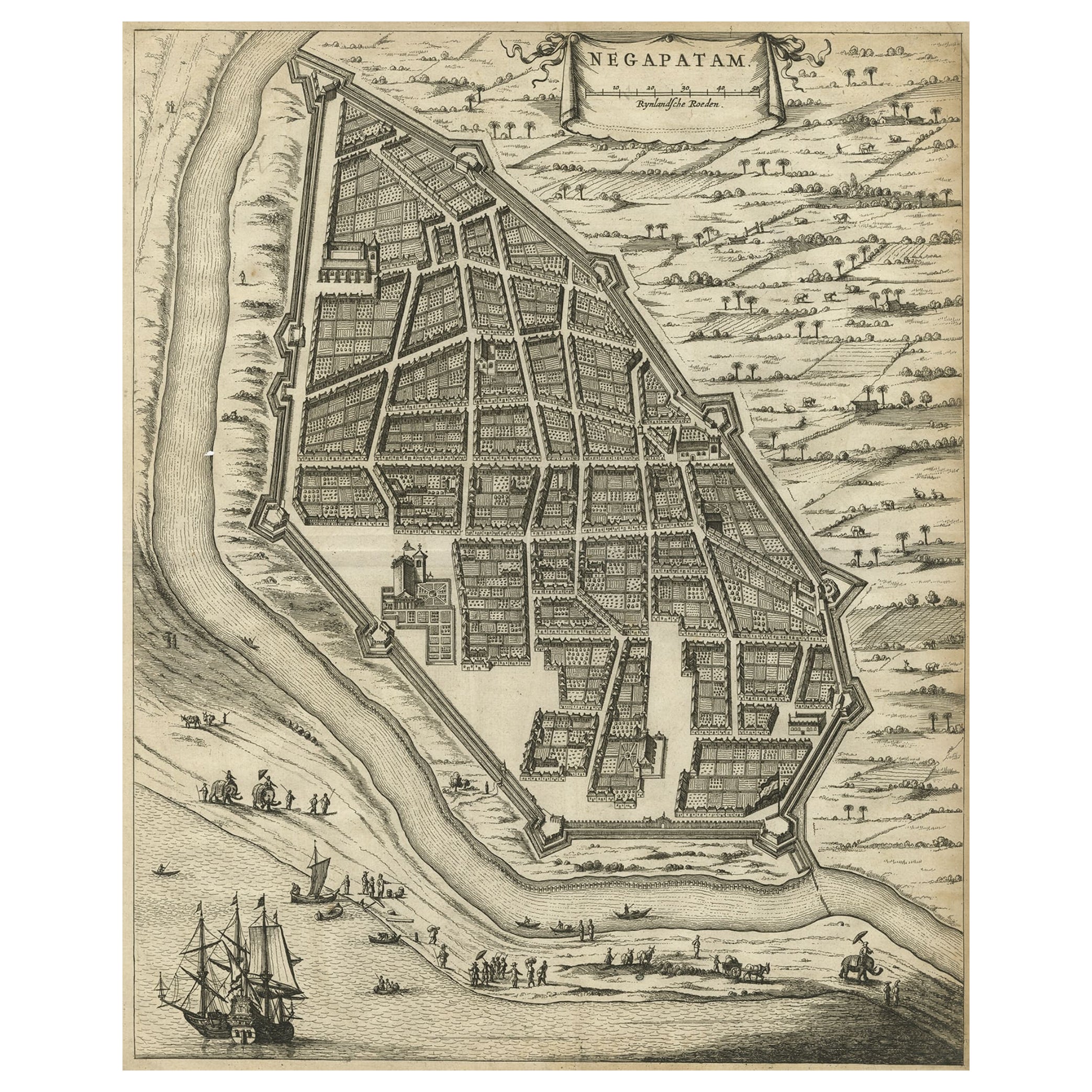
Antique Engraving of a Bird's-Eye Plan of Nagapattinam or Negapatam, India, 1672
Located in Langweer, NL
Antique map titled 'Negapatam.'
Bird's-eye plan of Nagapattinam or Negapatam, India. This map originates from 'Naauwkeurige Beschryvinge van Malabar en Choromandel…en het machtige ...
Category
Antique 1670s Maps
Materials
Paper
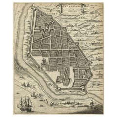
$325 Sale Price
20% Off
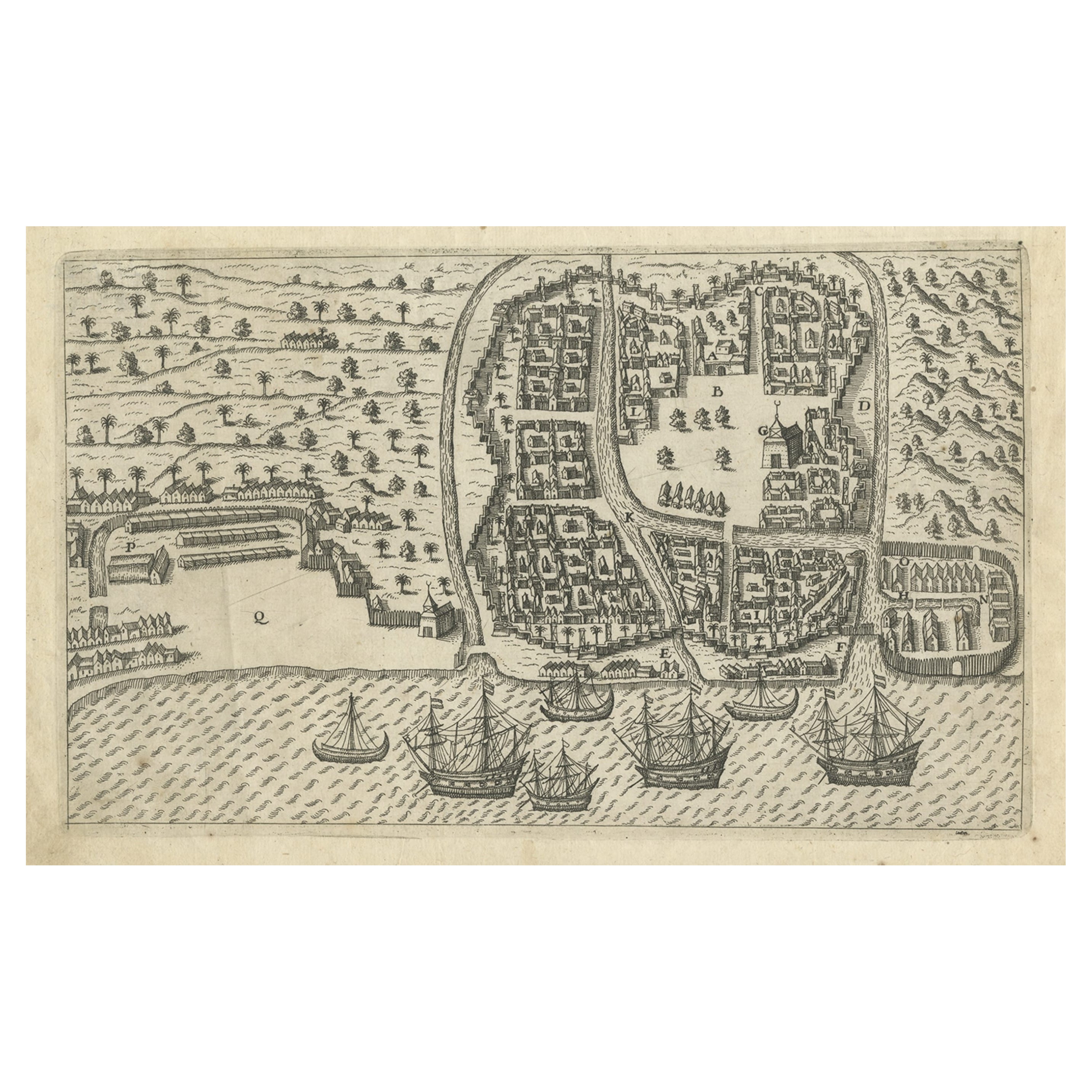
Antique Print of Bantam, Java, Indonesia by De Bry, c.1610
Located in Langweer, NL
Untitled print of Bantam, former city and sultanate of Java, Indonesia. It lay near the site of the present-day city of Banten, on Banten Bay, at the extreme northwest of the island....
Category
Antique 17th Century Prints
Materials
Paper
$364 Sale Price
20% Off
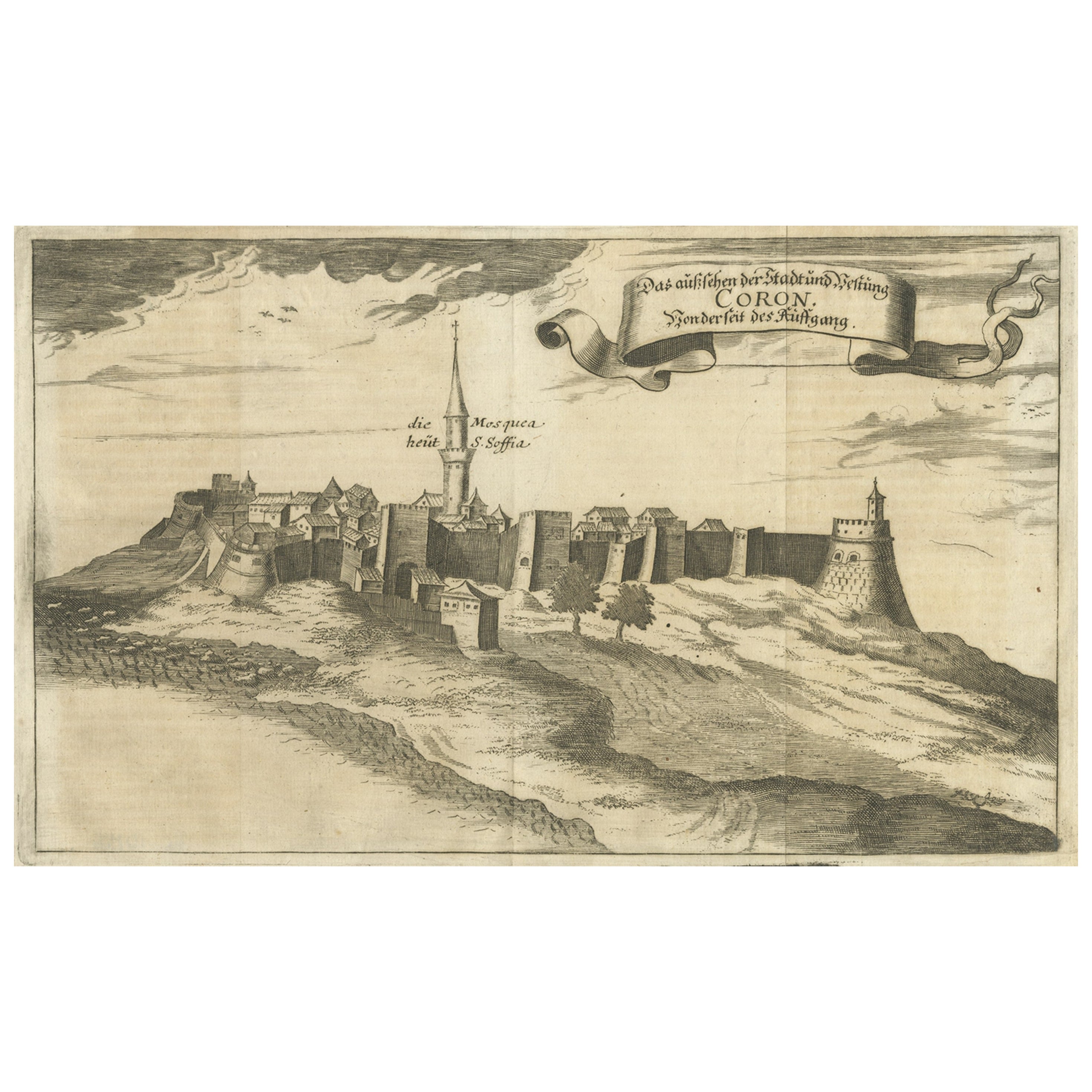
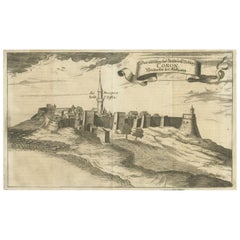
Original Copper Engraving of Koroni 'or Corone', Greece, 1688
Located in Langweer, NL
Antique print titled 'Das Aussehen der Stadt und Vestung Coron von der Seit des Auffgang'.
Copper engraving of Koroni (or Corone), Greece. This print originates from 'Ruhm-belorb...
Category
Antique 1680s Maps
Materials
Paper
$249 Sale Price
20% Off
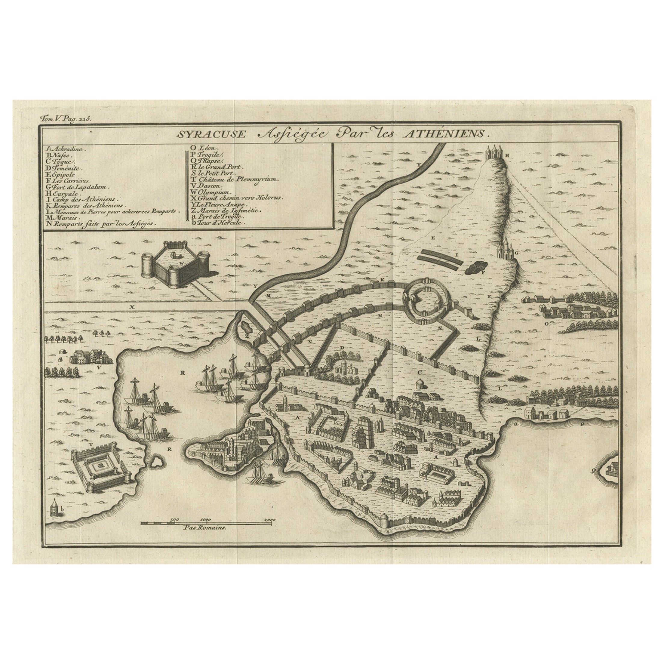
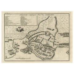
Old Copper Engraving of the Siege of Syracuse, Sicily, Italy, Published, ca.1740
Located in Langweer, NL
Antique print titled 'Syracuse, Assiégée par les Atheniens'.
Old print of the siege of Syracuse, Sicily, Italy. Source unknown, to be determined.
The siege of Syracuse by the...
Category
Antique 1740s Maps
Materials
Paper
$268 Sale Price
20% Off
You May Also Like
Antique Voc Print Holland Malaysia Old Map Melaka History, 1663
Located in Amsterdam, Noord Holland
From my own collection I offer this impressive Antique print of the city of Malakka
A very interesting piece for collectors . It is an museum piece from the Dutch Institute of Orien...
Category
Antique 17th Century European Paintings
Materials
Paper

$293 Sale Price
20% Off
Map of the Netherlands - Etching by G. Braun and F. Hogenberg -Late 16th Century
By Franz Hogenberg
Located in Roma, IT
Map of the Netherlands is an original etching realized by George Braun and Franz Hogenberg, as part of the "Civitates Orbis Terrarum".
The “Civitates Orbis Terrarum” (Atlas of Citi...
Category
16th Century Figurative Prints
Materials
Etching

Map of Embden - Original Etching by G. Braun e F. Hogenberg - Late 16th Century
By Franz Hogenberg
Located in Roma, IT
This map of Embdena is an original etching realized by George Braun and Franz Hogenberg in the Late 16th Century, as part of the famous Series "Civitates Orbis Terrarum" (Atlas of t...
Category
16th Century Figurative Prints
Materials
Etching

1597 German Map of Alexandria by Georg Braun and Frans Hogenberg
By Georg Braun and Frans Hogenberg
Located in Chapel Hill, NC
1597 Map of Alexandria by Georg Braun and Frans Hogenberg, Germany. From "Civitas Orbis Terrarum", part 2, published in Cologne by Bertram Buchholz. Printed in 2 parts. Title: "Alexa...
Category
Antique 16th Century German Renaissance Maps
Materials
Paper

Map of Burdegalen - Original Etching by George Braun - 1575 ca.
Located in Roma, IT
This Burdegalen is an original etching realized in about 1575 by George Braun (1541 – 1622)
The state of preservation of the artwork is good and aged on the edges of the sheet with...
Category
16th Century More Prints
Materials
Etching
17th-18th Century Siege of Graves Mapping Engraving By Willian III
Located in Kingston, NY
RARE French 17th-18th Century Enhanced Siege of Graves Mapping Engraving BY William III, also widely known as William of Orange,
The Siege of Grave in Dutch Brabant started by Monsie...
Category
Antique 17th Century French Prints
Materials
Paper

More Ways To Browse
Rhodes Greece
Antique J Hook
Antique Maple Corner Cabinet
Antique Riding Crops
Antique Wood Horse Antiques
Antique Wood Lathes
Antique Wooden Cars
Apostle Paul
Aqua Coral
Arne Wahl Iversen Teak
Art Deco King Bed Frame
Art Nouveau Comb
Arts And Crafts Bureau
Asian Painted Plate Black
Asian Wooden Bowl
Asprey Leather
Biedermeier Chest High
Birdcage Dining Table