Items Similar to Antique Print of Brittenburg 'Near Katwijk', the Netherlands by Blaeu, '1649'
Want more images or videos?
Request additional images or videos from the seller
1 of 6
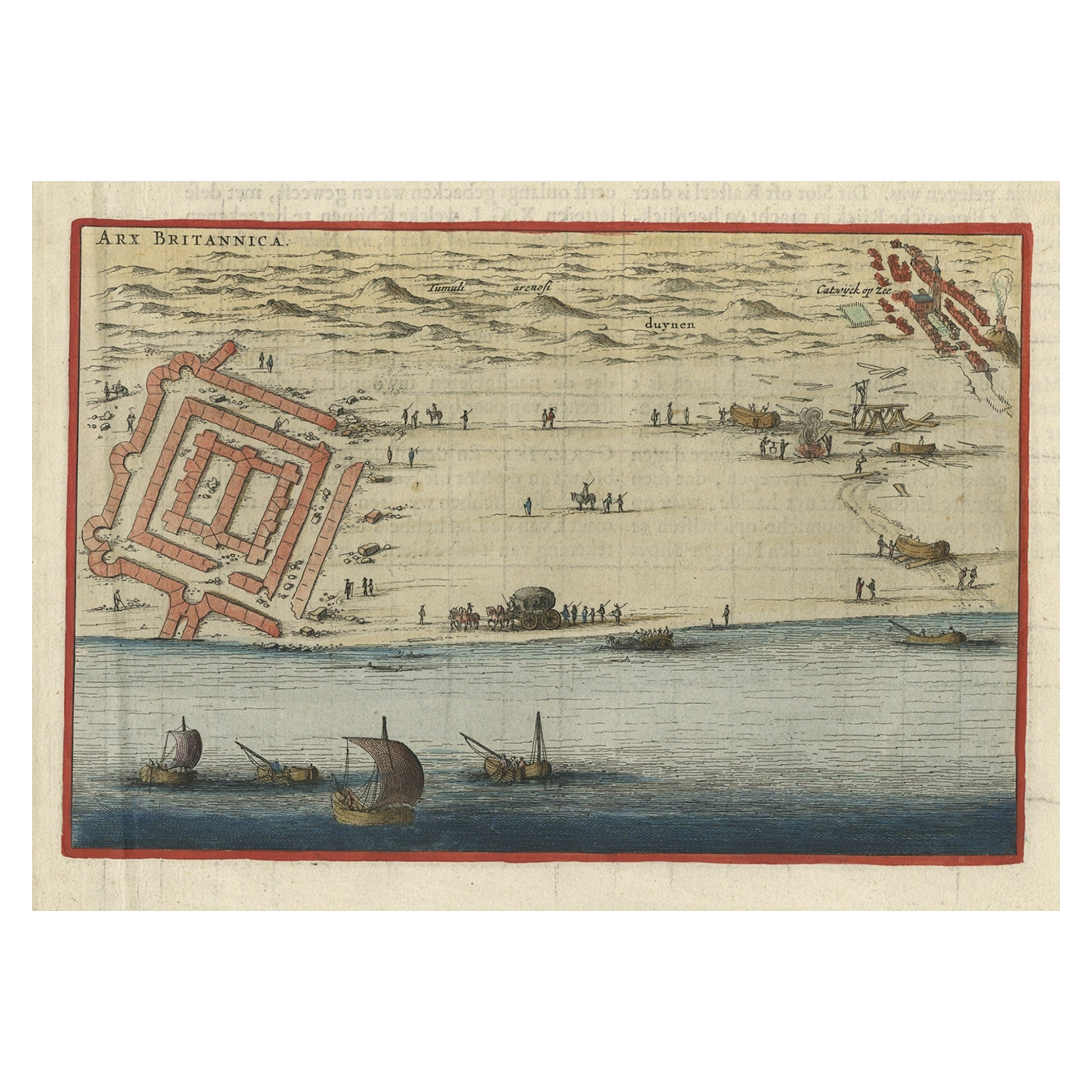
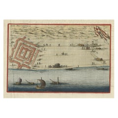
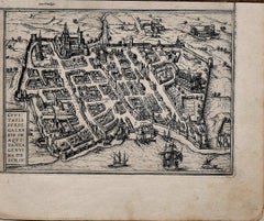
Antique Print of Brittenburg 'Near Katwijk', the Netherlands by Blaeu, '1649'
$210.80
$263.5020% Off
£156.22
£195.2720% Off
€176
€22020% Off
CA$287.79
CA$359.7320% Off
A$320.15
A$400.1920% Off
CHF 167.83
CHF 209.7820% Off
MX$3,912.14
MX$4,890.1820% Off
NOK 2,137.06
NOK 2,671.3220% Off
SEK 2,011.74
SEK 2,514.6820% Off
DKK 1,340.05
DKK 1,675.0620% Off
Shipping
Retrieving quote...The 1stDibs Promise:
Authenticity Guarantee,
Money-Back Guarantee,
24-Hour Cancellation
About the Item
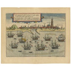
Antique print titled 'Arx Britannica'. View of De Brittenburg, a Roman ruin on the Dutch coast near Katwijk, The Netherlands. Originates from 'Toneel der Steeden' published by Joan Blaeu 1649.
Artists and Engravers: Joan Blaeu (23 September 1596 - 28 May 1673) was a Dutch cartographer. He was born in Alkmaar, the son of cartographer Willem Blaeu. In 1620 he became a doctor of law but he joined the work of his father. In 1635 they published the Atlas Novus (full title: Theatrum orbis terrarum, sive, Atlas novus) in two volumes. Joan and his brother Cornelius took over the studio after their father died in 1638. Joan became the official cartographer of the Dutch East India Company. Around 1649 Joan Blaeu published a collection of Dutch city maps named Tooneel der Steeden (Views of Cities). In 1651 he was voted into the Amsterdam council. In 1654 Joan published the first atlas of Scotland, devised by Timothy Pont. In 1662 he reissued the atlas with 11 volumes, and one for oceans. It was also known as Atlas Maior. A cosmology was planned as their next project, but a fire destroyed the studio completely in 1672. Joan Blaeu died in Amsterdam the following year.
Condition: Good, given age. Dutch text on verso. General age-related toning and/or occasional minor defects from handling. Please study image carefully.
Date: 1649
Overall size: 27 x 19.7 cm.
Image size: 22.7 x 15 cm.
We sell original antique maps to collectors, historians, educators and interior decorators all over the world. Our collection includes a wide range of authentic antique maps from the 16th to the 20th centuries. Buying and collecting antique maps is a tradition that goes back hundreds of years. Antique maps have proved a richly rewarding investment over the past decade, thanks to a growing appreciation of their unique historical appeal. Today the decorative qualities of antique maps are widely recognized by interior designers who appreciate their beauty and design flexibility. Depending on the individual map, presentation, and context, a rare or antique map can be modern, traditional, abstract, figurative, serious or whimsical. We offer a wide range of authentic antique maps for any budget.
- Dimensions:Height: 7.76 in (19.7 cm)Width: 10.63 in (27 cm)Depth: 0 in (0.01 mm)
- Materials and Techniques:
- Period:
- Date of Manufacture:1649
- Condition:Condition: Good, given age. Dutch text on verso. General age-related toning and/or occasional minor defects from handling. Please study image carefully.
- Seller Location:Langweer, NL
- Reference Number:Seller: PC-588911stDibs: LU3054329354532
About the Seller
5.0
Recognized Seller
These prestigious sellers are industry leaders and represent the highest echelon for item quality and design.
Platinum Seller
Premium sellers with a 4.7+ rating and 24-hour response times
Established in 2009
1stDibs seller since 2017
2,502 sales on 1stDibs
Typical response time: <1 hour
- ShippingRetrieving quote...Shipping from: Langweer, Netherlands
- Return Policy
Authenticity Guarantee
In the unlikely event there’s an issue with an item’s authenticity, contact us within 1 year for a full refund. DetailsMoney-Back Guarantee
If your item is not as described, is damaged in transit, or does not arrive, contact us within 7 days for a full refund. Details24-Hour Cancellation
You have a 24-hour grace period in which to reconsider your purchase, with no questions asked.Vetted Professional Sellers
Our world-class sellers must adhere to strict standards for service and quality, maintaining the integrity of our listings.Price-Match Guarantee
If you find that a seller listed the same item for a lower price elsewhere, we’ll match it.Trusted Global Delivery
Our best-in-class carrier network provides specialized shipping options worldwide, including custom delivery.More From This Seller
View AllAntique Print of Brittenburg 'Near Katwijk' in the Netherlands by Blaeu, 1649
Located in Langweer, NL
Antique print titled 'Arx Britannica'. View of De Brittenburg, a Roman ruin on the Dutch coast near Katwijk, The Netherlands. Originates from 'Toneel der Steeden' published by Joan B...
Category
Antique 17th Century Prints
Materials
Paper
$229 Sale Price
20% Off
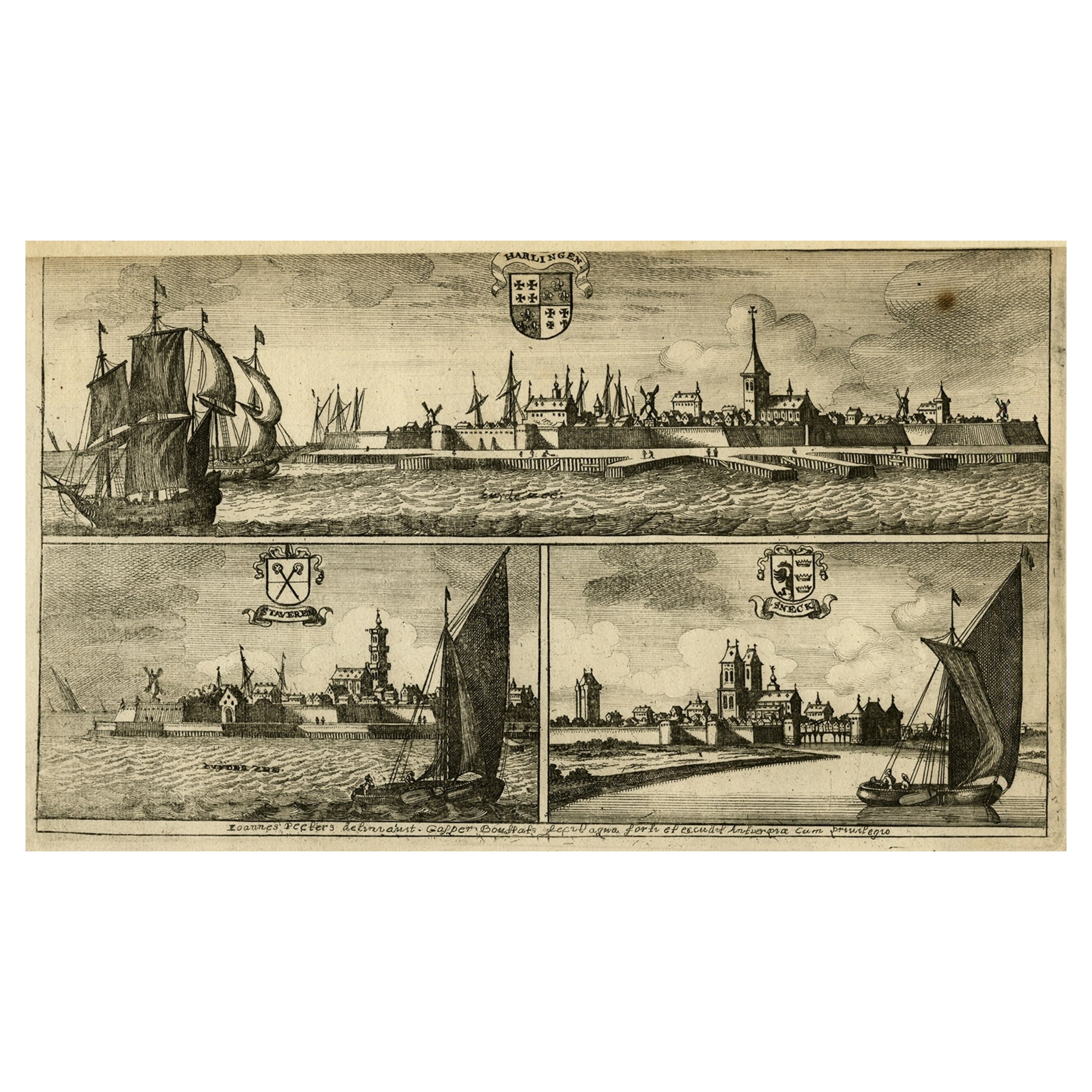
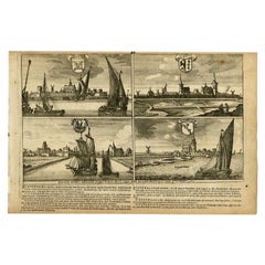
Antique Print of Harlingen, Stavoren and Sneek in Friesland, 1680
Located in Langweer, NL
Antique print titled 'Harlingen, Staveren, Sneck'. Views of the cities of Harlingen, Stavoren and Sneek, Friesland, the Netherlands. This print originates from 'Thooneel der Steden e...
Category
Antique 17th Century Prints
Materials
Paper
$220 Sale Price
20% Off
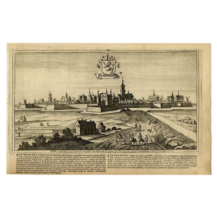
Antique Print of the City of Leeuwarden by Bouttats, 1680
Located in Langweer, NL
Antique print titled 'Leeuwaerd'. Old bird's eye view of the city of Leeuwarden, Friesland. This print originates from 'Thooneel der Steden ende Sterckten van 't Vereenight Nederland...
Category
Antique 17th Century Prints
Materials
Paper

$153 Sale Price
20% Off
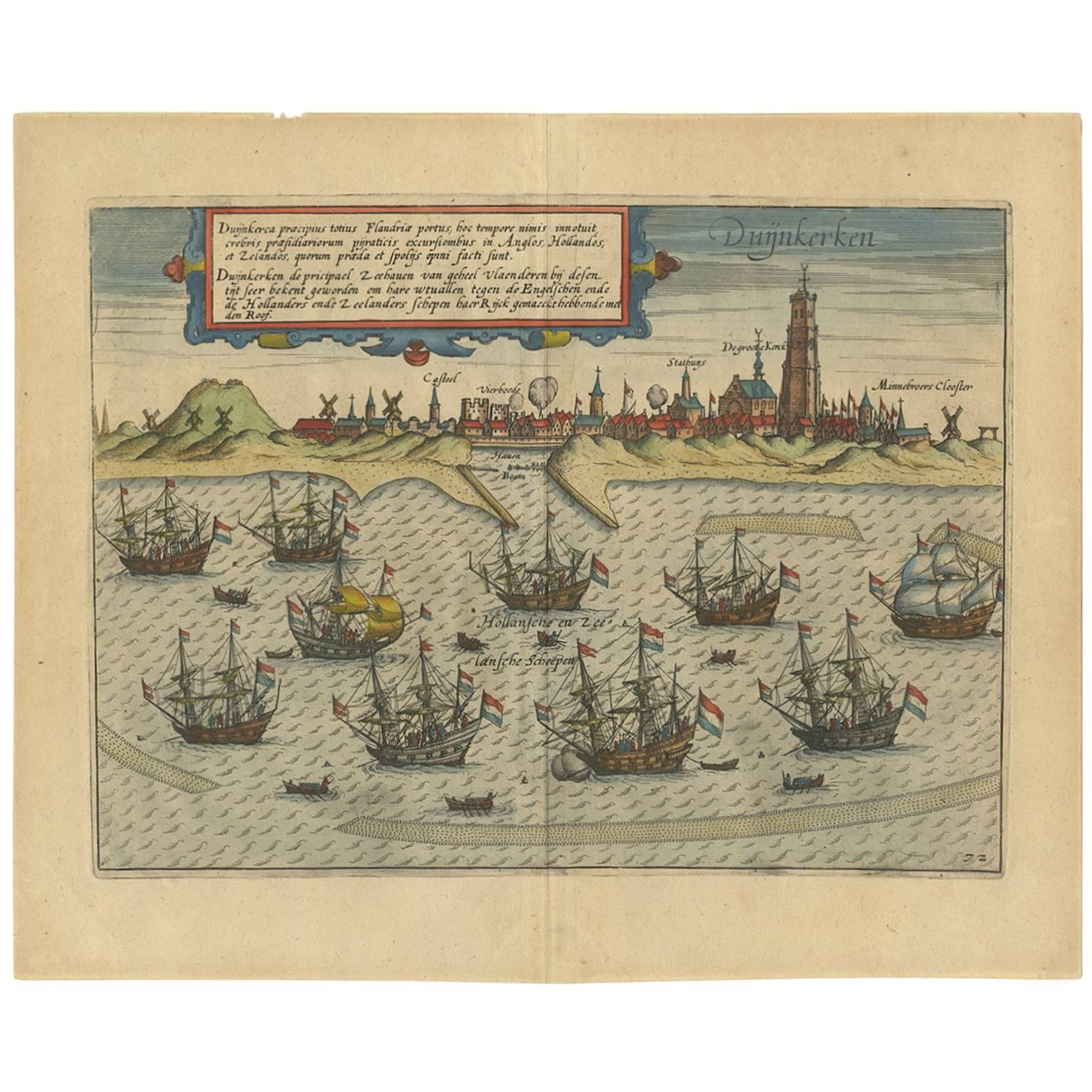
Antique Print of the Town of Duinkerken ‘France’ by L. Guicciardini, 1613
Located in Langweer, NL
Beautiful bird's eye-view plan of the town of Duinkerken. From Ludovico Guicciardini.'s description of the Netherlands 'Beschrijvinghe van alle de Nederlanden anderssins ghenoemt Ned...
Category
Antique Early 17th Century Prints
Materials
Paper
$541 Sale Price
20% Off
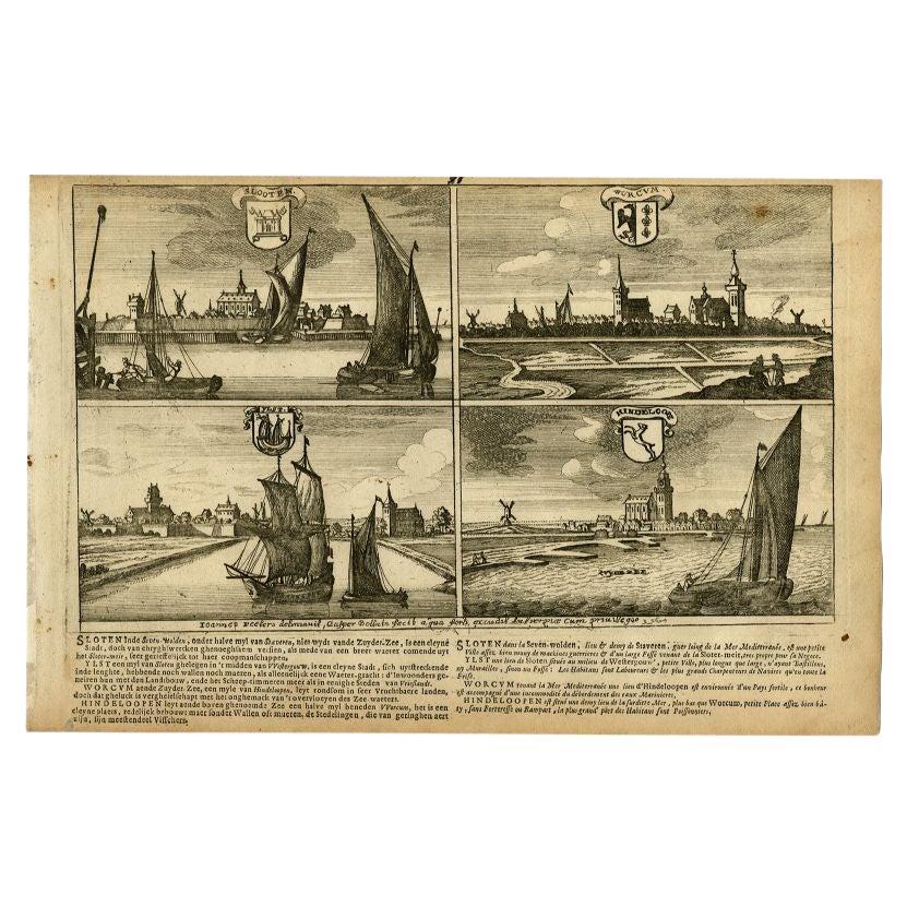
Antique Print of Sloten, IJlst, Workum and Hindeloopen in The Netherlands, 1680
Located in Langweer, NL
"Antique print titled 'Slooten, Worcum, Ylst and Hindeloope'. Bird's eye views of Sloten, IJlst, Workum and Hindeloopen, Friesland, the Netherlands. This original antique print origi...
Category
Antique 17th Century Prints
Materials
Paper
$210 Sale Price
20% Off
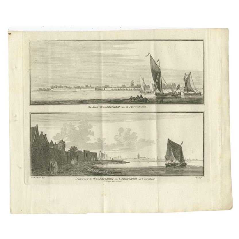
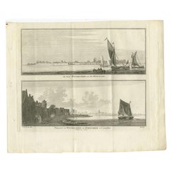
Antique Print of Woudrichem, a Fortified Town on the Merwede in Brabant, Holland
Located in Langweer, NL
Antique print titled 'De Stad Woudrichem van de Merwe te zien - Waterpoort te Woudrichem en Gorinchem in 't Verschiet'. Copper engraving with two views of Woudrichem, the Netherlands...
Category
Antique 18th Century Prints
Materials
Paper
$153 Sale Price
20% Off
You May Also Like
Antique Voc Print Holland Malaysia Old Map Melaka History, 1663
Located in Amsterdam, Noord Holland
From my own collection I offer this impressive Antique print of the city of Malakka
A very interesting piece for collectors . It is an museum piece from the Dutch Institute of Orien...
Category
Antique 17th Century European Paintings
Materials
Paper

$293 Sale Price
20% Off
Lithograph View on Nieuw Amsterdam J . Vingboons 1660s
Located in Den Haag, NL
Afther a gouache by J Vingboons 1660s Beautiful Lithograph from 1910/20
Nieuw Amsterdam ofte nue nieuw Lorx opt Teyland Man .
Very nice fresh colors . Comes with a old label on the...
Category
Antique 1650s Dutch American Colonial Prints
Materials
Paper
Map of Dordrecht - Etching by G. Braun/F. Hogenberg - Late 16th Century
Located in Roma, IT
Map od Dordrecht is an artwork realized by Braun and Hogemberg in the late 16th century.
Hand watercolored etching.
40x54 cm.
Good conditions.
Braun Hoghemberg (1541-1622) was a ...
Category
16th Century Old Masters Figurative Prints
Materials
Etching

Map of the Netherlands - Etching by G. Braun and F. Hogenberg -Late 16th Century
By Franz Hogenberg
Located in Roma, IT
Map of the Netherlands is an original etching realized by George Braun and Franz Hogenberg, as part of the "Civitates Orbis Terrarum".
The “Civitates Orbis Terrarum” (Atlas of Citi...
Category
16th Century Figurative Prints
Materials
Etching

17th Century Topographical Engraving Nantes & St. Malo, France, by Iohan Peeters
Located in New York, NY
The ancient city of Saint Malo in North Western France has long been associated with adventure on the high seas, piracy and exploration. It was the birthplace of several important in...
Category
Antique 17th Century Dutch Maps
Materials
Paper

Map of Burdegalen - Original Etching by George Braun - 1575 ca.
Located in Roma, IT
This Burdegalen is an original etching realized in about 1575 by George Braun (1541 – 1622)
The state of preservation of the artwork is good and aged on the edges of the sheet with...
Category
16th Century More Prints
Materials
Etching
More Ways To Browse
Blaeu Wall Map
American Iron Bed
Antique Cabin Decor
Antique Calendar Plates
Antique Double Bed Frame
Antique Enamel Kitchen Cabinets
Antique Hotel Key
Antique Ironstone Bowls
Antique Japanese Cast Iron
Antique Keyhole Cover
Antique Last Supper
Antique Mahogany Serving Tray
Antique Painted Writing Bureau
Antique Queen Bed Headboard
Antique Silver Chocolate Pot
Antique Soda
Antique Staffordshire Dogs
Antique Swedish Bureau