Items Similar to Antique Print of Brittenburg 'Near Katwijk' in the Netherlands by Blaeu, 1649
Want more images or videos?
Request additional images or videos from the seller
1 of 6
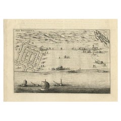
Antique Print of Brittenburg 'Near Katwijk' in the Netherlands by Blaeu, 1649
About the Item
Antique print titled 'Arx Britannica'. View of De Brittenburg, a Roman ruin on the Dutch coast near Katwijk, The Netherlands. Originates from 'Toneel der Steeden' published by Joan Blaeu 1649.
Artists and Engravers: Joan Blaeu (23 September 1596 - 28 May 1673) was a Dutch cartographer. He was born in Alkmaar, the son of cartographer Willem Blaeu. In 1620 he became a doctor of law but he joined the work of his father. In 1635 they published the Atlas Novus (full title: Theatrum orbis terrarum, sive, Atlas novus) in two volumes. Joan and his brother Cornelius took over the studio after their father died in 1638. Joan became the official cartographer of the Dutch East India Company. Around 1649 Joan Blaeu published a collection of Dutch city maps named Tooneel der Steeden (Views of Cities). In 1651 he was voted into the Amsterdam council. In 1654 Joan published the first atlas of Scotland, devised by Timothy Pont. In 1662 he reissued the atlas with 11 volumes, and one for oceans. It was also known as Atlas Maior. A cosmology was planned as their next project, but a fire destroyed the studio completely in 1672. Joan Blaeu died in Amsterdam the following year.
Condition: Very good, Dutch text on verso. Please study image carefully.
Date: 1649
Overall size: 30.5 x 21 cm.
Image size: 23 x 15.5 cm.
We sell original antique maps to collectors, historians, educators and interior decorators all over the world. Our collection includes a wide range of authentic antique maps from the 16th to the 20th centuries. Buying and collecting antique maps is a tradition that goes back hundreds of years. Antique maps have proved a richly rewarding investment over the past decade, thanks to a growing appreciation of their unique historical appeal. Today the decorative qualities of antique maps are widely recognized by interior designers who appreciate their beauty and design flexibility. Depending on the individual map, presentation, and context, a rare or antique map can be modern, traditional, abstract, figurative, serious or whimsical. We offer a wide range of authentic antique maps for any budget.
- Dimensions:Height: 8.27 in (21 cm)Width: 12.01 in (30.5 cm)Depth: 0 in (0.01 mm)
- Materials and Techniques:
- Period:
- Date of Manufacture:1649
- Condition:Condition: Very good, Dutch text on verso. Please study image carefully.
- Seller Location:Langweer, NL
- Reference Number:
About the Seller
5.0
Platinum Seller
These expertly vetted sellers are 1stDibs' most experienced sellers and are rated highest by our customers.
Established in 2009
1stDibs seller since 2017
1,948 sales on 1stDibs
Typical response time: <1 hour
- ShippingRetrieving quote...Ships From: Langweer, Netherlands
- Return PolicyA return for this item may be initiated within 14 days of delivery.
More From This SellerView All
- Antique Print of Brittenburg 'Near Katwijk', the Netherlands by Blaeu, '1649'Located in Langweer, NLAntique print titled 'Arx Britannica'. View of De Brittenburg, a Roman ruin on the Dutch coast near Katwijk, The Netherlands. Originates from 'Toneel der Steeden' published by Joan B...Category
Antique 17th Century Prints
MaterialsPaper
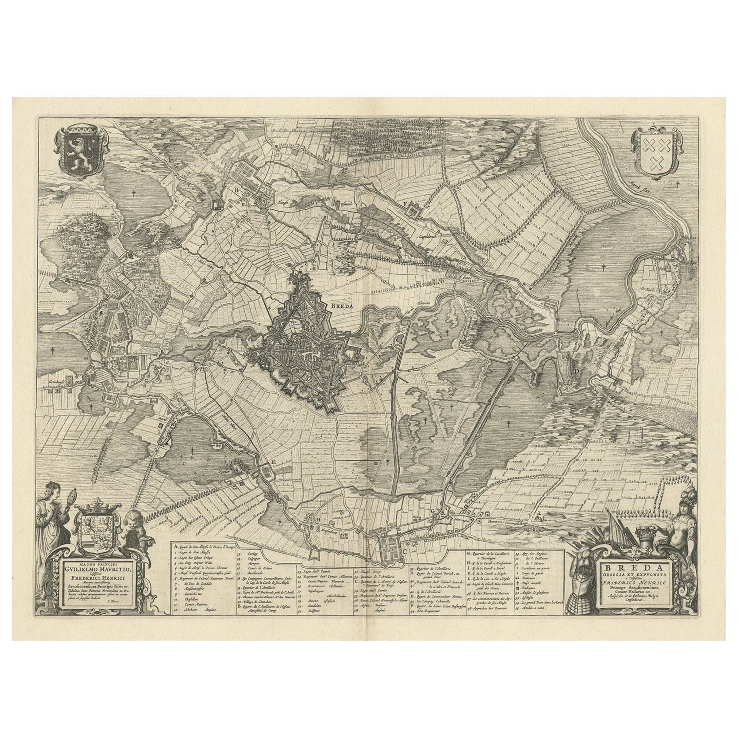
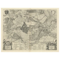
- Antique Map of the Siege of Breda, City in the Netherlands by Blaeu, 1649Located in Langweer, NLAntique map titled 'Breda obsessa et expugnata a Celsissimo Frederico Henrico'. Old map of the city of Breda, the Netherlands. It shows the Siege of Breda in 1637. Originates fro...Category
Antique 17th Century Maps
MaterialsPaper
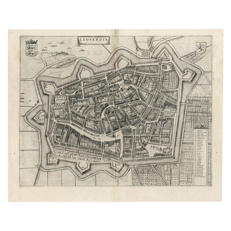
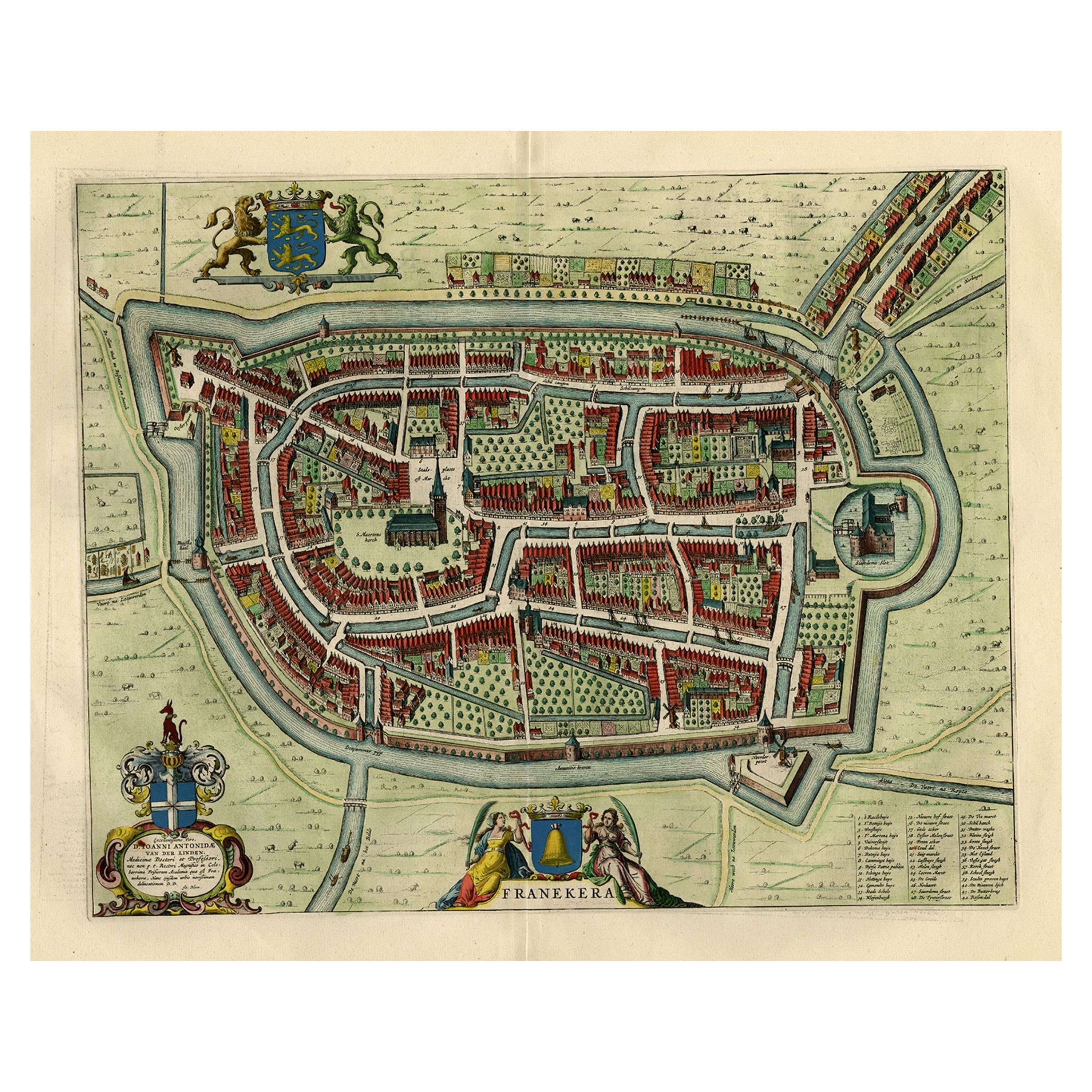
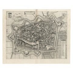
- Antique Map of Leeuwarden, Capital of Friesland, the Netherlands, by Blaeu, 1649Located in Langweer, NLAntique map titled 'Leoverdia.' Bird's-eye view plan of Leeuwarden, Friesland, the Netherlands. With key to locations and coats of arms. Text in Dutch on verso. This plan origina...Category
Antique 17th Century Maps
MaterialsPaper
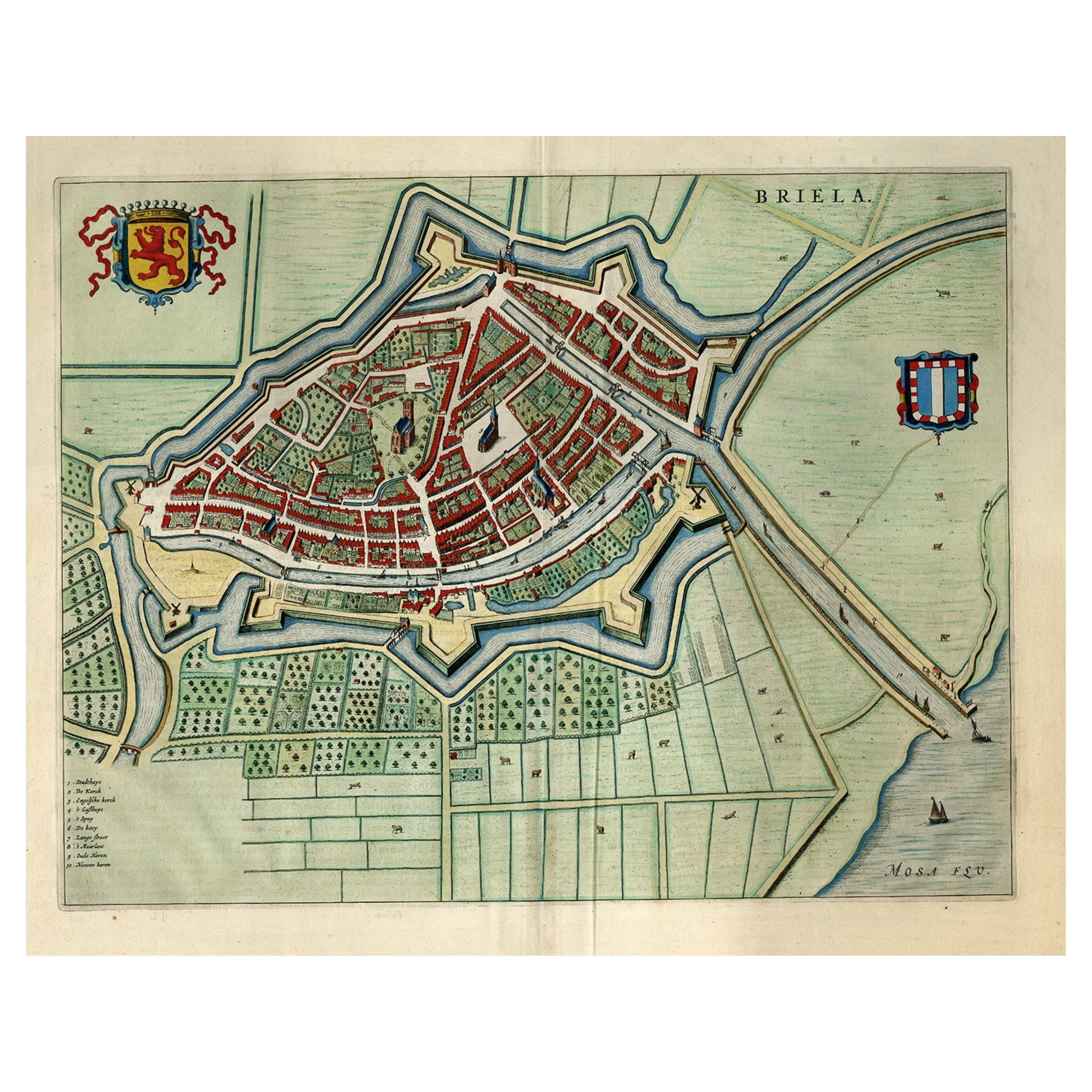
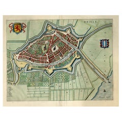
- Great Antique Bird's-Eye View Plan of Brielle by Blaeu in The Netherlands, 1649Located in Langweer, NLAntique print, titled: 'Briela.' Bird's-eye view plan of Brielle in The Netherlands. With key to locations and coats of arms. Text in Dutch on verso. This plan originates from the famous city Atlas: 'Toneel der Steeden' published by Joan Blaeu...Category
Antique 1640s Maps
MaterialsPaper
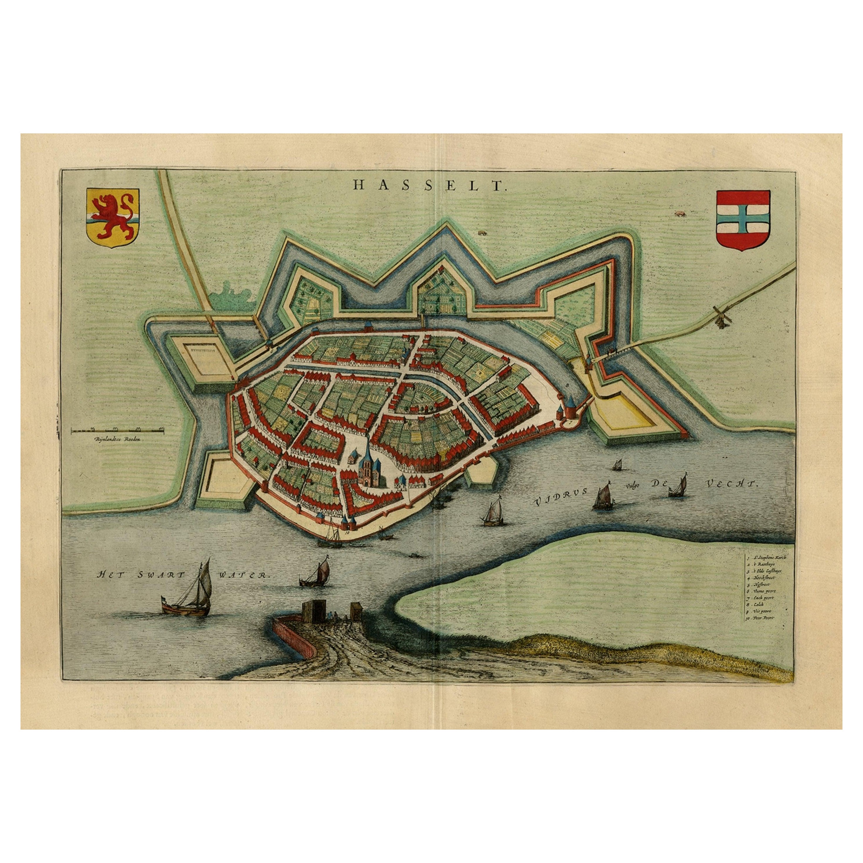
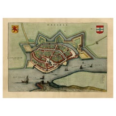
- Stunning Bird's-Eye View Plan of Hasselt by Blaeu in The Netherlands, 1649Located in Langweer, NLAntique print, titled: 'Hasselt.' Bird's-eye view plan of Hasselt in The Netherlands. With key to locations and coats of arms. Text in Dutch on verso. This plan originates from the famous city Atlas: 'Toneel der Steeden' published by Joan Blaeu...Category
Antique 1640s Maps
MaterialsPaper
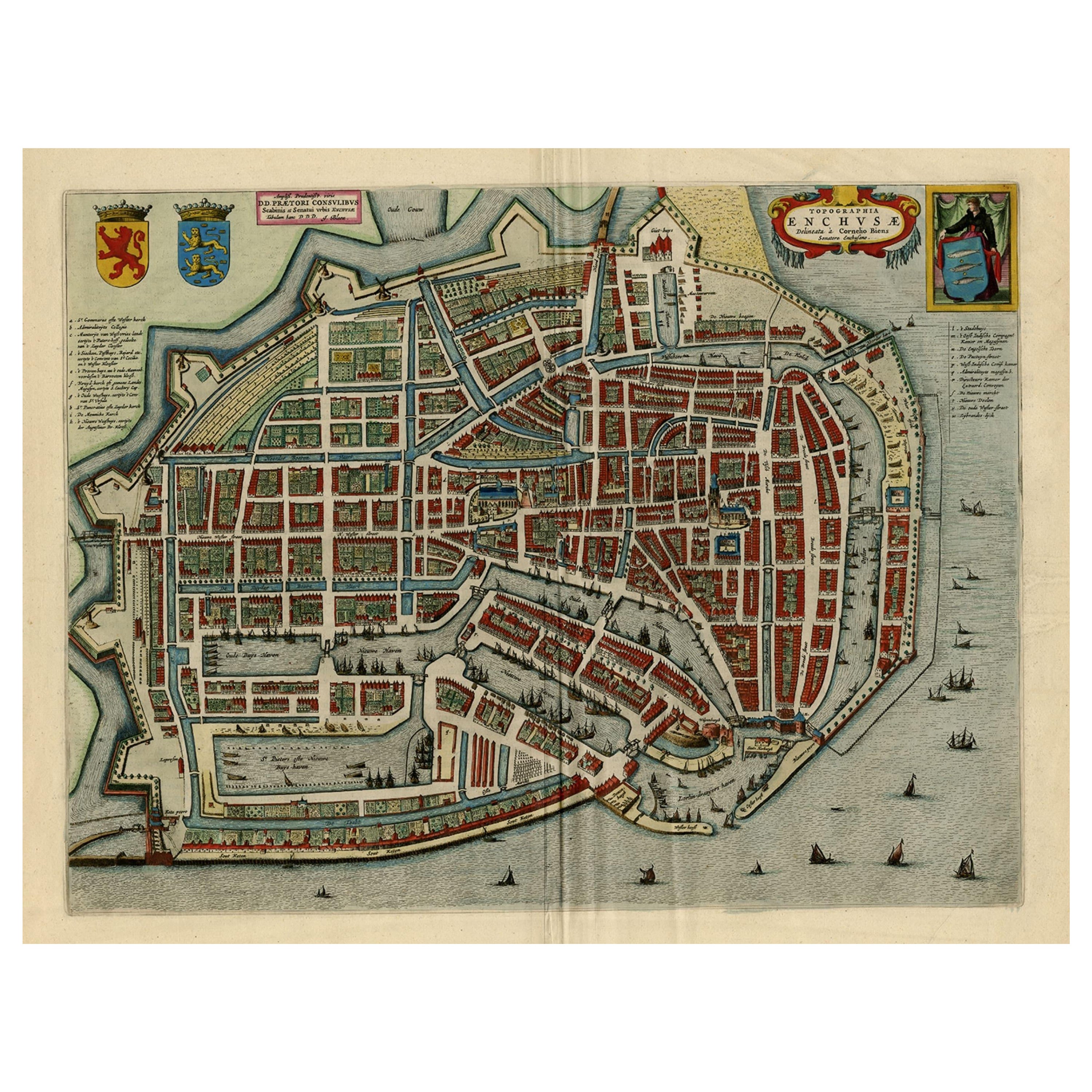
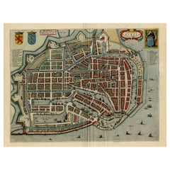
- Beautiful Bird's-Eye View Plan of Enkhuizen in The Netherlands by Blaeu, 1649Located in Langweer, NLAntique print, titled: 'Topograhpiae Enchusae.' Bird's-eye view plan of Enkhuizen in The Netherlands, with key to locations and coats of arms. Text in Dutch on verso. This plan o...Category
Antique 1640s Maps
MaterialsPaper
You May Also Like
- Original Antique Map of The Netherlands, Engraved by Barlow, Dated 1807Located in St Annes, LancashireGreat map of Netherlands Copper-plate engraving by Barlow Published by Brightly & Kinnersly, Bungay, Suffolk. Dated 1807 Unframed.Category
Antique Early 1800s English Maps
MaterialsPaper
- Original Antique Map of The Netherlands, Sherwood, Neely & Jones, Dated 1809Located in St Annes, LancashireGreat map of The Netherlands Copper-plate engraving by Cooper Published by Sherwood, Neely & Jones. Dated 1809 Unframed.Category
Antique Early 1800s English Maps
MaterialsPaper
- Civil War Panorama of the Seat of War by John Bachmann, Antique Print circa 1864Located in Colorado Springs, COPanorama of the seat of war. Bird's-eye View of Virginia, Maryland, Delaware and the District of Columbia. This third state of this fascinating bird's eye view of the northernmost p...Category
Antique 1860s American Maps
MaterialsPaper
- Old Nautical Print Depicting the Bombardment of Cadiz by the French Navy 1823Located in Milan, ITPrint by engraving on copper plate of the first half of the 19th century, depicting the bombardment of Cadiz by the French Navy, 23 September 1823. The print is signed peint par Crep...Category
Antique 1830s French Nautical Objects
MaterialsPaper
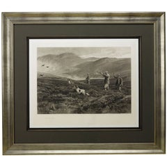
- “On the Moors” or "Dogging" Signed by Heywood Hardy, Antique Print, 1894By Heywood HardyLocated in Colorado Springs, COPresented is an 1894 signed first edition goupil-gravure print by Heywood Hardy (1842-1933). The engraving was printed in Paris and published by Boussod Valadon & Co. Publishers, the successors to Goupil & Co. Designed as a companion to After the Drive, Hardy’s On the Moors (Dogging) depicts three hunters and their two dogs hunting ducks. The youngest of the three men is shooting his gun as the dogs excitedly wait to chase after the bird. This print is one of only 75 artist’s proofs and has been signed by the artist in pencil at the lower left corner of the print’s margin. Hunting has a long history in England and is considered a very traditional activity even today. One of the most popular forms of hunting is called “wildfowling” and targets wild geese and ducks. Often conducted on coastal marshes, wildfowling is typically a solitary or small group sport unlike the grand group fox and pheasant hunts...Category
Antique 1890s French Prints
MaterialsPaper
- Antique Lithographic Print of the Diamond Rock Battle Early 1900s, Oakwood FrameLocated in Milan, ITLithographic print of the diamond rock battle, the main port of the island of Martinique, taken from the book Historical Gallery of Versailles 112. Chacoane is the engraver. Original...Category
Early 20th Century French Nautical Objects
MaterialsPaper


Recently Viewed
View AllMore Ways To Browse
Roman Furniture Company
Fire Coast
17th Century Scotland
Blaeu World Map
Cornelius Company
Joan Blaeu
Blaeu India
French Display Cabinet Carved
Large Walnut Chest Of Drawers
Antique Ivory Pieces
Painted Cabinet Mahogany
Mid Century Commode Black
Swedish Gustavian Commode
1960 Wood Small Cabinet
Art Deco Display Cabinets
Art Deco Display Cabinet
China Cabinet Display Cabinet
Chinese Display Cabinet