Items Similar to Antique Map of the Siege of Breda, City in the Netherlands by Blaeu, 1649
Want more images or videos?
Request additional images or videos from the seller
1 of 5
Antique Map of the Siege of Breda, City in the Netherlands by Blaeu, 1649
About the Item
Antique map titled 'Breda obsessa et expugnata a Celsissimo Frederico Henrico'.
Old map of the city of Breda, the Netherlands. It shows the Siege of Breda in 1637. Originates from 'Novum Ac Magnum Theatrum Urbium Belgicae Liberae Ac Foederatae'.
Artists and Engravers: Joan Blaeu (23 September 1596 - 28 May 1673) was a Dutch cartographer. He was born in Alkmaar, the son of cartographer Willem Blaeu. In 1620 he became a doctor of law but he joined the work of his father. In 1635 they published the Atlas Novus (full title: Theatrum orbis terrarum, sive, Atlas novus) in two volumes. Joan and his brother Cornelius took over the studio after their father died in 1638. Joan became the official cartographer of the Dutch East India Company. Around 1649 Joan Blaeu published a collection of Dutch city maps named Tooneel der Steeden (Views of Cities). In 1651 he was voted into the Amsterdam council. In 1654 Joan published the first atlas of Scotland, devised by Timothy Pont. In 1662 he reissued the atlas with 11 volumes, and one for oceans. It was also known as Atlas Maior. A cosmology was planned as their next project, but a fire destroyed the studio completely in 1672. Joan Blaeu died in Amsterdam the following year.
Condition: Great condition, Latin text on verso. Please study image carefully.
Date: 1649
Overall size: 61 x 53 cm.
Image size: 54 x 41 cm.
We sell original antique maps to collectors, historians, educators and interior decorators all over the world. Our collection includes a wide range of authentic antique maps from the 16th to the 20th centuries. Buying and collecting antique maps is a tradition that goes back hundreds of years. Antique maps have proved a richly rewarding investment over the past decade, thanks to a growing appreciation of their unique historical appeal. Today the decorative qualities of antique maps are widely recognized by interior designers who appreciate their beauty and design flexibility. Depending on the individual map, presentation, and context, a rare or antique map can be modern, traditional, abstract, figurative, serious or whimsical. We offer a wide range of authentic antique maps for any budget.
- Dimensions:Height: 20.87 in (53 cm)Width: 24.02 in (61 cm)Depth: 0 in (0.01 mm)
- Materials and Techniques:
- Period:
- Date of Manufacture:1649
- Condition:Condition: Great condition, Latin text on verso. Please study image carefully.
- Seller Location:Langweer, NL
- Reference Number:
About the Seller
5.0
Platinum Seller
These expertly vetted sellers are 1stDibs' most experienced sellers and are rated highest by our customers.
Established in 2009
1stDibs seller since 2017
1,929 sales on 1stDibs
Typical response time: <1 hour
- ShippingRetrieving quote...Ships From: Langweer, Netherlands
- Return PolicyA return for this item may be initiated within 14 days of delivery.
More From This SellerView All
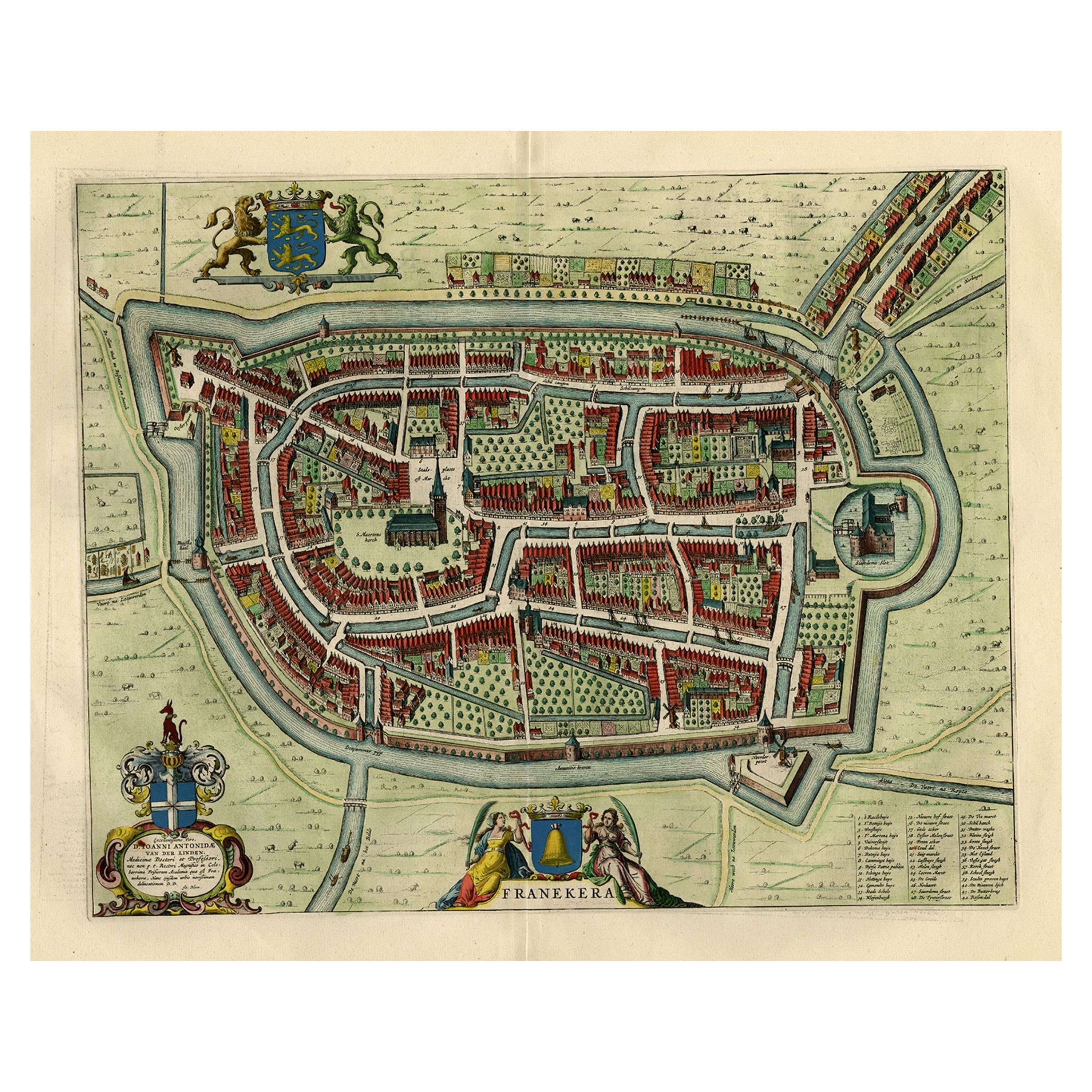
- Old Map by Blaeu of the City of Franeker, Friesland, The Netherlands, 1649Located in Langweer, NLAntique map titled 'Franekera'. Old map of the city of Franeker, Friesland. Also shows two cartouches, coats of arms and legend. This map originates from a Latin edition of the t...Category
Antique 1640s Maps
MaterialsPaper
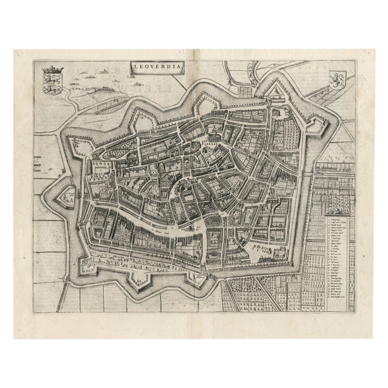
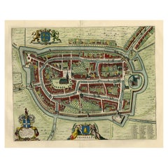
- Antique Map of Leeuwarden, Capital of Friesland, the Netherlands, by Blaeu, 1649Located in Langweer, NLAntique map titled 'Leoverdia.' Bird's-eye view plan of Leeuwarden, Friesland, the Netherlands. With key to locations and coats of arms. Text in Dutch on verso. This plan origina...Category
Antique 17th Century Maps
MaterialsPaper
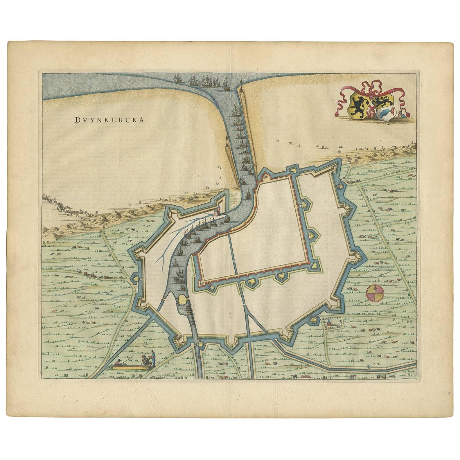
- Antique Map of Dunkirk 'France' by J. Blaeu, 1649Located in Langweer, NLAntique map titled 'Duynkercka'. Published by J. Blaeu, 1649. Dutch text on verso.Category
Antique Mid-17th Century Maps
MaterialsPaper
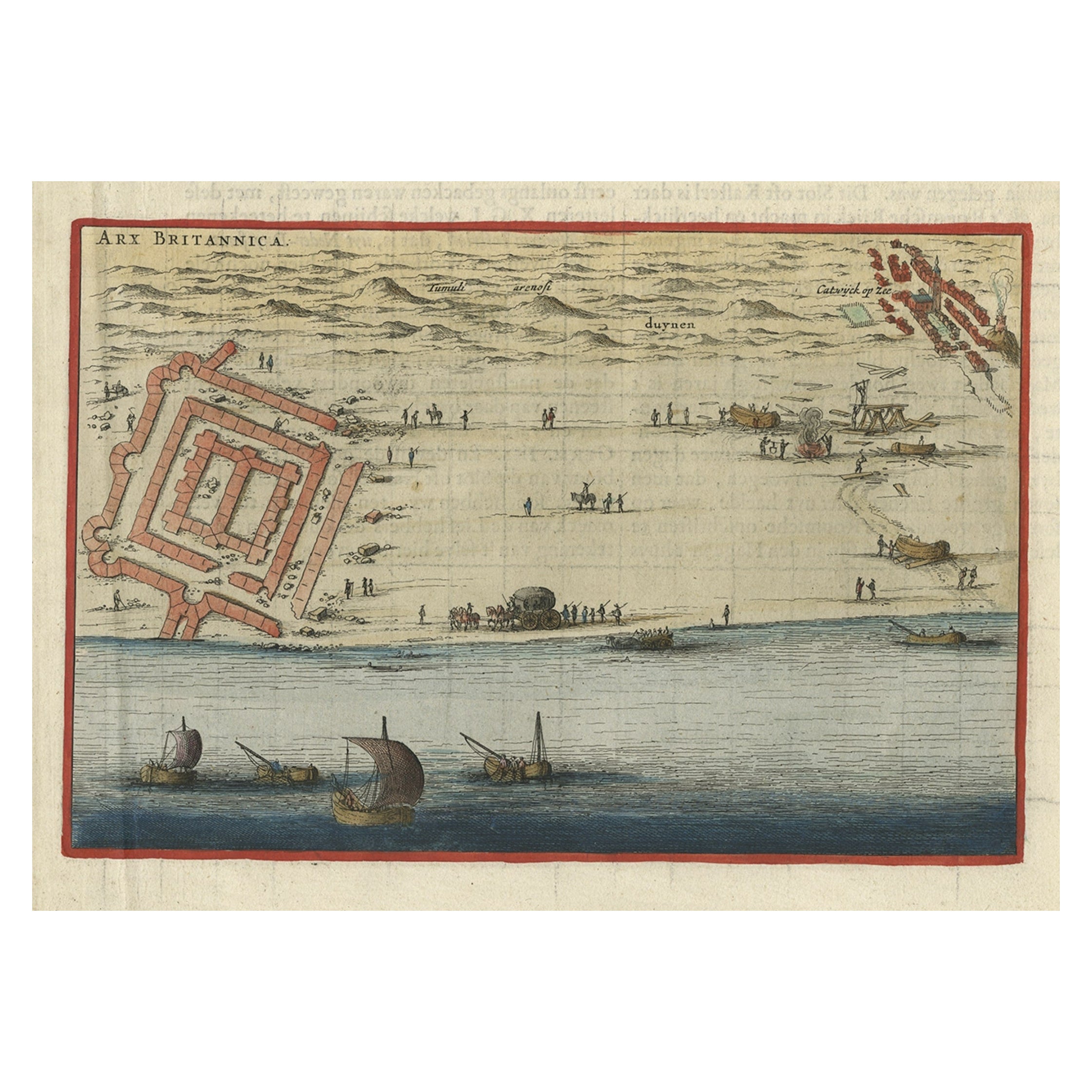
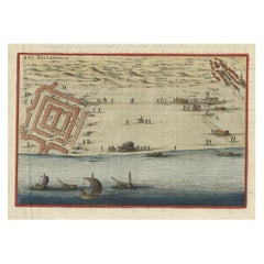
- Antique Print of Brittenburg 'Near Katwijk' in the Netherlands by Blaeu, 1649Located in Langweer, NLAntique print titled 'Arx Britannica'. View of De Brittenburg, a Roman ruin on the Dutch coast near Katwijk, The Netherlands. Originates from 'Toneel der Steeden' published by Joan B...Category
Antique 17th Century Prints
MaterialsPaper
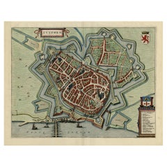
- Original Map with Bird's-Eye View of Zutphen in the Netherlands by Blaeu, 1649Located in Langweer, NLAntique print, titled: 'Zutphen.' - Bird's-eye view plan of Zutphen in The Netherlands, with key to locations and coats of arms. Text in Dutch on verso. This plan originates from the famous city Atlas: 'Toneel der Steeden' published by Joan Blaeu...Category
Antique 1640s Maps
MaterialsPaper
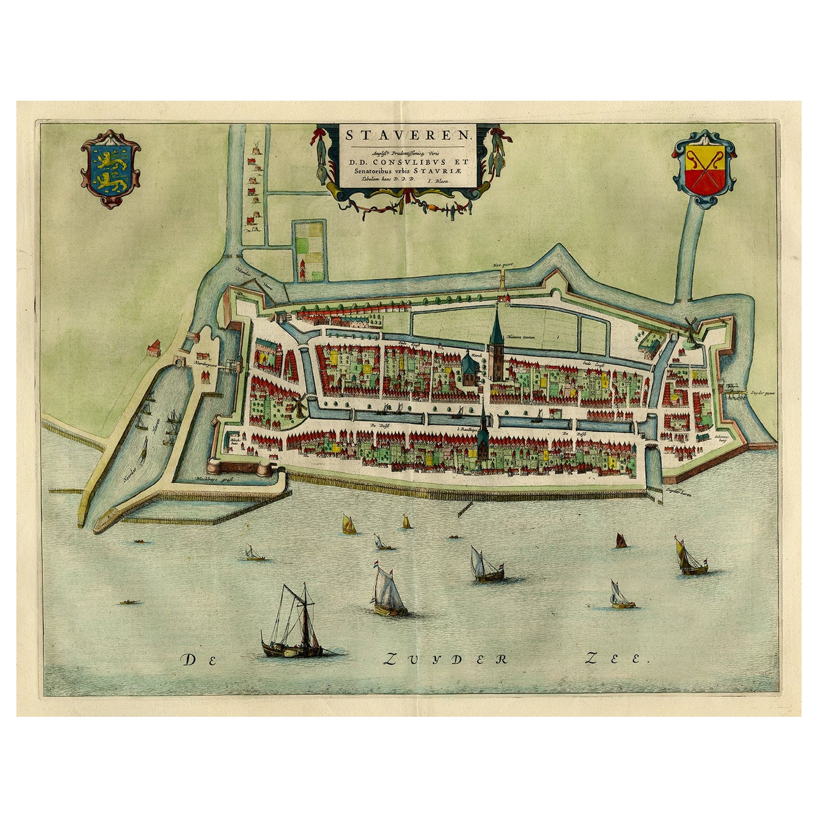
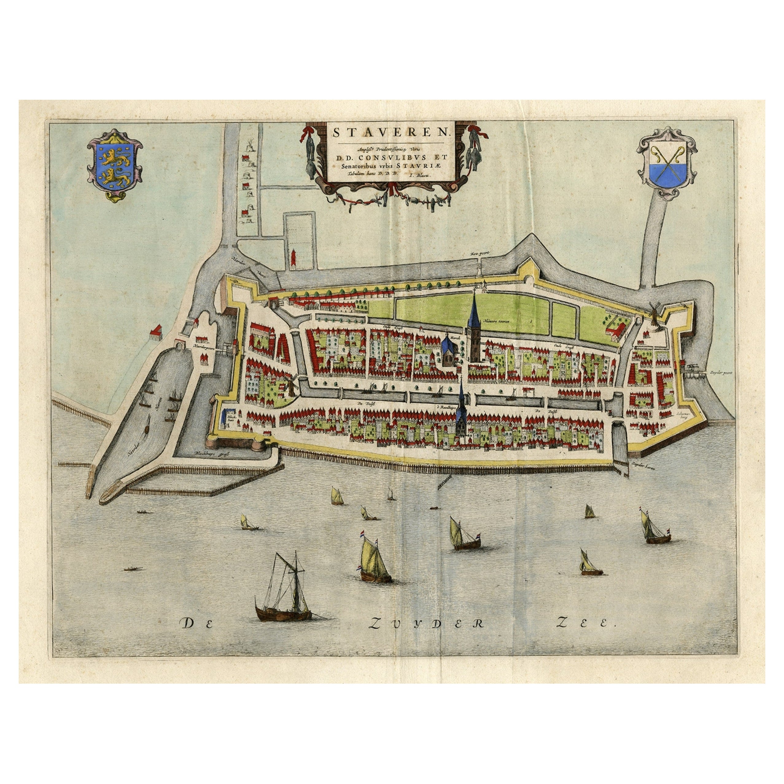
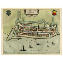
- Original Antique Map of the City of Stavoren, Friesland, The Netherlands, 1649Located in Langweer, NLAntique map titled 'Staveren'. Original antique map of the city of Stavoren, Friesland, The Netherlands. This map originates from 'Toonneel der Steden van de Vereenighde Nederlanden'...Category
Antique 1640s Maps
MaterialsPaper

You May Also Like
- Original Antique Map of The Netherlands, Engraved by Barlow, Dated 1807Located in St Annes, LancashireGreat map of Netherlands Copper-plate engraving by Barlow Published by Brightly & Kinnersly, Bungay, Suffolk. Dated 1807 Unframed.Category
Antique Early 1800s English Maps
MaterialsPaper
- Original Antique Map of The Netherlands, Sherwood, Neely & Jones, Dated 1809Located in St Annes, LancashireGreat map of The Netherlands Copper-plate engraving by Cooper Published by Sherwood, Neely & Jones. Dated 1809 Unframed.Category
Antique Early 1800s English Maps
MaterialsPaper
- Original Antique Map / City Plan of Brussels by Tallis, circa 1850Located in St Annes, LancashireGreat map of Brussels. Steel engraving. Published by London Printing & Publishing Co. (Formerly Tallis), C.1850 Free shipping.Category
Antique 1850s English Maps
MaterialsPaper
- Original Antique Map of The World by Thomas Clerk, 1817Located in St Annes, LancashireGreat map of The Eastern and Western Hemispheres On 2 sheets Copper-plate engraving Drawn and engraved by Thomas Clerk, Edinburgh. Published by Mackenzie And Dent, 1817 ...Category
Antique 1810s English Maps
MaterialsPaper
- Map of the Republic of GenoaLocated in New York, NYFramed antique hand-coloured map of the Republic of Genoa including the duchies of Mantua, Modena, and Parma. Europe, late 18th century. Dimension: 25...Category
Antique Late 18th Century European Maps
- Antique Map of Italy by Andriveau-Goujon, 1843By Andriveau-GoujonLocated in New York, NYAntique Map of Italy by Andriveau-Goujon, 1843. Map of Italy in two parts by Andriveau-Goujon for the Library of Prince Carini at Palazzo Carini i...Category
Antique 1840s French Maps
MaterialsLinen, Paper


