Items Similar to Antique Print of Bunce Island an Island in the Sierra Leone River, 1748


Want more images or videos?
Request additional images or videos from the seller
1 of 6
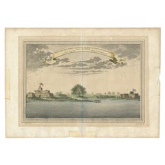
Antique Print of Bunce Island an Island in the Sierra Leone River, 1748
$210.87
$263.5920% Off
£156.95
£196.1920% Off
€176
€22020% Off
CA$288.84
CA$361.0520% Off
A$321.26
A$401.5720% Off
CHF 167.75
CHF 209.6920% Off
MX$3,909.36
MX$4,886.7020% Off
NOK 2,142.43
NOK 2,678.0420% Off
SEK 2,009.22
SEK 2,511.5320% Off
DKK 1,339.83
DKK 1,674.7820% Off
Shipping
Retrieving quote...The 1stDibs Promise:
Authenticity Guarantee,
Money-Back Guarantee,
24-Hour Cancellation
About the Item
Antique print titled 'Vue de l'Ile et du Fort de Bense, tirée de Smith - Gezigt van 't Eiland en 't Fort Bense, uit Smith'. This print depicts Bunce Island, an island in the Sierra Leone River. Bunce Island was the departure point for thousands of slaves for the North American colonies of South Carolina and Georgia. This print originates from 'Historische beschryving der Reizen (..)', published by P. de Hondt, 1748.
Artists and Engravers: Jakob van der Schley (Amsterdam 1715-1779) was a Dutch draughtsman and engraver. He studied under Bernard Picart and became heavily influenced by his style.
Condition: Very good, general age-related toning. Please study image carefully.
Date: 1748
Overall size: 15 x 20 cm.
Image size: 20 x 25 cm.
We sell original antique maps to collectors, historians, educators and interior decorators all over the world. Our collection includes a wide range of authentic antique maps from the 16th to the 20th centuries. Buying and collecting antique maps is a tradition that goes back hundreds of years. Antique maps have proved a richly rewarding investment over the past decade, thanks to a growing appreciation of their unique historical appeal. Today the decorative qualities of antique maps are widely recognized by interior designers who appreciate their beauty and design flexibility. Depending on the individual map, presentation, and context, a rare or antique map can be modern, traditional, abstract, figurative, serious or whimsical. We offer a wide range of authentic antique maps for any budget.
- Creator:Jakob van der Schley (Artist)
- Dimensions:Height: 7.88 in (20 cm)Width: 5.91 in (15 cm)Depth: 0 in (0.01 mm)
- Materials and Techniques:
- Period:
- Date of Manufacture:1748
- Condition:Condition: Very good, general age-related toning. Please study image carefully.
- Seller Location:Langweer, NL
- Reference Number:Seller: BG-034921stDibs: LU3054329355492
About the Seller
5.0
Recognized Seller
These prestigious sellers are industry leaders and represent the highest echelon for item quality and design.
Platinum Seller
Premium sellers with a 4.7+ rating and 24-hour response times
Established in 2009
1stDibs seller since 2017
2,502 sales on 1stDibs
Typical response time: <1 hour
- ShippingRetrieving quote...Shipping from: Langweer, Netherlands
- Return Policy
Authenticity Guarantee
In the unlikely event there’s an issue with an item’s authenticity, contact us within 1 year for a full refund. DetailsMoney-Back Guarantee
If your item is not as described, is damaged in transit, or does not arrive, contact us within 7 days for a full refund. Details24-Hour Cancellation
You have a 24-hour grace period in which to reconsider your purchase, with no questions asked.Vetted Professional Sellers
Our world-class sellers must adhere to strict standards for service and quality, maintaining the integrity of our listings.Price-Match Guarantee
If you find that a seller listed the same item for a lower price elsewhere, we’ll match it.Trusted Global Delivery
Our best-in-class carrier network provides specialized shipping options worldwide, including custom delivery.More From This Seller
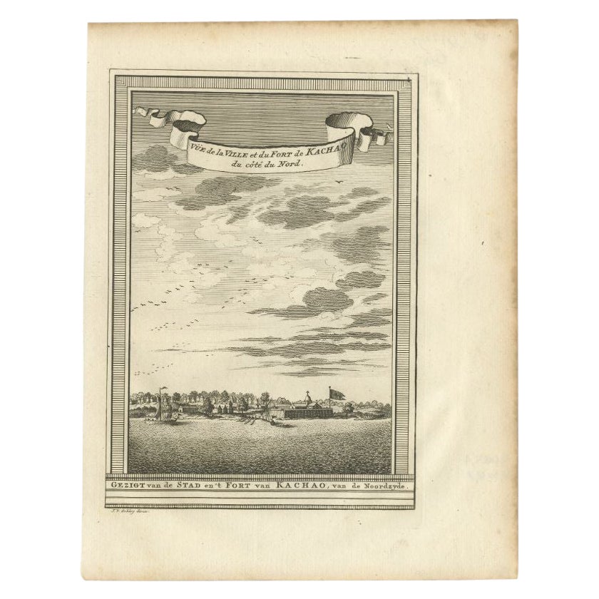
View AllAntique Print of the City and Fortress of Kachao in Guinea Bissau, Africa, 1747
By Jakob van der Schley
Located in Langweer, NL
Antique print titled 'Gezigt van de Stad en 't Fort van Kachao'. View of the city and Fortress of Kachao, Guinea Bissau, Africa. Engraved by J. van Schley for a Dutch edition of 'l'H...
Category
Antique 18th Century Prints
Materials
Paper
$220 Sale Price
20% Off
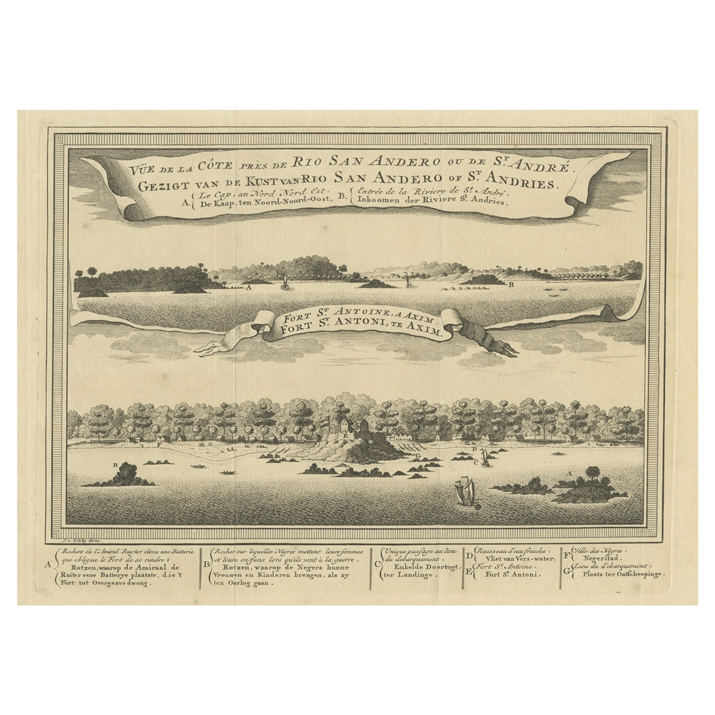
Antique Print of a Fort on the Ivory Coast and Axim, Africa, 1748
By Jakob van der Schley
Located in Langweer, NL
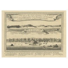
Antique print titled 'Vue de la Cote pres de Rio San Andero - Gezigt van de Kust van Rio San Andero' and 'Fort St. Antoine a Axim - Fort St. Antoni, te Axim'. View of the Ivory coast...
Category
Antique 18th Century Prints
Materials
Paper
$277 Sale Price
20% Off
Antique Print of the English Fort at Dixcove in Ghana, 1748
Located in Langweer, NL
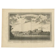
Antique print titled 'Vue sud du Fort de Dickscove - Zuid-gezigt van 't Engelsse Fort te Dixkove'. View of the English fort at Dixcove, Ghana. This print originates from 'Historische...
Category
Antique 18th Century Prints
Materials
Paper
$153 Sale Price
20% Off
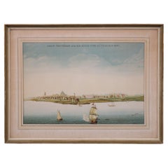
Antique Print of the Bay of Sierra Leone by J. Van Der Schley, 1758
Located in Langweer, NL
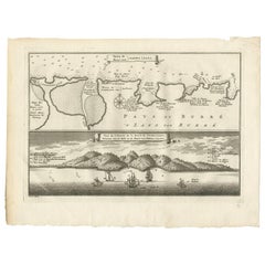
Beautiful map and bird's-eye view of the Bay of Sierra Leone. While these maps by Van Schley after Bellin were initially made for 'Histoire Generale des Voyages' (Paris, 1746-1759), ...
Category
Antique Mid-18th Century Prints
Materials
Paper
$153 Sale Price
20% Off
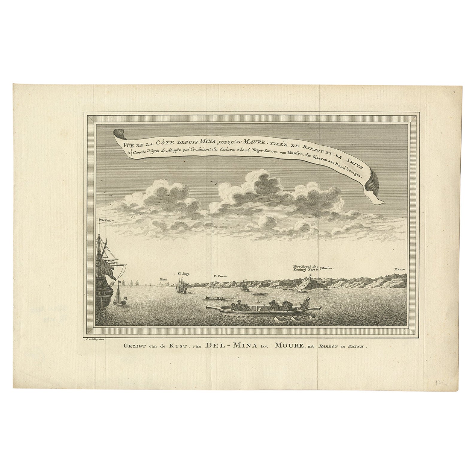
Antique Print of the Coast from Elmina to Moree, West-Africa, 1748
Located in Langweer, NL
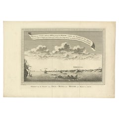
Antique print titled 'Vue de la Côte depuis Mina jusquáu Maure - Gezigt van de Kust, van Del-Mina tot Moure'. View of the coast from Elmina to Moree. This print originates from 'Hist...
Category
Antique 18th Century Prints
Materials
Paper
$210 Sale Price
20% Off
Antique Print of Fortresses at Commendo in Africa, 1746
Located in Langweer, NL
Antique print titled 'Vüe Sud des Forts Anglois et Hollandois de Commendo., tirée de Smith. 1. Fort Anglois. 2. Fort de Uredenbourgh'. Copper engraving of the Dutch and English fortr...
Category
Antique 18th Century Prints
Materials
Paper
$115 Sale Price
20% Off
You May Also Like
West Coast of Africa, Guinea & Sierra Leone: An 18th Century Map by Bellin
By Jacques-Nicolas Bellin
Located in Alamo, CA
Jacques Bellin's copper-plate map entitled "Partie de la Coste de Guinee Dupuis la Riviere de Sierra Leona Jusquau Cap das Palmas", depicting the coast of Guinea and Sierra Leone in ...
Category
Antique Mid-18th Century French Maps
Materials
Paper

Views of Senegal - Original Lithograph - 19th century
Located in Roma, IT
Views of Senegal is an original lithograph artwork realized by an Anonymous engraver of the 19th century.
Printed in the series of "France Pittoresque".
Titled "France Pittoresqu...
Category
19th Century Modern Figurative Prints
Materials
Lithograph
Lithograph View on Nieuw Amsterdam J . Vingboons 1660s
Located in Den Haag, NL
Afther a gouache by J Vingboons 1660s Beautiful Lithograph from 1910/20
Nieuw Amsterdam ofte nue nieuw Lorx opt Teyland Man .
Very nice fresh colors . Comes with a old label on the...
Category
Antique 1650s Dutch American Colonial Prints
Materials
Paper
West Africa Entitled "Guinea Propria": An 18th Century Hand Colored Homann Map
By Johann Baptist Homann
Located in Alamo, CA
This is a scarce richly hand colored copper plate engraved map of Africa entitled "Guinea Propria, nec non Nigritiae vel Terrae Nigrorum Maxima Pars" by Johann Baptist Homann (1664-1...
Category
Antique Mid-18th Century German Maps
Materials
Paper

Antique Voc Print Holland Malaysia Old Map Melaka History, 1663
Located in Amsterdam, Noord Holland
From my own collection I offer this impressive Antique print of the city of Malakka
A very interesting piece for collectors . It is an museum piece from the Dutch Institute of Orien...
Category
Antique 17th Century European Paintings
Materials
Paper

$293 Sale Price
20% Off
West Africa: 18th Century Hand-colored Homann Map Entitled "Guinea Propria"
By Johann Baptist Homann
Located in Alamo, CA
This is a scarce richly hand colored copper plate engraved map of Africa entitled "Guinea Propria, nec non Nigritiae vel Terrae Nigrorum Maxima Pars" by Johann Baptist Homann (1664-1...
Category
1740s Other Art Style Prints and Multiples
Materials
Engraving

More Ways To Browse
American Iron Bed
Antique Cabin Decor
Antique Calendar Plates
Antique Double Bed Frame
Antique Enamel Kitchen Cabinets
Antique Hotel Key
Antique Ironstone Bowls
Antique Japanese Cast Iron
Antique Keyhole Cover
Antique Last Supper
Antique Mahogany Serving Tray
Antique Painted Writing Bureau
Antique Queen Bed Headboard
Antique Silver Chocolate Pot
Antique Soda
Antique Staffordshire Dogs
Antique Swedish Bureau
Antique Wood Bull