Items Similar to Antique Print of a Fort on the Gold Coast of Africa by Dapper, c.1670


Want more images or videos?
Request additional images or videos from the seller
1 of 6
Antique Print of a Fort on the Gold Coast of Africa by Dapper, c.1670
$407.37
£303.20
€340
CA$557.99
A$620.61
CHF 324.06
MX$7,552.17
NOK 4,138.79
SEK 3,881.45
DKK 2,588.30
Shipping
Retrieving quote...The 1stDibs Promise:
Authenticity Guarantee,
Money-Back Guarantee,
24-Hour Cancellation
About the Item
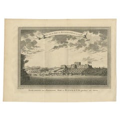
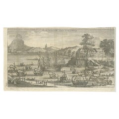
`Antique print titled 'Kasteel van Cormantin/The castle Cormantine'. Fine engraving depicting one of the forts on the Gold Coast of Africa. Cormantine Castle first was a British fort, later the Dutch captured it and named it 'Fort Amsterdam'. Originates from 'Naukeurige beschrijvinge der Afrikaensche eylanden'.
Artists and Engravers: Olfert Dapper (c. 1635 - 1689) was a Dutch physician and writer. He wrote books about history and geography, although he never travelled outside Holland.
Condition: Very good, repair on folding line. Few marginal tears, please study image carefully.
Date: c.1670
Overall size: 42 x 34.5 cm.
Image size: 34 x 24 cm.
We sell original antique maps to collectors, historians, educators and interior decorators all over the world. Our collection includes a wide range of authentic antique maps from the 16th to the 20th centuries. Buying and collecting antique maps is a tradition that goes back hundreds of years. Antique maps have proved a richly rewarding investment over the past decade, thanks to a growing appreciation of their unique historical appeal. Today the decorative qualities of antique maps are widely recognized by interior designers who appreciate their beauty and design flexibility. Depending on the individual map, presentation, and context, a rare or antique map can be modern, traditional, abstract, figurative, serious or whimsical. We offer a wide range of authentic antique maps for any budget.
- Dimensions:Height: 13.59 in (34.5 cm)Width: 16.54 in (42 cm)Depth: 0 in (0.01 mm)
- Materials and Techniques:
- Period:
- Date of Manufacture:circa 1670
- Condition:Repaired: repair on folding line. Condition: Very good, repair on folding line. Few marginal tears, please study image carefully.
- Seller Location:Langweer, NL
- Reference Number:Seller: BG-023181stDibs: LU3054329296332
About the Seller
5.0
Recognized Seller
These prestigious sellers are industry leaders and represent the highest echelon for item quality and design.
Platinum Seller
Premium sellers with a 4.7+ rating and 24-hour response times
Established in 2009
1stDibs seller since 2017
2,508 sales on 1stDibs
Typical response time: <1 hour
- ShippingRetrieving quote...Shipping from: Langweer, Netherlands
- Return Policy
Authenticity Guarantee
In the unlikely event there’s an issue with an item’s authenticity, contact us within 1 year for a full refund. DetailsMoney-Back Guarantee
If your item is not as described, is damaged in transit, or does not arrive, contact us within 7 days for a full refund. Details24-Hour Cancellation
You have a 24-hour grace period in which to reconsider your purchase, with no questions asked.Vetted Professional Sellers
Our world-class sellers must adhere to strict standards for service and quality, maintaining the integrity of our listings.Price-Match Guarantee
If you find that a seller listed the same item for a lower price elsewhere, we’ll match it.Trusted Global Delivery
Our best-in-class carrier network provides specialized shipping options worldwide, including custom delivery.More From This Seller
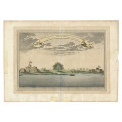
View AllAntique Print of the English Fort at Dixcove in Ghana, 1748
Located in Langweer, NL
Antique print titled 'Vue sud du Fort de Dickscove - Zuid-gezigt van 't Engelsse Fort te Dixkove'. View of the English fort at Dixcove, Ghana. This print originates from 'Historische...
Category
Antique 18th Century Prints
Materials
Paper
$153 Sale Price
20% Off
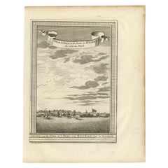
Antique Print of Fortresses at Commendo in Africa, 1746
Located in Langweer, NL
Antique print titled 'Vüe Sud des Forts Anglois et Hollandois de Commendo., tirée de Smith. 1. Fort Anglois. 2. Fort de Uredenbourgh'. Copper engraving of the Dutch and English fortr...
Category
Antique 18th Century Prints
Materials
Paper
$115 Sale Price
20% Off
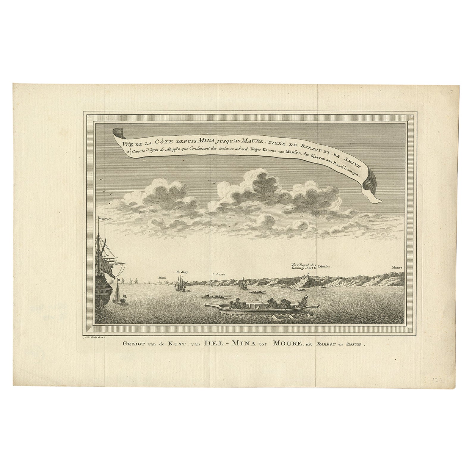
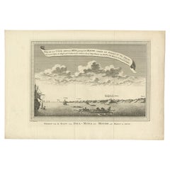
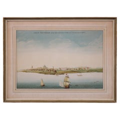
Antique Print of the Coast from Elmina to Moree, West-Africa, 1748
Located in Langweer, NL
Antique print titled 'Vue de la Côte depuis Mina jusquáu Maure - Gezigt van de Kust, van Del-Mina tot Moure'. View of the coast from Elmina to Moree. This print originates from 'Hist...
Category
Antique 18th Century Prints
Materials
Paper
$210 Sale Price
20% Off
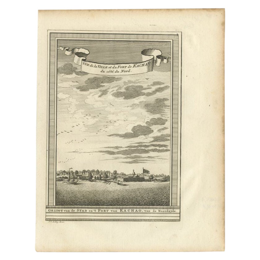
Antique Print of the City and Fortress of Kachao in Guinea Bissau, Africa, 1747
By Jakob van der Schley
Located in Langweer, NL
Antique print titled 'Gezigt van de Stad en 't Fort van Kachao'. View of the city and Fortress of Kachao, Guinea Bissau, Africa. Engraved by J. van Schley for a Dutch edition of 'l'H...
Category
Antique 18th Century Prints
Materials
Paper
$220 Sale Price
20% Off
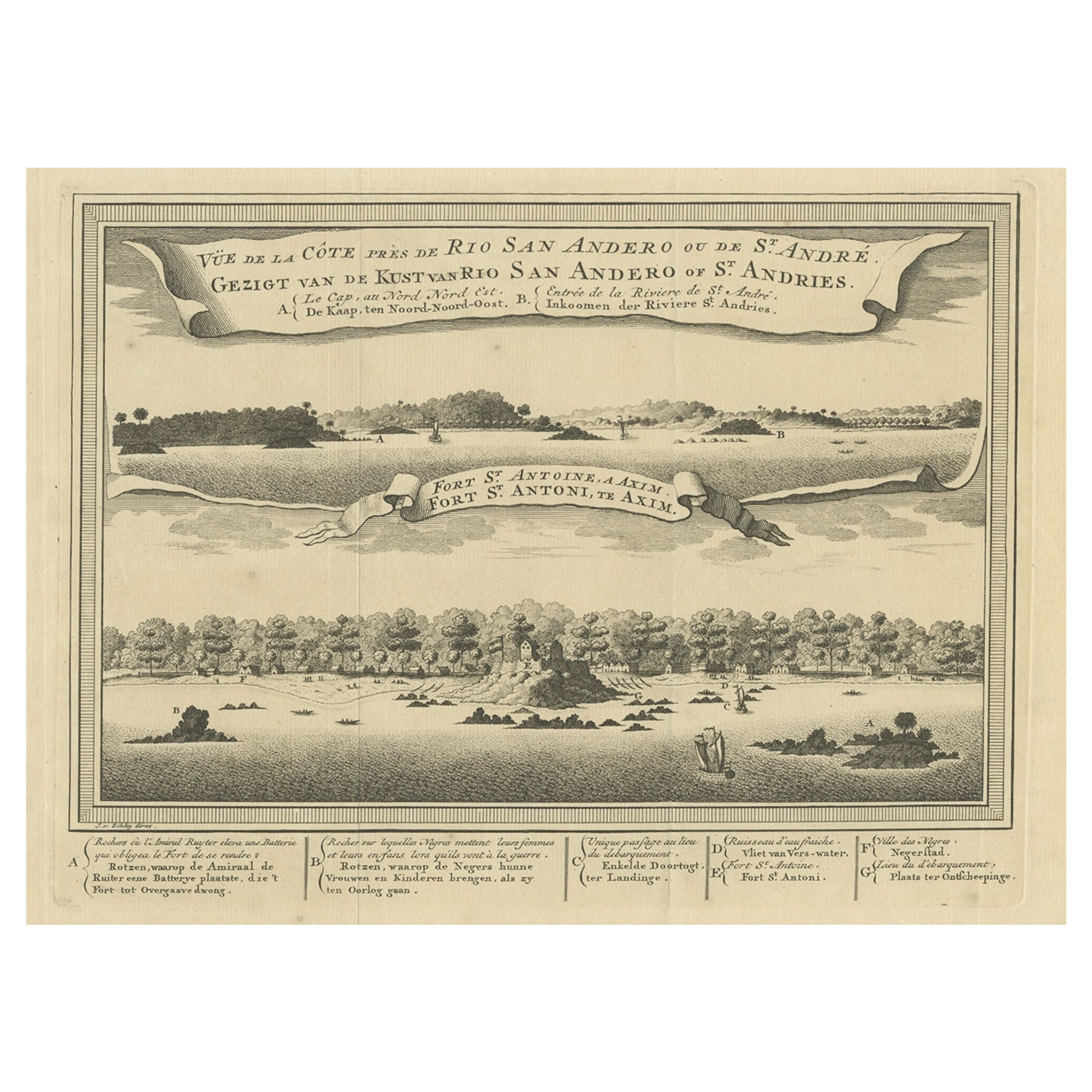
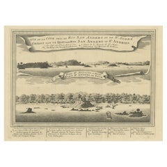
Antique Print of a Fort on the Ivory Coast and Axim, Africa, 1748
By Jakob van der Schley
Located in Langweer, NL
Antique print titled 'Vue de la Cote pres de Rio San Andero - Gezigt van de Kust van Rio San Andero' and 'Fort St. Antoine a Axim - Fort St. Antoni, te Axim'. View of the Ivory coast...
Category
Antique 18th Century Prints
Materials
Paper
$277 Sale Price
20% Off
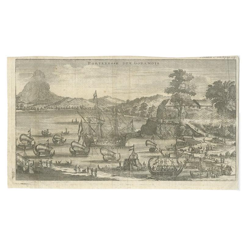
Antique Print of the Fortress of Goram by Schouten, 1725
Located in Langweer, NL
Antique print titled 'Forteresse des Goramois'. View of the fortress of Goram. Originates from 'Voyage de Gautier Schouten aux Indes Orientales (..)'.
...
Category
Antique 18th Century Prints
Materials
Paper
$124 Sale Price
20% Off
You May Also Like
Lithograph View on Nieuw Amsterdam J . Vingboons 1660s
Located in Den Haag, NL
Afther a gouache by J Vingboons 1660s Beautiful Lithograph from 1910/20
Nieuw Amsterdam ofte nue nieuw Lorx opt Teyland Man .
Very nice fresh colors . Comes with a old label on the...
Category
Antique 1650s Dutch American Colonial Prints
Materials
Paper
Original Antique Print of Cairo, Egypt. Dated 1809
Located in St Annes, Lancashire
Wonderful image of Cairo
Fine copper-plate engraving
Published by Sherwood & Co.
Dated 1809
Unframed.
Free shipping
Category
Antique Early 1800s English Moorish Prints
Materials
Paper
Antique Voc Print Holland Malaysia Old Map Melaka History, 1663
Located in Amsterdam, Noord Holland
From my own collection I offer this impressive Antique print of the city of Malakka
A very interesting piece for collectors . It is an museum piece from the Dutch Institute of Orien...
Category
Antique 17th Century European Paintings
Materials
Paper

$293 Sale Price
20% Off
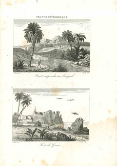
Views of Senegal - Original Lithograph - 19th century
Located in Roma, IT
Views of Senegal is an original lithograph artwork realized by an Anonymous engraver of the 19th century.
Printed in the series of "France Pittoresque".
Titled "France Pittoresqu...
Category
19th Century Modern Figurative Prints
Materials
Lithograph
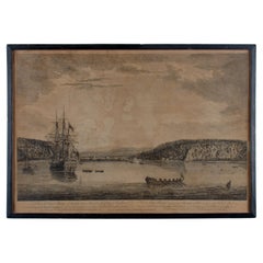
A View of Cape Rouge, Quebec, Canada, Mazell after Capt. Hervey Smyth, c.1760s
Located in Savannah, GA
A View of Cape Rouge, or Carouge, on the Saint Lawrence River, north of Quebec.
Engraving by Peter Mazell after a drawing by Captian Hervey Smyth, published c.1760's, London.
T...
Category
Antique 1760s Canadian British Colonial Prints
Materials
Paper
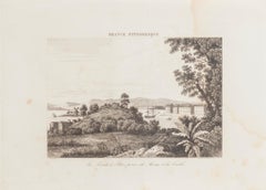
La Pointe à Pitre prise du Morne - Original Lithograph - 19th Century
Located in Roma, IT
La Pointe à Pitre prise du Morne is an original lithograph realized by an Anonymous artist of the 19th Century.
Realized within the series of "France Pittor...
Category
19th Century Landscape Prints
Materials
Lithograph
More Ways To Browse
Ralph Lauren Box
Secretary Bookcase 18th Century
Ship Needlepoint
Silk Batik
Silver Overlay Porcelain
Skater Chair
Slant Bookcase
Spades Hearts
Spanish Colonial Santos
Spanish Sword
Stork Sculpture
Studio Chora
Thomas Ivory
Tuscan Chest
Used Flat Files
Victorian Coach
Victorian Mahogany Clocks
Vintage Brass Hand Clip