Items Similar to Copperplate Engraving Showing Forts on the West African Gold Coast, Ghana, 1744
Want more images or videos?
Request additional images or videos from the seller
1 of 6
Copperplate Engraving Showing Forts on the West African Gold Coast, Ghana, 1744
$345.07
$431.3320% Off
£256.88
£321.1020% Off
€288
€36020% Off
CA$472.65
CA$590.8220% Off
A$525.69
A$657.1220% Off
CHF 274.50
CHF 343.1320% Off
MX$6,397.13
MX$7,996.4220% Off
NOK 3,505.79
NOK 4,382.2420% Off
SEK 3,287.82
SEK 4,109.7720% Off
DKK 2,192.44
DKK 2,740.5520% Off
Shipping
Retrieving quote...The 1stDibs Promise:
Authenticity Guarantee,
Money-Back Guarantee,
24-Hour Cancellation
About the Item
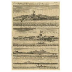
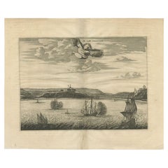
Antique print, titled: 'The Fort Fredricksburg formerly to ye Danes and now Fort Royal (…).' - A three panel copperplate engraving showing three forts on the West African Gold Coast, Ghana; a) The Fort Fredricksburgh formerly to ye Danes and now Fort Royal. English at Manfroe, b) The Fort Amsterdam at Cormentyn belonging to ye Hollanders, c) The Fort James, English at Accra. From: "A Collection of Voyages and Travels" published by John and Awnsham Churchill in London in 1744.
Artists and Engravers: Made by 'Johannes Kip' after 'A. Churchill'. Johannes Kip (b Amsterdam, 1653; d London, 1722). Dutch draughtsman, engraver and dealer, active in England. He was a pupil of Bastiaen Stopendaal (1636–1707) from 1668 to 1670. His earliest dated engravings are of 1672 (e.g. the Siege of Groningen , Hollstein, no. 4), and he supplied numerous plates for books published from that date onwards. His work brought him into contact with the court of William of Orange and in 1686 he produced six plates depicting William of Orange, his Wife and Attendants near The Hague (Hollstein, no. 5). Shortly after the Glorious Revolution of 1688 Kip followed the court to England. After settling in Westminster, he worked extensively for London publishers, engraving works after Francis Barlow, Caius Gabriel Cibber (e.g. Interior of the Danish Church in London , 1697; Hollstein, no. 6) and other London-based artists. His engravings were principally destined for book illustrations. The work for which Kip is best remembered is his large corpus of topographical engravings of country mansions, which were published first in 1708 as Britannia Illustrata: Or Views of Several of the Queen’s Palaces, as Also of the Principal Seats of the Nobility and Gentry of Great Britain, Curiously Engraven on 80 Copper Plates . This book is among the most important English topographical publications of the 18th century. The subjects were engraved by Kip after ‘bird’s-eye’ drawings executed by Leonard Knyff. The 65 folio plates of The Ancient and Present State of Gloucestershire (1712) by Sir Robert Atkyns (1647–1711), drawn and engraved by Kip, are among the finest collections of topographical illustrations in English publishing. They are also reliable illustrations of the development of the English garden. Kip also dealt in prints from his house in St John’s Street in Westminster. Awnsham Churchill (d. 1728), bookseller, was connected with the family of the Churchills of Colliton, Dorsetshire, and I was the son of William Churchill of Dorchester. He was apprenticed to Cieorge Sawbridge, and he and his brother John entered into business as booksellers and stationers at the sign of the Black Swan in Paternoster Row. They 'were of an universal trade,' says Dunton. 'I traded very considerably with them for several years ; and must do them the justice to say that I was never concerned with any persons more exact in their accompts and more just in their payments' (Life, i. 204). They published in 1695 the edition of Camden's 'Britannia' by Bishop Gibson, who used a manuscript (now lost) of John Aubrey, which he called 'Monumenta Britannica,' lent to him by Churchill, and which was preserved by the Churchill family down to the commencement of the present century. A second edition of Gibson's Camden was issued by Awnsham alone in 1722. Their next most important publication was the well-known work with which their name is usually associated : 'A Collection of Voyages and Travels, some now first printed from original MSS., others translated out of foreign languages and now first published in English ; in four volumes, witn an original preface giving an account of the progress of navigation,' &c., 1704, 4 vols, folio. It was issued to subscribers in that year, and the publishers stated that they possessed materials for two more volumes. These came out in 1732, 'printed by assignment from Messrs. Churchill.' The first four volumes were reissued (new title-pages only) in 1732 ; a ' third edition ' of the six volumes is dated 1744-6; and another by Thomas Osborne, 1752. 'A Collection from the Library of the Earl of Oxford,' London, T. Osborne, 1745 and 1747, 2 vols, folio, known as the 'Harleian Collection,' and a similar collection by John Harris (1744-8, 2 vols, folio), are usually added to Churchill's collection, making up a valuable set of reprints of voyages and travels. It is stated on the title-page of the third edition that the preliminary essay on the history of navigation is 'supposed to be written bv the celebrated Mr. Locke,' and it is includea in the works of the philosopher (1812). The authorship is doubtful, but Locke had much to do with getting together the materials of the collection, which is likely to have been produced at his instigation. Locke was upon friendly terms with Awnsham Churchill for many years, and left him a small legacy.
- Dimensions:Height: 16.07 in (40.8 cm)Width: 12.41 in (31.5 cm)Depth: 0 in (0.02 mm)
- Materials and Techniques:
- Period:1740-1749
- Date of Manufacture:1744
- Condition:Condition: Good, given age. Original folds as issued. General age-related toning and/or occasional minor defects from handling. Please study scan carefully.
- Seller Location:Langweer, NL
- Reference Number:Seller: PCT-61664 1stDibs: LU3054327483042
About the Seller
5.0
Recognized Seller
These prestigious sellers are industry leaders and represent the highest echelon for item quality and design.
Platinum Seller
Premium sellers with a 4.7+ rating and 24-hour response times
Established in 2009
1stDibs seller since 2017
2,510 sales on 1stDibs
Typical response time: <1 hour
- ShippingRetrieving quote...Shipping from: Langweer, Netherlands
- Return Policy
Authenticity Guarantee
In the unlikely event there’s an issue with an item’s authenticity, contact us within 1 year for a full refund. DetailsMoney-Back Guarantee
If your item is not as described, is damaged in transit, or does not arrive, contact us within 7 days for a full refund. Details24-Hour Cancellation
You have a 24-hour grace period in which to reconsider your purchase, with no questions asked.Vetted Professional Sellers
Our world-class sellers must adhere to strict standards for service and quality, maintaining the integrity of our listings.Price-Match Guarantee
If you find that a seller listed the same item for a lower price elsewhere, we’ll match it.Trusted Global Delivery
Our best-in-class carrier network provides specialized shipping options worldwide, including custom delivery.More From This Seller
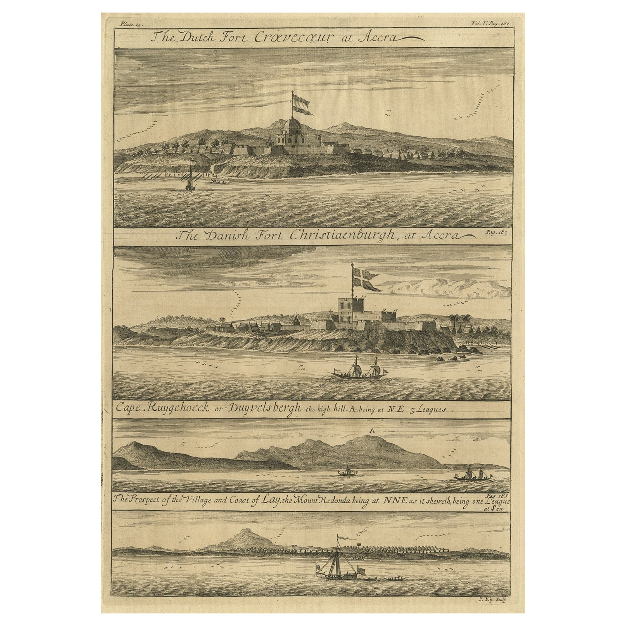
View AllRare Engraving of Dutch and Danish Forts on the West African Gold Coast, 1744
Located in Langweer, NL
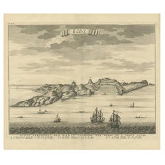
Antique print, titled: 'The Dutch Fort Croevecoeur (…).'
A four panel plate showing forts on the West African Gold Coast, Ghana; a) The Dutch Fort Croevecoeur at Accra, b) The Danish Fort Christiaenburgh at Accra, c) Cape Ruygehoeck or Duyvelsbergh, d) The Prospect of the Village and Coast of Lay, the mount Redonda being at NNE. Ussher Fort is a fort in Accra, Ghana. It was built by the Dutch in 1649 as Fort Crevecoeur. From: "A Collection of Voyages and Travels" published by John and Awnsham Churchill in London in 1744.
Artists and Engravers: Made by 'Johannes Kip' after 'A. Churchill'. Johannes Kip (b Amsterdam, 1653; d London, 1722). Dutch draughtsman, engraver and dealer, active in England. He was a pupil of Bastiaen Stopendaal (1636–1707) from 1668 to 1670. His earliest dated engravings are of 1672 (e.g. the Siege of Groningen , Hollstein, no. 4), and he supplied numerous plates for books published from that date onwards. His work brought him into contact with the court of William of Orange and in 1686 he produced six plates depicting William of Orange, his Wife and Attendants near The Hague (Hollstein, no. 5). Shortly after the Glorious Revolution of 1688 Kip followed the court to England. After settling in Westminster, he worked extensively for London publishers, engraving works after Francis Barlow, Caius Gabriel Cibber (e.g. Interior of the Danish Church in London , 1697; Hollstein, no. 6) and other London-based artists. His engravings were principally destined for book illustrations. The work for which Kip is best remembered is his large corpus...
Category
Antique 1740s Maps
Materials
Paper
$431 Sale Price
20% Off
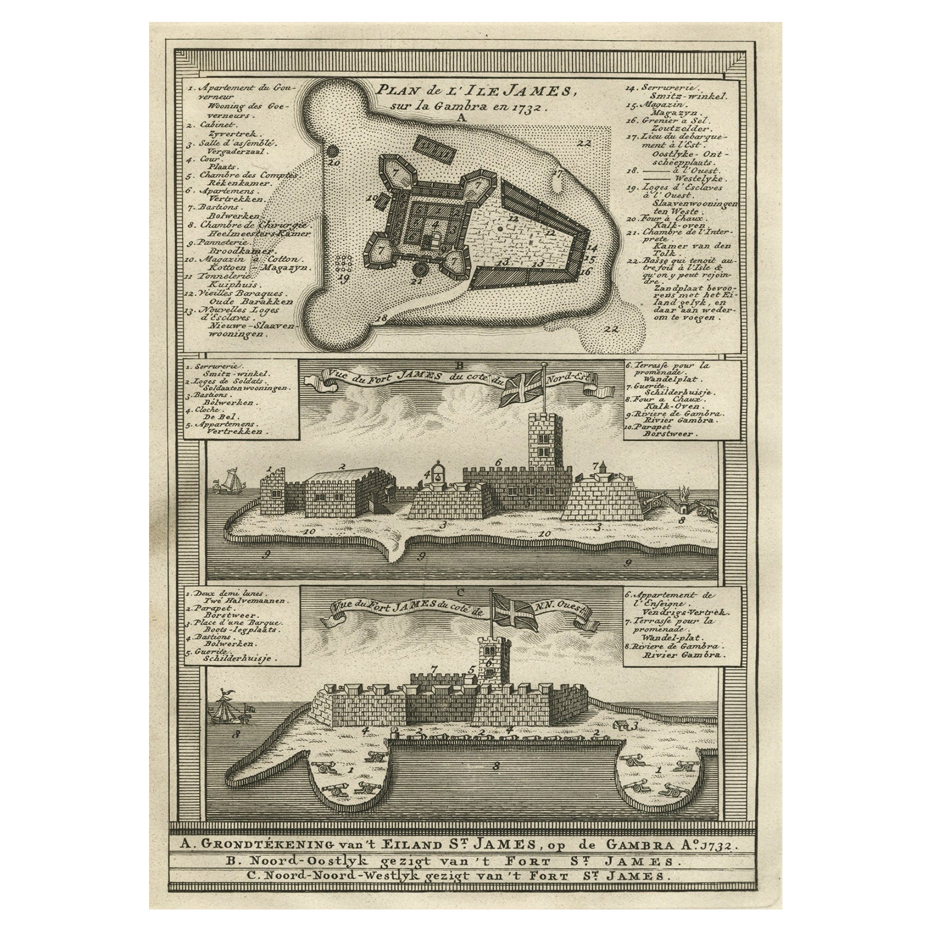
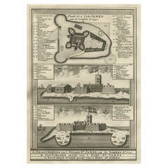
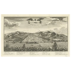
Old Copperplate Engraving of Fort St. James on the Gambra River, Africa, c.1760
Located in Langweer, NL
Plan de l’Isle James sur la Gambra en 1732 (…).
Copperplate engraving/etching on Hand laid (Verge) paper.
Sheet size: 19,7 x 26,7 cm. Image size: 13,8 x 19,8 cm.
From vol. 3 o...
Category
Antique 1760s Maps
Materials
Paper
$153 Sale Price
20% Off
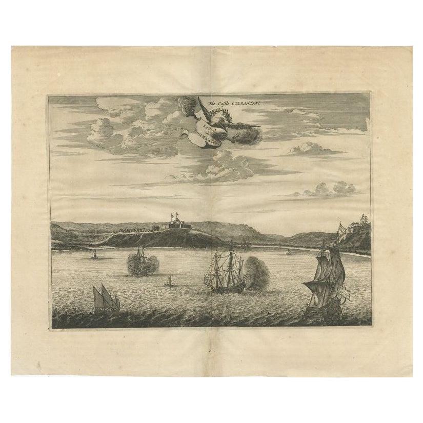
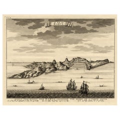
Antique Print of a Fort on the Gold Coast of Africa by Dapper, c.1670
Located in Langweer, NL
`Antique print titled 'Kasteel van Cormantin/The castle Cormantine'. Fine engraving depicting one of the forts on the Gold Coast of Africa. Cormantine Castle first was a British fort...
Category
Antique 17th Century Prints
Materials
Paper
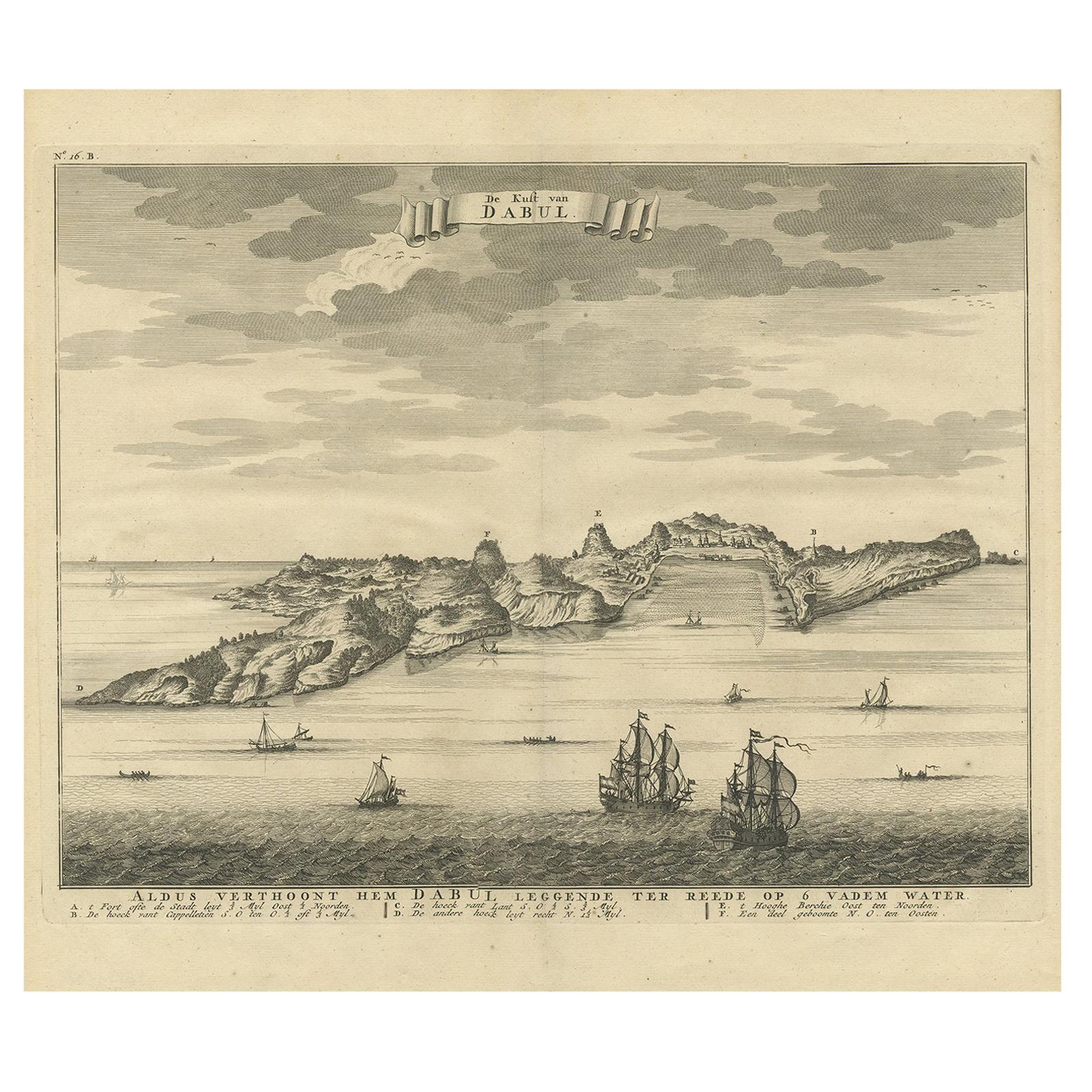
Antique Print of the Coast of Dabhol 'India', 1726
By F. Valentijn
Located in Langweer, NL
Antique print titled 'De Kust van Dabul'. Antique print of the coastline near Dabhol in India. This print originates from 'Oud en Nieuw Oost-Indiën' by F. Valentijn.
Category
Antique Early 18th Century Dutch Prints
Materials
Paper
$345 Sale Price
23% Off
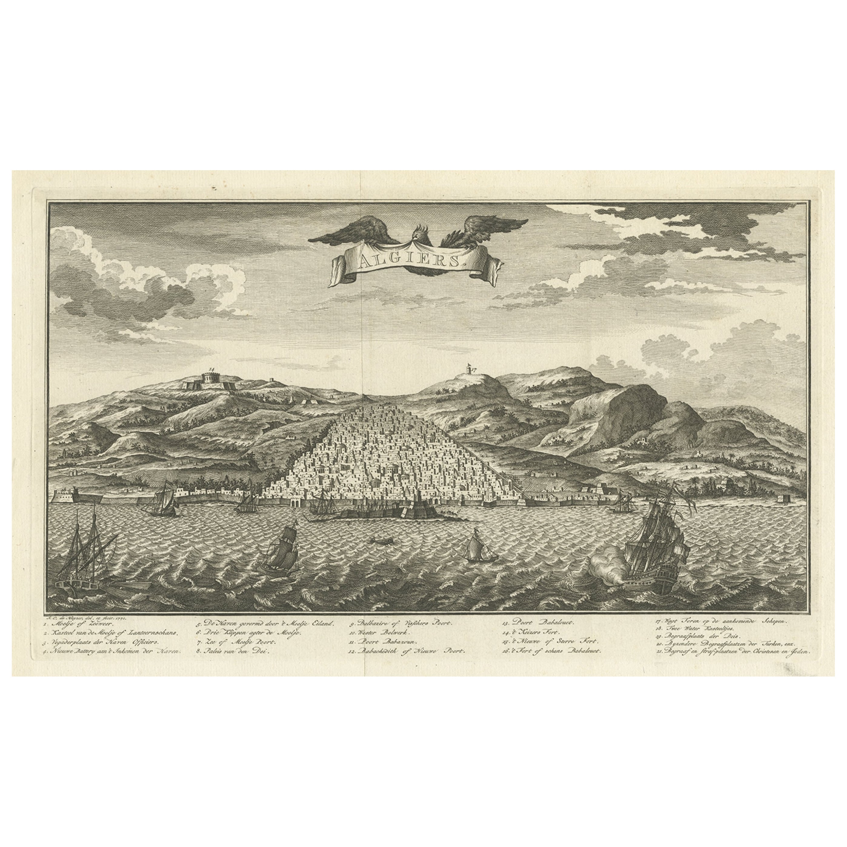
Original Antique Engraving of Algiers in Algeria, 1773
Located in Langweer, NL
Antique print titled 'Algiers'. Old print with a view of Algiers, Algeria. With Dutch legend. Originates from the first Dutch editon of an interesting travel account of Northern Afri...
Category
Antique 18th Century Prints
Materials
Paper
$469 Sale Price
20% Off
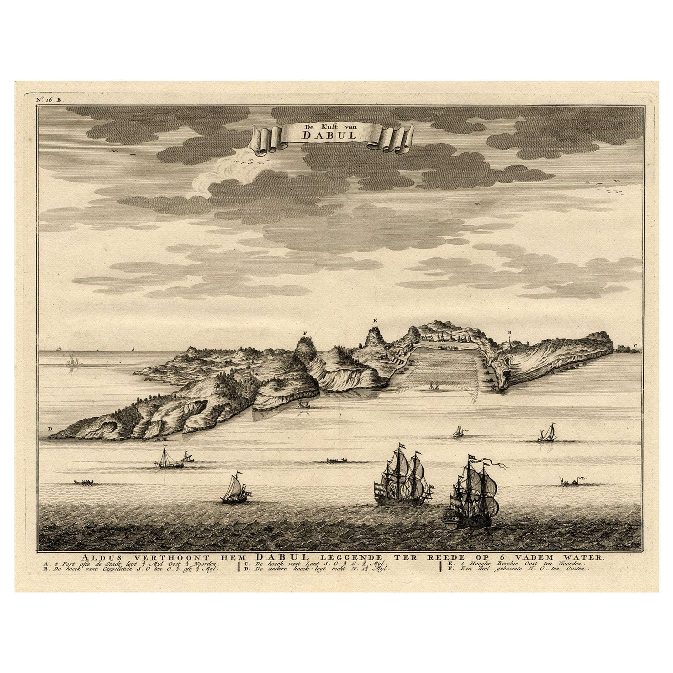
Rare Engraving of the Coast of Dabhol or Dabul, Ratnagiri, Maharashtra in India
Located in Langweer, NL
Antique print titled 'De Kust van Dabul'. Antique print depicting the coast of Dabhol / Dabul in India. This print originates from 'Oud en Nieuw Oost-Indiën' by F. Valentijn.
Artist...
Category
Antique 18th Century Prints
Materials
Paper
$613 Sale Price
20% Off
You May Also Like
17th-18th Century Siege of Graves Mapping Engraving By Willian III
Located in Kingston, NY
RARE French 17th-18th Century Enhanced Siege of Graves Mapping Engraving BY William III, also widely known as William of Orange,
The Siege of Grave in Dutch Brabant started by Monsie...
Category
Antique 17th Century French Prints
Materials
Paper

Antique Voc Print Holland Malaysia Old Map Melaka History, 1663
Located in Amsterdam, Noord Holland
From my own collection I offer this impressive Antique print of the city of Malakka
A very interesting piece for collectors . It is an museum piece from the Dutch Institute of Orien...
Category
Antique 17th Century European Paintings
Materials
Paper

$293 Sale Price
20% Off
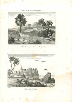
Views of Senegal - Original Lithograph - 19th century
Located in Roma, IT
Views of Senegal is an original lithograph artwork realized by an Anonymous engraver of the 19th century.
Printed in the series of "France Pittoresque".
Titled "France Pittoresqu...
Category
19th Century Modern Figurative Prints
Materials
Lithograph
West Coast of Africa, Guinea & Sierra Leone: An 18th Century Map by Bellin
By Jacques-Nicolas Bellin
Located in Alamo, CA
Jacques Bellin's copper-plate map entitled "Partie de la Coste de Guinee Dupuis la Riviere de Sierra Leona Jusquau Cap das Palmas", depicting the coast of Guinea and Sierra Leone in ...
Category
Antique Mid-18th Century French Maps
Materials
Paper

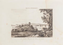
La Pointe à Pitre prise du Morne - Original Lithograph - 19th Century
Located in Roma, IT
La Pointe à Pitre prise du Morne is an original lithograph realized by an Anonymous artist of the 19th Century.
Realized within the series of "France Pittor...
Category
19th Century Landscape Prints
Materials
Lithograph
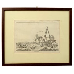
Engraving Print from the Panckoucke Encyclopédie Nautical Subject 1782-1832
Located in Milan, IT
Print by engraving on copper plate from the Panckoucke Encyclopédie méthodique, end of the 18th century,volume Marine Planches (more than 1,500 figures dealing with all subjects on the marina: planes, construction, carpentry, tree trunks, armaments of maneuvers, ropes, sails, artillery, ship maneuvers and combat tactics). This is the plate no. n. 24, pag. 69 fig. 341 ; with frame cm 38.3 x 31.5. Ship ropes are depicted. The Print has the "Benard direxit...
Category
Antique 1790s French Nautical Objects
Materials
Paper
More Ways To Browse
Library Wall Panels
John Swan
G C Denmark
Leonards Antiques
Thomas Osborne
West Country Settle
Cartier Catalog
Chamois Carved Wood
Cherry Amber
Chest Of Drawers Black Chinoiserie
Chinese Bronze Lantern
Chinese Butterfly Cabinet
Chinese Fish Plate
Chinese Water Bowl
Chinese Woodblock Print
Christophe Come
Civil War Flags
Cloud Dining Chairs