Items Similar to Rare Engraving of Dutch and Danish Forts on the West African Gold Coast, 1744

Want more images or videos?
Request additional images or videos from the seller
1 of 5
Rare Engraving of Dutch and Danish Forts on the West African Gold Coast, 1744
About the Item
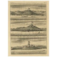
Antique print, titled: 'The Dutch Fort Croevecoeur (…).'
A four panel plate showing forts on the West African Gold Coast, Ghana; a) The Dutch Fort Croevecoeur at Accra, b) The Danish Fort Christiaenburgh at Accra, c) Cape Ruygehoeck or Duyvelsbergh, d) The Prospect of the Village and Coast of Lay, the mount Redonda being at NNE. Ussher Fort is a fort in Accra, Ghana. It was built by the Dutch in 1649 as Fort Crevecoeur. From: "A Collection of Voyages and Travels" published by John and Awnsham Churchill in London in 1744.
Artists and Engravers: Made by 'Johannes Kip' after 'A. Churchill'. Johannes Kip (b Amsterdam, 1653; d London, 1722). Dutch draughtsman, engraver and dealer, active in England. He was a pupil of Bastiaen Stopendaal (1636–1707) from 1668 to 1670. His earliest dated engravings are of 1672 (e.g. the Siege of Groningen , Hollstein, no. 4), and he supplied numerous plates for books published from that date onwards. His work brought him into contact with the court of William of Orange and in 1686 he produced six plates depicting William of Orange, his Wife and Attendants near The Hague (Hollstein, no. 5). Shortly after the Glorious Revolution of 1688 Kip followed the court to England. After settling in Westminster, he worked extensively for London publishers, engraving works after Francis Barlow, Caius Gabriel Cibber (e.g. Interior of the Danish Church in London , 1697; Hollstein, no. 6) and other London-based artists. His engravings were principally destined for book illustrations. The work for which Kip is best remembered is his large corpus of topographical engravings of country mansions, which were published first in 1708 as Britannia Illustrata: Or Views of Several of the Queen’s Palaces, as Also of the Principal Seats of the Nobility and Gentry of Great Britain, Curiously Engraven on 80 Copper Plates . This book is among the most important English topographical publications of the 18th century. The subjects were engraved by Kip after ‘bird’s-eye’ drawings executed by Leonard Knyff. The 65 folio plates of The Ancient and Present State of Gloucestershire (1712) by Sir Robert Atkyns (1647–1711), drawn and engraved by Kip, are among the finest collections of topographical illustrations in English publishing. They are also reliable illustrations of the development of the English garden. Kip also dealt in prints from his house in St John’s Street in Westminster. Awnsham Churchill (d. 1728), bookseller, was connected with the family of the Churchills of Colliton, Dorsetshire, and I was the son of William Churchill of Dorchester. He was apprenticed to Cieorge Sawbridge, and he and his brother John entered into business as booksellers and stationers at the sign of the Black Swan in Paternoster Row. They 'were of an universal trade,' says Dunton. 'I traded very considerably with them for several years ; and must do them the justice to say that I was never concerned with any persons more exact in their accompts and more just in their payments' (Life, i. 204). They published in 1695 the edition of Camden's 'Britannia' by Bishop Gibson, who used a manuscript (now lost) of John Aubrey, which he called 'Monumenta Britannica,' lent to him by Churchill, and which was preserved by the Churchill family down to the commencement of the present century. A second edition of Gibson's Camden was issued by Awnsham alone in 1722. Their next most important publication was the well-known work with which their name is usually associated : 'A Collection of Voyages and Travels, some now first printed from original MSS., others translated out of foreign languages and now first published in English ; in four volumes, witn an original preface giving an account of the progress of navigation,' &c., 1704, 4 vols, folio. It was issued to subscribers in that year, and the publishers stated that they possessed materials for two more volumes. These came out in 1732, 'printed by assignment from Messrs. Churchill.' The first four volumes were reissued (new title-pages only) in 1732 ; a ' third edition ' of the six volumes is dated 1744-6; and another by Thomas Osborne, 1752. 'A Collection from the Library of the Earl of Oxford,' London, T. Osborne, 1745 and 1747, 2 vols, folio, known as the 'Harleian Collection,' and a similar collection by John Harris (1744-8, 2 vols, folio), are usually added to Churchill's collection, making up a valuable set of reprints of voyages and travels. It is stated on the title-page of the third edition that the preliminary essay on the history of navigation is 'supposed to be written bv the celebrated Mr. Locke,' and it is includea in the works of the philosopher (1812). The authorship is doubtful, but Locke had much to do with getting together the materials of the collection, which is likely to have been produced at his instigation. Locke was upon friendly terms with Awnsham Churchill for many years, and left him a small legacy.
- Dimensions:Height: 15.36 in (39 cm)Width: 13.67 in (34.7 cm)Depth: 0 in (0.02 mm)
- Materials and Techniques:
- Period:1740-1749
- Date of Manufacture:1744
- Condition:Wear consistent with age and use. Condition: Good, given age. A few minor crinkles. Original folds as issued. General age-related toning and/or occasional minor defects from handling. Please study scan carefully.
- Seller Location:Langweer, NL
- Reference Number:
About the Seller
5.0
Platinum Seller
These expertly vetted sellers are 1stDibs' most experienced sellers and are rated highest by our customers.
Established in 2009
1stDibs seller since 2017
1,919 sales on 1stDibs
Typical response time: <1 hour
- ShippingRetrieving quote...Ships From: Langweer, Netherlands
- Return PolicyA return for this item may be initiated within 14 days of delivery.
More From This SellerView All
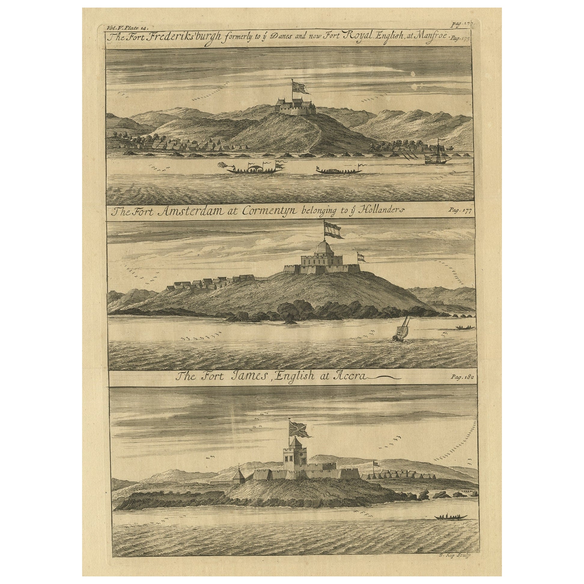
- Copperplate Engraving Showing Forts on the West African Gold Coast, Ghana, 1744Located in Langweer, NLAntique print, titled: 'The Fort Fredricksburg formerly to ye Danes and now Fort Royal (…).' - A three panel copperplate engraving showing three forts on the West African Gold Coast, Ghana; a) The Fort Fredricksburgh formerly to ye Danes and now Fort Royal. English at Manfroe, b) The Fort Amsterdam at Cormentyn belonging to ye Hollanders, c) The Fort James, English at Accra. From: "A Collection of Voyages and Travels" published by John and Awnsham Churchill in London in 1744. Artists and Engravers: Made by 'Johannes Kip' after 'A. Churchill'. Johannes Kip (b Amsterdam, 1653; d London, 1722). Dutch draughtsman, engraver and dealer, active in England. He was a pupil of Bastiaen Stopendaal (1636–1707) from 1668 to 1670. His earliest dated engravings are of 1672 (e.g. the Siege of Groningen , Hollstein, no. 4), and he supplied numerous plates for books published from that date onwards. His work brought him into contact with the court of William of Orange and in 1686 he produced six plates depicting William of Orange, his Wife and Attendants near The Hague (Hollstein, no. 5). Shortly after the Glorious Revolution of 1688 Kip followed the court to England. After settling in Westminster, he worked extensively for London publishers, engraving works after Francis Barlow, Caius Gabriel Cibber (e.g. Interior of the Danish Church in London , 1697; Hollstein, no. 6) and other London-based artists. His engravings were principally destined for book illustrations. The work for which Kip is best remembered is his large corpus...Category
Antique 1740s Prints
MaterialsPaper
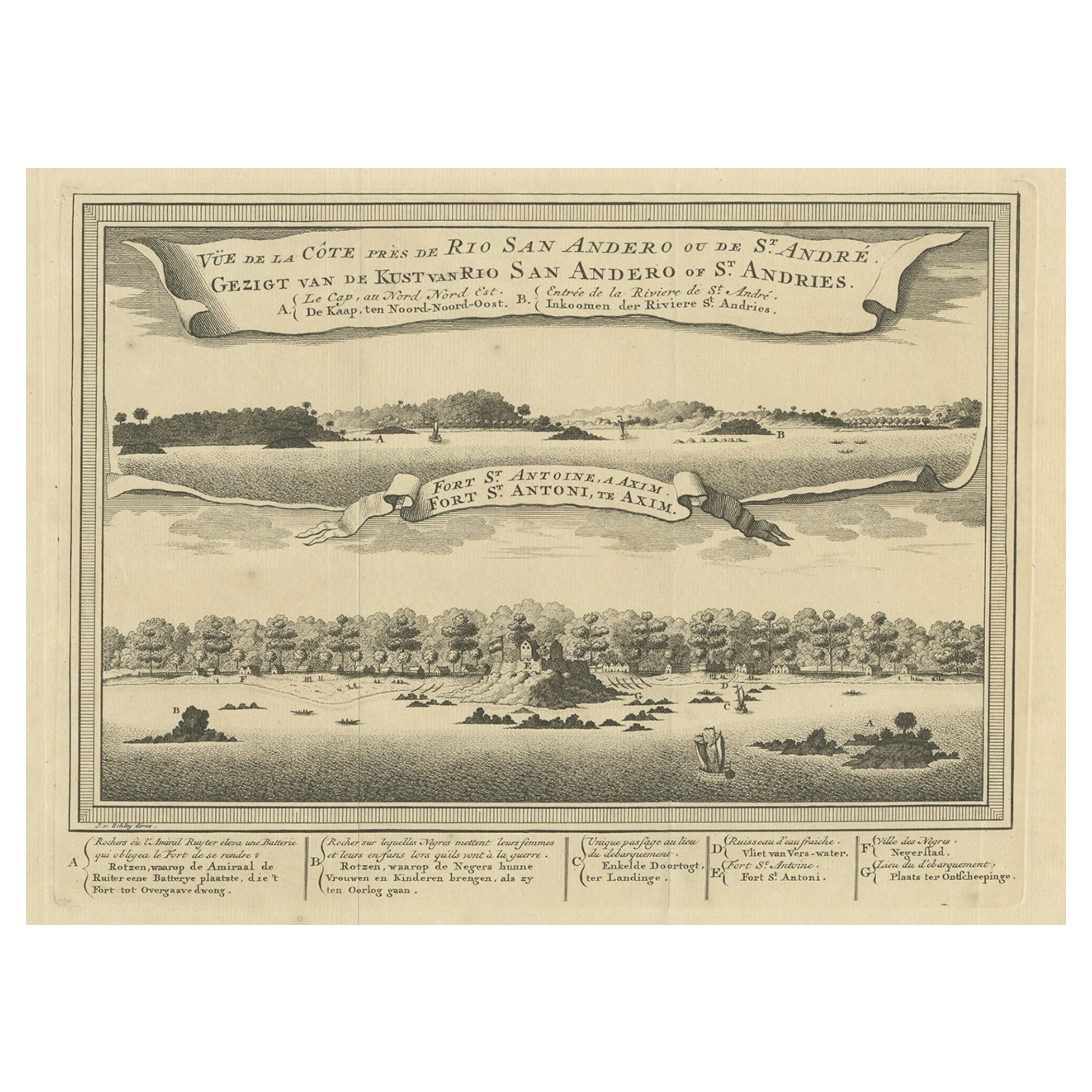
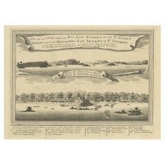
- Antique Print of a Fort on the Ivory Coast and Axim, Africa, 1748By Jakob van der SchleyLocated in Langweer, NLAntique print titled 'Vue de la Cote pres de Rio San Andero - Gezigt van de Kust van Rio San Andero' and 'Fort St. Antoine a Axim - Fort St. Antoni, te Axim'. View of the Ivory coast...Category
Antique 18th Century Prints
MaterialsPaper
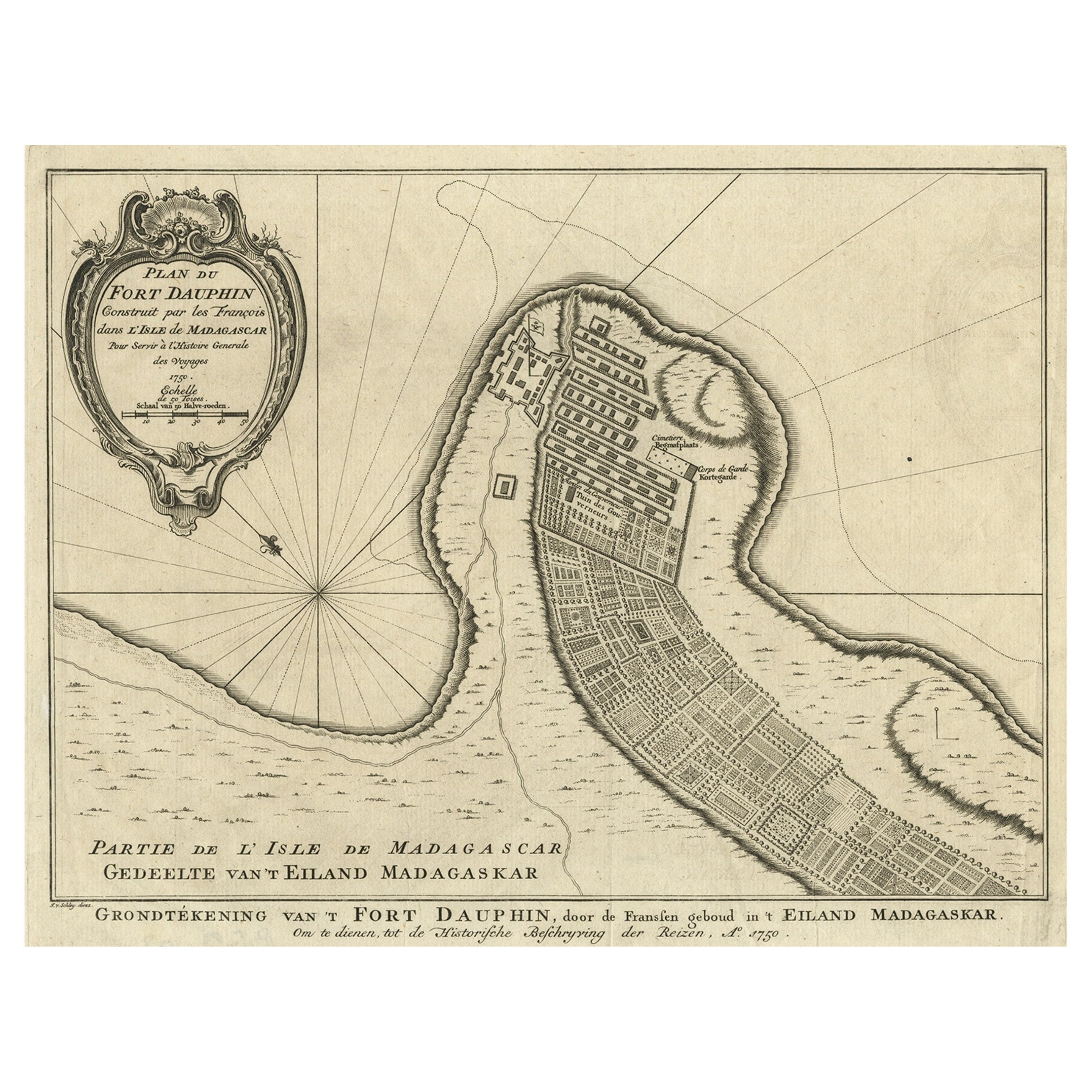
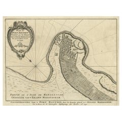
- Antique Plan of Fort Dauphin on Madagascar of the East Coast of Africa, 1756Located in Langweer, NLAntique map titled 'Plan du Fort Dauphin (..) - Grondtekening van 't Fort Dauphin'. Plan of Fort Dauphin on the island of Madagascar of the east coast of Africa. This print origi...Category
Antique 1750s Maps
MaterialsPaper
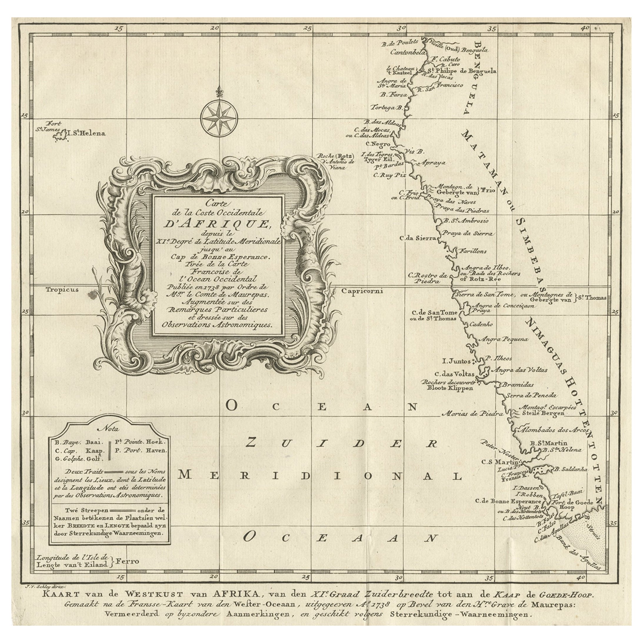
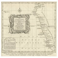
- Dutch Antique Map of the West Coast of Africa, to the Cape of Good Hope, 1747Located in Langweer, NLAntique map of the Coast of Africa titled 'Kaart van de West Kust van Afrika (..)'. Map of the west coast of Africa, from 11 degrees south latitude to the Cape of Good Hope. This...Category
Antique 1740s Maps
MaterialsPaper
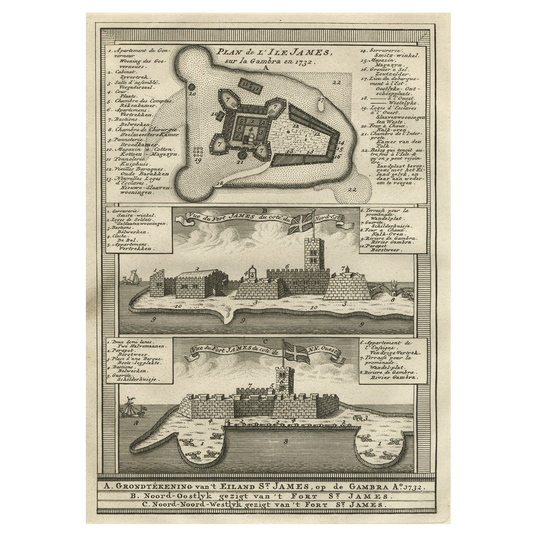
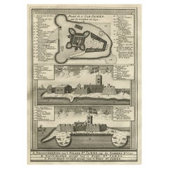
- Old Copperplate Engraving of Fort St. James on the Gambra River, Africa, c.1760Located in Langweer, NLPlan de l’Isle James sur la Gambra en 1732 (…). Copperplate engraving/etching on Hand laid (Verge) paper. Sheet size: 19,7 x 26,7 cm. Image size: 13,8 x 19,8 cm. From vol. 3 o...Category
Antique 1760s Maps
MaterialsPaper
- Antique Map of the West African Coast and the Cape Verde Islands, c.1680Located in Langweer, NLAntique map Africa titled 'Isles du Cap Verd Coste et Pays des Negres'. Antique map of the coast of Africa and the Cape Verde islands. Artists a...Category
Antique 17th Century Maps
MaterialsPaper

You May Also Like
- West Coast of Africa, Guinea & Sierra Leone: An 18th Century Map by BellinBy Jacques-Nicolas BellinLocated in Alamo, CAJacques Bellin's copper-plate map entitled "Partie de la Coste de Guinee Dupuis la Riviere de Sierra Leona Jusquau Cap das Palmas", depicting the coast of Guinea and Sierra Leone in ...Category
Antique Mid-18th Century French Maps
MaterialsPaper
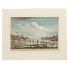
- Dutch Kolf Print, Winter, Golf EngravingLocated in Oxfordshire, GBDutch golf engraving by J. Boydell, Winter. Rare 18th century Dutch golf engraving by J. Boydell depicting Dutchman playing the early form of golf on the ice, titled 'Winter'. The s...Category
Antique 18th Century Dutch Prints
MaterialsPaper
- Italy, Sicily, Sardinia, Corsica and Dalmatian Coast: A 17th Century Dutch MapBy Theodorus DanckertsLocated in Alamo, CAThis hand colored 17th century Dutch map entitled "Novissima et Accuratissima totius Italiae Corsicae et Sardiniae Descriptio" by Theodore Danckerts depicts the Italian Peninsula in ...Category
Antique Late 17th Century Dutch Maps
MaterialsPaper
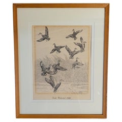
- Rare Lynn Bogue Hunt Engraving of Ducks Unlimited, 1940By Lynn Bogue HuntLocated in Dallas, TXPresenting a Rare Lynn Bogue Hunt engraving of ducks unlimited 1940. This piece cam from a wealthy estate in Dallas, TX with the mansion being built...Category
Mid-20th Century American Sporting Art Prints
MaterialsPaper
- 17th Century Hand-Colored Map of West Africa by Mercator/HondiusLocated in Alamo, CAA 17th century hand-colored map entitled "Guineae Nova Descriptio" by Gerard Mercator and Jodocus Hondius, published in their 'Atlas Minor' in Amsterdam in 1635. It is focused on the...Category
Antique Mid-17th Century Dutch Maps
MaterialsPaper
- “The Restaurant of the House of Representatives” Engraving by Harper's WeeklyLocated in Colorado Springs, COThis original wood engraving is titled “The Restaurant of the House of Representatives, Washington, DC.” It was published as a double-page image, in the August 12, 1893 issue of the famous 19th century newspaper Harper’s Weekly. The print was illustrated by Charles Stanley Reinhardt. The House Restaurant, a unique part of life in the Capitol, has been in the same location since the 1857 Capitol Expansion. Congressional members’ busy work schedule made the availability of food on site a necessity. But the restaurant also served as an informal meeting spot for members to continue conversations and deal making. This 1893 print illustrates the convivial atmosphere. Details including elegantly dressed tables...Category
Antique 1890s American Prints
MaterialsPaper


Recently Viewed
View AllMore Ways To Browse
The Denmark Collection
Africa Gold
African Gold
New West Furniture
Rare Engravings
Denmark England
Dealers Denmark
Danish Dealer
Antique Gold Engraving
Danish Library
West African Furniture
Danish Country Antiques
Antique Danish Country Furniture
Rare Book Sets
Danish Antique Country Furniture
Danish Palace
Antique Dutch Gold
Holland And Sons Furniture