Items Similar to Antique Plan of Fort Dauphin on Madagascar of the East Coast of Africa, 1756

Want more images or videos?
Request additional images or videos from the seller
1 of 5
Antique Plan of Fort Dauphin on Madagascar of the East Coast of Africa, 1756
About the Item
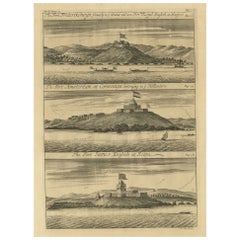
Antique map titled 'Plan du Fort Dauphin (..) -
Grondtekening van 't Fort Dauphin'. Plan of Fort Dauphin on the island of Madagascar of the east coast of Africa. This print originates from 'Historische beschryving der Reizen (..)' by P. de Hondt, 1756.
Artists and Engravers: Jakob van der Schley (Amsterdam 1715-1779) was a Dutch draughtsman and engraver. He studied under Bernard Picart and became heavily influenced by his style.
Condition: Good, given age. Original fold as issued. Light crease top left. A crease from the lower right margin into the image. General age-related toning and/or occasional minor defects from handling. Please study image carefully.
- Dimensions:Height: 9.73 in (24.7 cm)Width: 12.21 in (31 cm)Depth: 0 in (0.02 mm)
- Materials and Techniques:
- Period:1750-1759
- Date of Manufacture:1756
- Condition:
- Seller Location:Langweer, NL
- Reference Number:
About the Seller
5.0
Platinum Seller
These expertly vetted sellers are 1stDibs' most experienced sellers and are rated highest by our customers.
Established in 2009
1stDibs seller since 2017
1,919 sales on 1stDibs
Typical response time: <1 hour
- ShippingRetrieving quote...Ships From: Langweer, Netherlands
- Return PolicyA return for this item may be initiated within 14 days of delivery.
More From This SellerView All
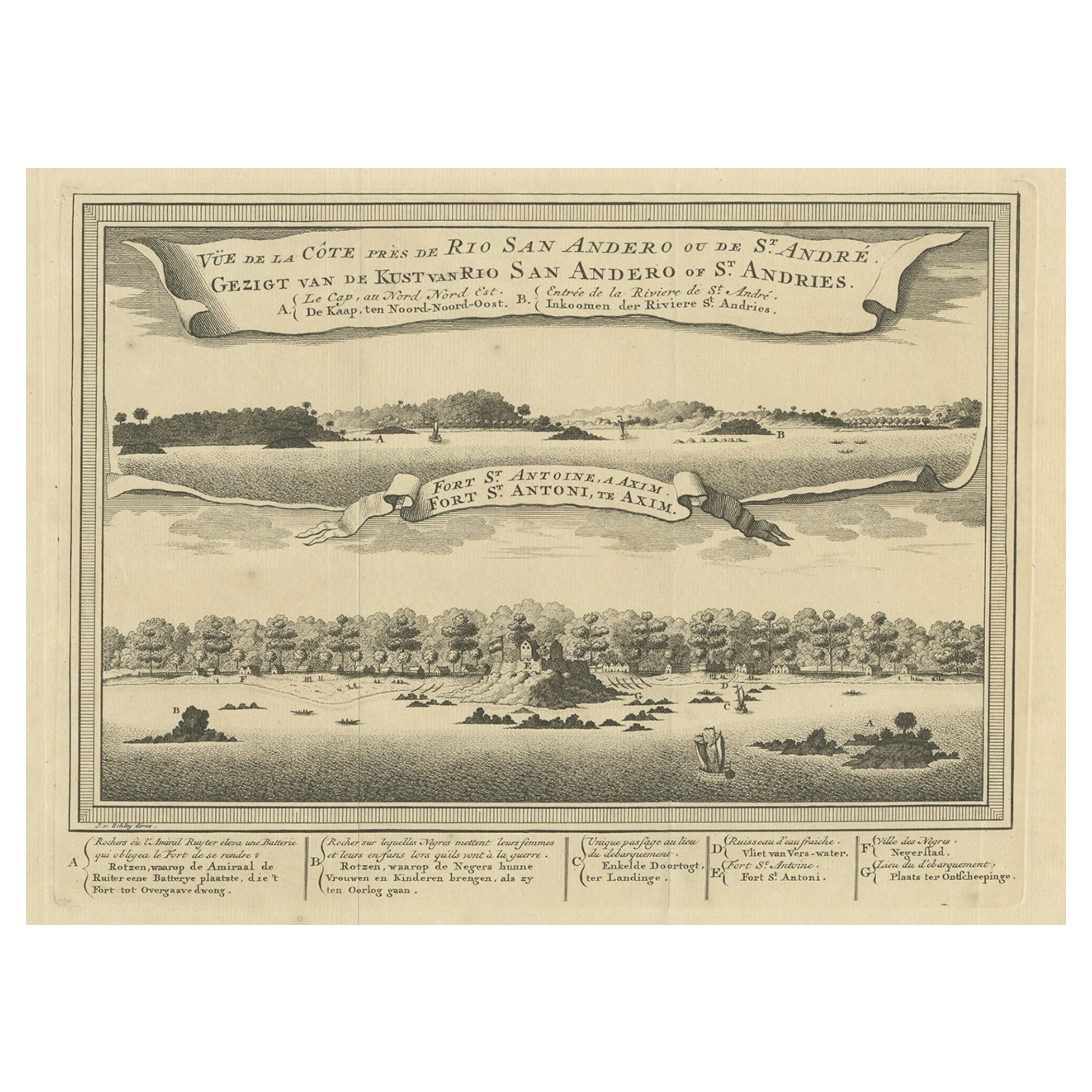
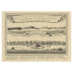
- Antique Print of a Fort on the Ivory Coast and Axim, Africa, 1748By Jakob van der SchleyLocated in Langweer, NLAntique print titled 'Vue de la Cote pres de Rio San Andero - Gezigt van de Kust van Rio San Andero' and 'Fort St. Antoine a Axim - Fort St. Antoni, te Axim'. View of the Ivory coast...Category
Antique 18th Century Prints
MaterialsPaper
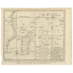
- Original Detailed Antique Map of the East Coast of Africa, 1747Located in Langweer, NLAntique map titled 'Carte de la coste Orientale d'Afrique - Kaart van de Oostkust van Afrika'. Original antique map of the east coast of Africa. Reaches from Cape of Good Hope an...Category
Antique 1740s Maps
MaterialsPaper
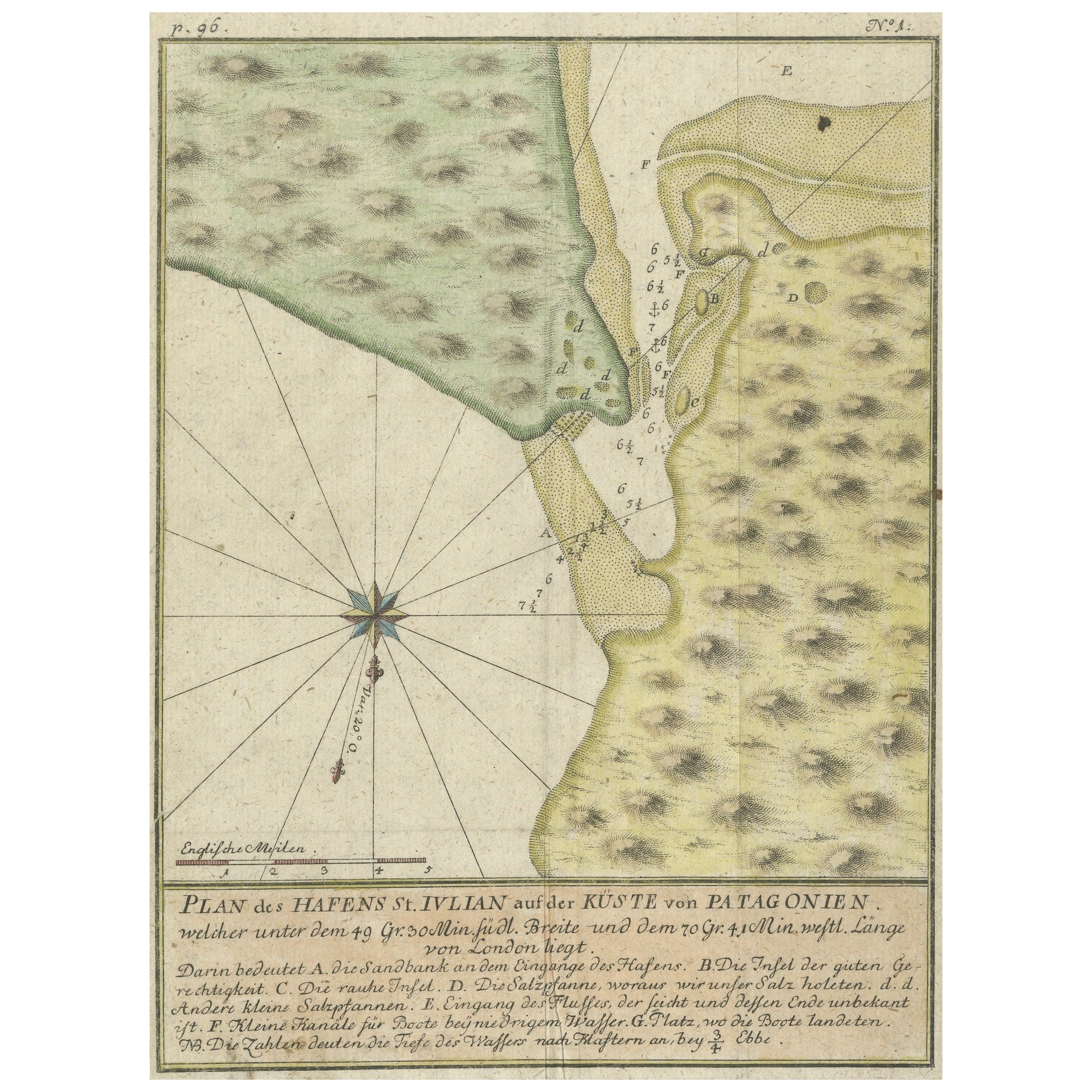
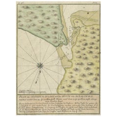
- Antique Plan of Plan of St. Julian's Harbour on the Coast of PatagoniaLocated in Langweer, NLAntique map titled 'Plan des Hafens St. Iulian auf der Küste von Patagonien'. Plan of St. Julian's Harbour on the Coast of Patagonia. This map originates from a German edition of 'Voyage around the World...Category
Antique Mid-18th Century Maps
MaterialsPaper
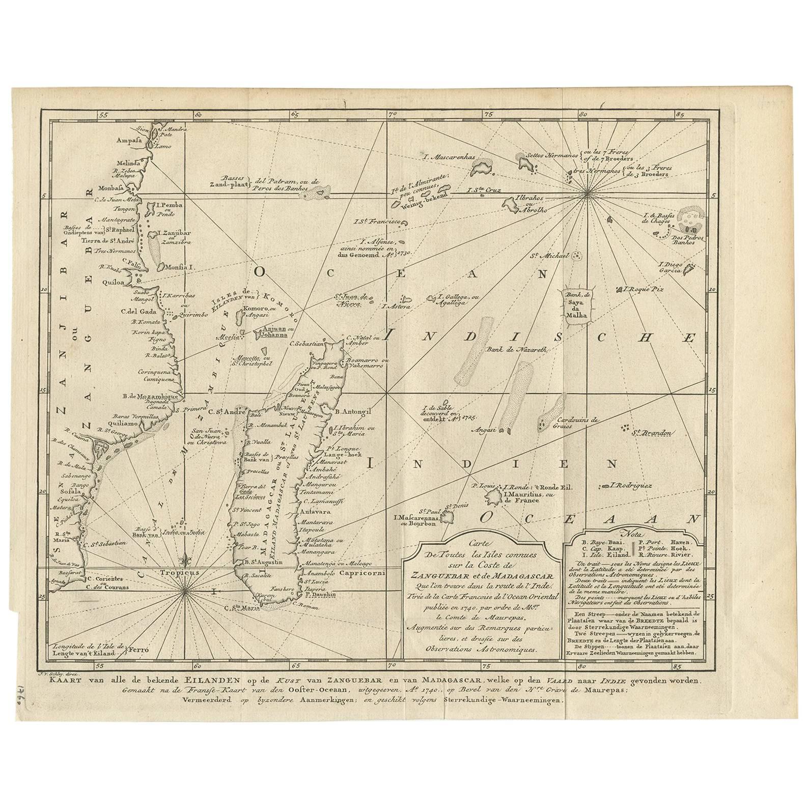
- Antique Map of the Coast of Zanguebar and Madagascar 'Africa' by J. van SchleyLocated in Langweer, NLDecorative map of the area between the east coast of South Africa, the Seychelles, Mauritius and Madagascar. It was made by Jacob van der Schley for the Dutch edition of Histoire Gén...Category
Antique Mid-18th Century Maps
MaterialsPaper
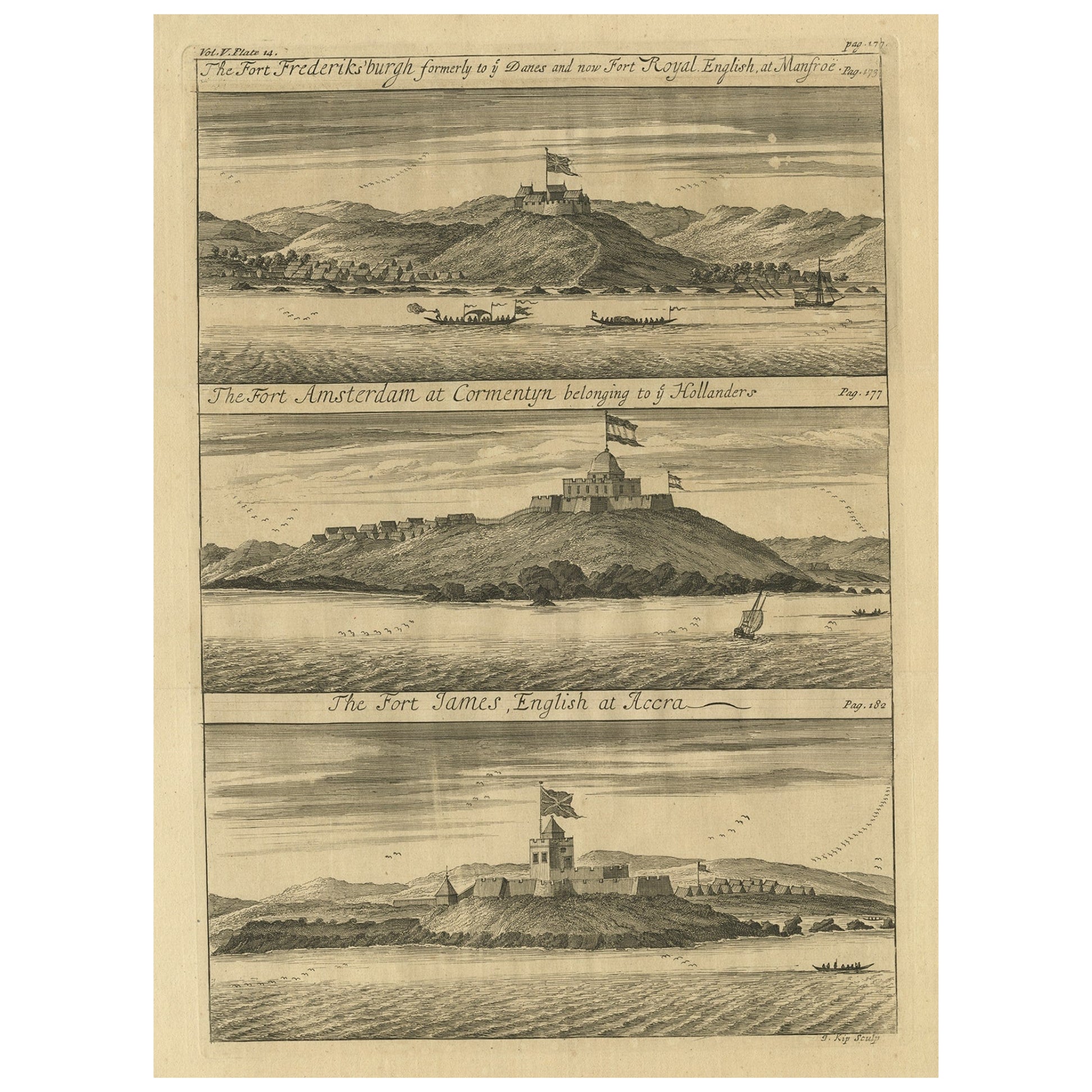
- Copperplate Engraving Showing Forts on the West African Gold Coast, Ghana, 1744Located in Langweer, NLAntique print, titled: 'The Fort Fredricksburg formerly to ye Danes and now Fort Royal (…).' - A three panel copperplate engraving showing three forts on the West African Gold Coast, Ghana; a) The Fort Fredricksburgh formerly to ye Danes and now Fort Royal. English at Manfroe, b) The Fort Amsterdam at Cormentyn belonging to ye Hollanders, c) The Fort James, English at Accra. From: "A Collection of Voyages and Travels" published by John and Awnsham Churchill in London in 1744. Artists and Engravers: Made by 'Johannes Kip' after 'A. Churchill'. Johannes Kip (b Amsterdam, 1653; d London, 1722). Dutch draughtsman, engraver and dealer, active in England. He was a pupil of Bastiaen Stopendaal (1636–1707) from 1668 to 1670. His earliest dated engravings are of 1672 (e.g. the Siege of Groningen , Hollstein, no. 4), and he supplied numerous plates for books published from that date onwards. His work brought him into contact with the court of William of Orange and in 1686 he produced six plates depicting William of Orange, his Wife and Attendants near The Hague (Hollstein, no. 5). Shortly after the Glorious Revolution of 1688 Kip followed the court to England. After settling in Westminster, he worked extensively for London publishers, engraving works after Francis Barlow, Caius Gabriel Cibber (e.g. Interior of the Danish Church in London , 1697; Hollstein, no. 6) and other London-based artists. His engravings were principally destined for book illustrations. The work for which Kip is best remembered is his large corpus...Category
Antique 1740s Prints
MaterialsPaper
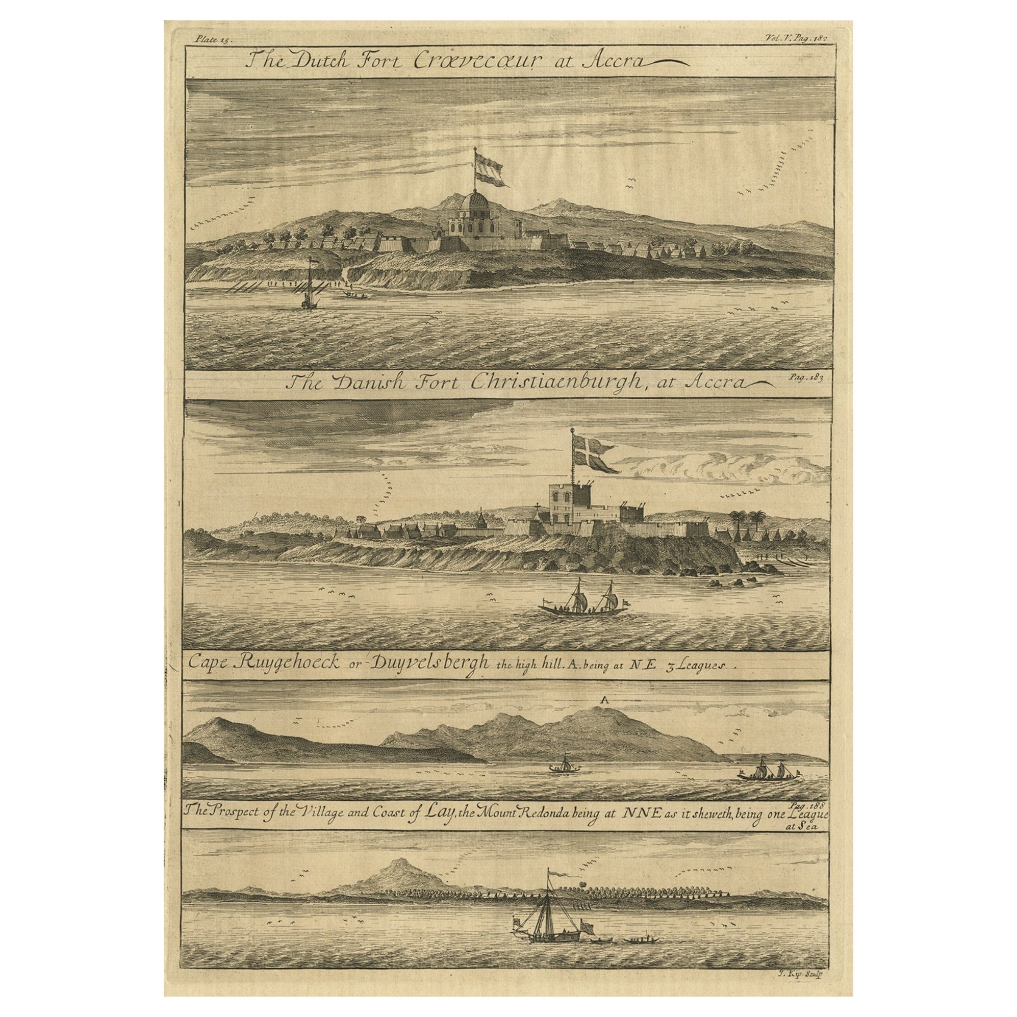
- Rare Engraving of Dutch and Danish Forts on the West African Gold Coast, 1744Located in Langweer, NLAntique print, titled: 'The Dutch Fort Croevecoeur (…).' A four panel plate showing forts on the West African Gold Coast, Ghana; a) The Dutch Fort Croevecoeur at Accra, b) The Danish Fort Christiaenburgh at Accra, c) Cape Ruygehoeck or Duyvelsbergh, d) The Prospect of the Village and Coast of Lay, the mount Redonda being at NNE. Ussher Fort is a fort in Accra, Ghana. It was built by the Dutch in 1649 as Fort Crevecoeur. From: "A Collection of Voyages and Travels" published by John and Awnsham Churchill in London in 1744. Artists and Engravers: Made by 'Johannes Kip' after 'A. Churchill'. Johannes Kip (b Amsterdam, 1653; d London, 1722). Dutch draughtsman, engraver and dealer, active in England. He was a pupil of Bastiaen Stopendaal (1636–1707) from 1668 to 1670. His earliest dated engravings are of 1672 (e.g. the Siege of Groningen , Hollstein, no. 4), and he supplied numerous plates for books published from that date onwards. His work brought him into contact with the court of William of Orange and in 1686 he produced six plates depicting William of Orange, his Wife and Attendants near The Hague (Hollstein, no. 5). Shortly after the Glorious Revolution of 1688 Kip followed the court to England. After settling in Westminster, he worked extensively for London publishers, engraving works after Francis Barlow, Caius Gabriel Cibber (e.g. Interior of the Danish Church in London , 1697; Hollstein, no. 6) and other London-based artists. His engravings were principally destined for book illustrations. The work for which Kip is best remembered is his large corpus...Category
Antique 1740s Maps
MaterialsPaper


You May Also Like
- Chart of the East Coast of EnglandLocated in Norwell, MAChart of the East Coast of England, from Dungeness to Flamborough, including the entrances to the Thames River. Drawn by hydrographer J.W. Norie in 1841. Includes Kent, Essex and Suf...Category
Antique 1840s English Nautical Objects
MaterialsPaper
- West Coast of Africa, Guinea & Sierra Leone: An 18th Century Map by BellinBy Jacques-Nicolas BellinLocated in Alamo, CAJacques Bellin's copper-plate map entitled "Partie de la Coste de Guinee Dupuis la Riviere de Sierra Leona Jusquau Cap das Palmas", depicting the coast of Guinea and Sierra Leone in ...Category
Antique Mid-18th Century French Maps
MaterialsPaper
- Original Antique Map of South East Asia, Arrowsmith, 1820Located in St Annes, LancashireGreat map of South East Asia Drawn under the direction of Arrowsmith Copper-plate engraving Published by Longman, Hurst, Rees, Orme and Brown, 1820 Unframed.Category
Antique 1820s English Maps
MaterialsPaper
- Original Antique Map of South East Asia by Becker, circa 1840Located in St Annes, LancashireGreat map of South East Asia Steel engraving with original color outline Engraved by Becker Published by Virtue, circa 1840. Unframed.Category
Antique 1840s English Other Maps
MaterialsPaper
- Original Antique Map of South East Asia by Thomas Clerk, 1817Located in St Annes, LancashireGreat map of South East Asia Copper-plate engraving Drawn and engraved by Thomas Clerk, Edinburgh. Published by Mackenzie And Dent, 1817 Unframed.Category
Antique 1810s English Maps
MaterialsPaper
- Original Antique English County Map, East Yorkshire, J & C Walker, 1851Located in St Annes, LancashireGreat map of The East Riding of Yorkshire Original colour By J & C Walker Published by Longman, Rees, Orme, Brown & Co. 1851 Unframed.Category
Antique 1850s English Other Maps
MaterialsPaper


Recently Viewed
View AllMore Ways To Browse
Antique Plan
Antique Plans
African P
Bernard T
East Coast Antiques
East Africa Map
Madagascar Antique Map
Map Of Madagascar
Antique Furniture East London
Antique Eastern European Furniture
Vintage Map Of The United States
Antique House Plans
Antique Metal Window
Antique Metal Windows
Antique Furniture Rollers
Antiques Compasses
India Map
Antique Maps Book