Items Similar to Original Detailed Antique Map of the East Coast of Africa, 1747

Want more images or videos?
Request additional images or videos from the seller
1 of 5
Original Detailed Antique Map of the East Coast of Africa, 1747
About the Item
Antique map titled 'Carte de la coste Orientale d'Afrique - Kaart van de Oostkust van Afrika'.
Original antique map of the east coast of Africa. Reaches from Cape of Good Hope and the land of the Hottentots in the south to northern Mozambique. To the east is a bit of Madagascar and surrounding islands to be seen. This map originates from 'Historische beschryving der Reizen' published by P. de Hondt.
Artists and Engravers: Jacob van der Schley was a dutch engraver and artist, who studied under the French engraver Bernard Picart (1673-1733) since he was 12.
Condition: Good, small tear upper right. Original plate mark visible. Original folds, as issued. Please study scan carefully.
- Dimensions:Height: 11.89 in (30.2 cm)Width: 9.45 in (24 cm)Depth: 0 in (0.02 mm)
- Materials and Techniques:
- Period:1740-1749
- Date of Manufacture:1747
- Condition:Minor structural damages.
- Seller Location:Langweer, NL
- Reference Number:
About the Seller
5.0
Platinum Seller
These expertly vetted sellers are 1stDibs' most experienced sellers and are rated highest by our customers.
Established in 2009
1stDibs seller since 2017
1,919 sales on 1stDibs
Typical response time: <1 hour
- ShippingRetrieving quote...Ships From: Langweer, Netherlands
- Return PolicyA return for this item may be initiated within 14 days of delivery.
More From This SellerView All
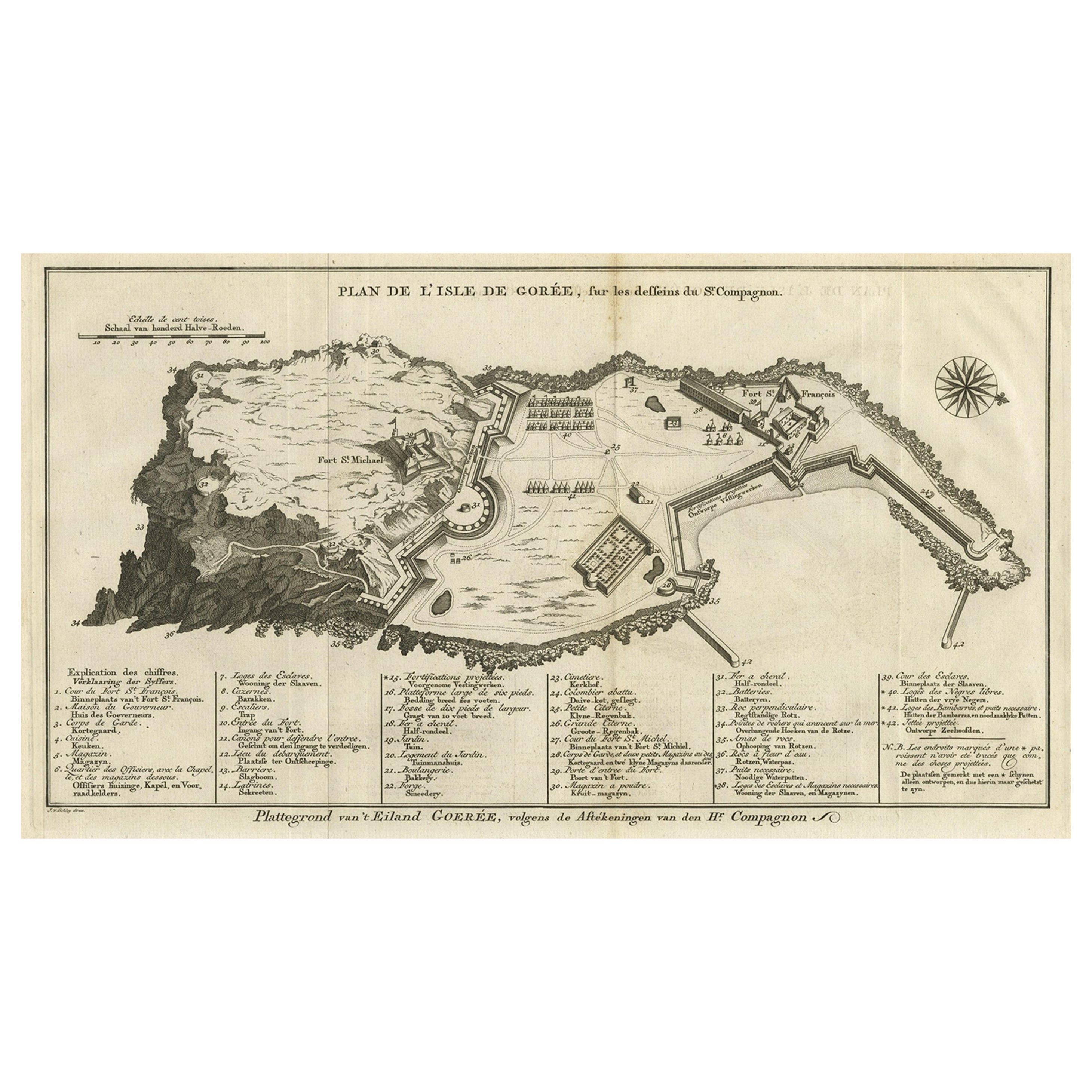
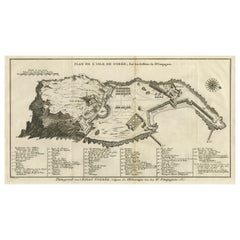
- Detailed Map of the Island of Gorée off of the Coast of Dakar, Senegal, 1747Located in Langweer, NLAntique plan titled 'Plan de l'Isle de Goree The island of Gorée lies off the coast of Senegal, opposite Dakar. From the 15th to the 19th century, it was the largest slave-tradin...Category
Antique 1740s Maps
MaterialsPaper
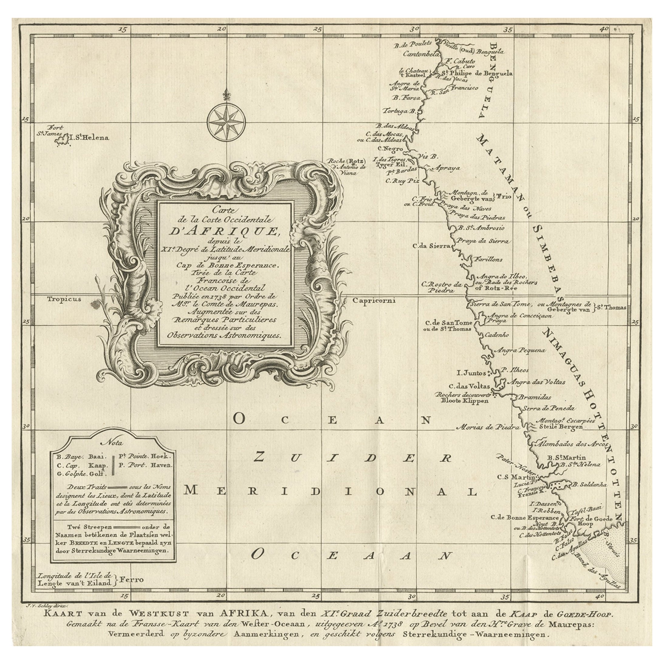
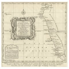
- Dutch Antique Map of the West Coast of Africa, to the Cape of Good Hope, 1747Located in Langweer, NLAntique map of the Coast of Africa titled 'Kaart van de West Kust van Afrika (..)'. Map of the west coast of Africa, from 11 degrees south latitude to the Cape of Good Hope. This...Category
Antique 1740s Maps
MaterialsPaper
- Antique Map of the East Coast of Sumatra , Indonesia, 1900Located in Langweer, NLAntique map of the East Coast of Sumatra. Also depicting the Strait of Malacca. This map originates from 'Atlas van Nederlandsch Oost- en West-Indië' by I. Dornseiffen. Artists and...Category
20th Century Maps
MaterialsPaper
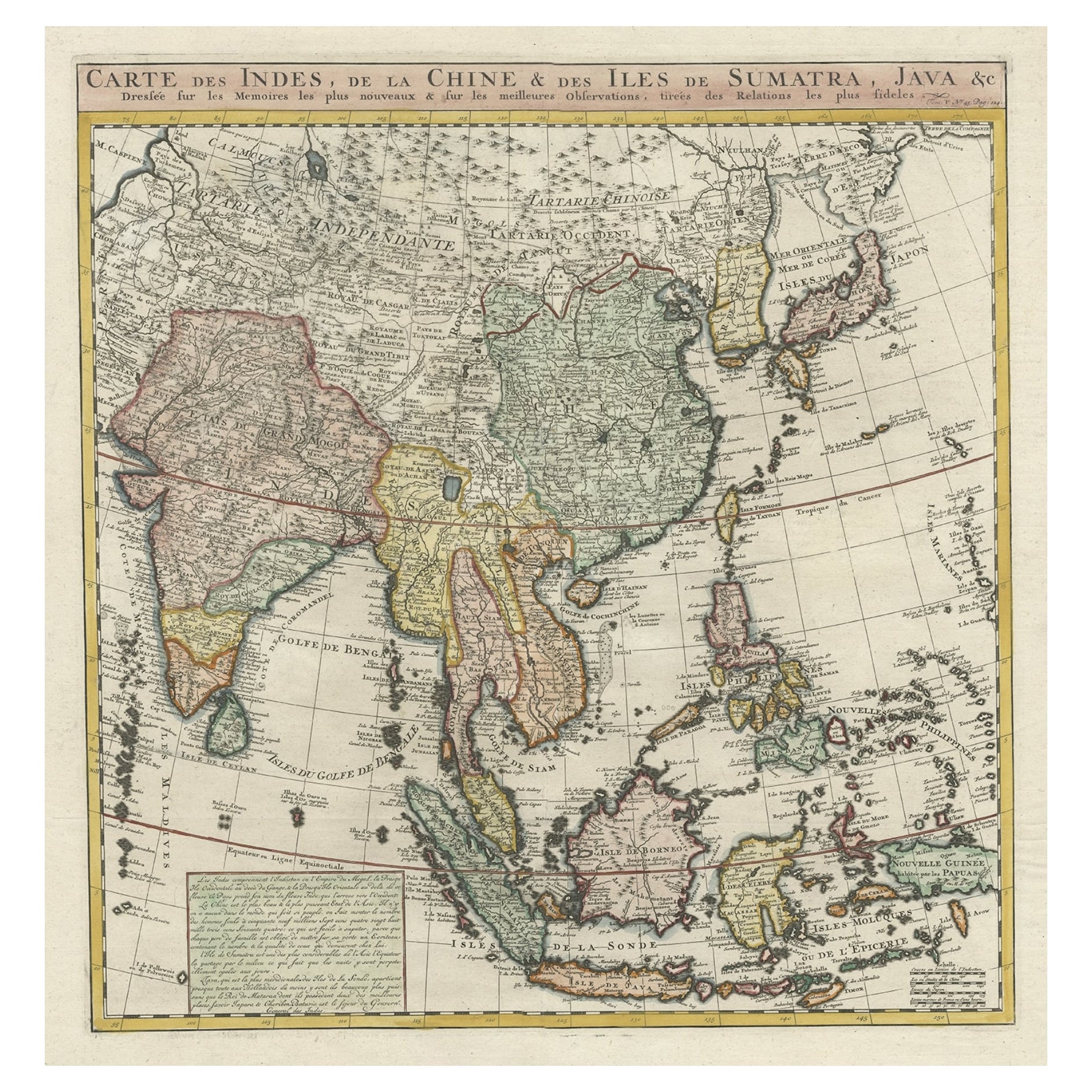
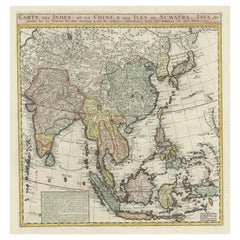
- Detailed Original Antique Map of India, Southeast Asia and the Far East, 1719Located in Langweer, NLAntique map titled 'Carte des Indes, de la Chine & des Iles de Sumatra, Java & c'. Detailed map of India, Southeast Asia and the Far East, extending from Gujerat to the supposed "T...Category
Antique 1710s Maps
MaterialsPaper
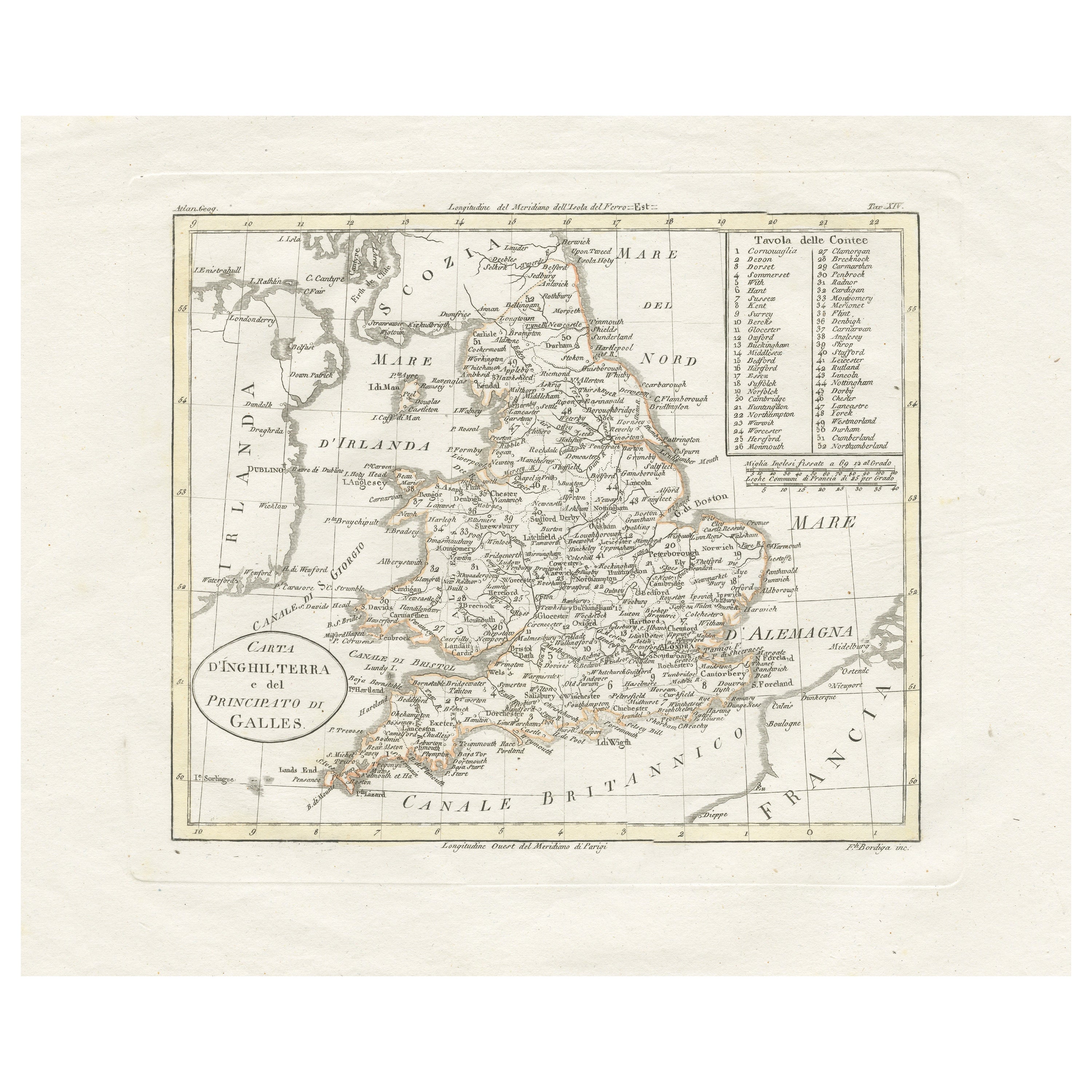
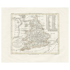
- Detailed Antique Map of Britain, Wales and the Coast of IrelandLocated in Langweer, NLAntique map titled 'Carta d'Inghilterra e del Principato di Galles'. Detailed map of Britain, Wales and the coast of Ireland with a list of counties. This map originates from 'Nuovo ...Category
Antique Mid-19th Century Maps
MaterialsPaper
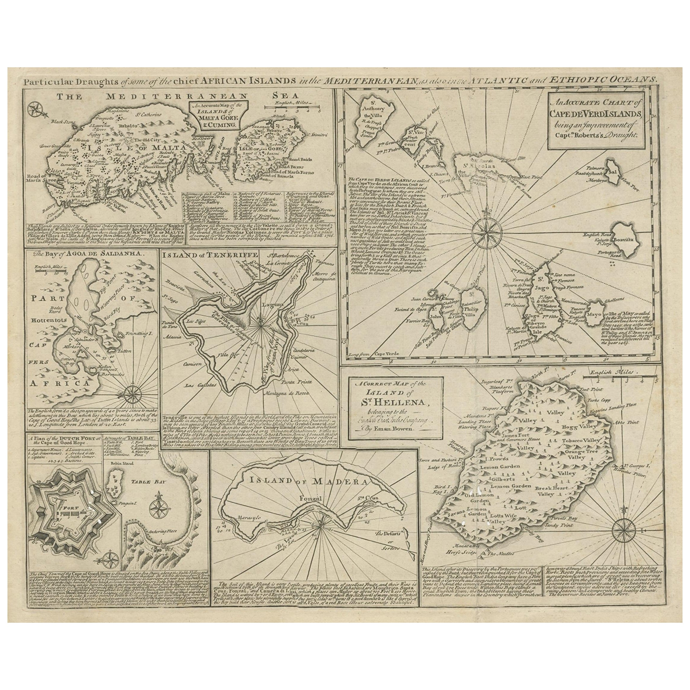
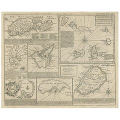
- Antique Map of 'African' Islands in the Mediterranean Sea and The Atlantic, 1747Located in Langweer, NLAntique map titled 'Particular draughts of some of the chief African Islands in the Mediterranean (..)'. Detailed set of eight maps, including a large and detailed Malta, the Bay of Agoa de Saldanha, Tenerife, the Dutch Fortress at the Cape of Good Hope, Table Bay...Category
Antique 18th Century Maps
MaterialsPaper

You May Also Like
- Original Antique Map of South Africa, Arrowsmith, 1820Located in St Annes, LancashireGreat map of South Africa. Drawn under the direction of Arrowsmith. Copper-plate engraving. Published by Longman, Hurst, Rees, Orme and Br...Category
Antique 1820s English Maps
MaterialsPaper
- Original Antique Map of South East Asia, Arrowsmith, 1820Located in St Annes, LancashireGreat map of South East Asia Drawn under the direction of Arrowsmith Copper-plate engraving Published by Longman, Hurst, Rees, Orme and Brown, 1820 Unframed.Category
Antique 1820s English Maps
MaterialsPaper
- Original Antique Map of South East Asia by Becker, circa 1840Located in St Annes, LancashireGreat map of South East Asia Steel engraving with original color outline Engraved by Becker Published by Virtue, circa 1840. Unframed.Category
Antique 1840s English Other Maps
MaterialsPaper
- Original Antique Map of South East Asia by Thomas Clerk, 1817Located in St Annes, LancashireGreat map of South East Asia Copper-plate engraving Drawn and engraved by Thomas Clerk, Edinburgh. Published by Mackenzie And Dent, 1817 Unframed.Category
Antique 1810s English Maps
MaterialsPaper
- West Coast of Africa, Guinea & Sierra Leone: An 18th Century Map by BellinBy Jacques-Nicolas BellinLocated in Alamo, CAJacques Bellin's copper-plate map entitled "Partie de la Coste de Guinee Dupuis la Riviere de Sierra Leona Jusquau Cap das Palmas", depicting the coast of Guinea and Sierra Leone in ...Category
Antique Mid-18th Century French Maps
MaterialsPaper
- Original Antique Map of Italy. C.1780Located in St Annes, LancashireGreat map of Italy Copper-plate engraving Published C.1780 Unframed.Category
Antique Early 1800s English Georgian Maps
MaterialsPaper


Recently Viewed
View AllMore Ways To Browse
South African Antique
African Plate
Map Of South Of France
South African Antique Furniture
Antique Furniture South Africa
Africa Map Antique
Antique Africa Maps
Antique African Maps
Antique Africa Map
Antique African Map
Africa Antique Map
Antique Maps Africa
Antique Map Africa
Antique Map Of Africa
Antique Maps Of Africa
Antique Furniture In South Africa
A La Carte
Map South Africa