Items Similar to Earthquakes and Volcanoes Map by A.K. Johnston – Seismic Activity Atlas 1852


Want more images or videos?
Request additional images or videos from the seller
1 of 10
Earthquakes and Volcanoes Map by A.K. Johnston – Seismic Activity Atlas 1852
$306.44per item
£230.81per item
€260per item
CA$422.60per item
A$474.77per item
CHF 248.07per item
MX$5,794.77per item
NOK 3,149.73per item
SEK 2,964.81per item
DKK 1,979.02per item
Quantity
About the Item
Earthquakes and Volcanoes Map by A.K. Johnston – Seismic Activity Atlas 1852
This extraordinary 1852 scientific map titled "The Distribution of Earthquakes & Volcanoes Over the Globe" was created by the renowned Scottish cartographer Alexander Keith Johnston and published by William Blackwood & Sons of Edinburgh and London. Issued as Plate 11 in the acclaimed *Physical Atlas of Natural Phenomena*, this plate visually captures one of the earliest attempts to chart the global geography of seismic and volcanic activity with scientific precision.
The map uses a variety of symbols and visual codes to identify known volcanic chains, active volcanoes (highlighted in red), and historically significant earthquake zones. It offers a comprehensive overview of the Pacific Ring of Fire, the volcanic arcs of the East Indies, Mediterranean seismic belts, and tectonically active zones in the Americas, Asia, and the South Pacific. Descriptive labels cite historic eruptions and earthquake events, making the map both an analytical tool and a chronicle of geophysical history.
In addition to the global map, a striking comparative diagram runs along the bottom of the sheet, showing the principal mountains of the world arranged by height and geographical longitude. Volcanoes are rendered in profile and color-coded, with active volcanoes such as Etna, Vesuvius, Cotopaxi, and Mauna Loa clearly marked. This lower section acts as a visual cross-reference between elevation and geophysical phenomena.
Johnston’s groundbreaking approach to thematic mapping helped popularize the visualization of scientific knowledge. As Geographer in Ordinary to Queen Victoria in Scotland, he was among the first to merge statistical information and natural sciences into a visual medium accessible to scholars, educators, and the general public.
This map remains a valuable historical artifact in the evolution of geology and seismology. Its unique combination of technical data and beautiful engraving make it ideal for collectors of early scientific illustrations, antique atlases, or educational wall art.
Condition and framing tips:
Very good antique condition with a clean image field and light marginal toning. Original centerfold present. Frame in black or natural wood with a soft ivory or parchment-toned mat to emphasize the refined linework and muted color scheme. Well suited to a study, library, or educational space.
- Dimensions:Height: 13.59 in (34.5 cm)Width: 10.79 in (27.4 cm)Depth: 0.01 in (0.2 mm)
- Materials and Techniques:
- Place of Origin:
- Period:
- Date of Manufacture:1852
- Condition:Very good condition. Light overall toning near the margins. The paper remains strong and well-preserved. Folding line as issued.
- Seller Location:Langweer, NL
- Reference Number:Seller: BG-13207-111stDibs: LU3054345389292
About the Seller
5.0
Recognized Seller
These prestigious sellers are industry leaders and represent the highest echelon for item quality and design.
Platinum Seller
Premium sellers with a 4.7+ rating and 24-hour response times
Established in 2009
1stDibs seller since 2017
2,533 sales on 1stDibs
Typical response time: <1 hour
- ShippingRetrieving quote...Shipping from: Langweer, Netherlands
- Return Policy
Authenticity Guarantee
In the unlikely event there’s an issue with an item’s authenticity, contact us within 1 year for a full refund. DetailsMoney-Back Guarantee
If your item is not as described, is damaged in transit, or does not arrive, contact us within 7 days for a full refund. Details24-Hour Cancellation
You have a 24-hour grace period in which to reconsider your purchase, with no questions asked.Vetted Professional Sellers
Our world-class sellers must adhere to strict standards for service and quality, maintaining the integrity of our listings.Price-Match Guarantee
If you find that a seller listed the same item for a lower price elsewhere, we’ll match it.Trusted Global Delivery
Our best-in-class carrier network provides specialized shipping options worldwide, including custom delivery.More From This Seller
View AllWind and Hurricane Map by A.K. Johnston – Meteorological Chart 1852
Located in Langweer, NL
Wind and Hurricane Map by A.K. Johnston – Meteorological Chart 1852
This scientifically significant 1852 map titled "The Distribution of the Constant, Periodical & Variable Winds Ov...
Category
Antique Mid-19th Century Scottish Prints
Materials
Paper

Antique Map showing Isotherm Lines throughout the World by Johnston '1850'
Located in Langweer, NL
Antique map titled 'Humboldt's System of Isothermal Lines'. Original antique map showing isotherm lines throughout the world. This map originates from 'The Physical Atlas of Natural ...
Category
Antique Mid-19th Century Maps
Materials
Paper

$188 Sale Price
20% Off
Antique Map Showing the Distribution of the Currents of Air by Johnston '1850'
Located in Langweer, NL
Antique map titled 'Geographical Distribution of the Currents of Air'. Original antique map showing the distribution of the currents of air. This map originates from 'The Physical At...
Category
Antique Mid-19th Century Maps
Materials
Paper

$188 Sale Price
20% Off
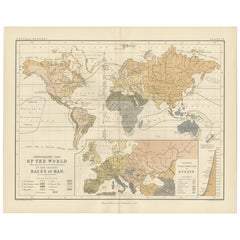
Ethnographic Map of the World by A.K. Johnston – Races of Man Chart 1852
Located in Langweer, NL
Ethnographic Map of the World by A.K. Johnston – Races of Man Chart 1852
This antique map titled "Ethnographic Map of the World Showing the Present Distribution of the Leading Races...
Category
Antique Mid-19th Century Scottish Prints
Materials
Paper
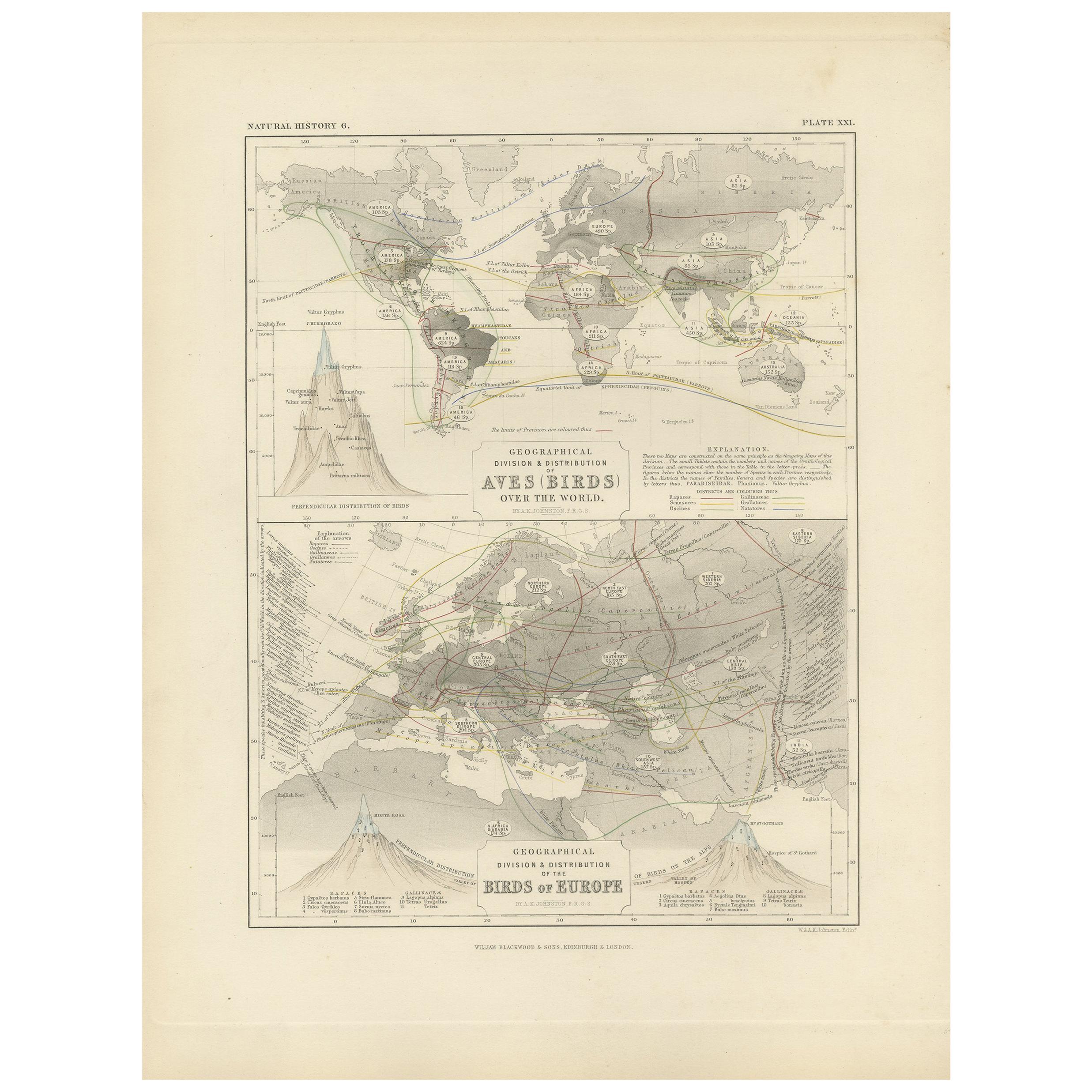
Antique Map Showing the Division and Distribution of Birds by Johnston '1850'
Located in Langweer, NL
Antique map titled 'Geographical division and distribution of birds over the world and birds of Europe'. Original antique map showing the geographical ...
Category
Antique Mid-19th Century Maps
Materials
Paper
$188 Sale Price
20% Off
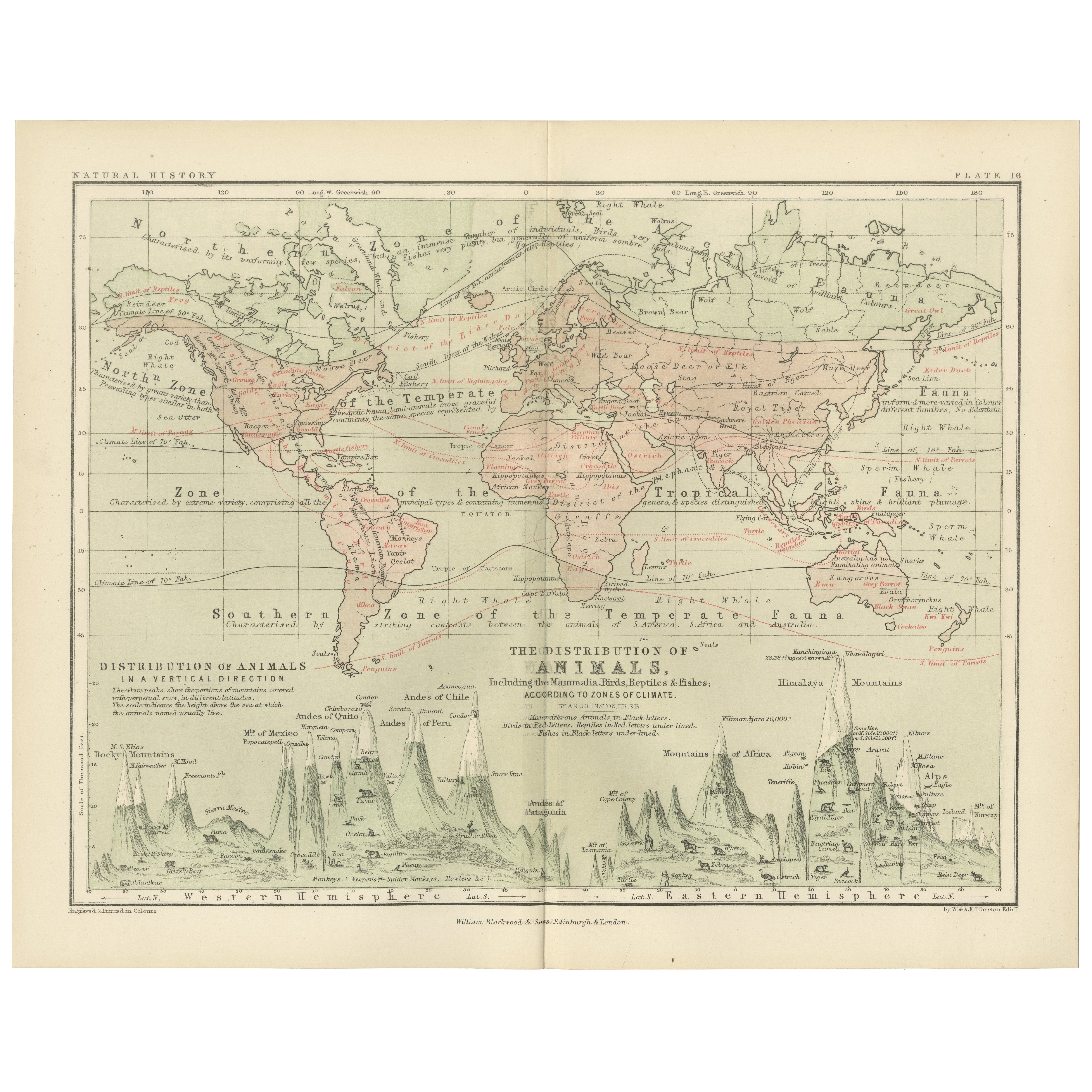
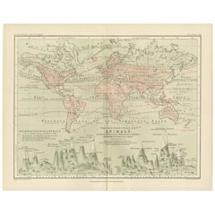
Animal Distribution Map by A.K. Johnston – Fauna by Climate Zones 1852
Located in Langweer, NL
Animal Distribution Map by A.K. Johnston – Fauna by Climate Zones 1852
This beautifully engraved chart titled "The Distribution of Animals Including the Mammalia, Birds, Reptiles & ...
Category
Antique Mid-19th Century Scottish Prints
Materials
Paper
You May Also Like
Map of the World - Original Etching - 1820
Located in Roma, IT
Map of the World is an Original Etching realized by an unknown artist of 19th century in 1820.
Very good condition on two sheets of white paper joine...
Category
1820s Modern Figurative Prints
Materials
Etching

Original Antique Map of The Western Hemisphere by Dower, circa 1835
Located in St Annes, Lancashire
Nice map of the Western Hemisphere
Drawn and engraved by J.Dower
Published by Orr & Smith. C.1835
Unframed.
Free shipping
Category
Antique 1830s English Maps
Materials
Paper

South America, Eastern Part. Century Atlas antique vintage map
Located in Melbourne, Victoria
'The Century Atlas. South America. Eastern Part'
Original antique map, 1903.
Inset map 'Rio de Janeiro and Vicinity'.
Central fold as issued. Map name and number printed on the rev...
Category
Early 20th Century Victorian More Prints
Materials
Lithograph

Old British Empire Map - Ancient Map by Karl Spruner - 1760 ca.
By Karl Spruner von Merz
Located in Roma, IT
Old British Empire Map is an artwork realized around 1760 by Karl Spruner.
Original hand-colored print.
Good conditions except for yellowing of pa...
Category
1760s Modern Figurative Prints
Materials
Etching

Original Antique Map of The World by Dower, circa 1835
Located in St Annes, Lancashire
Nice map of the World
Drawn and engraved by J.Dower
Published by Orr & Smith. C.1835
Unframed.
Free shipping
Category
Antique 1830s English Maps
Materials
Paper

Original Antique Map of The World by Thomas Clerk, 1817
Located in St Annes, Lancashire
Great map of The Eastern and Western Hemispheres
On 2 sheets
Copper-plate engraving
Drawn and engraved by Thomas Clerk, Edinburgh.
Published by Mackenzie And Dent, 1817
...
Category
Antique 1810s English Maps
Materials
Paper

More Ways To Browse
French Herbarium
French Kitchen Hutch
French Regency Bed
French Tea Trolley
Frog Wood Sculpture
George Iii Dressing Table
Georgian Style China Cabinet
Ginger Jar Blossom
Glass Music Box
Golden Closet
Greek Key Tray
Grotto Wall
Gun Storage
Gustavian Tall Cabinet
Half Round Window
Hand Carved Elephant Head
Haute Savoie Furniture
Haviland China