Items Similar to Fernando Alvarez de Toledo y Pimentel, Spanish Noble, General and Diplomat, 1750
Want more images or videos?
Request additional images or videos from the seller
1 of 6
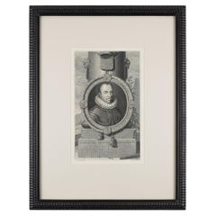
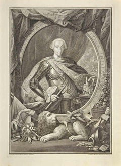
Fernando Alvarez de Toledo y Pimentel, Spanish Noble, General and Diplomat, 1750
$264.65
$330.8120% Off
£198.37
£247.9620% Off
€224
€28020% Off
CA$363.58
CA$454.4720% Off
A$405.90
A$507.3820% Off
CHF 212.69
CHF 265.8620% Off
MX$4,968.62
MX$6,210.7720% Off
NOK 2,701.11
NOK 3,376.3920% Off
SEK 2,546.80
SEK 3,183.5120% Off
DKK 1,705.17
DKK 2,131.4620% Off
Shipping
Retrieving quote...The 1stDibs Promise:
Authenticity Guarantee,
Money-Back Guarantee,
24-Hour Cancellation
About the Item
Antique portrait titled 'Ferdinandus Alvares van Toledo (..)'. Old portrait of Fernando Alvarez de Toledo y Pimentel or Ferdinandus Toletanus Dux Albanus (1507-1582). This print originates from 'Vaderlandsche historie, vervattende de geschiedenissen der nu Vereenigde Nederlanden, inzonderheid die van Holland (..)' by J. Wagenaar.
Artists and Engravers: Published by I. Tirion, Amsterdam.
Condition: Very good, please study image carefully.
Date: c.1750
Overall size: 13.5 x 23.5 cm.
Image size: 11 x 16.5 cm.
We sell original antique maps to collectors, historians, educators and interior decorators all over the world. Our collection includes a wide range of authentic antique maps from the 16th to the 20th centuries. Buying and collecting antique maps is a tradition that goes back hundreds of years. Antique maps have proved a richly rewarding investment over the past decade, thanks to a growing appreciation of their unique historical appeal. Today the decorative qualities of antique maps are widely recognized by interior designers who appreciate their beauty and design flexibility. Depending on the individual map, presentation, and context, a rare or antique map can be modern, traditional, abstract, figurative, serious or whimsical.
- Dimensions:Height: 9.26 in (23.5 cm)Width: 5.32 in (13.5 cm)Depth: 0 in (0.01 mm)
- Materials and Techniques:
- Period:
- Date of Manufacture:circa 1750
- Condition:Condition: Very good, please study image carefully.
- Seller Location:Langweer, NL
- Reference Number:Seller: BGI-003141stDibs: LU3054329259132
About the Seller
5.0
Recognized Seller
These prestigious sellers are industry leaders and represent the highest echelon for item quality and design.
Platinum Seller
Premium sellers with a 4.7+ rating and 24-hour response times
Established in 2009
1stDibs seller since 2017
2,511 sales on 1stDibs
Typical response time: <1 hour
- ShippingRetrieving quote...Shipping from: Langweer, Netherlands
- Return Policy
Authenticity Guarantee
In the unlikely event there’s an issue with an item’s authenticity, contact us within 1 year for a full refund. DetailsMoney-Back Guarantee
If your item is not as described, is damaged in transit, or does not arrive, contact us within 7 days for a full refund. Details24-Hour Cancellation
You have a 24-hour grace period in which to reconsider your purchase, with no questions asked.Vetted Professional Sellers
Our world-class sellers must adhere to strict standards for service and quality, maintaining the integrity of our listings.Price-Match Guarantee
If you find that a seller listed the same item for a lower price elsewhere, we’ll match it.Trusted Global Delivery
Our best-in-class carrier network provides specialized shipping options worldwide, including custom delivery.More From This Seller
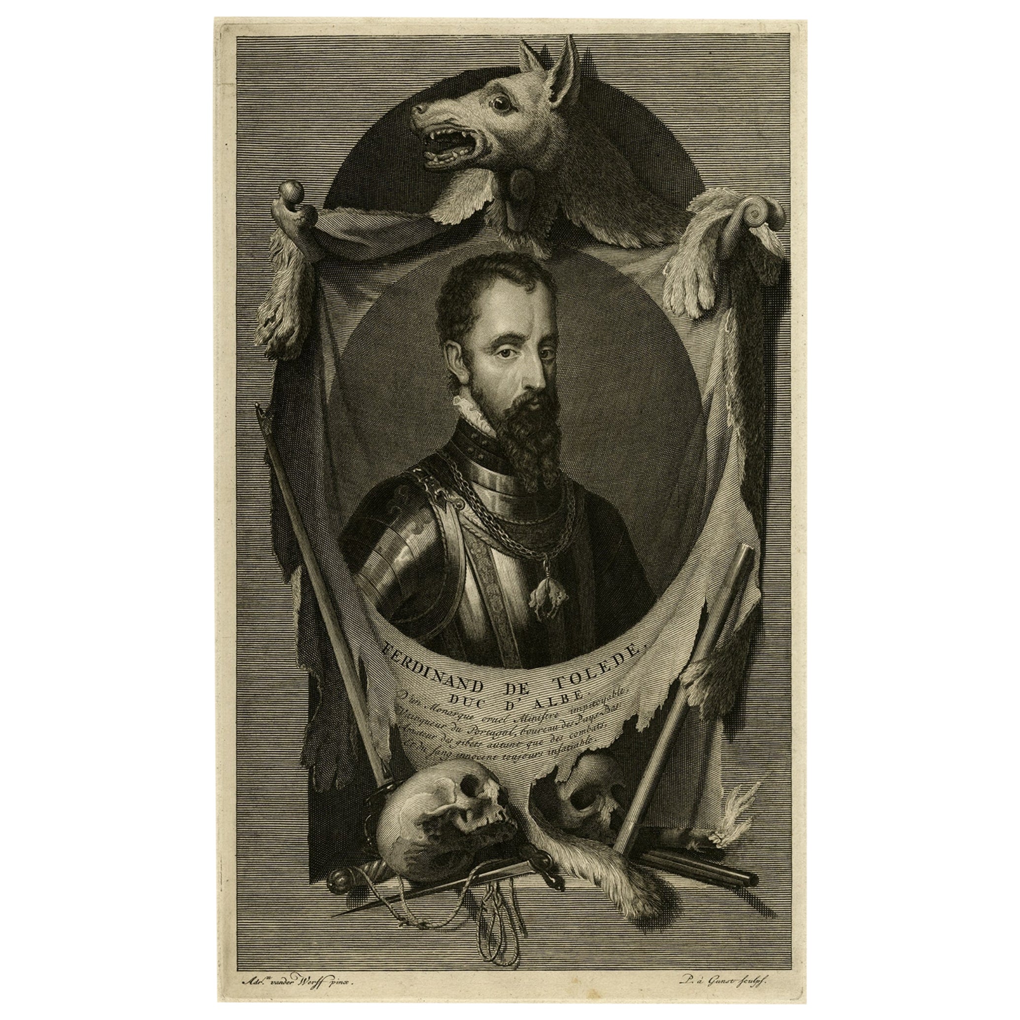
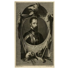
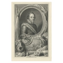
View AllPortrait of Fernando Alvarez de Toledo y Pimentel, Grand duke of Alba, c.1690
Located in Langweer, NL
Antique print, titled: 'Ferdinand de Tolede. Duc d'Albe.'
Portrait of Fernando Alvarez de Toledo y Pimentel, Grand duke of Alba (1507-1582). Source un...
Category
Antique 1690s Prints
Materials
Paper
$491 Sale Price
20% Off
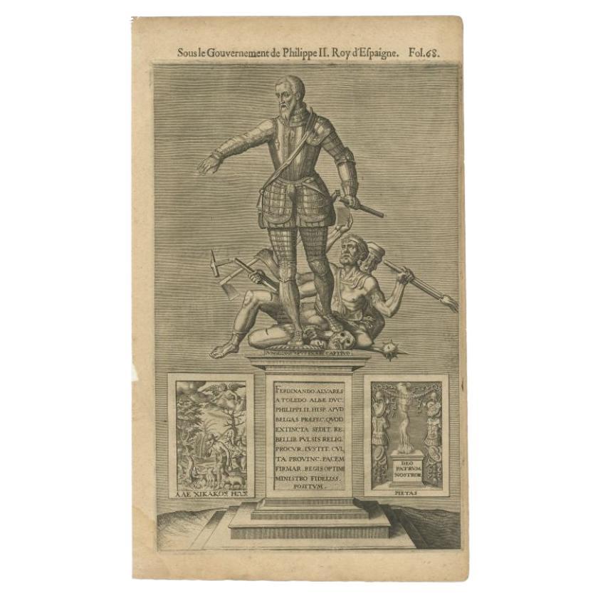
Antique Portrait of Fernando Alvarez De Toledo, the Grand Duke of Alba, 1618
Located in Langweer, NL
Antique portrait titled 'Ferdinando Alvares a Toledo (..)'. Old portrait of Fernando Alvarez de Toledo y Pimentel or Ferdinandus Toletanus Dux Albanus (1507 - 1582), known as the Grand Duke of Alba...
Category
Antique 17th Century Prints
Materials
Paper
$245 Sale Price
20% Off
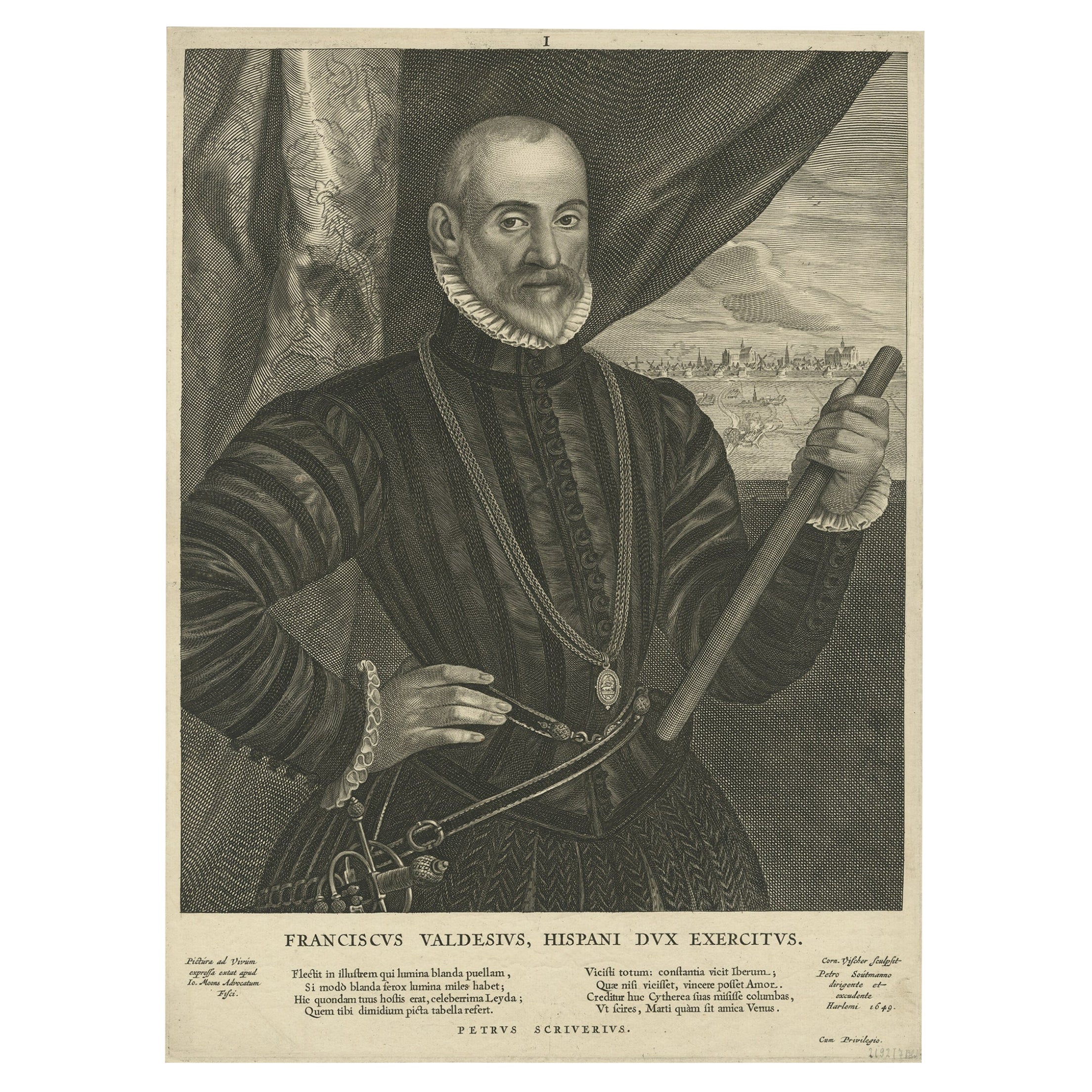
Very Rare Print of Franciscus Valdesius, Commander of the Spanish Troops, 1649
Located in Langweer, NL
Antique print, titled: 'Franciscus Valdesius, Hispani Dux exercitus' - Very rare half length portrait of Franciscus Valdesius ( Francis Valdez, Valdes or Baldes), printed in 1649. Fr...
Category
Antique 1640s Prints
Materials
Paper
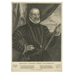
$793 Sale Price
20% Off
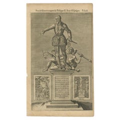
The Spanish Grand Duke of Alba or Iron Duke in the Netherlands, 1618
Located in Langweer, NL
Antique portrait titled 'Ferdinando Alvares a Toledo (..)'.
Old portrait of Fernando Alvarez de Toledo y Pimentel or Ferdinandus Toletanus Dux Albanus (1507 - 1582), known as the Grand Duke of Alba...
Category
Antique 1610s Prints
Materials
Paper
$245 Sale Price
20% Off
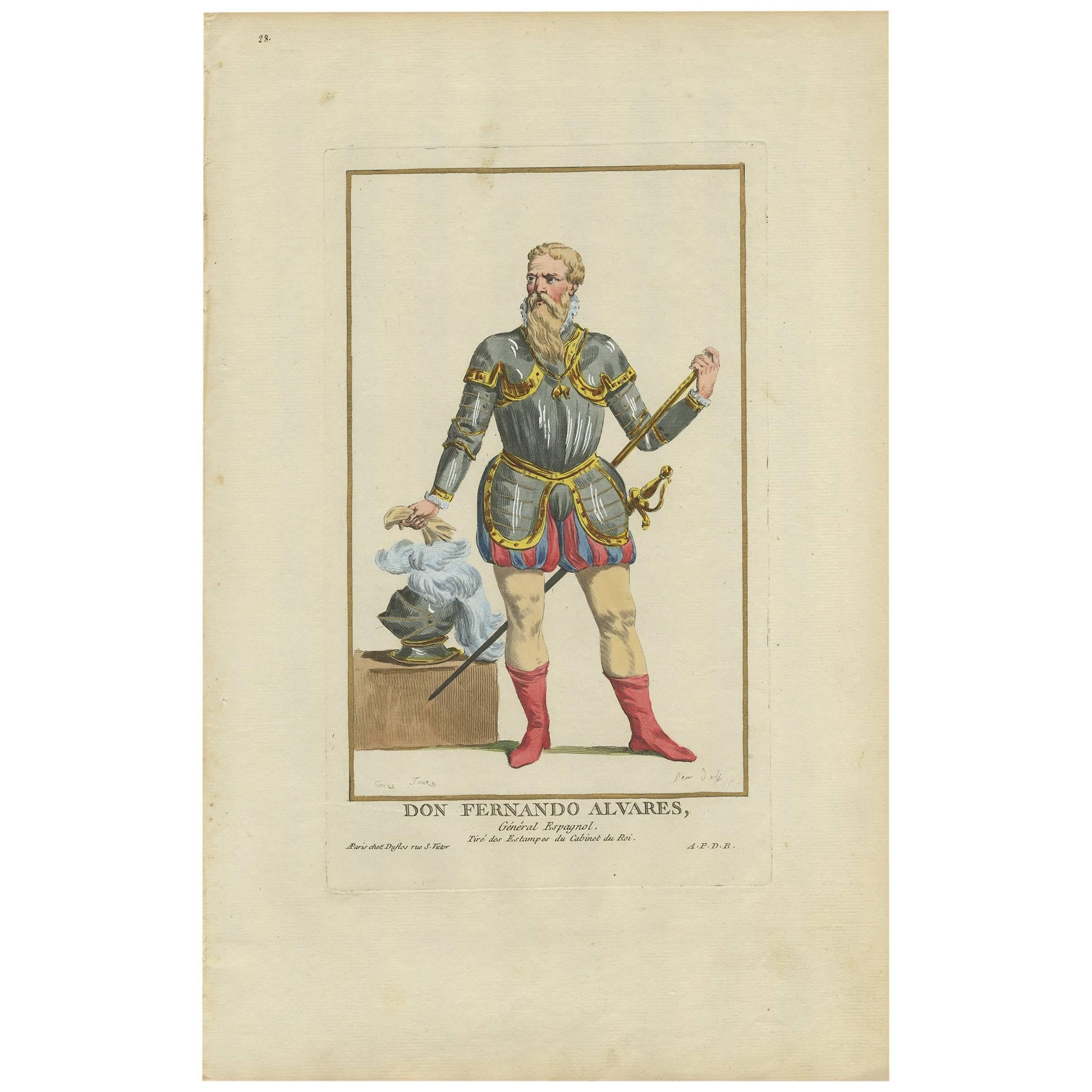
Antique Portrait of Fernando Alvarez by P. Duflos, 1787
Located in Langweer, NL
Antique print titled 'Don Fernando Alvares'. Fernando Álvarez de Toledo y Pimentel, 3rd Duke of Alba, GE, KOGF, GR (29 October 1507 – 11 December 1582), known as the Grand Duke of Alba in Spain and the Iron Duke in the Netherlands, was a Spanish noble...
Category
Antique Late 18th Century Prints
Materials
Paper

$283 Sale Price
20% Off
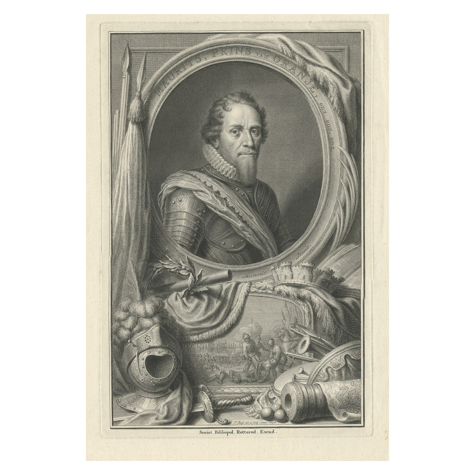
Original Antique Portrait of Maurice, The Prince of Orange, 1748
Located in Langweer, NL
Antique portrait titled 'Maurits, Prins van Oranje enz. enz. enz'. Engraving of Maurice, Prince of Orange. Bust length with beard, closed ruff, armour, and with sash over right shoul...
Category
Antique Mid-18th Century Dutch Prints
Materials
Paper
You May Also Like
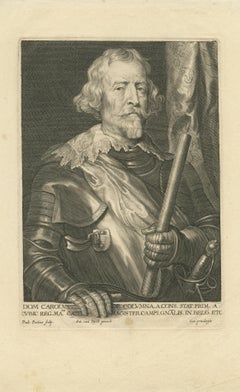
Portrait of Carlos de Colonna, Marques de la Espinar
By Paulus Pontius
Located in Middletown, NY
(after Anthonie Van Dyck) Engraving on cream laid paper, 9 1/4 x 6 3/8 inches (234 x 161 mm), full margins. Water stain throughout bottom, diagonal creases in the area of the bottom right corner, paper tape along top edge on recto. A very well inked impression.
__________Flemish painter and engraver Paulus Pontius was born in Antwerp in 1603, and it was in this city that his full life would unfold. At the young age of 13, he was apprenticed to the still life painter Osias Beert, and subsequently to Lucas Vosterman, who was heavily associated with the workshop of Peter Paul Rubens. Vosterman trained Pontius in the skill of engraving, which he took to immediately, finding he had great skill at recreating paintings. Pontius was able to capture the minutiae of light and shadow found on the canvas, and mastered the ability to accurately render the subtleties of brushwork in this alternate media. His success as an engraver cemented his role in the workshop of Rubens, and in 1624, when Vosterman found himself at odds with Rubens, and left Antwerp for England, Pontius assumed his role as foremost engraver in the workshop. It was in this year that Pontius took up lodgings in Rubens's home, and continued to live there until 1631, when courtship and marriage (the first of three) brought him away. After the death of Rubens in 1640, Pontius embarked on a very successful career engraving reproductions of master works by artists including Rubens, Anthony van Dyck, Jacob Jordaens, Pieter van Avont, Abraham van Diepenbeeck...
Category
Mid-17th Century Old Masters Portrait Prints
Materials
Laid Paper, Engraving
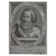
Antique Portrait of Philip of Hohenlohe-Neuenstein by Van Meteren, 1618
Located in Chonburi, TH
This antique portrait engraving of Philip of Hohenlohe-Neuenstein, created by the renowned engraver Emanuel van Meteren in 1618, is a remarkable piece of historical artwork. Van Mete...
Category
Antique Early 17th Century Dutch Prints
Materials
Paper
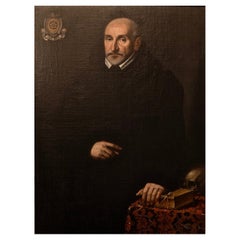
Portrait of Gentleman from Della Ruota Family, Lombardy, Dated 1624
Located in Bruxelles, BE
Portrait of a Gentleman from Della Ruota family
Lombardy, dated 1624
Oil on canvas
Measures: 105 x 81 cm (without the frame)
The coat of arms at the top left of the portrait identifies the effigy as an aristocrat belonging to the Lombard family Della Ruota, represented at the age of 61 in 1624.
The presence of vanity at the bottom right is a clear reference to the passage of time, to the aging and dying body...
Category
Antique 17th Century Italian Renaissance Paintings
Materials
Canvas
William I, Prince of Orange by Gerard Valck after van der Werff, 1680-1720
Located in Kenilworth, IL
Line engraving on laid paper of William I, Prince of Orange by Gerard Valck, after Adriaen van der Werff.
William I led the uprising which became known as the 80 Years War, which sou...
Category
Antique 18th Century English Prints
Materials
Paper
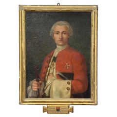
END OF THE 18th CENTURY PORTRAIT OF COUNT LUDOVICO CAPRARA
Located in Firenze, FI
Splendid oil portrait on canvas of Count Bailiff Ludovico Caprara (1731-1812), as indicated by the writing inside the "tabula ansata," at the bottom of the frame of the painting. The...
Category
Antique Late 18th Century Italian Paintings
Materials
Canvas, Wood, Paint
Charles III, King of Spain - Etching by Filippo Morghen - 18th Century
By Filippo Morghen
Located in Roma, IT
Charles III, King of Spain is an etching on paper realized by Filippo Morghen after Camillo Paderni in the 1760s.
Signed on the plate.
Good conditions ...
Category
18th Century Old Masters Figurative Prints
Materials
Etching
More Ways To Browse
American 4 Drawer Chest
Antique 6 Drawer Chest
Antique Camel Table
Antique Chest Federal
Antique Farm Cabinet
Antique French Bulldog
Antique Furniture Cheshire
Antique Kangaroo
Antique Mahogany 4 Drawer Chest
Antique Oak Bow Front Cabinet
Antique Pine China Cabinet
Antique Primitive Chest
Antique Rosewood Dresser
Antique Salvage Windows
Antique Seahorse
Antique Shell Bottles
Antique Silver New Orleans
Antique Spice Cabinet