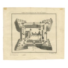
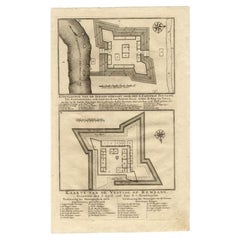
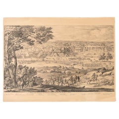
Items Similar to Fort Hollandois De Paliacate Nommé Le Fort De Gueldre, Bellin, 1751
Want more images or videos?
Request additional images or videos from the seller
1 of 5
Fort Hollandois De Paliacate Nommé Le Fort De Gueldre, Bellin, 1751
$115.02
$143.7820% Off
£85.63
£107.0320% Off
€96
€12020% Off
CA$157.55
CA$196.9420% Off
A$175.23
A$219.0420% Off
CHF 91.50
CHF 114.3820% Off
MX$2,132.38
MX$2,665.4720% Off
NOK 1,168.60
NOK 1,460.7520% Off
SEK 1,095.94
SEK 1,369.9220% Off
DKK 730.81
DKK 913.5220% Off
Shipping
Retrieving quote...The 1stDibs Promise:
Authenticity Guarantee,
Money-Back Guarantee,
24-Hour Cancellation
About the Item
Antique print, titled: ?Fort Hollandois de Paliacate nommé le Fort de Gueldre?. Published for Antonine de Prevost d' Exile's Histoire generale des voyages. Artists and Engravers: Jacques-Nicolas Bellin (1703 - 1772) was one of the most important cartographers of the 18th century. With a career spanning some 50 years, Bellin is best understood as geographe de cabinet and transitional mapmaker spanning the gap between 18th and early 19th century cartographic styles. His long career as Hydrographer and Ingénieur Hydrographe at the French Dépôt des cartes et plans de la Marine resulted in hundreds of high quality nautical charts of practically everywhere in the world. A true child of the Enlightenment Era, Bellin's work focuses on function and accuracy tending in the process to be less decorative than the earlier 17th and 18th century cartographic work. Unlike many of his contemporaries, Bellin was always careful to cite his references and his scholarly corpus consists of over 1400 articles on geography prepared for Diderot's Encyclopedie. Bellin, despite his extraordinary success, may not have enjoyed his work, which is described as ""long, unpleasant, and hard."" In addition to numerous maps and charts published during his lifetime, many of Bellin's maps were updated (or not) and published posthumously. He was succeeded as Ingénieur Hydrographe by his student, also a prolific and influential cartographer, Rigobert Bonne.
Artist: Jacques-Nicolas Bellin (1703 - 1772) was one of the most important cartographers of the 18th century. With a career spanning some 50 years, Bellin is best understood as geographe de cabinet and transitional mapmaker spanning the gap between 18th and early 19th century cartographic styles. His long career as Hydrographer and Ingénieur Hydrographe at the French Dépôt des cartes et plans de la Marine resulted in hundreds of high quality nautical charts of practically everywhere in the world. A true child of the Enlightenment Era, Bellin's work focuses on function and accuracy tending in the process to be less decorative than the earlier 17th and 18th century cartographic work. Unlike many of his contemporaries, Bellin was always careful to cite his references and his scholarly corpus consists of over 1400 articles on geography prepared for Diderot's Encyclopedie. Bellin, despite his extraordinary success, may not have enjoyed his work, which is described as ""long, unpleasant, and hard."" In addition to numerous maps and charts published during his lifetime, many of Bellin's maps were updated (or not) and published posthumously. He was succeeded as Ingénieur Hydrographe by his student, also a prolific and influential cartographer, Rigobert Bonne.
Condition: Good, given age. Original folds as issued. General age-related toning and/or occasional minor defects from handling. Please study scan carefully.
Date: 1751
Overall size: 19 x 25.7 cm
Image size: 0.001 x 14.2 x 19.5 cm
Antique prints have long been appreciated for both their aesthetic and investment value. They were the product of engraved, etched or lithographed plates. These plates were handmade out of wood or metal, which required an incredible level of skill, patience and craftsmanship. Whether you have a house with Victorian furniture or more contemporary decor an old engraving can enhance your living space. We offer a wide range of authentic antique prints for any budget.
- Dimensions:Height: 10.12 in (25.7 cm)Width: 7.49 in (19 cm)Depth: 0 in (0.01 mm)
- Materials and Techniques:
- Period:
- Date of Manufacture:1751
- Condition:
- Seller Location:Langweer, NL
- Reference Number:Seller: BL-000651stDibs: LU3054327107062
About the Seller
5.0
Recognized Seller
These prestigious sellers are industry leaders and represent the highest echelon for item quality and design.
Platinum Seller
Premium sellers with a 4.7+ rating and 24-hour response times
Established in 2009
1stDibs seller since 2017
2,510 sales on 1stDibs
Typical response time: <1 hour
- ShippingRetrieving quote...Shipping from: Langweer, Netherlands
- Return Policy
Authenticity Guarantee
In the unlikely event there’s an issue with an item’s authenticity, contact us within 1 year for a full refund. DetailsMoney-Back Guarantee
If your item is not as described, is damaged in transit, or does not arrive, contact us within 7 days for a full refund. Details24-Hour Cancellation
You have a 24-hour grace period in which to reconsider your purchase, with no questions asked.Vetted Professional Sellers
Our world-class sellers must adhere to strict standards for service and quality, maintaining the integrity of our listings.Price-Match Guarantee
If you find that a seller listed the same item for a lower price elsewhere, we’ll match it.Trusted Global Delivery
Our best-in-class carrier network provides specialized shipping options worldwide, including custom delivery.More From This Seller
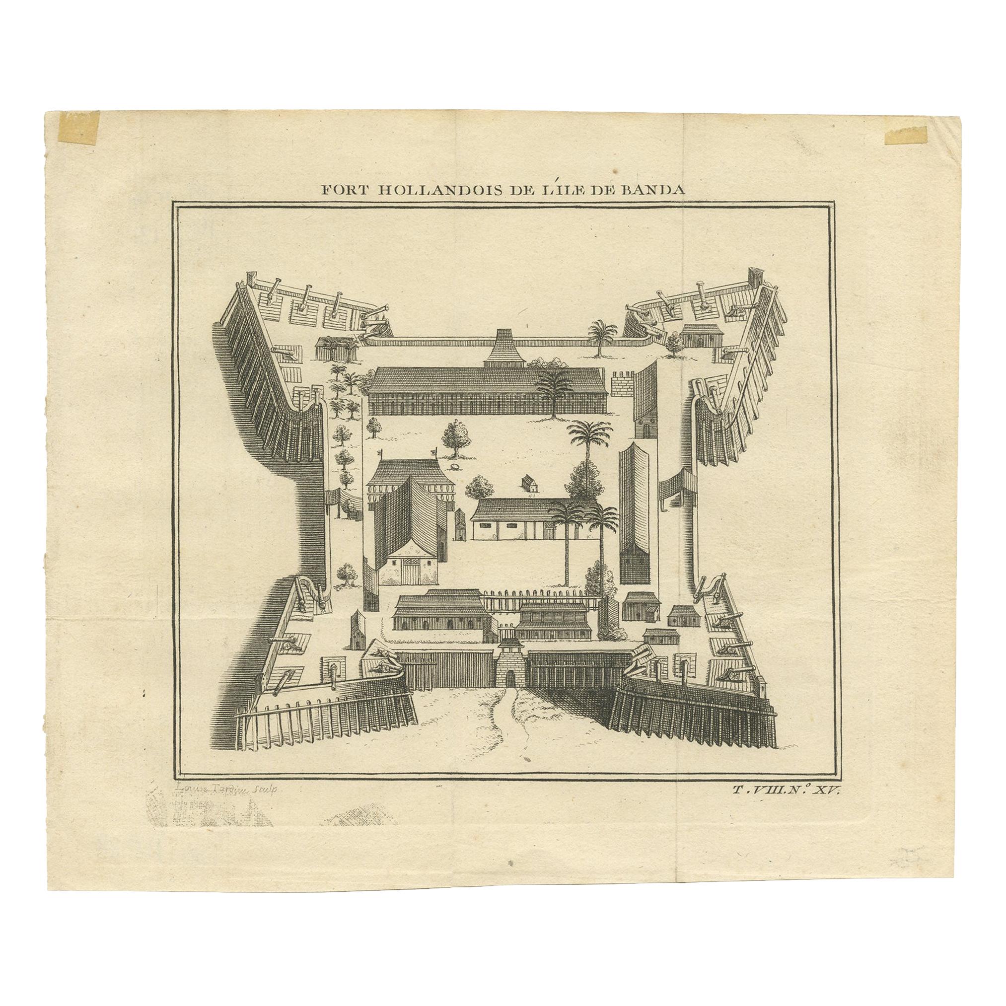
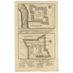
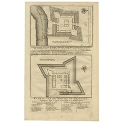
View AllAntique Print of the Dutch Fort on Banda by Tardieu 'circa 1750'
Located in Langweer, NL
Antique print titled 'Fort Hollandois de l'Ile de Banda'. Engraving of the Dutch VOC fortress Nassau, on Banda Neira, Indonesia. This print originates from '...
Category
Antique Mid-18th Century Prints
Materials
Paper
$115 Sale Price
20% Off
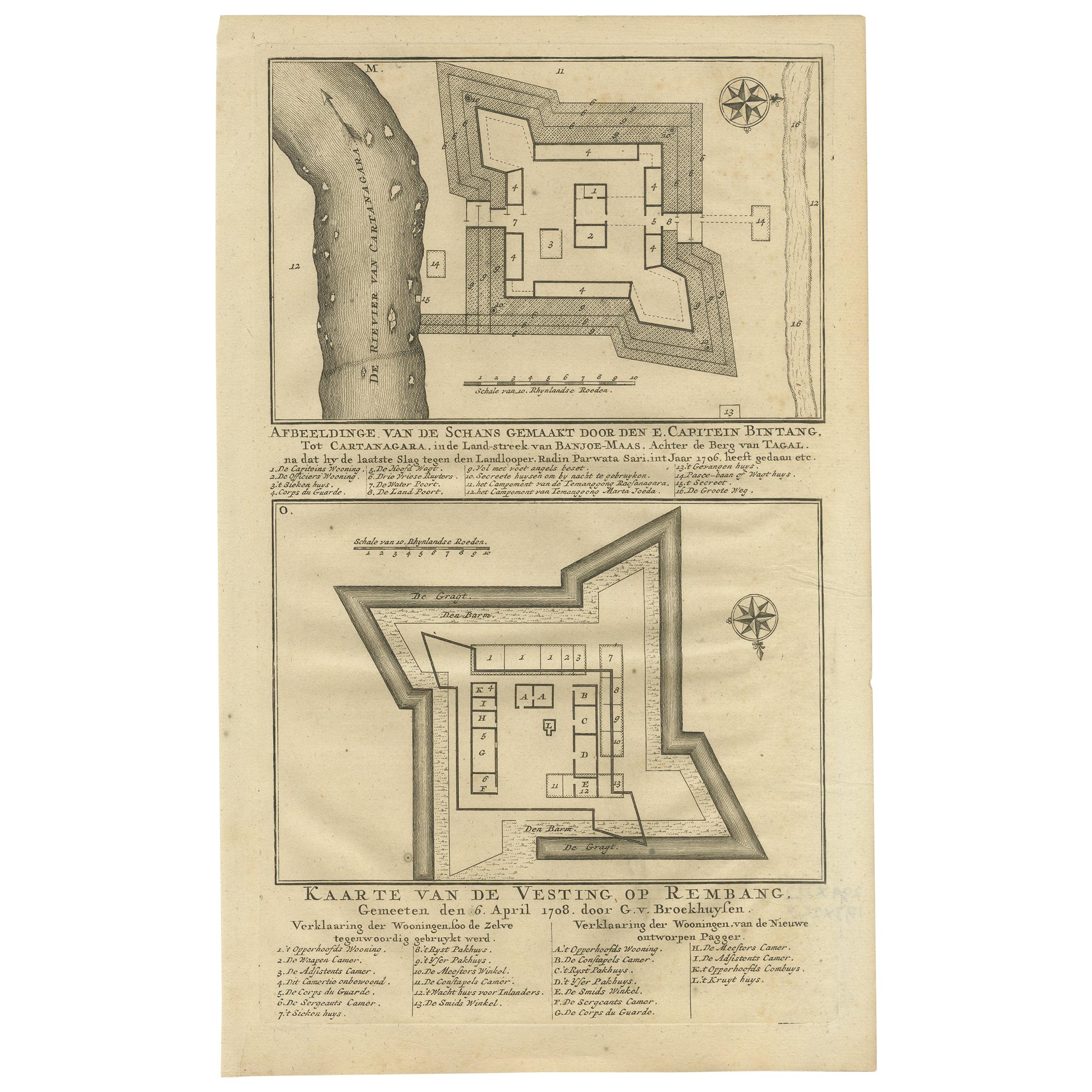
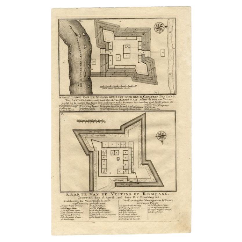
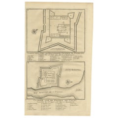
Antique Print of Fortresses in the Banyumas Region by Valentijn, 1726
By F. Valentijn
Located in Langweer, NL
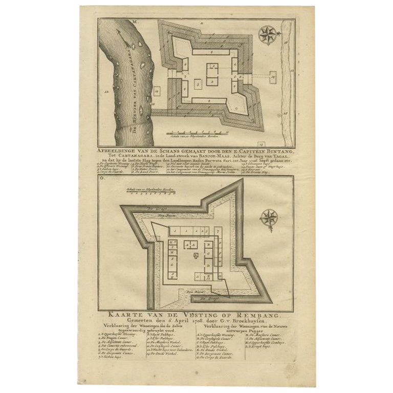
Antique print titled 'Kaarte van de Schans gemaakt door den E. Capitein Bintang. Kaarte van de Vesting op Rembang. ' A plan of the fort constructed by the Captain E. Bintang, in the ...
Category
Antique Mid-18th Century Prints
Materials
Paper
$115 Sale Price
20% Off
Antique Map of the Fortress of Captain E. Bintang by Valentijn, 1726
Located in Langweer, NL
Antique print titled 'Kaarte van de Schans gemaakt door den E. Capitein Bintang. Kaarte van de Vesting op Rembang.' A plan of the fort constructed by the Captain E. Bintang, in the B...
Category
Antique 18th Century Maps
Materials
Paper
$89 Sale Price
20% Off
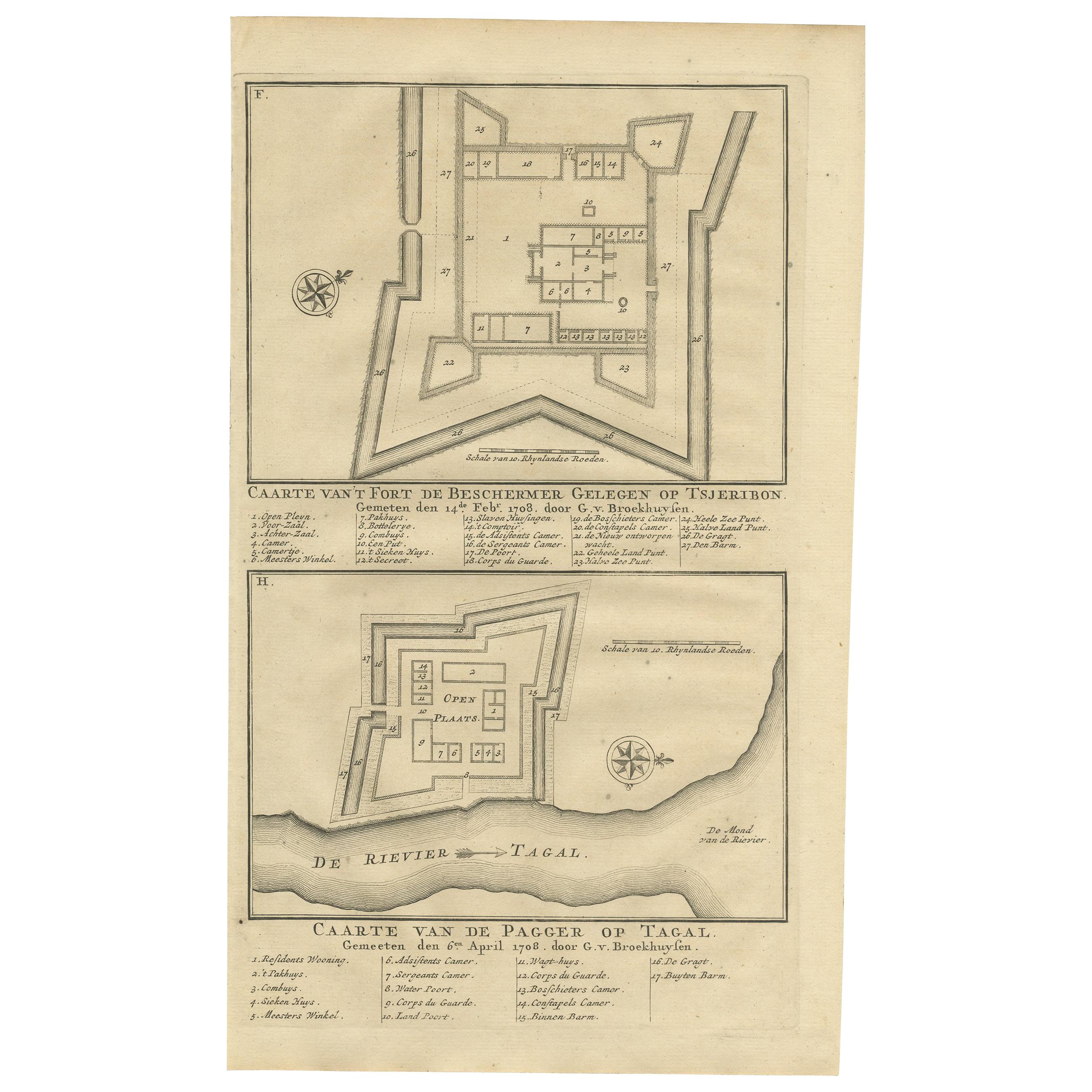
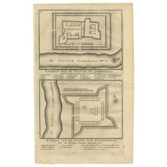
Antique Print of Fortresses in Indonesia by Valentijn '1726'
By F. Valentijn
Located in Langweer, NL
Antique print titled 'Caarte van het fort de Beschermer Gelegen op Tsjeribon. Caarte van de Pagger op Tagal'. A plan of the fortress 'de Beschermer' located on Cheribon (Java) and a ...
Category
Antique Early 18th Century Dutch Prints
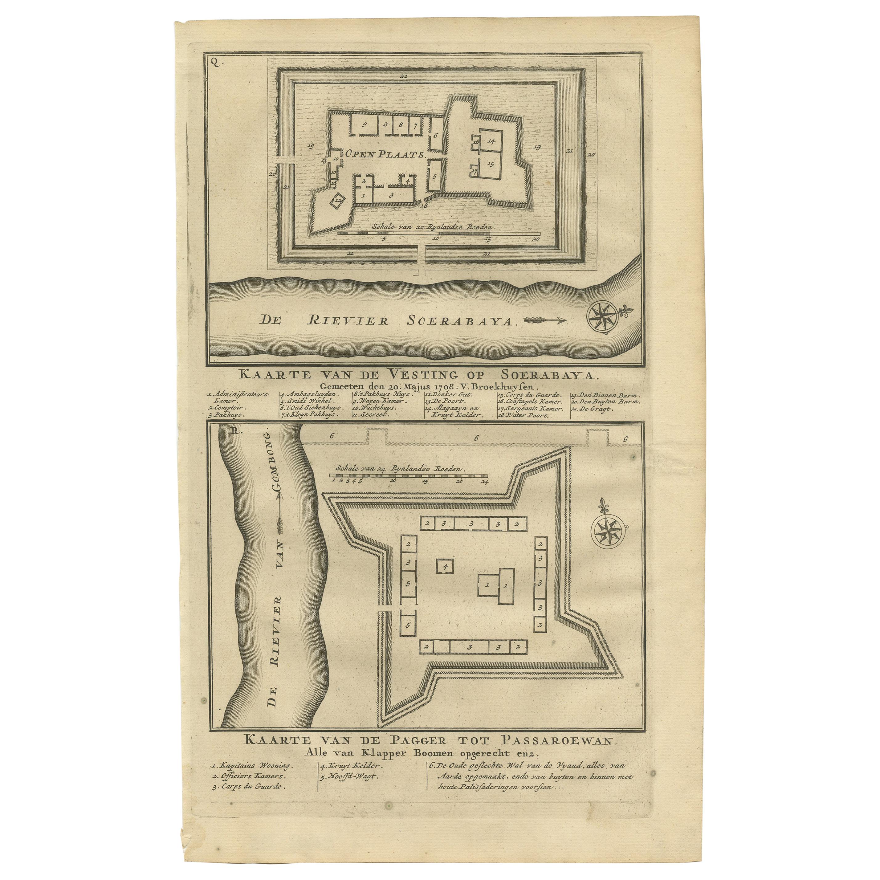
Antique Print of the Fortress on Surabaya and Pasuruan by Valentijn, 1726
Located in Langweer, NL
Antique print titled 'Kaarte van de vesting op Soerabaya. Kaarte van de Pagger tot Passaroewan. ' A plan of the fortress on Surabaya, and a plan of the fo...
Category
Antique Mid-18th Century Prints
Materials
Paper
$95 Sale Price
20% Off
Old Print of the Rembang Fortress of Captain E. Bintang on Java, Indonesia, 1726
Located in Langweer, NL
Antique print titled 'Kaarte van de Schans gemaakt door den E. Capitein Bintang. Kaarte van de Vesting op Rembang.' A plan of the fort constructed by the Captain E. Bintang, in the B...
Category
Antique 18th Century Prints
Materials
Paper
$220 Sale Price
20% Off
You May Also Like
17th-18th Century Siege of Graves Mapping Engraving By Willian III
Located in Kingston, NY
RARE French 17th-18th Century Enhanced Siege of Graves Mapping Engraving BY William III, also widely known as William of Orange,
The Siege of Grave in Dutch Brabant started by Monsie...
Category
Antique 17th Century French Prints
Materials
Paper

Ancient View of Chateau de Chronenbourg-Original Lithograph - Early 19th Century
Located in Roma, IT
Ancient View of Chateau de Chronenbourg is an original modern artwork realized in the first half of the 19th Century.
Original Lithograph on Ivory Paper.
Inscripted on the lower ...
Category
Early 19th Century Modern Figurative Prints
Materials
Lithograph

18th Century Map Engraving - Newport, a Strong Sea-Port Town in Flanders
Located in Corsham, GB
A map of Nieuwpoort, anglicised to 'Newport', in northern Belgium. There is a panorama in the upper quarter depicting major landmarks. Below is a plan of the town, including its strong defences and ships at the port in the lower register. Inscribed with the title in plate to the lower edge, 'Newport a Strong Sea-Port Town...
Category
18th Century More Prints
Materials
Engraving

$269 Sale Price
20% Off
Antique View of the Castle of Fontainbleau from the Garden
Located in Alessandria, Piemonte
View of the castle of FONTAINEBLEAU from the garden.
A rare engraving from the early nineteenth century.
ref. ST/777.
Category
Antique Early 19th Century French Other Prints
Materials
Paper
Lithograph View on Nieuw Amsterdam J . Vingboons 1660s
Located in Den Haag, NL
Afther a gouache by J Vingboons 1660s Beautiful Lithograph from 1910/20
Nieuw Amsterdam ofte nue nieuw Lorx opt Teyland Man .
Very nice fresh colors . Comes with a old label on the...
Category
Antique 1650s Dutch American Colonial Prints
Materials
Paper
Jacques Rigaud Engraving Palais Des Thuilleries
Located in Los Angeles, CA
French 18th Century Jacques Rigaud engraving of Palais Des Thuilleries. The dimension is the sight of the image. This item is ready to be framed to your...
Category
Antique 18th Century French Other Prints
Materials
Paper
More Ways To Browse
Map Cabinet
Antique Map Cabinet
Antique Straight Pins
Antique Wooden Drum
Art Deco Scarves
Bleached Walnut Chest
Brass Dolphin Table
Bronze Goddess Clock
Bronze Sculpture Bird Flight
Brutalist Starburst
Bull Head Sculpture
Burl Wood Secretary
Carriage Seat
Cassone Chest
Ceramic Spaniel
Charles Forge
Chicken Wire
Chinese Garden Rock