Items Similar to Antique Map of the Fortress of Captain E. Bintang by Valentijn, 1726


Want more images or videos?
Request additional images or videos from the seller
1 of 5
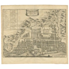
Antique Map of the Fortress of Captain E. Bintang by Valentijn, 1726
About the Item
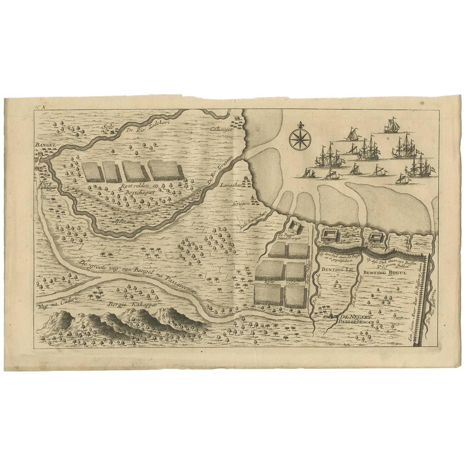
Antique print titled 'Kaarte van de Schans gemaakt door den E. Capitein Bintang. Kaarte van de Vesting op Rembang.' A plan of the fort constructed by the Captain E. Bintang, in the Banyumas region of Java, Indonesia. A second plan of the Fortress of Rembang. This print originates from 'Oud en Nieuw Oost-Indiën' by F. Valentijn.
Artists and Engravers: François Valentijn (1666-1727), a missionary, worked at Amboina from 1684 to 1694 and 1705 to 1713 and travelled extensively in the VOC's lands.
Condition: Good, given age. Three tiny holes, closed using contemporary paper backed with acid free archival tape. General age-related toning and/or occasional minor defects from handling. Please study image carefully.
Date: 1726
Overall size: 20.5 x 33.6 cm.
Image size: 18 x 30.4 cm.
We sell original antique maps to collectors, historians, educators and interior decorators all over the world. Our collection includes a wide range of authentic antique maps from the 16th to the 20th centuries. Buying and collecting antique maps is a tradition that goes back hundreds of years. Antique maps have proved a richly rewarding investment over the past decade, thanks to a growing appreciation of their unique historical appeal. Today the decorative qualities of antique maps are widely recognized by interior designers who appreciate their beauty and design flexibility. Depending on the individual map, presentation, and context, a rare or antique map can be modern, traditional, abstract, figurative, serious or whimsical. We offer a wide range of authentic antique maps for any budget
- Dimensions:Height: 13.23 in (33.6 cm)Width: 8.08 in (20.5 cm)Depth: 0 in (0.01 mm)
- Materials and Techniques:
- Period:
- Date of Manufacture:1726
- Condition:
- Seller Location:Langweer, NL
- Reference Number:
About the Seller
5.0
Platinum Seller
These expertly vetted sellers are 1stDibs' most experienced sellers and are rated highest by our customers.
Established in 2009
1stDibs seller since 2017
1,938 sales on 1stDibs
Typical response time: <1 hour
- ShippingRetrieving quote...Ships From: Langweer, Netherlands
- Return PolicyA return for this item may be initiated within 14 days of delivery.
More From This SellerView All
- Antique Map of the City of Ambon by Valentijn, 1726By F. ValentijnLocated in Langweer, NLAntique map titled 'De Platte Grond van Amboina zoo als het was in den Jaare, 1718'. Antique map depicting the City of Ambon, Indonesia. This print originates from 'Oud en Nieuw Oost...Category
Antique Early 18th Century Dutch Maps
MaterialsPaper
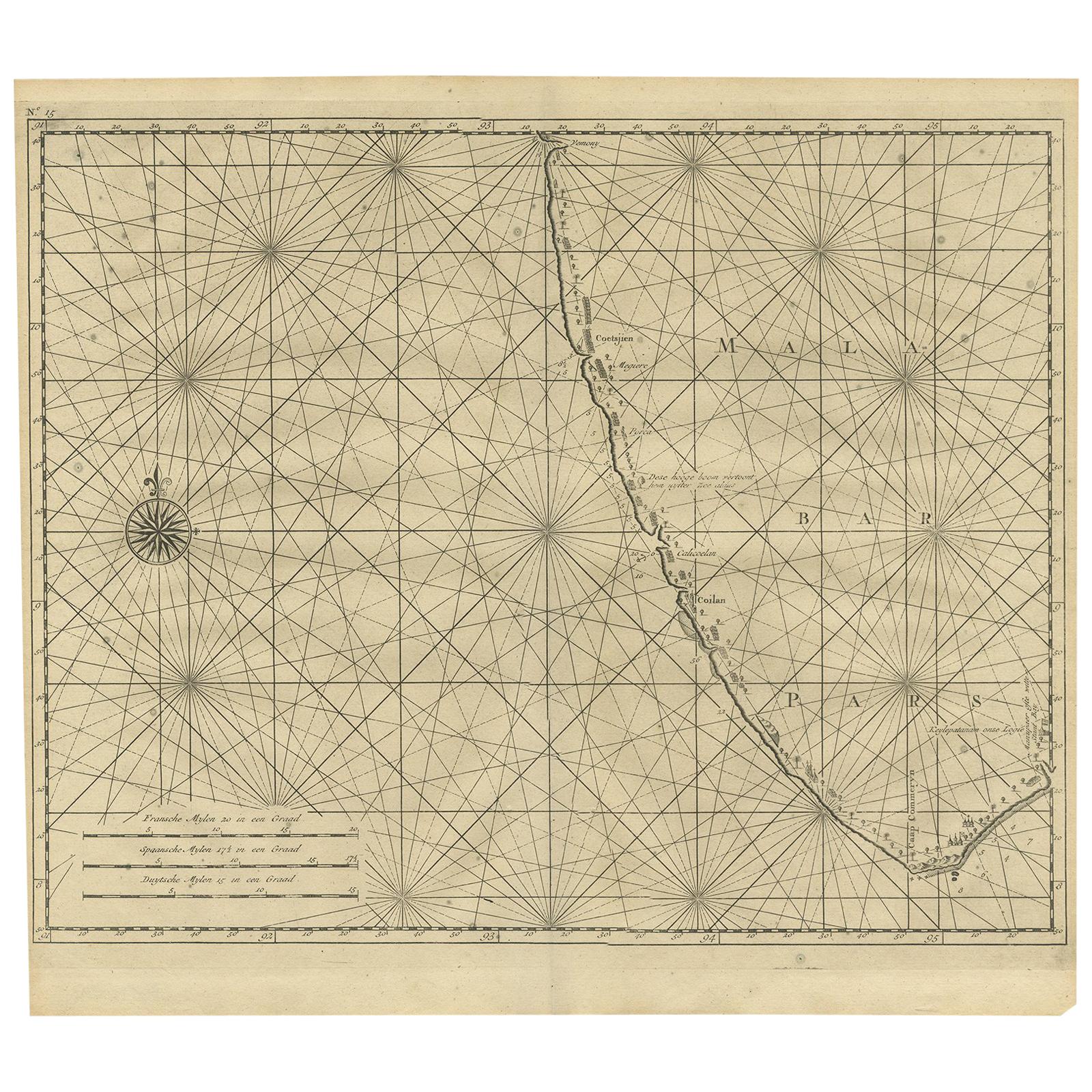
- Antique Map of Malabar Coast by Valentijn, 1726By F. ValentijnLocated in Langweer, NLUntitled sea chart of the coast of Malabar, India. This print originates from 'Oud en Nieuw Oost-Indiën' by F. Valentijn.Category
Antique Early 18th Century Dutch Maps
MaterialsPaper
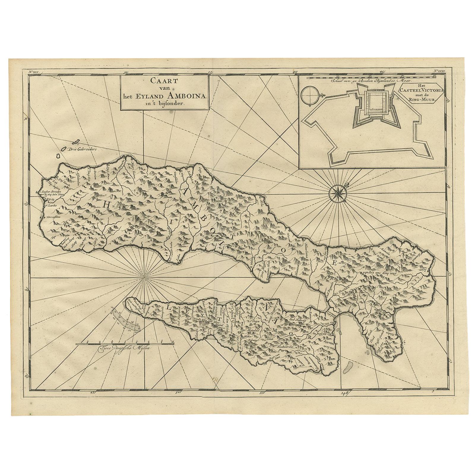
- Antique Map of Ambon Island by Valentijn, 1726By F. ValentijnLocated in Langweer, NLAntique map titled 'Caart van het Eyland Amboina in 't bijsonder'. Map of the Islands Ambon and Timor, one of the Moluccan Islands, Indonesia, with an inset of castle Victoria with t...Category
Antique Early 18th Century Dutch Maps
MaterialsPaper
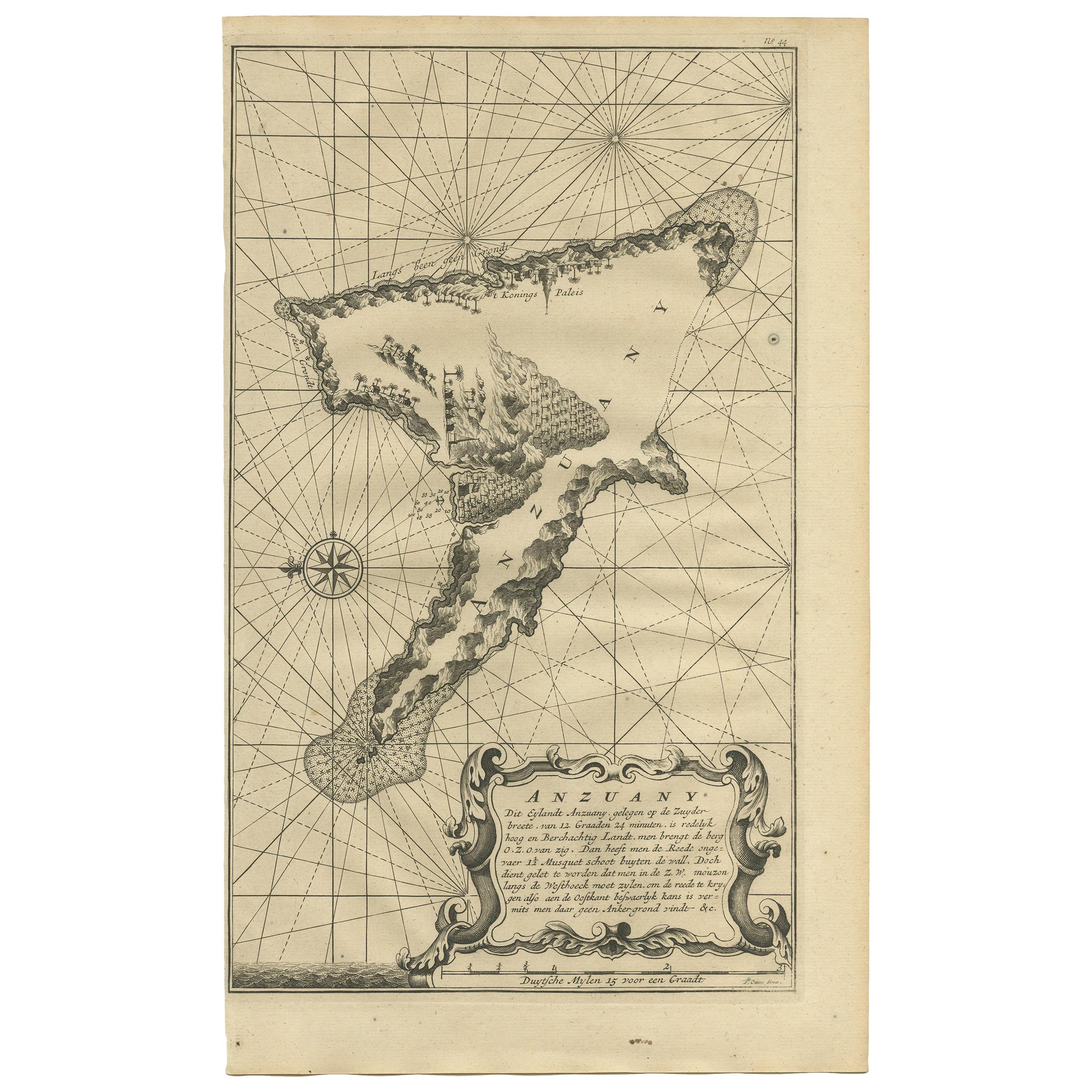
- Antique Map of Anjouan Island by Valentijn, 1726By F. ValentijnLocated in Langweer, NLAntique map titled 'Anzuany'. This map depicts the island of Anjouan, one of the Comoros islands situated between Madagascar and Africa. The map is oriented with north to the left wi...Category
Antique Early 18th Century Dutch Maps
- Antique Map of the Expedition of Govert Knol by Valentijn, 1726Located in Langweer, NLAntique map titled 'Aftekening der Expeditie van de Hr. Commissaris Govert Cnoll uyt Soerabaja, tot afhalinge van Pangerang Adepati Anom'. Map showing the expedition...Category
Antique 18th Century Maps
MaterialsPaper
- Antique Map of the Banda Islands in Indonesia by Valentijn, 1726Located in Langweer, NLAntique map Indonesia titled 'Kaart der Zuyd-Wester Eylanden van Banda'. Map of the islands in the southwestern part of the Banda Sea including ...Category
Antique Mid-18th Century Maps
MaterialsPaper


You May Also Like
- 1861 Topographical Map of the District of Columbia, by Boschke, Antique MapLocated in Colorado Springs, COPresented is an original map of Albert Boschke's extremely sought-after "Topographical Map of the District of Columbia Surveyed in the Years 1856 ...Category
Antique 1860s American Historical Memorabilia
MaterialsPaper
- Captain Cook's Exploration of Tahiti 18th C. Hand-Colored Map by BellinBy Jacques-Nicolas BellinLocated in Alamo, CAThis beautiful 18th century hand-colored copper plate engraved map is entitled "Carte de l'Isle de Taiti, par le Lieutenant J. Cook" was created by Jacques Nicolas Bellin and publish...Category
Antique Mid-18th Century French Maps
MaterialsPaper
- 1929 The Novels of Captain MarryatBy Frederick MarryatLocated in Bath, GBA superb set of the novels of Captain Marryat, elegantly and uniformly bound in half morocco, and illustrated throughout. A twenty-two volume set in half morocco bindings, with pictorial gilt to the spines. All edges gilt. Captain Frederick Marryat (1792-1848) was a Royal Navy officer and an early pioneer of nautical fiction. He is best known for his semi-autobiographical novel Mr Midshipman Easy (1836) and for his children's novel The Children of the New Forest (1847). He also developed Marryat's Code, a widely used system of maritime flag signalling. This handsome set includes twenty-two of Marryat's novels, edited with a prefatory note to each volume by R. Brimley Johnson. The set is lacking Volumes VII and X. These volumes have been reprinted from the first editions. Volume I contains a brief biography of Marryat by the editor. This set comprises: Volume I: Peter Simple Volume II: Frank Mildmay Volume III: Newton Forster Volume IV: Jacob Faithful Volume V: The Pacha of Many Tales Volume VI: Mr Midshipman Easy Volume VIII: Snarleyyow Volume IX: The Phantom Ship Volume XI: Poor Jack Volume XII: The King's Own Volume XIII: Joseph Rushbrook Volume XIV: Percival Keene Volume XV: Monsieur Violet Volume XVI: The Privateer's Man Volume XVII: Masterman Ready Volume XVIII: The Settlers in Canada Volume XIX: The Mission Volume XX: The Children of the New Forest Volume XXI: The Little Savage Volume XXII: Valerie Including two unnumbered, yet uniformly bound, volumes: Japhet, in Search of a Father and Olla Podrida. All volumes are illustrated with engraved frontispieces, and a further two engraved plates, by artists such as D. Downing, D. Murray-Smith, Charles O. Murray, J. Aytoun Symington and W. G. Tennick. The frontispiece to Volume XV is a folding map; this volume also contains a duplicated plate. Collated, complete. Undated, dated through copies held at Trinity College Dublin Library...Category
Vintage 1920s British Books
MaterialsPaper
- 1907 Map of Colorado, Antique Topographical Map, by Louis NellLocated in Colorado Springs, COThis highly detailed pocket map is a topographical map of the state of Colorado by Louis Nell from 1907. The map "has been complied from all availabl...Category
Antique Early 1900s American Maps
MaterialsPaper
- Original Antique Map of The Netherlands, Engraved by Barlow, Dated 1807Located in St Annes, LancashireGreat map of Netherlands Copper-plate engraving by Barlow Published by Brightly & Kinnersly, Bungay, Suffolk. Dated 1807 Unframed.Category
Antique Early 1800s English Maps
MaterialsPaper
- Original Antique Map of the American State of Nevada, 1889Located in St Annes, LancashireGreat map of Nevada Drawn and Engraved by W. & A.K. Johnston Published By A & C Black, Edinburgh. Original colour Unframed.Category
Antique 1880s Scottish Victorian Maps
MaterialsPaper


Recently Viewed
View AllMore Ways To Browse
Antique E
Captain Antique
Antique Vest
Java Map
Fortress Antiques
Java Door
Antique Russian Wood Furniture
Antique Russian Wood
Compass Antique Map
Antique Compass Map
Large Antique Map Of The World
Antique Britain Map
Antique China Map
Antique Map Britain
Antique Map China
Antique Chinese Maps
Premier Antiques
Antique Map Of China