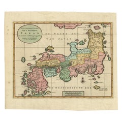
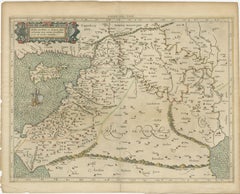
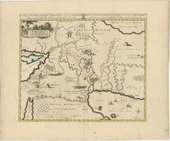
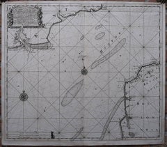
Antique Map of Japan with Scale and Compass Rose, c.1730
Located in Langweer, NL
Japan. With scale and compass rose. This map originates from 'Hedendaegsche historie, of tegenwoordige
Category
18th Century Antique Compass Map
Materials
Paper
Antique Map of Japan with Scale and Compass Rose, c.1730
Located in Langweer, NL
Japan. With scale and compass rose. This map originates from 'Hedendaegsche historie, of tegenwoordige
Paper
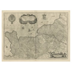
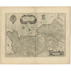
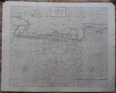
Antique Map of Normandy by Janssonius, 1657
Located in Langweer, NL
decorative cartouche, sailing ships and compass rose. This map originates from 'Atlas Novus, Sive Theatrum
Paper
$5,588
H 19.69 in W 23.23 in D 0.01 in
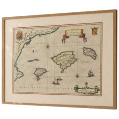
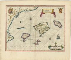
Antique Blaeu Map Mallorca Ibiza Balearic Islands, Mediterranean, 1642
Located in Langweer, NL
, nautical map ships compass rose, decorative island map, luxury coastal wall art, Mediterranean decor art
Paper
$545Sale Price|20% Off
H 15.95 in W 20.01 in D 0.02 in
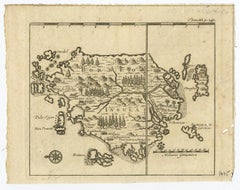
Mercator's Ptolemaic map of Taprobana, (Ceylon) Sri Lanka
Located in Langweer, NL
Antique map titled 'Asiae XII Tab'. Mercator's Ptolemaic map of Taprobana. The map shows Ptolemy's
Paper
$320Sale Price|20% Off
H 6.86 in W 8.67 in D 0.02 in
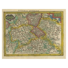
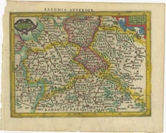
Small Original Antique Map of Upper Saxony, Germany
Located in Langweer, NL
constant compass bearing on a flat map.
Paper
$282
H 8.75 in W 11.23 in D 0.01 in
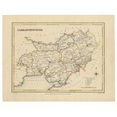
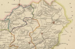
Map of Carmarthenshire 1844 – Carmarthen Llandeilo Llanelli Laugharne Llandovery
Located in Langweer, NL
original hand coloring outlines the administrative divisions. The map includes a compass rose and a
Paper
$258
H 7.6 in W 9.38 in D 0.01 in
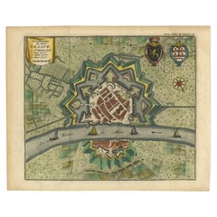
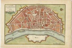
Antique Plan of the City of Grave, Holland - Coats of Arms & Compass Rose, 1750
By Isaak Tirion
Located in Langweer, NL
Antique map titled 'Grondtekening der Stad Graave'. Plan of Grave, The Netherlands. With coats of
Paper

$272Sale Price|20% Off
H 8.9 in W 12.09 in D 0.02 in
Original Antique Map of England, Ireland, Scotland and Wales
Located in Langweer, NL
political and administrative divisions, landmarks and place names. Includes index and compass rose. This map
Paper

$705Sale Price|20% Off
H 8.08 in W 12.8 in D 0.02 in
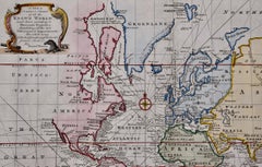
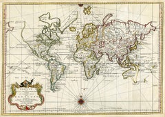
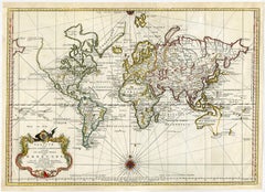
Antique Map of the World on Mercator's Projection, 1788
Located in Langweer, NL
Antique map titled 'Kaart van de Geheele Wereld (..)'. Uncommon small world map on Mercator's
Paper
$527Sale Price|20% Off
H 10.63 in W 8.08 in D 0 in
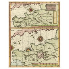
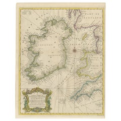
Two Charts of The English Channel, Each Adorned with Nice Compass Roses, ca.1700
Located in Langweer, NL
Antique map titled 'Hydrographia Canalis Marini Inter Angliam et Galiiam de Fluentis.' Sheet
Paper
$5,764
H 19.69 in W 23.23 in D 0.01 in
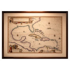
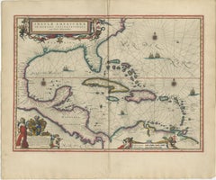
Important Blaeu Caribbean Map, West Indies, Decorative Atlas Chart, c.1642
Located in Langweer, NL
, maritime navigation map, rhumb lines map, compass rose map, decorative cartouche map, atlas Blaeu, Blaeu
Paper

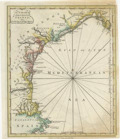
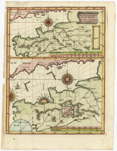
Antique Map of the Coast of Southern France, 1793
Located in Langweer, NL
. **Navigational Aids**: - The map features a compass rose with radiating lines, a common navigational aid in
Paper
$517
H 10.36 in W 9.45 in D 0.01 in
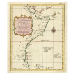
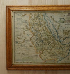
East African Coast – French Map by Bellin, Zanzibar to Arabia, 1740
Located in Langweer, NL
, a longitudinal grid, and a finely engraved compass rose reinforce the map’s scientific and
Paper
$320Sale Price|20% Off
H 6.86 in W 8.67 in D 0.02 in
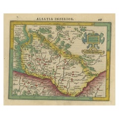
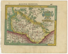
Small Original Antique Map of the Lower Alsace region, Germany
Located in Langweer, NL
Projection, a system which allowed navigators to plot the same constant compass bearing on a flat map.
Paper
$602Sale Price|20% Off
H 13 in W 16.07 in D 0 in
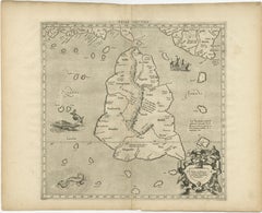
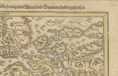
Sebastian Münster's 16th Century Map of the British Isles, ca.1590
Located in Langweer, NL
was formerly called Albion and Britannia." - The map has compass directions labeled as "OCCIDENS
Paper
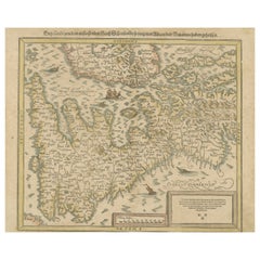
Antique Map of the Region of Amsterdam by Wagenaar, c.1760
Located in Langweer, NL
Netherlands around 1750. With compass rose and scale. This map originates from: 'Amsterdam, In Zyne Opkomst
Paper
$894Sale Price|20% Off
H 16.15 in W 20.87 in D 0.01 in
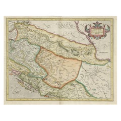
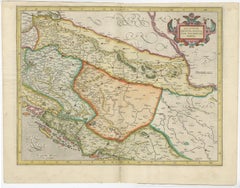
Old Eastern Balkans Map, with Dalmatia, Croatia, Slavonia, Bosnia, Serbia, 1633
Located in Langweer, NL
to plot the same constant compass bearing on a flat map. Condition: Good, German text on verso
Paper
$649Sale Price|20% Off
H 15.63 in W 19.77 in D 0.02 in
Mercator's Ptolemaic Map of the Holy Land, Cyprus and Syria, circa 1580
Located in Langweer, NL
Projection, a system which allowed navigators to plot the same constant compass bearing on a flat map.
Paper


Antique Map of the Coast of Juan Fernandez by Van Schley, 1757
Located in Langweer, NL
tip of South America. This map is topped by a view of the Cumberland Bay with its own compass rose
Paper
$1,082Sale Price|20% Off
H 16.15 in W 21.26 in D 0 in
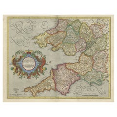
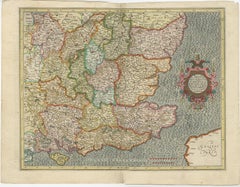
Original Antique Map of the English counties Cornwall, Devon, Dorset, etc, 1633
Located in Langweer, NL
Antique map titled 'Cornubia, Devonia, Somersetus, Dorcestria, Wiltonia, Glocestria, Monumetha
Paper

$1,281
H 17.52 in W 21.07 in D 0.79 in
London 1744 Published Watercolour Antique Map of East Africa by Eman Bowen
Located in West Sussex, Pulborough
is highly embellished, including a cartouche showing a wildebeest and a compass rose. The map extends
Paper
$602Sale Price|20% Off
H 16.93 in W 22.05 in D 0.02 in
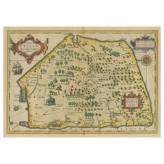
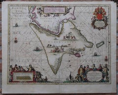
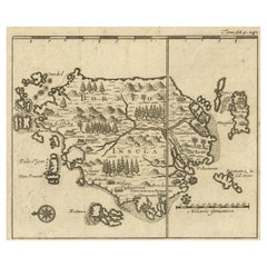
Antique Map of Sri Lanka with an unusual five-sided shape, circa 1606
Located in Langweer, NL
Antique map titled 'Ins. Ceilan quae incolis Tenarisin dicitur'. This exquisite, early map of Sri
Paper

$1,875
H 20.5 in W 23.5 in D 0.13 in
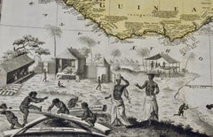
West Africa Entitled "Guinea Propria": An 18th Century Hand Colored Homann Map
By Johann Baptist Homann
Located in Alamo, CA
play around inscribed ivory tusks. One of the children holds a compass tool. This striking map of
Paper
$1,191Sale Price|25% Off
H 15.75 in W 18.51 in D 0.01 in
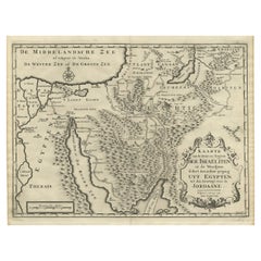
Scarce Middle East and Arabia Map Showing The Exodus of the Israelites, 1725
Located in Langweer, NL
, compass rose and scale. This map originates from 'Het algemeen groot historisch, oordeelkundig
Paper
$676
H 13.98 in W 15.75 in D 0 in
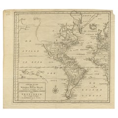
Excellent Antique Map of America with Unusual Northwest Coast of America, c.1754
Located in Langweer, NL
the Eastern Seaboard. Overall a very attractive map, with a compass rose. Source unknown, to be
Paper


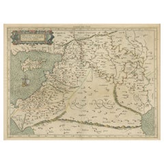
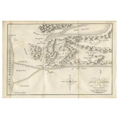
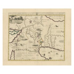
Antique Map of The Nile, Egypt and the Red Sea by Bachiene, 1765
Located in Langweer, NL
of Biblical Egypt and the Red Sea. With title cartouche, compass rose and scale. This map originates
Paper
$541
H 7.88 in W 11.74 in D 0.01 in
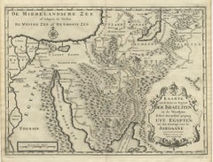
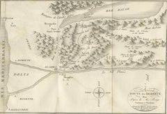
Antique Map of the Route of the Hebrews – Egypt to the Red Sea, 1720
Located in Langweer, NL
Map of the Route of the Hebrews – Egypt to the Red Sea, 1720 This finely engraved 18th-century map
Paper
$1,082Sale Price / item|20% Off
H 16.15 in W 21.26 in D 0 in
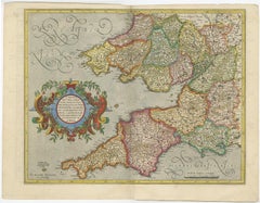
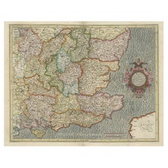
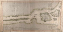
Original Old Map of South East England Incl London, Oxford, Cambridge, Etc, 1633
Located in Langweer, NL
Antique map titled 'Warwicum, Northhamtonia, Huntingdonia, Cantabrigia, Suffolcia, Oxonium
Paper
$552
H 20.48 in W 24.41 in D 0.01 in
Antique Map of the Location of the Garden of Eden and Travels of the Patriarchs
Located in Langweer, NL
Title: Map of the Location of the Garden of Eden and Travels of the Patriarchs Cartographer
Paper
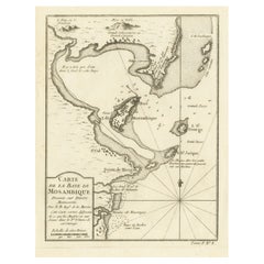
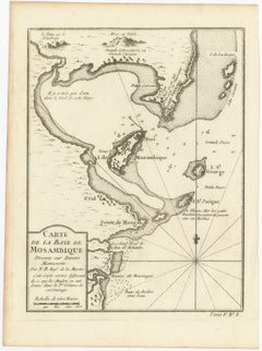
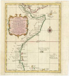
Mozambique Bay – French Naval Sea Chart by Bellin, c.1765
Located in Langweer, NL
compass rose, giving the map a refined, museum-style presentation. Ideal as a stand-alone piece or paired
Paper
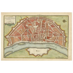
Hand-Colored City Plan of Cologne by Nicolas de Fer, 1705
Located in Langweer, NL
18th century. The map is adorned with a decorative title cartouche and a compass rose that orients the
Paper
$621Sale Price|20% Off
H 20.16 in W 15.56 in D 0 in
Hand-colored Nautical Chart: St. George's Channel and the Irish Sea, 1744
Located in Langweer, NL
western coast of England, as well as part of Scotland. The map features a compass rose in the Irish Sea
Paper
$414Sale Price|20% Off
H 11.42 in W 18.9 in D 0 in
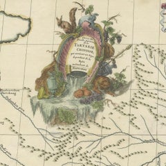
Original Antique Engrving of Chinese Tartary in the 18th Century, 1737
Located in Langweer, NL
compass roses. Some maps bound out of sequence, some folded and some outline hand color. Descriptive text
Paper

$1,275
H 15.75 in W 19.63 in
Map of the World: An Original 18th Century Hand-colored Map by E. Bowen
Located in Alamo, CA
purity of knowledge at the time this map was published. The map is embellished with four Compass Roses
Engraving


$1,875
H 20.5 in W 23.5 in D 1 in
West Africa: 18th Century Hand-colored Homann Map Entitled "Guinea Propria"
By Johann Baptist Homann
Located in Alamo, CA
play around inscribed ivory tusks. One of the children holds a compass tool. This striking map of West
Engraving
French Marble, Gilt Bronze and Amboyna Burl Side Cabinet
Located in London, GB
central gilt bronze plaque, depicting cherubs navigating with globes, telescopes, compasses and maps. The
Marble, Ormolu, Bronze
A New Gradually Encreasing Compass-Map.
Located in Zeeland, Noord-Brabant
A New Gradually Encreasing Compass-Map of the Coming in of the Channel, or the Heads …' - A
Engraving
Unavailable
H 20.56 in W 28.55 in
Antique world map - Erdkugel and compass by Bellin - Handcol. engraving - 18th c
By Jacques-Nicolas Bellin
Located in Zeeland, Noord-Brabant
Description: Map dated 1748, in German. Later also published in Bellin's Atlas 'Histoire des
Engraving

Map of Hell Gate and East River, New York City
Located in New York, NY
compass on the map's upper right. The map's real focus is the river. The passage between Blackwell's
Lithograph

A Chart of Norway.
By Samuel Thornton
Located in Zeeland, Noord-Brabant
A map of the Norwegian coast, from Dronten (Trondheim) south to circa Alesund. The map features two
Engraving
!['The Coast of Newfoundland from Placencia to Cape Bonavista [...].](https://a.1stdibscdn.com/archivesE/upload/a_5923/1509100438016/IMG_0346_2_master.jpg?width=240)
!['The Coast of Newfoundland from Placencia to Cape Bonavista [...].](https://a.1stdibscdn.com/archivesE/upload/a_5923/a_22503631509100449756/IMG_0347_a_master.jpg?width=240)
Unavailable
H 21.15 in W 24.61 in
'The Coast of Newfoundland from Placencia to Cape Bonavista [...].
By Edmond Halley
Located in Zeeland, Noord-Brabant
- A Draught of the River Plata in South America. Four maps on one sheet: a map of Avalon Peninsula
Engraving
Unavailable
H 18.51 in W 22.84 in
Tabula Magellanica qua Tierrae del Fuego.
By Johannes Janssonius
Located in Zeeland, Noord-Brabant
, Tierra del Fuego. Isla de los Estados (Staten Island) is also shown. The map features two compass roses
Engraving
Antique Map of Borneo by Renneville, with Compass Rose and Scale, 1702
Located in Langweer, NL
. With compass rose and scale. This map originates from 'Recueil des Voyages, Des Indes Orientales
Paper
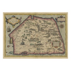
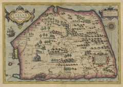
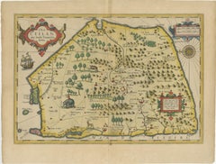
Stunning Antique Map of the Island Ceylon or Sri Lanka
By Gerard Mercator
Located in Langweer, NL
Antique map titled 'Ins. Ceilan quae incolis Tenarisin dicitur'. This exquisite, early map of Sri
Paper
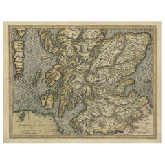
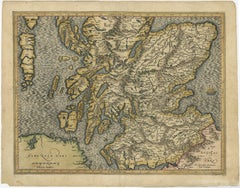
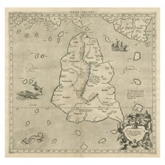
Original Antique Hand-Colored Map of Southern Scotland, ca.1600
Located in Langweer, NL
constant compass bearing on a flat map. Condition: Good, original/contemporary hand coloring. General
Paper

Sold
H 43.31 in W 46.07 in D 1.97 in
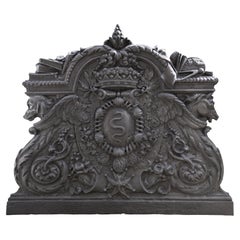
Cast iron fireback with the coat of arms of Colbert, marquis de Seignelay
Located in SAINT-OUEN-SUR-SEINE, FR
be maps and a compass. The marquis de Seignelay was admitted by the king to assist his father
Iron
Sold
H 10.71 in W 14.26 in D 0 in
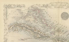
Ornate Cartography of Colonial Grandeur: The West India Islands around 1851
Located in Langweer, NL
the aesthetic appeal of the document. Each section of the map also includes a compass rose, and the
Paper
Sold
H 44.5 in W 36 in D 2 in
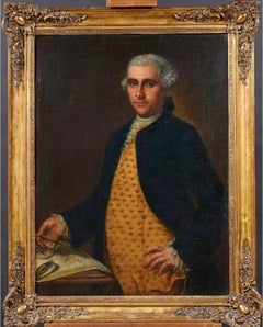
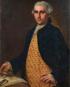
Fine 18th Century Portrait of Explorer/ Merchant Navigator Large Oil Gilt Frame
Located in Cirencester, Gloucestershire
'Navigator holding a compass to map' 18th Century French School oil painting on canvas, framed
Canvas, Oil
Sold
H 3.63 in W 1.5 in D 0.4 in
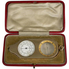
Edwardian Cased Nine-Karat Gold Opisometer or Compass or Map Measuring Tool
By J. C. Vickery
Located in Sittingbourne, Kent
An extremely fine quality Edwardian cased 9 carat gold Opisometer or Map Measuring Tool combined
Produced in 1843, the well-preserved volume is evidence of the author's exacting specifications.
New or old, the coverlets add old-time charm to any space.
Get into the games! These items celebrate the events, athletes, host countries and sporting spirit.
French trendsetter and serial collector Daniel Rozensztroch tells us about his obsession with objects related to seafaring men.
It's hard to resist the allure of a beautiful pool. So, go ahead and daydream about whiling away your summer in paradise.
The sought-after designer worked with the team at Hoffman Creative to produce a monograph that beautifully showcases some of Studio Shamshiri's most inspiring projects.
Italian writer and collector Umberto Pasti opens the doors to his remarkable cave of wonders in North Africa.
Hollywood A-listers, ex-pat aristocrats and art collectors and style setters of all stripes appreciate the allure of the coastal California hamlet — much on our minds after recent winter floods.