Items Similar to Original Antique Map of the English counties Cornwall, Devon, Dorset, etc, 1633
Want more images or videos?
Request additional images or videos from the seller
1 of 5
Original Antique Map of the English counties Cornwall, Devon, Dorset, etc, 1633
About the Item
Antique map titled 'Cornubia, Devonia, Somersetus, Dorcestria, Wiltonia, Glocestria, Monumetha, Glamorgan, Caermarden, Penbrok, Cardigan, Radnor, Breknoke et Herfordia'.
Old map of the English counties of Cornwall, Devon, Somerset, Dorset, Wiltshire, Gloucestershire, Herefordshire, Worcestershire etc. Originates from the 1633 German edition of the Mercator-Hondius Atlas Major, published by Henricus Hondius and Jan Jansson under the title: 'Atlas: das ist Abbildung der gantzen Welt, mit allen darin begriffenen Laendern und Provintzen: sonderlich von Teutschland, Franckreich, Niderland, Ost und West Indien: mit Beschreibung der selben.'
Artists and Engravers: Gerard Mercator (1512 - 1594) originally a student of philosophy was one of the most renowned cosmographers and geographers of the 16th century, as well as an accomplished scientific instrument maker. He is most famous for introducing Mercators Projection, a system which allowed navigators to plot the same constant compass bearing on a flat map.
- Dimensions:Height: 16.15 in (41 cm)Width: 21.26 in (54 cm)Depth: 0 in (0.02 mm)
- Materials and Techniques:
- Period:1630-1639
- Date of Manufacture:1633
- Condition:Repaired: Some expert restorations (strengthenings) along flattened middle fold. Wear consistent with age and use. Condition: Good, German text on verso. Slightly waterstained in upper margin.Some expert restorations (strengthenings) along flattened middle fold. Please study image carefully.
- Seller Location:Langweer, NL
- Reference Number:
About the Seller
5.0
Platinum Seller
These expertly vetted sellers are 1stDibs' most experienced sellers and are rated highest by our customers.
Established in 2009
1stDibs seller since 2017
1,922 sales on 1stDibs
Typical response time: <1 hour
- ShippingRetrieving quote...Ships From: Langweer, Netherlands
- Return PolicyA return for this item may be initiated within 14 days of delivery.
More From This SellerView All
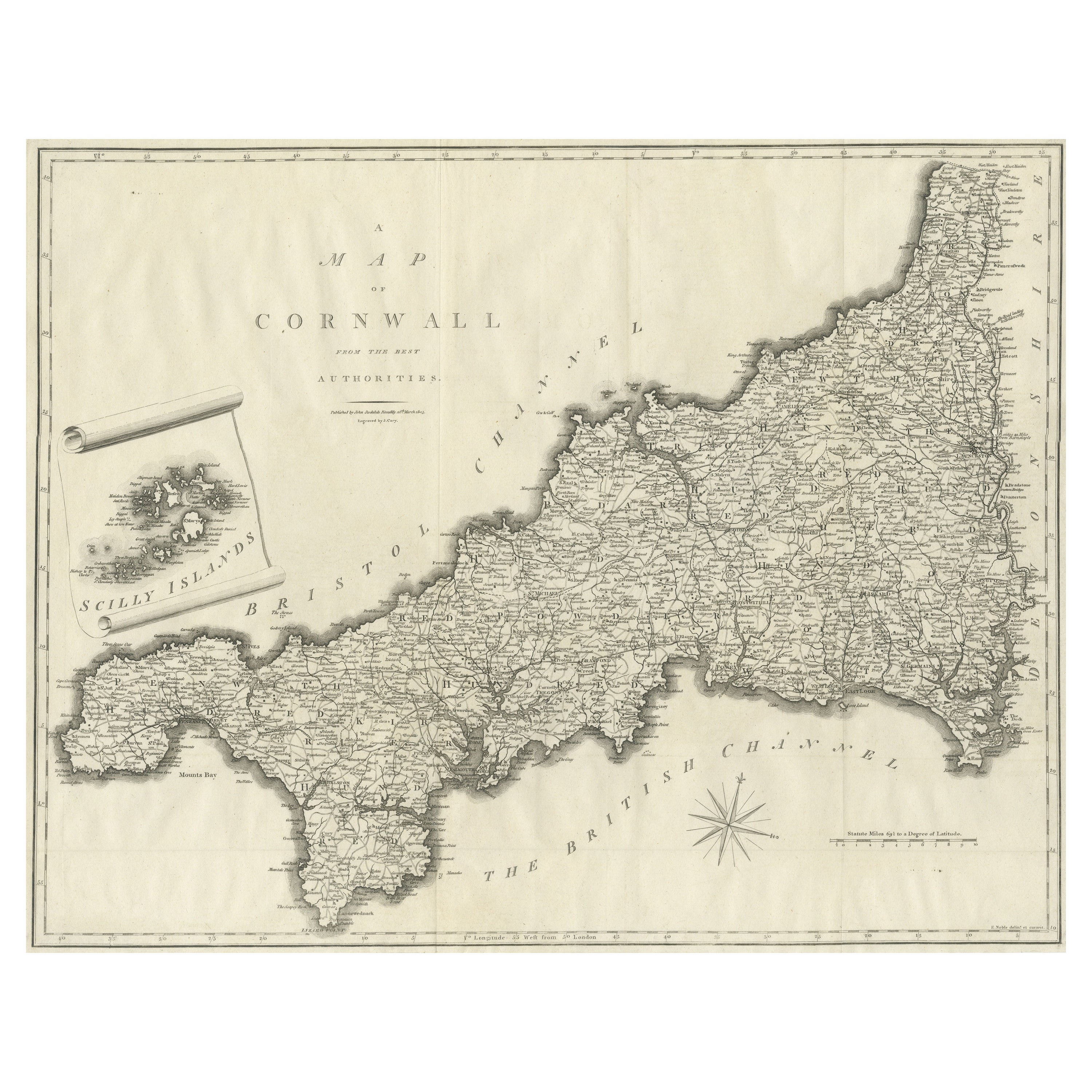
- Large Antique County Map of Cornwall and the Isles of Scilly, EnglandLocated in Langweer, NLAntique map titled 'A Map of Cornwall from the best Authorities'. Original old county map of Cornwall, England. With inset map of the Scilly Islands. Engraved by John Cary. Originate...Category
Antique Early 19th Century Maps
MaterialsPaper
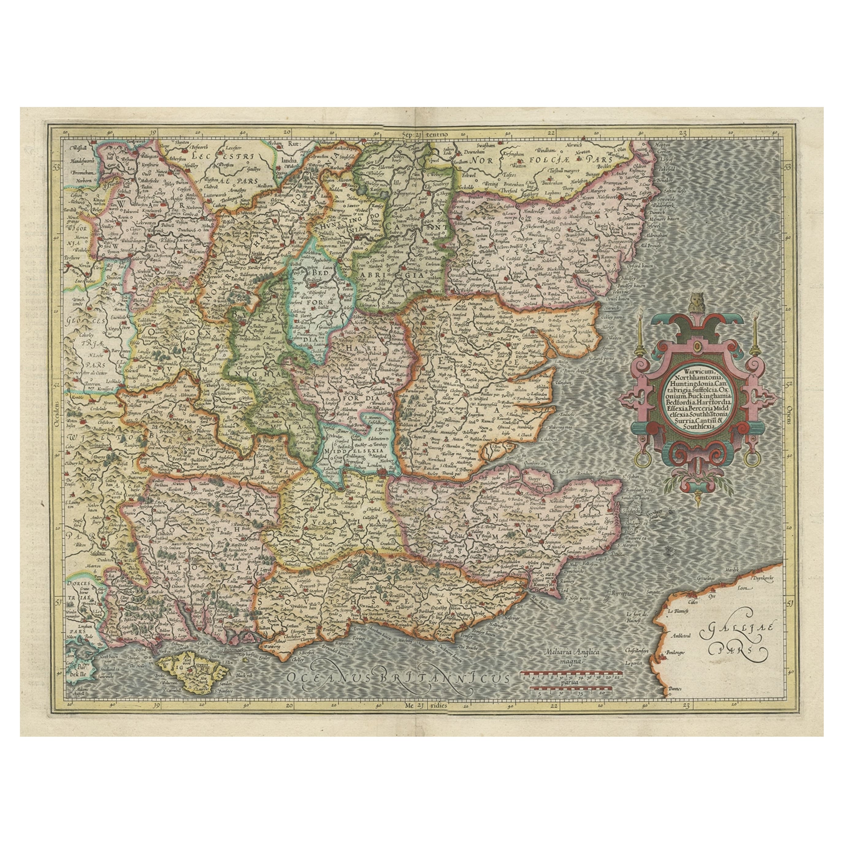
- Original Old Map of South East England Incl London, Oxford, Cambridge, Etc, 1633Located in Langweer, NLAntique map titled 'Warwicum, Northhamtonia, Huntingdonia, Cantabrigia, Suffolcia, Oxonium, Buckinghamia, Befordia, Harfordia, Essexia, Berceria, Middlesexia, Southhatonia, Surria, Catiu & Southsexia'. Old map of south east England. Includes London, Salisbury, Oxford, Cambridge, Leicester and Norwich and the Isle of Wight. Originates from the 1633 German edition of the Mercator-Hondius Atlas Major, published by Henricus Hondius and Jan Jansson under the title: 'Atlas: das ist Abbildung der gantzen Welt, mit allen darin begriffenen Laendern und Provintzen: sonderlich von Teutschland, Franckreich, Niderland, Ost und West Indien: mit Beschreibung der selben.' Artists and engravers: Gerard Mercator (1512 - 1594) originally a student of philosophy was one of the most renowned cosmographers and geographers of the 16th century, as well as an accomplished scientific instrument maker. He is most famous for introducing Mercators Projection, a system which allowed navigators to plot the same constant compass bearing on a flat map.Category
Antique 1630s Maps
MaterialsPaper
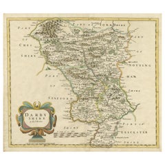
- Original Antique County Map of Derbyshire, EnglandLocated in Langweer, NLAntique map titled 'Darbyshire'. Original antique map of the country of Derbyshire, England. Engraved by Robert Morden. Sold by Abel Swale, Awnsham and John Churchill...Category
Antique Late 17th Century Maps
MaterialsPaper
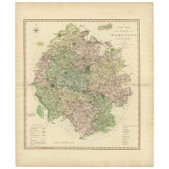
- Original Hand-Colored Antique Map of the County of Hereford in England, 1804Located in Langweer, NLAntique county map of Herefordshire first published c.1800. Villages, towns, and cities illustrated Avenbury, Ashpurton, Kineton, and Bromyard. ...Category
Antique Early 19th Century Maps
MaterialsPaper
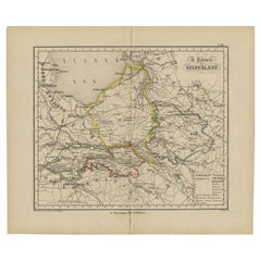
- Antique Map of Gelderland with the Veluwe Etc, the Netherlands, 1864Located in Langweer, NLAntique map titled 'De Provincie Gelderland'. Map of the province of Gelderland, the Netherlands. This map originates from 'F. C. Brugsma's Atlas van het Koninkrijk der Nederland...Category
Antique 19th Century Maps
MaterialsPaper
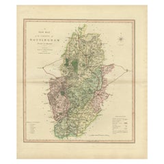
- Antique Decorative Map of The County of Nottinghamshire, England, 1804Located in Langweer, NLAntique county map of Nottinghamshire first published c.1800. Villages, towns, and cities illustrated include Worksop, Neware, Tuxford, and Maplebe...Category
Antique Early 1800s Maps
MaterialsPaper
You May Also Like
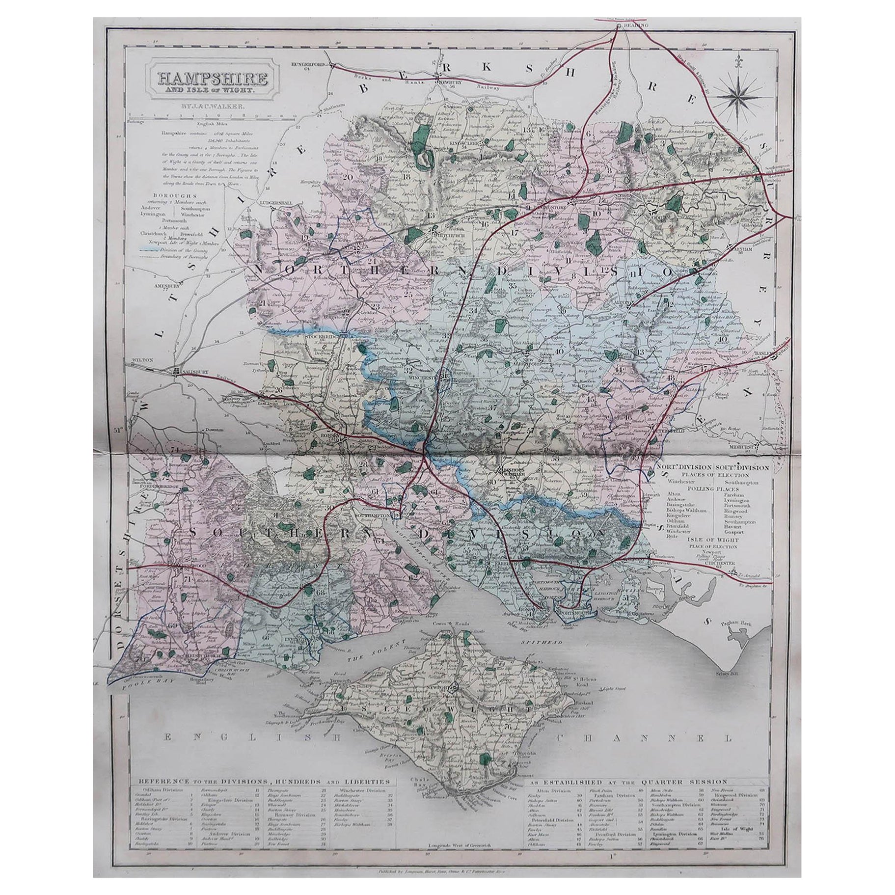
- Original Antique English County Map, Hampshire, J & C Walker, 1851Located in St Annes, LancashireGreat map of Hampshire Original colour By J & C Walker Published by Longman, Rees, Orme, Brown & Co. 1851 Unframed.Category
Antique 1850s English Other Maps
MaterialsPaper
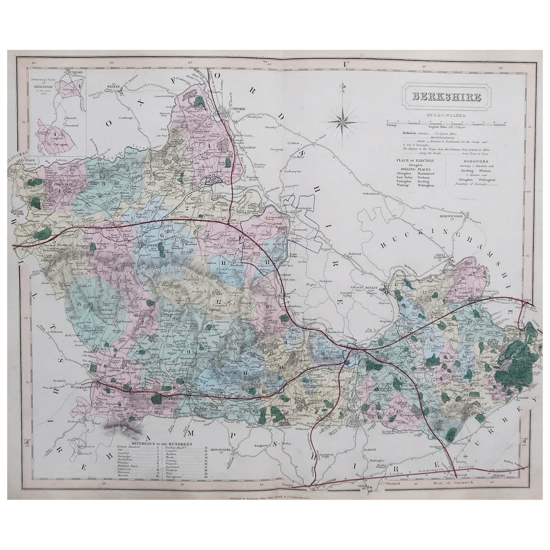
- Original Antique English County Map, Berkshire. J & C Walker, 1851Located in St Annes, LancashireGreat map of Berkshire Original colour By J & C Walker Published by Longman, Rees, Orme, Brown & Co. 1851 Unframed.Category
Antique 1850s English Other Maps
MaterialsPaper
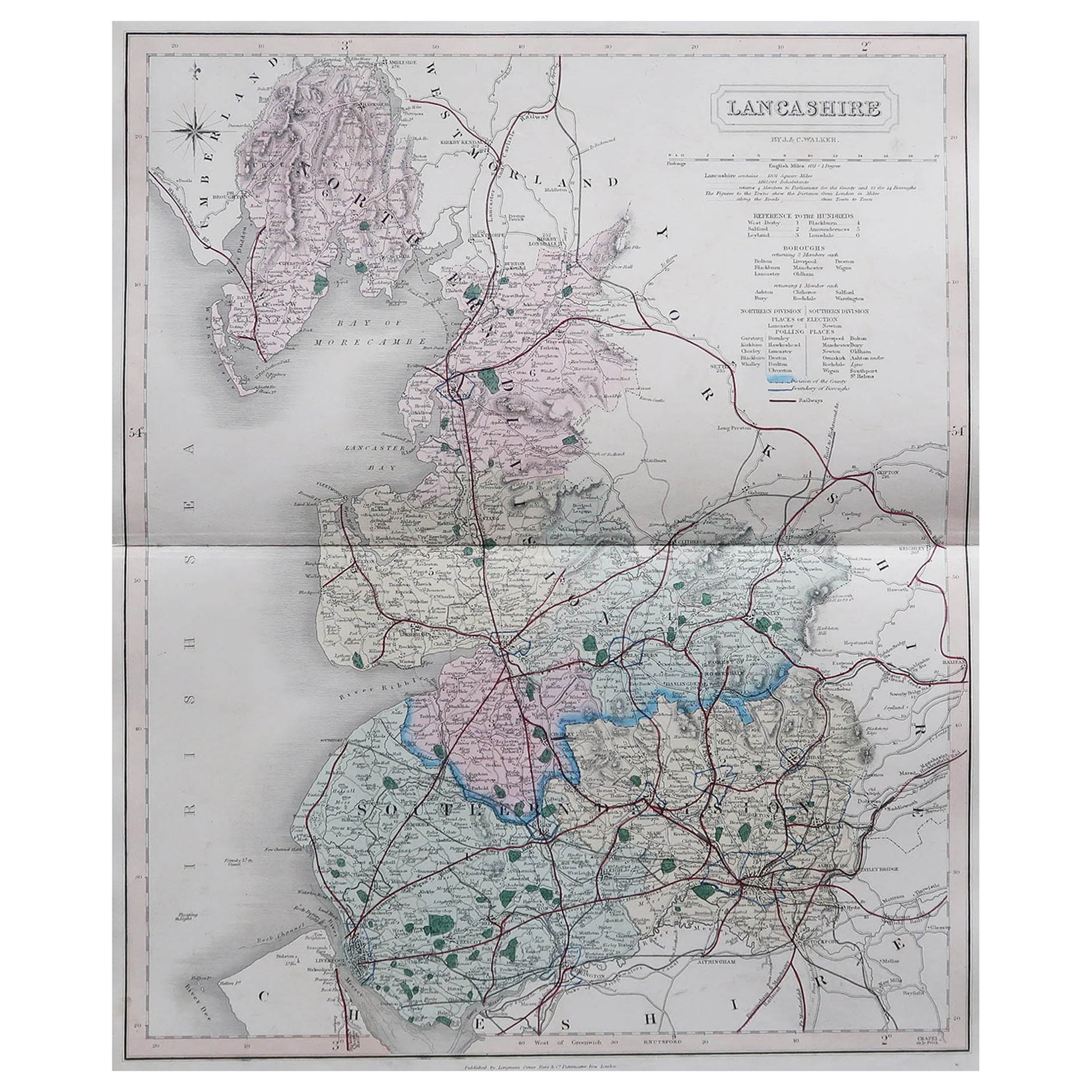
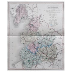
- Original Antique English County Map, Lancashire, J & C Walker, 1851Located in St Annes, LancashireGreat map of Lancashire Original colour By J & C Walker Published by Longman, Rees, Orme, Brown & Co. 1851 Unframed.Category
Antique 1850s English Other Maps
MaterialsPaper
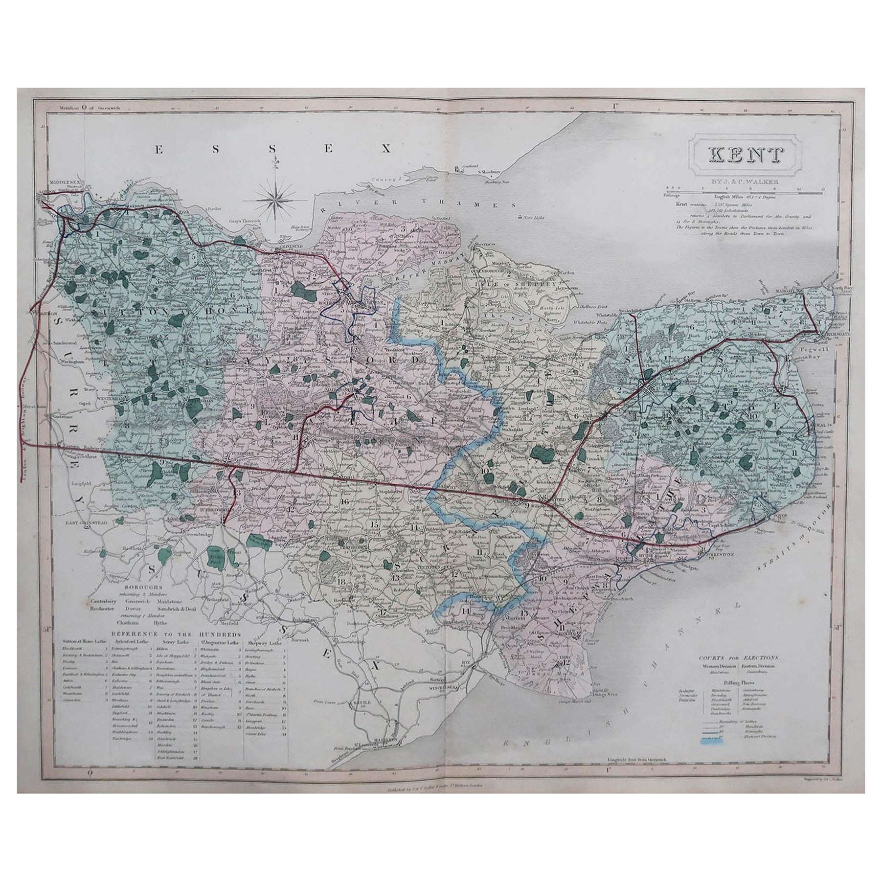
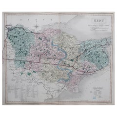
- Original Antique English County Map, Kent. J & C Walker, 1851Located in St Annes, LancashireGreat map of Kent Original colour By J & C Walker Published by Longman, Rees, Orme, Brown & Co. 1851 Unframed.Category
Antique 1850s English Other Maps
MaterialsPaper
- Original Antique English County Map, Rutland, J & C Walker, 1851Located in St Annes, LancashireGreat map of Rutland Original colour By J & C Walker Published by Longman, Rees, Orme, Brown & Co. 1851 Unframed.Category
Antique 1850s English Other Maps
MaterialsPaper
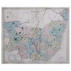
- Original Antique English County Map, Suffolk, J & C Walker, 1851Located in St Annes, LancashireGreat map of Suffolk Original colour By J & C Walker Published by Longman, Rees, Orme, Brown & Co. 1851 Unframed.Category
Antique 1850s English Other Maps
MaterialsPaper


Recently Viewed
View AllMore Ways To Browse
16th Century English
English 16th Century Furniture
16th Century English Antique
Antique Devon
Compass Map
Used Furniture Devon
Somerset Antique
Allen Antique Furniture
Antique County Maps
Antique Map Compass
Compass Antique Map
Antique Compass Map
Mercator Map
Mercator Antique
Used Furniture Dorset
West German Antiques
Antique Furniture Devon
Map Hondius